Rio de Janeiro (state)
| State of Rio de Janeiro | |||
|---|---|---|---|
| — State — | |||
|
|||
| Motto: Recte Rem Publicam Gerere (Latin) "Conduct the affairs of the public with righteousness" |
|||
| Anthem: November 15th | |||
 |
|||
| Coordinates: | |||
| Country | |||
| Capital and Largest City | Rio de Janeiro | ||
| Government | |||
| - Governor | Sérgio Cabral Filho | ||
| - Vice Governor | Luís Fernando de Sousa | ||
| Area | |||
| - Total | 43,696.1 km2 (16,871.2 sq mi) | ||
| Area rank | 24th | ||
| Population | |||
| - Estimate (2006) | 15,561,720 | ||
| - Rank | 3rd | ||
| - Density rank | 2nd | ||
| Demonym | Fluminense | ||
| GDP | |||
| - Year | 2006 estimate | ||
| - Total | R$ 296,768,000,000 (2nd) | ||
| - Per capita | R$ 17,695 (3rd) | ||
| HDI | |||
| - Year | 2005 | ||
| - Category | 0.832 – high (3rd) | ||
| Time zone | BRT (UTC-3) | ||
| - Summer (DST) | BRST (UTC-2) | ||
| Postal Code | 20000-000 to 28990-000 | ||
| ISO 3166 code | BR-RJ | ||
| Website | governo.rj.gov.br | ||
Rio de Janeiro (Portuguese pronunciation: [ˈʁi.u dʒi ʒaˈnejɾu] [1]) is one of the 27 states of Brazil.
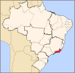
The state of Rio de Janeiro is located within the Brazilian geopolitical region classified as the Southeast (assigned by IBGE) and its boundaries, all of them with other Brazilian states in the Southeast region (Rio de Janeiro is the only state in the Southeast to share borders with all other states in the same macroregion), are with Minas Gerais (N and NW), Espírito Santo (NE) and São Paulo (SW), and plus its shore line, in the Atlantic Ocean, to its East and South.
Rio de Janeiro has an area of 43,653 km². Its capital is the city of Rio de Janeiro, which was the capital of the Portuguese Colony of Brazil from 1763 to 1806, capital of the United Kingdom of Portugal, Brazil and the Algarves from 1806 to 1822, and capital of independent Brazil from 1822 to 1960.
The state's largest cities are Rio de Janeiro, Nova Iguaçu, Niterói, Duque de Caxias, São Gonçalo, São João de Meriti, Campos dos Goytacazes, Petrópolis and Volta Redonda.
Its principal rivers are the Guandu, the Piraí, the Paraíba do Sul, the Macaé and the Muriaé. Its climate is considered to be tropical.
Rio de Janeiro is made up of two distinct morphological areas: a plain, known as baixada, and a plateau, which are disposed in parallel fashion from the shoreline inland (towards Minas Gerais).
In the Brazilian flag, the state is represented by the Beta star in the Southern Cross (β = Mimosa).
Contents |
Geography

The state is part of the Mata Atlântica biome, and its topography comprises both mountains and plains, located between the Mantiqueira Mountains and the Atlantic Ocean. Its coast is formed by the bays of Guanabara, Sepetiba, and Ilha Grande.
There are prominent slopes near the ocean, featuring also diverse environments, such as restinga vegetation, bays, lagoons and tropical forests.
Rio de Janeiro is the smallest state in the Southeast macroregion and one of the smallest in Brazil. It has, however, the third longest coastline in the country (second only to those of Bahia and Maranhão), extending 635 kilometers.
History
Hereditary captainships


Rio de Janeiro was originated from parts of the captainships of de Tomé and São Vicente. Between 1555 and 1567, the territory was busy with the Frenchmen, who intended to install a colony, France Antarctique. Aiming to prevent the occupation of the Frenchmen, in March 1565, the city of Rio de Janeiro was established by Estácio de Sá.
In the 17th century, cattle raising and sugar cane cultivation stimulated the city's progress which was definitively assured when the port started to export gold extracted from Minas Gerais in 18th century. In 1763, Rio de Janeiro became the headquarters of Colonial Brazil and the capital of the colony. With the flight of the Portuguese royal family from Portugal to Brazil, in 1808, the region soon benefited from urban reforms to house the Portuguese. Chief among the promoted changes were: the transfer of agencies of public administration and justice, the creation of new churches, and hospitals, the foundation of the first bank of the country - the Banco do Brasil - and the Royal Press, with the Gazette do Rio of Janeiro. Following years witnessed the creation of the Jardim Botânico and the Academia Real Militar.
There followed a process of cultural enhancement influenced not only by the arrival of the Royal Family, but also by the presence of European graphic artists who were hired to record the society and Brazilian natural features. During this same time, the Escola Real de Ciências, Artes e Ofícios (The Royal School of Sciences, Arts, and Works) was founded as well.
The Neutral City
In 1834, the city of Rio de Janeiro was transformed into neutral city, remaining as capital of the state, while the captainships became provinces, with headquarters in Niterói, a neighboring city. In 1889, the city became the capital of the Republic, the neutral city became the federal district and the province in State. With the move of the federal capital to Brasilia, in 1960, the city of Rio de Janeiro became the State of Guanabara.
The new State of Rio de Janeiro
In 1975, the states of Guanabara and Rio de Janeiro were merged under the name of Rio de Janeiro, with the city of Rio de Janeiro as state capital. The symbols of the former State of Rio de Janeiro were preserved, while the symbols of Guanabara were kept by the city of Rio de Janeiro. It should be noted that the European presence in Rio de Janeiro is as old as Brazil itself, dating back to 1502 under this name.
Demographics

According to the IBGE of 2008, there were 15,772,000 people residing in the state. The population density was 352.58 inhabitants per square kilometre (913.2 /sq mi).
Urbanization: 96.9% (2004); Population growth: 1.3% (1991–2000).
The last PNAD (National Household Survey) census revealed the following numbers: 8,509,000 White people (54.25%), 5,302,000 Brown (Multiracial) people (33.81%), 1,809,000 Black people (11.53%), 25,000 Asian people (0.16%), 19,000 Amerindian people (0.12%).[2]
People of Portuguese ancestry predominate in most of the state. Other European ethnic groups, such as Swiss and Germans settled mostly in the mountainous areas (Nova Friburgo, Petrópolis, etc) and in the capital. Italians and Spaniards are also present in the capital as well as in the surrounding cities.[3][4]
People of African descent are numerous, particularly in the capital city. Those of mixed-race ancestry (mulattoes) make up the majority of the population in some towns.
Economy
The industrial sector is the largest component of GDP at 51.6%, followed by the service sector at 47.8%. Agriculture represents 0.6% of GDP (2004). Rio de Janeiro (state) exports: petroleum 44.8%, fuel 17.5%, siderurgy 13%, chemicals 3.6%, not ferrous metals 2.8%, vehicles 2.1% (2002).
Participation in the Brazilian economy: 15.6% (2004).[5]
Trivia
Vehicles: 3.915.724 (jan./2006); Mobile phones: 10 million (2006); Telephones: 5.3 million (2006). Cities: 92 (2006). Area: The state of Rio de Janeiro is more than double the size of: El Salvador, Slovenia, Chechnya, Hawaii (USA). It is slightly larger than: Denmark, Netherlands,and Switzerland. The state is slightly smaller than: Estonia, Dominican Republic, and Slovakia.
Education
Colleges and Universities
Public Institutions
- Universidade Federal do Rio de Janeiro (UFRJ) (Federal University of Rio de Janeiro);
- Instituto Militar de Engenharia (IME);
- Universidade Federal do Estado do Rio de Janeiro (UNIRIO) (Federal University of State of Rio de Janeiro);
- Universidade do Estado do Rio de Janeiro (UERJ) (Rio de Janeiro State University);
- Universidade Estadual do Norte Fluminense "Darcy Ribeiro" (UENF) (State University of Norte Fluminense "Darcy Ribeiro");
- Universidade Federal Fluminense (UFF) (Fluminense Federal University);
- Universidade Federal Rural do Rio de Janeiro (UFRRJ) (Rural Federal University of Rio de Janeiro);
- Universidade Estadual da Zona Oeste (UEZO) (State University of Zona Oeste);
Private Colleges
- Fundação Getúlio Vargas (FGV)
- Pontifícia Universidade Católica do Rio de Janeiro (PUC-Rio);
- Universidade do Grande Rio (UNIGRANRIO) (University of Great Rio);
- Universidade Estácio de Sá
- Universidade Gama Filho
- Universidade Veiga de Almeida (UVA)
- Universidade Cândido Mendes (UCAM)
- Centro Universitário Augusto Motta (Unisuam)
Culture
Carnival

It is the great explosion of joy in Rio. A party uniting emotions, creativity, plasticity, colours, sounds and much fantasy. It is the greatest popular party in the world. A unique record of the rich cultural melting pot typical of Brazil.
New Year’s Eve
In Rio de Janeiro, New Year’s Eve celebration involves the whole city population. Local inhabitants and visitors join to celebrate taken by the same euphoria: to be in Rio. The party, one of the most famous in the world, is held on the famous beach of Copacabana, gathering thousands of people to enjoy musical performances and fireworks – increasingly exuberant year after year. One tradition is to give gifts to Yemanja, like flowers and even blancmange.
Infrastructure
International Airport

Since August 2004, with the transfer of many flights from Santos Dumont Airport, Rio de Janeiro-Galeão International Airport has returned to being the main doorway to Brazil. According to data from the official Brazilian travel bureau, Embratur, nearly 40% of foreign tourists who visit Brazil choose Rio as their gateway, meaning Galeão Airport. Besides linking Rio to the rest of Brazil with domestic flights, Galeão has connections to 18 other countries. It can handle up to 15 million passengers a year in two passenger terminals. Located 20 kilometers from downtown Rio, the international airport is served by several quick access routes, such as the Linha Vermelha and Linha Amarela freeways and Avenida Brasil, thus conveniently serving residents of the city’s southern, northern and western zones. There are special shuttle buses linking Galeão to Santos Dumont, and bus and taxi service to the rest of the city. The airport complex also has Brazil’s longest runway at 4,240 metres (13,910 ft), and one of South America’s largest and best equipped cargo logistics terminals.
Highways
The main Federal highways that cross the state are:
- BR-101
- BR-116
- BR-040
- BR-354
- BR-356
- BR-393
- BR-465
- BR-493
- BR-495
Sports
More notable sports events in Rio include the MotoGP Brazilian Grand Prix and the World Beach volleyball finals. Jacarepaguá was the place of Formula One Brazilian Grand Prix into 1978-1990 and the Champ Car event into 1996-1999. WCT/WQS Surf championships were contested on the beaches from 1985-2001. The city has built a new stadium near the Maracanã, to hold 45,000 people. It was named after Brazilian ex-FIFA president João Havelange. Sports are a very popular pastime in Rio de Janeiro. The most popular is futebol (soccer). Rio de Janeiro is home to four traditional Brazilian football clubs: Flamengo, Fluminense, Vasco, and Botafogo.
Rio de Janeiro will be hosting the 2014 FIFA World Cup.
On the 2nd of October, Rio de Janeiro, Brazil, was selected to host the 2016 Olympic Games, which will be the first to be held in South America.[6]
State flag
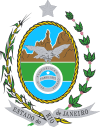
In the foreground of the state flag, an eagle, symbol of Brazil's royal family, appears. In the background, the rock formation Dedo de Deus ("The Finger of God"), which is visible from the city of Rio de Janeiro in a clear day. The outer part of the coat of arms represents the state's agricultural richness, sugarcane (left) and coffee (right).
Cities
- List of municipalities in Rio de Janeiro
See also
- List of Governors of Rio de Janeiro
- Legislative Assembly of Rio de Janeiro
References
- ↑ In the variety of Brazilian Portuguese spoken in Rio de Janeiro. The European Portuguese pronunciation is: [ˈʁiu dɨ ʒɐˈnɐjɾu].
- ↑ (in Portuguese) (PDF). State of Rio de Janeiro, Brazil: IBGE. 2008. ISBN 85-240-3919-1. http://www.sidra.ibge.gov.br/bda/tabela/listabl.asp?z=pnad&o=3&i=P&c=262. Retrieved 2010-01-18.
- ↑ A Colônia Suíça de Nova Friburgo
- ↑ A colonização alemã em Petrópolis
- ↑ (in Portuguese) (PDF) List of Brazilian states by GDP. State of Rio de Janeiro, Brazil: IBGE. 2004. ISBN 85-240-3919-1. http://en.wikipedia.org/wiki/List_of_Brazilian_states_by_GDP_participation. Retrieved 2007-07-18.
- ↑ The Guardian, October 2, 2009, Olympics 2016: Tearful Pele and weeping Lula greet historic win for Rio
External links
- Official Website (Portuguese)/(English)
- Brazilian Tourism Portal
- State Judiciary (Portuguese)
- State Assembly (Portuguese)
- State University (Portuguese)/(English)
- Northern State University (Portuguese)
- State Attornery Office (Portuguese)
- State Civil Defence (Portuguese)
- State Military Police (Portuguese)
- State Civil Police (Portuguese)
- Group Fotolog - Rio de Janeiro (Portuguese)
- (English) Carnival in Rio de Janeiro
|
||||||||||||||||||||||||||||||||||||||
|
||||||||||||||||||||||||||||||||
|
||||||||||||||||||||


