Rhaetian Railway
| Rhaetian Railway in the Albula / Bernina Landscapes* | |
|---|---|
| UNESCO World Heritage Site | |
 The Glacier Express in the Albula Valley. |
|
| State Party | |
| Type | Cultural |
| Criteria | ii, iv |
| Reference | 1276 |
| Region** | Europe and North America |
| Inscription history | |
| Inscription | 2008 (32nd Session) |
| * Name as inscribed on World Heritage List. ** Region as classified by UNESCO. |
|
The Rhaetian Railway (German: Rhätische Bahn, Italian: Ferrovia Retica, Romansh: Viafier Retica, abbreviated RhB) is a Swiss transport company, owning the largest network of all the private railways in Switzerland. The company operates most of the railways in the Swiss canton of Graubünden as the Swiss federal railway company SBB-CFF-FFS extend only a few kilometres over the cantonal border to the capital at Chur. Almost the entire network is in Graubünden, with one station at Tirano in Italy.
The Rhaetian Railway serves a number of major tourist centres, including St Moritz and Davos. One of the lines, the Berninabahn, crosses the Bernina Pass to the Italian border and on to Tirano, Lombardy, where there is a link to the Italian railways.
In 2008 the Rhaetian Railway in the Albula / Bernina Landscapes (the part from Thusis to Tirano, including St. Moritz) was added to the list of UNESCO World Heritage Sites.
Figures
- Travellers per year (2008): 10.7 million
- Revenue (2008): 308,700,000 sFr.
- Profit (2008): 1,700,000 sFr.
- Employees (2008): 1,348
- Total rolling stock (2008): 1,294
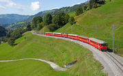
Network and services
| Rhätische Bahn | |
|---|---|
|
 RhB train on the Landwasser Viaduct |
|
| Locale | Switzerland |
| Track gauge | 1,000 mm (3 ft 3 3⁄8 in) |
| Electrification | 11 kV 16⅔ Hz (322 km) 1000 V DC (62 km, Bernina line) |
| Length | 384 km (238.6 mi) |
| Headquarters | Chur |

| Rhaetian Railway | |
|---|---|
| Technical | |
| Electrification | 11 kV 16⅔ Hz (322 km) 1000 V DC (62 km, Bernina line) |
| Maximum incline | 4 %, except Bernina line 7 % |
| Rack system | None |
Overview
The RhB network was developed in various stages at the end of the 19th and early 20th centuries, with the result that several different electrification systems are in use, and one 12-kilometre section between Castione and Cama was completely separate from all other railways following a landslide in the mid-20th century, before later closure. All the RhB is of 1,000 mm (3 ft 3 3⁄8 in) gauge ("metre gauge") and is electrified:
- 61 km (37.9 mi), the Bernina Railway (Pontresina - Tirano) is electrified at 1000 V DC.
- 321 km (199.5 mi) is electrified at 11 kV 16⅔ Hz (including Chur-Arosa and the new Vereina tunnel route).
The network contains 84 tunnels (the longest being the 19.042-kilometre (11.832 mi) Vereina Tunnel, opened on 19 November 1999, and the 5.864-kilometre (3.644 mi) Albula Tunnel), plus 383 bridges. The maximum gradient is 4.5%, except on the Bernina Railway, where it is 7%[1].
Current services operated by the RhB (2008):
- Basic hourly service:
- Regio Express RE1: Chur – St. Moritz
- Regio Express RE2: Landquart – Davos
- Regio Express RE3: Disentis/Muster - Chur – Landquart - Scuol-Tarasp
- Regio R4: Chur – Arosa (the "Arosabahn")
- Regio R5: St. Moritz - Tirano (Italy)
- Regio R6: Davos Platz - Filisur
- Regio R7: Pontresina - Sagliains - Scuol-Tarasp
- S-Bahn S8: Schiers - Landquart - Chur - Rhäzüns
- S-Bahn S9: Chur - Thusis
- Off-peak hours:
- Regio R11: Chur - St. Moritz
- Regio R21: Landquart - Davos
- Regio R31: Disentis - Landquart
- Vehicle transporter services:
- Through the Vereina Tunnel: Klosters - Sagliains.
- Through the Albula Tunnel: Thusis - Samedan.
The annual traffic carried by the RhB (2002) is 300,000,000 passenger-kilometres, and 54,000,000 tonne-kilometres of freight. 80% of passenger income comes from tourists, although 40% of passengers are local people.
Landquart-Davos line
Landquart railway station in Graubünden is the starting point of the Rhaetian Railway, historically as part of the Landquart-Davos line, operationally as the company's main workshop, and topologically as the 0 kilometre point of the company's core network. The Landquart-Davos line is the oldest in the Rhaetian Railway network.
After leaving Landquart, the line to Davos crosses the Landquart River, and then generally follows the river upstream as far as Klosters, crossing the river several times along the way.
Just beyond Klosters, there are two tunnels. One of these is for the Vereina line (see below). The other, the Klosters loop tunnel, takes the Davos line at a 45 degree angle towards the west. The line to Davos then loops back towards the east, inside the Cavadürli loop tunnel, and continues through dense larch and other coniferous forests to the Davos Laret.
Highest point on the line is the the next stop, Davos Wolfgang. Then the line leads back down and along Lake Davos to Davos Dorf, and the terminus at Davos Platz.
Davos–Filisur line
The connecting line from Davos Platz to the Albula Railway at Filisur passes through wild gorges, and is technically very interesting, not only due to its famous Wiesen Viaduct.
The Davos–Filisur line is 19 km long, runs through 14 tunnels extending a total of 4200 m in length, and crosses 28 bridges. It was electrified in 1919.
Landquart-Thusis line

Starting in the Rhine valley, the Landquart-Thusis line runs more or less parallel with the SBB-CFF-FFS Sargans-Landquart-Chur standard gauge line as far as Chur (585 m). The line to Thusis then simply follows the course of the Rhine to Bonaduz (655 m). From there, it enters the Domleschg Valley and follows the Posterior Rhine from Rhäzüns (658 m) to Thusis (697 m).
Albula line (Thusis–St. Moritz)
This line begins in Thusis (697 m). It continues toward Tiefencastel (851 m) following the Albula river and then crosses the Landwasser Viaduct before arriving at Filisur (1032 m). Shortly after Filisur the line passes its first spiral tunnel then continues to Bergün/Bravuogn (1373 m).
Between Bergün/Bravuogn and Preda (1789 m), at the end of the valley, the line has to achieve a difference in height of about 400 meters inside a horizontal distance of 5 kilometres, without using rack-and-pinion, but with many spirals. Then the line enters the Albula Tunnel at 1,815 metres under the Albula Pass. It emerges in the Val Bever, where it reaches Bever (1,708 m) on the Engadin plain. The line continues toward Samedan (1,721 m) and arrives at St.Moritz (1,775 m).
Albula tunnel
In 2009 it was announced that an examination of the Albula Tunnel conducted in 2006 had found major degradation of the tunnel, with over 60% of the lining in need of replacement. Furthermore, the bores are small by modern standards, and cabling, signalling and drainage all need replacement. As a result, it was announced that an inquiry would decide from two options a course action; either comprehensive renewal of the existing tunnel or the construction of a new bore to modern standards. In any case, after assessments and financing, which could be potentially complicated due to the split ownership of the tunnel, no construction will start until 2011 no matter what is decided.[2]
Reichenau-Disentis/Mustér line

The line from Reichenau to Disentis/Mustér links the rest of the Rhaetian Railway network with the Matterhorn-Gotthard-Bahn. It branches from the line to Thusis behind the shared Rhine bridge.
In contrast with the accompanying road, which rises about 500 meters towards Flims and Laax, the railway to Disentis/Mustér runs slowly up the narrow "Ruinaulta" valley. On this part of the line, its associated engineering structures dominate the otherwise pristine natural landscape.
At Ilanz, the railway line and road merge paths once again Their combined pathways then rise slowly and evenly to Disentis/Mustér.
Engadin line (Pontresina – Scuol-Tarasp)

Description coming soon.
Bernina line (St.Moritz–Tirano)
This line leaves St.Moritz and heads towards Pontresina (1,774 m) in the Val Bernina. It ascends progressively the valley to the Bernina Pass passing the Morteratsch station (1,896 m), where the traveler can see the glacier of the same name and the highest summit of the Eastern Alps, the Piz Bernina. Before arriving at the pass the line runs through Bernina Diavolezza (2,093 m) where an aerial tramway leads to Diavolezza. The line reaches its highest point - at 2,253 metres ASL - near to the Ospizio Bernina station above the Lago Bianco; this is also the highest point on the entire RhB network.
Alp Grüm (2,091 m) is the first station south of the Alps, situated above the Lago Palü and right below the Piz Palü and its glacier. After many hairpin turns the line reaches Cavaglia (1,693 m) above the Val Poschiavo, then the Swiss Italian-speaking town of Poschiavo at 1,014 meters.
The line then follows the course of the Poschiavino and stops at Le Prese (964 m) and Miralago (965 m) both on Lake Poschiavo's shore. After Miralago it continues its descent toward Brusio (780 m), where it passes the spiral of the Brusio Viaduct. Shortly after having passed the Italian border at Campocologno (553 m) the line reaches Tirano RhB station at 430 meters.
Arosa line (originally Chur-Arosa (ChA))
| Chur–Arosa line details Distances & lengths are in kilometres and metres. only tunnels over 100 metres long are specified |
|||||||||||||||||||||||||||||||||||||||||||||||||||||||||||||||||||||||||||||||||||||||||||||||||||||||||||||||||||||||||||||||||||||||||||||||||||||||||||||||||||||||||||||||||||||||||||||||||||||||||||||||||||||||||||||||||||||||||||||||||||||||||||||
|---|---|---|---|---|---|---|---|---|---|---|---|---|---|---|---|---|---|---|---|---|---|---|---|---|---|---|---|---|---|---|---|---|---|---|---|---|---|---|---|---|---|---|---|---|---|---|---|---|---|---|---|---|---|---|---|---|---|---|---|---|---|---|---|---|---|---|---|---|---|---|---|---|---|---|---|---|---|---|---|---|---|---|---|---|---|---|---|---|---|---|---|---|---|---|---|---|---|---|---|---|---|---|---|---|---|---|---|---|---|---|---|---|---|---|---|---|---|---|---|---|---|---|---|---|---|---|---|---|---|---|---|---|---|---|---|---|---|---|---|---|---|---|---|---|---|---|---|---|---|---|---|---|---|---|---|---|---|---|---|---|---|---|---|---|---|---|---|---|---|---|---|---|---|---|---|---|---|---|---|---|---|---|---|---|---|---|---|---|---|---|---|---|---|---|---|---|---|---|---|---|---|---|---|---|---|---|---|---|---|---|---|---|---|---|---|---|---|---|---|---|---|---|---|---|---|---|---|---|---|---|---|---|---|---|---|---|---|---|---|---|---|---|---|---|---|---|---|---|---|---|---|---|---|
|
|||||||||||||||||||||||||||||||||||||||||||||||||||||||||||||||||||||||||||||||||||||||||||||||||||||||||||||||||||||||||||||||||||||||||||||||||||||||||||||||||||||||||||||||||||||||||||||||||||||||||||||||||||||||||||||||||||||||||||||||||||||||||||||

The 25.68-kilometre (16 mi) railway line from Chur to Arosa is known as the Arosabahn (or Arosa-Bahn), and is often abbreviated as "ChA" (Chur-Arosa). Work began in 1912 on the route and the line opened on 12 December 1914. The railway leads up from Chur to Arosa (a total climb of 1155m) via a number of tunnels, bridges and other structures, including the Langwieser Viaduct - a structure of national importance. In 1942 the line became part of the RhB company and network; however the line ran on a separate electric system to the remainder of the network until 1997. Before then it was 2400 V DC - now it is 11 kV 16.7 Hz AC. The gauge has always been 1,000 mm (3 ft 3 3⁄8 in) (metre gauge) as per the rest of the RhB network.
It is a single track railway, with the exception of a short double track section along Engadinstrasse in Chur, with a number of passing loops along the route: at all stations with the exception of Chur Stadt (and formerly Sassal), as well as at Chur Sand depot and at Haspelgrube near Arosa. The maximum incline is 6% but there is no rack-and-pinion used.
A short section of the line runs along the streets of Chur and is known as the Chur stadtbahn ("town railway"). In Chur, the line starts on Bahnhofplatz, in front of the main railway station, where that station's platforms for the Arosabahn are, though there is a second stop in Chur only 760 metres from the main station.
A 5-kilometre tunnel through the Mittenberg had been planned as an alternative route for the lower section of the line, avoiding running through the centre of Chur. This plan was finally dropped in 1996 as the considerable expense could not be justified.
Currently the train service (Regio) R4 provides the passenger service on the line and is shown as timetable 930[3] in the Swiss national timetables. It is well used by tourists coming to and from the resort at Arosa. The line also carries a substantial amount of freight.
Bellinzona–Mesocco line
Between 1942 and 2003, this line was owned by the Rhaetian Railway. It is now operated as a heritage railway for tourists.
Vereina line
Ownership


The RhB is 51.3% owned by the Cantonal government of Graubünden, 43.1% by the Swiss Confederation, 4.6% is held privately and 1% is held by local communities.
Headquarters
The RhB has its impressive headquarters in Chur, at Bahnhofstrasse 25.
See also
- List of railway companies in Switzerland
- Glacier Express
- Bernina Express
- Hakone Tozan Railway: Japanese private mountain railway, twinning railway with RhB.
- Table of turn tunnels
References
External links
- RhB official website (English)
- The Rhaetian Network Image presentations of famous Rhaetian lines
- Rail-info.ch description
- Railfaneurope.net, RhB photos
|
|||||||||||||||||||||||||||||||
_-_The_Last_Supper_(1495-1498).jpg)
|
||||||||||||||||||||
|
|||||||||||||||||||||||||