Gwangju
| Gwangju 광주 光州 |
|||
|---|---|---|---|
| — Metropolitan City — | |||
| Gwangju Metropolitan City | |||
| transcription(s) | |||
| - Hangul | 광주광역시 | ||
| - Hanja | 光州廣域市 | ||
| - Revised Romanization | Gwangju-gwangyeoksi | ||
| - McCune-Reischauer | Kwangju-kwangyŏksi | ||
 |
|||
|
|||
 |
|||
| Country | |||
| Region | Honam | ||
| Districts | 5 | ||
| Government | |||
| - Mayor | Kang Un-tae | ||
| Area | |||
| - Total | 501.36 km2 (193.6 sq mi) | ||
| Population (2006) | |||
| - Total | 1,415,953 | ||
| - Density | 2,824/km2 (7,314.1/sq mi) | ||
| - Dialect | Jeolla | ||
| Flower | Royal Azalea | ||
| Tree | Ginkgo | ||
| Bird | Dove | ||
| Website | gjcity.net (English) | ||
Gwangju (officially known as Gwangju Metropolitan City; Korean pronunciation: [kwaŋdʑu]) is the sixth largest city in South Korea. It is a designated metropolitan city under the direct control of the central government's Home Minister. The city was also the capital of South Jeolla Province until the provincial office moved to the southern village of Namak in Muan County in 2005.
Gwang (광, hanja 光) means "light" and Ju (주, hanja 州) means "province."
Contents |
History
The city was established in 57 BC, and has been a major political and economic centre of Korea ever since. It was one of the administrative centres of Baekje during the Three Kingdoms Period.
Modern industry was established in Gwangju with the construction of a railway to Seoul. Some of the industries that took hold includes cotton textiles, rice mills and breweries. Construction of a designated industrial zone in 1967 encouraged marked growth in industry, especially in the sectors linked to the automobile industry.
In 1929, during the period of Japanese rule, a confrontation between Korean and Japanese students in the city turned into a regional demonstration, which culminated in one of the major nationwide uprisings against Japanese rule during the colonial period.
In May 1980, civil demonstrations took place in Gwangju against the newly installed military government of Chun Doo-hwan resulting in hundreds of civilians being killed by the Korean Military. The demonstrations were suppressed by military forces, including elite units of the Special Operations Command. Most commentators agree that the suppression was characterized by its egregious brutality, including several incidents where military forces fired automatic weapons into crowds of unarmed demonstrators. Gwangju is sometimes called "the shrine of Korean democracy" because of this incident, which is known today as the Gwangju Democratization Movement. After civilian rule was reinstated, a national cemetery was established honoring the victims of the incident.
Administrative divisions
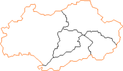
Gwangju is divided into 5 districts ("Gu").
| Map | Name | Hangul | Hanja | |
|---|---|---|---|---|
|
Buk-gu
Dong-gu
Gwangsan-gu
Nam-gu
Seo-gu
|
||||
| Gu (Districts) | ||||
| Buk-gu | 북구 | 北區 | ||
| Dong-gu | 동구 | 東區 | ||
| Gwangsan-gu | 광산구 | 光山區 | ||
| Nam-gu | 남구 | 南區 | ||
| Seo-gu | 서구 | 西區 | ||
Amenities
Areas of exquisite scenery along the outskirts of the city gave birth to gasa, a form of Korean classical poetry. Located in the heart of the agricultural Jeolla region, the city is also famous for its rich and diverse cuisine.
Transportation
Gwangju has one subway line. An extension to the line was completed in April 2008. There are also two KTX (high speed rail) stations in the city: Gwangju Station and Songjeong-ri Station. Songjeong-ri has been connected to the subway network; however, no connection exists to Gwangju Station.
Gwangju Airport and Muan International Airport serve Gwangju.
Climate
| Climate data for Gwangju, South Korea (1971–2000) | |||||||||||||
|---|---|---|---|---|---|---|---|---|---|---|---|---|---|
| Month | Jan | Feb | Mar | Apr | May | Jun | Jul | Aug | Sep | Oct | Nov | Dec | Year |
| Average high °C (°F) | 5.1 (41.2) |
7.0 (44.6) |
12.4 (54.3) |
19.3 (66.7) |
23.9 (75) |
27.2 (81) |
29.7 (85.5) |
30.5 (86.9) |
26.6 (79.9) |
21.5 (70.7) |
14.3 (57.7) |
8.0 (46.4) |
18.8 (65.8) |
| Daily mean °C (°F) | 0.5 (32.9) |
1.9 (35.4) |
6.5 (43.7) |
12.9 (55.2) |
17.8 (64) |
22.0 (71.6) |
25.5 (77.9) |
26.1 (79) |
21.4 (70.5) |
15.4 (59.7) |
8.7 (47.7) |
2.8 (37) |
13.5 (56.3) |
| Average low °C (°F) | -3.3 (26.1) |
-2.3 (27.9) |
1.6 (34.9) |
7.3 (45.1) |
12.4 (54.3) |
17.8 (64) |
22.4 (72.3) |
22.6 (72.7) |
17.2 (63) |
10.3 (50.5) |
4.2 (39.6) |
-1.2 (29.8) |
9.1 (48.4) |
| Precipitation mm (inches) | 38.0 (1.496) |
43.9 (1.728) |
64.5 (2.539) |
95.3 (3.752) |
97.3 (3.831) |
190.3 (7.492) |
281.9 (11.098) |
276.0 (10.866) |
137.7 (5.421) |
55.3 (2.177) |
55.4 (2.181) |
32.4 (1.276) |
1,367.8 (53.85) |
| % Humidity | 70.5 | 68.9 | 66.2 | 65.2 | 68.4 | 75.1 | 80.6 | 79.0 | 75.8 | 71.0 | 71.6 | 71.7 | 72.0 |
| Sunshine hours | 162.1 | 164.9 | 197.9 | 216.8 | 232.1 | 177.4 | 163.1 | 188.2 | 181.8 | 205.9 | 163.7 | 160.0 | 2,213.9 |
| Source: [1] | |||||||||||||
Education
Chonnam National University, Chosun University, Honam University and Gwangju University are the major educational institutions in the city, with several other universities and colleges also located in the region.
- Gwangju Institute of Science and Technology
Sister cities
 Guangzhou, China
 San Antonio, United States [1]
 Sendai, Japan [2]
 Tainan City, Taiwan
 Hobart, Australia
 Medan, Indonesia [3]
 Maceio, Brazil
Independent cities in South Korea
See also
- Gwangju Biennale
- Gwangju National Museum
- Gwangju Democratization Movement
- List of Korea-related topics
- List of cities in South Korea
References
- ↑ "평년값(30년 평균) 자료". Korea Meteorological Administration. http://www.kma.go.kr/sfc/sfc_03_05.jsp.
External links
- Official website of Gwangju
- The May 18 Memorial Foundation
- Gwangju :Official Site of Korea Tourism Org
|
|||||
|
||||||||||||||||||||
|
|||||||||||||||||||


