Grindelwald
| Grindelwald | ||||||||||
|---|---|---|---|---|---|---|---|---|---|---|
 |
||||||||||
|
||||||||||
| Population | 3,860 (Dec 2009)[1] | |||||||||
| - Density | 23 /km2 (58 /sq mi) | |||||||||
| Area | 171.1 km2 (66.1 sq mi) | |||||||||
| Elevation | 1,034 m (3,392 ft) | |||||||||
| Postal code | 3818 | |||||||||
| SFOS number | 0576 | |||||||||
| Mayor | Emanuel Schläppi | |||||||||
| Localities | Alpiglen, Grund, Itramen, Mühlebach, Schwendi, Tschingelberg, Wargistal | |||||||||
| Surrounded by | Brienz, Brienzwiler, Fieschertal (VS), Guttannen, Innertkirchen, Iseltwald, Lauterbrunnen, Lütschental, Meiringen, Schattenhalb | |||||||||
| Twin towns | Azumi, now Matsumoto (Japan) | |||||||||
| Website | www.grindelwald.com SFSO statistics |
|||||||||
 Grindelwald
|
||||||||||
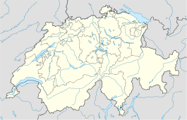
| View map of Grindelwald | ||||||||||
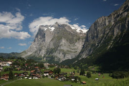
Grindelwald is a municipality in the Interlaken-Oberhasli administrative district in the canton of Bern in Switzerland. The village is located at 1,034 metres (3,392 ft) above sea level in the Bernese Alps.
Contents |
Winter sports
Long famed as a winter tourist destination with slopes for beginners, intermediates and the challenges of the Eiger glacier for the experienced, there are activities for the non-skiers, from tobogganing to groomed winter hiking tracks. It is the usual starting point for ascents of the Eiger and the Wetterhorn. Nowadays Grindelwald is also a popular summer activity resort with many miles of hiking trails across the Alps.
Geography
Grindelwald has an area, as of 2009[update], of 171.08 square kilometers (66.1 sq mi). Of this area, 49.47 square kilometers (19.1 sq mi) or 28.9% is used for agricultural purposes, while 28.02 square kilometers (10.8 sq mi) or 16.4% is forested. Of the rest of the land, 3.06 square kilometers (1.2 sq mi) or 1.8% is settled (buildings or roads), 1.37 square kilometers (0.5 sq mi) or 0.8% is either rivers or lakes and 89.21 square kilometers (34.4 sq mi) or 52.1% is unproductive land.[2]
Of the built up area, housing and buildings made up 1.0% and transportation infrastructure made up 0.6%. 12.9% of the total land area is heavily forested and 2.3% is covered with orchards or small clusters of trees. Of the agricultural land, 5.1% is pastures and 23.8% is used for alpine pastures. All the water in the municipality is in rivers and streams. Of the unproductive areas, 6.6% is unproductive vegetation, 24.0% is too rocky for vegetation and 21.6% of the land is covered by glaciers.[2]
The municipality is quite large and is divided into seven mountain communities. However the municipality is dominated by the large village and tourist center of Grindelwald.
History
Grindelwald is first mentioned in 1146 as Grindelwalt.[3]
Demographics

Grindelwald has a population (as of 31 December 2009) of 3,860.[1] As of 2007[update], 15.8% of the population was made up of foreign nationals. Over the last 10 years the population has decreased by 3.4%. Most of the population (as of 2000[update]) speaks German (86.8%), with Portuguese being second most common (4.5%) and French being third (1.7%).
In the 2007 election the most popular party was the SVP which received 54.8% of the vote. The next three most popular parties were the FDP (14.2%), the Green Party (10.1%) and the SPS (8.6%).
The age distribution of the population (as of 2000[update]) is children and teenagers (0–19 years old) make up 21.1% of the population, while adults (20–64 years old) make up 62.6% and seniors (over 64 years old) make up 16.3%. The entire Swiss population is generally well educated. In Grindelwald about 66.8% of the population (between age 25-64) have completed either non-mandatory upper secondary education or additional higher education (either University or a Fachhochschule).
Grindelwald has an unemployment rate of 2.66%. As of 2005[update], there were 365 people employed in the primary economic sector and about 138 businesses involved in this sector. 378 people are employed in the secondary sector and there are 53 businesses in this sector. 1,961 people are employed in the tertiary sector, with 225 businesses in this sector.[4]

The historical population is given in the following table:[3]
| year | population |
|---|---|
| 1764 | 1,816 |
| 1850 | 2,924 |
| 1900 | 3,346 |
| 1920 | 2,998 |
| 1950 | 3,053 |
| 2000 | 4,069 |
Transportation

| WAB Grindelwald to Kleine Scheidegg | ||||||||||||||||||||||||||||||||||||||||||||||||||||||||||||||||||||||||||||||||||||||||||||||||||||||||
|---|---|---|---|---|---|---|---|---|---|---|---|---|---|---|---|---|---|---|---|---|---|---|---|---|---|---|---|---|---|---|---|---|---|---|---|---|---|---|---|---|---|---|---|---|---|---|---|---|---|---|---|---|---|---|---|---|---|---|---|---|---|---|---|---|---|---|---|---|---|---|---|---|---|---|---|---|---|---|---|---|---|---|---|---|---|---|---|---|---|---|---|---|---|---|---|---|---|---|---|---|---|---|---|---|
|
||||||||||||||||||||||||||||||||||||||||||||||||||||||||||||||||||||||||||||||||||||||||||||||||||||||||
Grindelwald can be reached by train (Berner Oberland Bahn) from Interlaken.
The Wengernalpbahn connects Grindelwald to the Kleine Scheidegg from where the Jungfraubahn ascends inside the Eiger to the Jungfraujoch and trains descend to Wengen.
The Gondelbahn Grindelwald-Männlichen connects Grindelwald with the Männlichen and with onward travel on the Luftseilbahn Wengen-Männlichen offers an alternative route to Wengen.
The minor summit of First is accessible by ski lift from Grindelwald.
In the media
Many scenes of the documentary film The Alps were shot in the region of Grindelwald, particularly on the north face of the Eiger. The James Bond film, On Her Majesty's Secret Service includes a chase through a skating rink and Christmas festival in Grindelwald.[5] Grindelwald's mountains were used as the basis for the view of Alderaan in Star Wars Episode III: Revenge of the Sith.[6] Some of the action scenes in The Golden Compass were also shot in Grindelwald.[7]JK Rowling is said to have used the name of 'Grindelwald' in the creation of her character; Gellert Grindelwald, in the Harry Potter novels. There is a poster for Grindelwald on the gym wall in the Hogan's Heroes episode 'How's the Weather?" Grindelwald was a track in Gran Turismo 2.
Famous residents
- Richard Wagner
- Martina Schild, alpine skier, runner-up in the 2006 Winter Olympics women's downhill race
- Hedy Schlunegger, Olympic champion 1948 in downhill skiing
- Oleg Protopopov and Ludmila Belousova, 1964 and 1968 Olympic figure skating champions
See also
References
- ↑ 1.0 1.1 Swiss Federal Statistical Office, MS Excel document – Bilanz der ständigen Wohnbevölkerung nach Kantonen, Bezirken und Gemeinden (German) accessed 25 August 2010
- ↑ 2.0 2.1 Swiss Federal Statistical Office-Land Use Statistics 2009 data (German) accessed 25 March 2010
- ↑ 3.0 3.1 Grindelwald in German, French and Italian in the online Historical Dictionary of Switzerland.
- ↑ Swiss Federal Statistical Office accessed 12-Jun-2009
- ↑ IMDB-On Her Majesty's Secret Service
- ↑ IMDB-Star Wars Episode III: Revenge of the Sith
- ↑ IMDB-The Golden Compass
External links
- Grindelwald official website
- Webcams
- Grindelwald in German, French and Italian in the online Historical Dictionary of Switzerland.
|
|||||||
