Dharamsala
| Dharamshala | |||||
| — town — | |||||
|
|
|||||
| Coordinates | |||||
| Country | |||||
| State | Himachal Pradesh | ||||
| District(s) | Kangra | ||||
| Population • Density |
19,124 (2001[update]) • 659 /km2 (1,707 /sq mi) |
||||
| Time zone | IST (UTC+5:30) | ||||
| Area |
29 km2 (11 sq mi) • 1,457 metres (4,780 ft) |
||||
|
Codes
|
|||||


Dharamshala or Dharamsala (Hindi: धर्मशाला, pronounced [dʱərəmˈʃaːlaː] or [dʱərmˈʃaːlaː]; Tibetan: དྷ་རམ་ས་ལ་) is a city in northern India. It is the winter seat of government of the state of Himachal Pradesh and the district headquarters of the Kangra district.
Mcleod Ganj, a village within Dharamshala municipality, is the home of the Dalai Lama and the exiled Tibetan government.
Contents |
Description
Dharamshala is a city in the upper reaches of the Kangra Valley and is surrounded by dense coniferous forest consisting mainly of stately Deodars. The suburbs of the town includes -- McLeod Ganj, Bhagsu Nath, Forsyth Ganj, Naddi, Kotwali Bazaar (the main market of the town), Kaccheri area (government offices such as the court, police, post etc.), Sidhpur and Sidhbari (where the Karmapa Lama is based
The village of McLeod Ganj lying in the upper reaches is known worldwide for the presence of the Dalai Lama, where he has resided since fleeing Tibet in 1959. Dharamshala houses the headquarters of the Tibetan Government-in-exile about two kilometres below the town of McLeod Ganj, led by the Prime Minister, Samdhong Rinpoche.
Dharamshala is the centre of the Tibetan exile world in India. Following the 1959 Tibetan uprising there was an influx of Tibetan refugees who followed the Dalai Lama. His presence and the Tibetan population has made Dharamshala a popular destination for Indian and foreign tourists, including students studying Tibet.
Name
Meaning and Origin
"Dharamshala" (Devanagari: धर्मशाला; ITRANS: Dharmashaalaa; IAST: Dharmaśālā) is a Hindi word (derived from Sanskrit) that is a compound of dharma (धर्म) and shālā (शाला). An approximate translation into English would be 'spiritual dwelling' or, more loosely, 'sanctuary'. Rendering a precise literal translation into English is problematic due to the vast and conceptually rich semantic field of the word dharma,[1] and the cultural aspect of India.
In common Hindi usage, the word dharamshala refers to a shelter or rest house for spiritual pilgrims. Traditionally, such dharamshalas (pilgrims' rest houses) were commonly constructed near pilgrimage destinations (often located in remote areas) to give visitors a place to sleep for the night. When the first permanent settlement was created in the place now called Dharamshala, there was already one such pilgrims' rest house existing on the site, and the settlement took its name from that dharamshala.[2]
Transcription and Pronunciation
Due to a lack of uniform observance of transliteration and transcription conventions for Hindi (and the Devanagari script in which Hindi is written), the name of the town has been transcribed into English (and other languages using Romanic scripts) variously as Dharamshala, Dharamsala and, less frequently, Dharmshala and Dharmsala.[3] These four permutations result from two variables: the transcription of the word धर्म (dharma)—particularly the second syllable (र्म)—and that of the third syllable (शा).
A strict transliteration of धर्म as written would be 'dharma' [ˈdʱərma]. In the modern spoken Hindi of the region, however, there is a common metathesis in which the vowel and consonant sounds in the second syllable of certain words (including धर्म) are transposed, which changes 'dharma' to 'dharam' (pronounced somewhere between [ˈdʱərəm] and [ˈdʱərm], depending on the speaker). Thus, if the goal of the transcription is phonetic accord with modern spoken Hindi, then 'dharam' and 'dharm' are both legitimate options.
Regarding the third syllable, the Devanagari श corresponds to the English voiceless postalveolar fricative sh sound (IPA: [ʃ]; ITRANS: sh; IAST: ś), like the 'sh' in 'shirt', and not the s sound (/s/) like the 's' in 'song'. Thus, शाला is transcribed with the greatest phonetic accuracy in English as 'shala' (ITRANS: shaalaa; IAST: śālā). The less-common 'sala' variant is inaccurate in terms of both transliteration and pronunciation.
Therefore, the most accurate phonetic transcription of the Hindi धर्मशाला into Roman script for common (non-technical) English usage is either 'Dharamshala' or, less commonly, 'Dharmshala',[4] both of which render the sh (/ʃ/) sound of श in English as 'sh' to convey the correct native pronunciation, 'Dharamshala' [dʱərəmˈʃaːlaː] or 'Dharmshala' [dʱərmˈʃaːlaː]). Nonetheless, the alternate spelling 'Dharamsala' continues to be used in some cases despite its inaccuracy, and all four spelling permutations can be found in the English language materials of the local and state governments, in publications, and on the Internet.[5]
Regardless of spelling variations, however, it should be clear to the reader that the correct native pronunciation is with the sh sound (/ʃ/).[6]
In actual practice, the spelling variant that is most common and most concordant with standards of transcription and native pronunciation is 'Dharamshala'.[7]
The most important aspect of the spelling is that officially in Indian English it is Dharamshala: just as the spelling of Simla in Indian English has officially been changed to Shimla, Dharamshala was made the official spelling many years ago.
Demographics
As of the 2001[update] India census,[8] Dharamshala had a population of 19,124. Males constitute 55% of the population and females 45%. Dharamshala has an average literacy rate of 77%, higher than the national average of 59.5%: male literacy is 80% and, female literacy is 73%. In Dharamshala, 9% of the population is under 6 years of age.
As of Census of India 2001[9]
Number of Households - 4,342
Average Household Size(per Household) - 4.0
Population-Total - 19,124
Population-Urban - 19,124
Proportion of Urban Population (%) - 100
Population-Rural - 0
Sex Ratio - 824
Population(0-6Years) - 1,819
Sex Ratio(0-6 Year) - 913
SC Population - 2,611
Sex Ratio (SC) - 861
Proportion of SC (%) - 14.0
ST Population - 99
Sex Ratio (ST) - 833
Proportion of ST (%) - 1
Literates - 14,462
Illiterates - 4,662
Literacy Rate (%) - 77.0
Geography

Dharamshala has an average elevation of 1457 metres (4780 feet). The area covered by Dharamshala is almost 29 km².
Dharamshala is located in the Kangra Valley, in the Dhauladhar mountains, and became the capital of the Kangra District in 1852. It is accessible from Pathankot which is 120 km away. The nearest railway connection to Dharamshala is Kangra. The nearest airport is Gaggal at Kangra, which is just 15 km away. There is a daily flight from Dharamshala to Delhi.
The town is divided between McLeodGanj or Upper Dharamshala (which retains a British colonial atmosphere), and Lower Dharamshala (the commercial centre). Upper Dharamshala (elevation about 1,700 m or 5,580 ft) is about 9 kilometers (5.6 miles) from Lower Dharamshala by road and is some 460 m (1,510 ft) higher.
Dhauladhar means "white ridge" and this breathtaking, snow-capped range rises out of the Kangra Valley to a height of 17,000 feet. They form a treacherous range creating unpredictable weather, but passes of 8,900 feet provide route for the herdsmen of the Ravi Valley beyond. The Kangra Valley is a wide, fertile plain, criss-crossed by low hills.
Dharamsala is divided into two very different parts. Kotwali Bazaar and areas further down the valley are called Lower Dharamsala, while McLeod Ganj and surrounding areas are known as Upper Dharamsala. McLeodganj is nine km by bus route and four km by taxi route up the hill from Kotwali Bazaar. While inhabitants of Lower Dharamsala are almost all Indians, McLeod Ganj is primarily a Tibetan area. McLeod Ganj is surrounded by pine, Himalayan oak, and rhododendron. The main crops grown by local Indians in the valleys below McLeod Ganj are rice, wheat and tea.
Connections
- The nearest airport is Gaggal Airport, an hour's drive from Dharamshala.
- Air-conditioned, deluxe buses ply between Dharamsala and major cities such as Chandigarh, Delhi, and Shimla.
- The nearest broad gauge railway station is Chakki Bank at Pathankot, which is three hours from Dharamshala and is well connected to the rest of Northern India. There is another railway line from Pathankot to Jogindernagar, a part of the Mandi District of Himachal Pradesh, which is a narrow-gauge line, the nearest station to Dharamshala on this line is Chamunda Marg, half an hour away, where a famous Shaktipitha is located; the town is also well connected by road to other parts of the country.
Pathankot city is known as the gateway to Himachal Pradesh & Jammu and Kashmir. Pathankot is well connected by Air & Train and has big military base.
Dharamshala is the nearest tourist hill station to Delhi. It is aprrox 95 km from Pathankot. One can easily visit Dharamshala from Pathankot or Chakki bank railway station. Nearest Airports are Gaggal & Pathankot. While starting for Dharamshala the Kandwal barrier is there to check all the cabs & other tax formalities.
Climate
| Dharamsala | ||||||||||||||||||||||||||||||||||||||||||||||||||||||||||||
|---|---|---|---|---|---|---|---|---|---|---|---|---|---|---|---|---|---|---|---|---|---|---|---|---|---|---|---|---|---|---|---|---|---|---|---|---|---|---|---|---|---|---|---|---|---|---|---|---|---|---|---|---|---|---|---|---|---|---|---|---|
| Climate chart () | ||||||||||||||||||||||||||||||||||||||||||||||||||||||||||||
|
||||||||||||||||||||||||||||||||||||||||||||||||||||||||||||
|
||||||||||||||||||||||||||||||||||||||||||||||||||||||||||||
Dharamshala has a monsoon-influenced Alpine climate. Summer starts in early April and peaks in early June, when temperatures can reach 35oC. From July to September, in the monsoon season, up to 2000 mm (79 inches) of rain can fall, making Dharamshala one of the wettest places in the state. The monsoon ends in late September and is followed by autumn.
Autumn lasts till late November, with temperatures averaging around 14-15oC. Winter starts in December and goes on till late February. Snow and sleet is common during the winter. Winter is followed by a short, pleasant spring till April.
The best time to visit are the autumn and spring months.
History
Before the Raj
From the earliest times until the British Raj, Dharamshala and its surrounding area was ruled by the Katoch Dynasty of Kangra. The Katoch Dynasty is said to be the oldest serving Royal Family in the world. The Royal Family still keeps a residance in Dharamshala, known as 'Clouds End Villa'.
The indigenous people of the Dharamshala area (and the surrounding region) are the Gaddis, a predominantly Hindu group who traditionally lived a nomadic or semi-nomadic (transhumant) lifestyle. Due to the lack of permanent settlements in the area, some Gaddis lost their seasonal pastures and farmland when the British and the Gurkhas arrived to settle.
Settlement by the British and the Gurkhas
In 1848, the area now known as Dharamshala was annexed by the British.
- "Dharamsāla lies on a spur of the Dhaola Dhār, 16 miles north-east of Kāngra, in the midst of wild and picturesque scenery. It originally formed a subsidiary cantonment for the troops stationed at Kāngra, and was first occupied as a station in 1849, when a site was required for a cantonment to accommodate a Native regiment which was being raised in the District. A site was found upon the slopes of the Dhaola Dhār, in a plot of waste land, upon which stood an old Hindu resthouse, or dharmsāla, whence the name adopted for the new cantonment. The civil authorities, following the example of the regimental officers, and attracted by the advantages of climate and scenery, built themselves houses in the neighbourhood of the cantonment; and in 1855 the new station was formally recognised as the head-quarters of the [Kāngra] District."[10]
In 1860, the 66th Gurkha Light Infantry was moved from Kangra to Dharamshala, which was at first made a subsidiary cantonment. An ideal position for the new base was found on the slopes of the Dhauladhar Hills, near the site of a Hindu sanctuary, or Dharamshala, hence the name of the town.[11][12] The Battalion was later renamed the historic 1st Gurkha Rifles, this was the beginning of the legend of the world-famous Gurkhas the so-called 'Bravest of the Brave'. Consequently, fourteen Gurkha platoon villages grew from this settlement, and exist to this day, namely Dari, Ramnagar, Shyamnagar, Dal, Totarani, Khanyara, Sadher, Chaandmaari, Sallagarhi, Sidhbari, Yol, and so on. The Gurkhas worshipped at the ancient Shiva temple of Bhagsunag. The Gurkhas referred to Dharamshala as 'Bhagsu' and referred to themselves as Bhagsuwalas.
The 21st Gurkha Regiment from Dharamshala performed heroic feats during World War I and the North West Frontier Province campaigns. The Gurkha cantonment then reached its zenith during World War II, when battalions from Dharamshala made history. Many place names in the town still retain their former cantonment terminologies: Depot Bazaar, Pensioners' Lines, Tirah Lines (named after the 19th century Tirah Campaign), Bharatpore Lines (named after the 1826 Battle of Bharatpore).
The second Lord Elgin, Viceroy of India died here (at the 1st Gurkha Rifles Officers' Mess) in 1863 and is buried in the cemetery of St. John in the Wilderness, a small Anglican church distinguished by its stained-glass windows. Dharamshala became a popular hill station for the British working in or near Delhi, offering a cool respite during the hot summer months.
- "Before the earthquake of 1905, the upper part of the station, which rises to a height of 7,112 feet [2,168 metres], contained the European houses, the station church, and the officers' mess and lines of the 1st Gurkhas, together with the public gardens, post office, and two bazars, the Forsythganj and McLeodganj. The public offices, a bazar, and a few European houses made up the lower station, as low as 4,500 feet [1,372 metres]. The 1st battalion of the 1st Gurkhas used to be stationed here, but was moved to the upper station in 1894-5.... The public gardens, which were, before the earthquake, laid out with much taste in lawns and terraces, contained a valuable collection of indigenous and imported trees and shrubs, and were overlooked by the Assembly Rooms, a handsome building comprising a public hall, a library and reading-room and a billiard-room. The church was beautifully situated in a recess of the mountain."[13]
In 1905, the Kangra valley suffered a major earthquake. On April 4 of that year, the earth shook, demolishing much of the cantonment and the neighbouring city of Kangra as well as the Bhagsunag temple. Altogether, the 1905 Kangra earthquake killed 20,000 people. "1,625 persons perished at Dharamsāla alone, including 15 Europeans and 112 of the Gurkha garrison."."[14]
The Gurkhas rebuilt the town along with the temple, which today is acknowledged as the 1st Gurkha Rifles' heritage. The British had planned to make Dharamshala the summer capital of India, but moved to Shimla after the disaster.
Not only did the Gurkhas of Dharmshala make a major contribution to India's defence but also many were freedom fighters for the Indian National Army, which had been founded by Netaji Subhas Chandra Bose. The Indian National Army Captain Ram Singh Thakur, a Gurkha from the village of Khanyara, composed some of India's most popular and stirring patriotic songs, including "Kadam Kadam Badaye Ja". He is acknowledged so by the Netaji Research Bureau, Kolkata. The important contribution of the noted Gurkha social commentator, the late Master Mitrasen Thapa, from the village of Totarani, has also been acknowledged by the Himachal Pradesh government. Recently, a park dedicated to the memory of the late Brigadier Sher Jung Thapa, MVC, the 'Hero of Skardu', has been opened alongside the road between Lower and Upper Dharamshala.
Establishment of Tibetan exile community

The Tibetan settlement of Dharamshala began in 1959, when His Holiness the Dalai Lama had to flee Tibet and the Prime Minister of India allowed him and his followers to settle in McLeodGanj (in Upper Dharmshala), a former colonial British summer picnic spot. There they established the "government-in-exile" in 1960. Dharamshala had been connected with Hinduism and Buddhism for a long time, many monasteries having been established there in the past, by Tibetan immigrants in the 19th century.

In 1970, The Dalai Lama, Tenzin Gyatso, opened the Library of Tibetan Works and Archives which houses over 80,000 manuscripts and other important resources related to Tibetan history, politics and culture. It is considered one of the most important institutions for Tibetology in the world,[www.ltwa.net]; the new director is Geshe Lahkdor, the old translator of H.H. the Dalai Lama.
Dharamshala Today
Several thousand Tibetan exiles have now settled in the area, and most live in and around McLeod Ganj in Upper Dharamshala, where they have built monasteries, temples and schools. McLeodGanj is sometimes known as 'Little Lhasa", after the Tibetan capital city, or 'Dhasa' (a compound of 'Dharamshala' and 'Lhasa'). It has become an important tourist destination with many hotels and restaurants, leading to growth in tourism and commerce.
Dharamshala is also the winter capital of Himachal Pradesh. The Secretariat is at Sidhbari, near the Chinmaya Tapovan Ashram, and the winter sessions of the Government are held there.
Notable residents
- Tenzin Gyatso, 14th and current Dalai Lama
- H.H The Maharaja of Kangra, 488th Raja of Trigarta. Maharaja Aditya Katoch and his wife Maharani Chandresh Kumari {Member of Parliament} princess of Jodhpur
- Namrata Singh Gujral, Hollywood Actress
- Palden Gyatso, monk, international speaker, author of Fire Under the Snow and subject of the film of the same name (2008)
- Passang Lhamo, nun and activist, and former inmate of Drapchi Prison
- James Bruce, 8th Earl of Elgin, died here.
- Tenzin Dolma, Miss Tibet 2007
- Alfred W. Hallett. Artist who exhibited twice in Royal Academy of Arts London and lived 41 years at Dharamkot in upper Dharamshala died here in 1986.
Trekking
Dharamshala is a starting point to a number of trekking trails that especially lead trekkers across Dhauladhar into the upper Ravi Valley and Chamba district. En route, you cross through forests of deodar, pine, oak and rhododendron, and pass streams and rivers and wind along vertiginous cliff tracks, and also the occasional lake waterfall and glacier.
A 2-km amble takes one to Bhagsu, and then a further 3-km walk will lead the trekkers to Dharamkot. If one wishes to go on a longer walk then he/she can trek 8-km to Triund. The snow line of Ilaqa Got is just a 5-km walk.
Other trekking trails that lead you to Chamba from Dharamshala are:
• Toral Pass (4575m) which begins from Tang Narwana (1150m) that is located nearly 10 km from Dharamshala
• Across Bhimghasutri Pass (4580m) via near-vertical rocky ascents, steep cliffs and dangerous gorges. This is a highly difficult level trek and takes around six days to complete.
• Dharamshala—Bleni Pass (3710m) – Dunali. Compared to other trekking trails, this one is much easier and takes around four or five-days to complete. The trek leads you through alpine pastures, woods, and streams, before ending at Dunali, on the Chamba road.
Also, Dharamshala is an ideal destination for rock climbing enthusiasts. One can go rock climbing over the ridges of the Dhauladhar range.
Dharamshala Cricket Stadium

Dharamshala Cricket Stadium (DCS) is a cricket stadium of international reputation, which serves as the home ground to the Himachal Pradesh state cricket team and also for the IPL team Kings XI Punjab to a limited extent. By virtue of its natural backdrop, it is one of the most attractive cricket stadiums in India. In addition to Ranji matches, some international matches are also planned to be held here.Recently a match between Kings XI Punjab and Chennai Superkings held here in which His Holiness the Dalai Lama graced the match of the Indian Premier League (IPL) at the picturesque Himachal Pradesh Cricket Stadium in Dharamsala[15] The snow capped mountains can be easily viewed throughout the year. An additional feature is the Dharamsala College nearby which is surrounded by pine trees on one side.
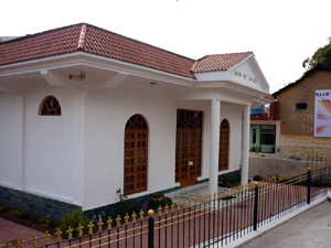
Naam Art Gallery
Location:Sidhbari (Chamunda road)
The permanent exhibition in ‘NAAM ART GALLERY’ shows paintings by Elsbeth Buschmann - watercolours and acrylics - and oil paintings by Alfred W. Hallett.
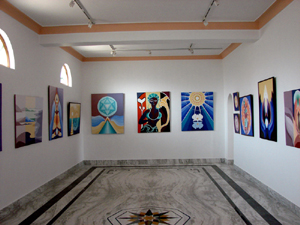
Elsbeth Buschmann, is a professional painter from Germany, having studied painting in London and Paris .She lived in many countries where she held exhibitions, especially in the USA where she received various awards. Her paintings are in private collections in Germany, USA, Scotland, India and Switzerland. In India she held solo exhibitions at AIFAX, New Delhi and TAG, the Art Gallery of the Taj Mahal Hotel, Mumbai. She also took part in ‘The Himalayan National Exhibition of Art’ and was awarded.
Alfred Hallett is a very well renowned painter from England. He studied art in London and participated in two exhibitions of the Royal Academy of Art, London which entitled him to become a Fellow of the Academy. He held various international exhibitions. He lived over 40 years at Dharamsala and became very popular in Himachal Pradesh. Many of his paintings are owned by the government of Himachal Pradesh. A. W. Hallett held a special interest in the culture and scenery of Himachal Pradesh which are the main elements of his work. He died in 1986 at Dharamsala. The display of his paintings in ‘NAAM ART GALLERY’ are a tribute to this great painter.Gallery Timing: 10 am to 7 pm (Monday closed)
Masrur (or Masroor): The major attraction of this place is the fifteen exquisitely carved monolithic rock temples dating back to 8th century. The carvings of these temples are similar to Kailash temple at Ellora. In the sanctum of the main temple, one can find images of Lord Ram, and the Goddesses Sita and Lakshmi. Masrur is located 15 km south of Kangra at .
Bhagsu Waterfall: This waterfall is situated at Bhagsu, 2 km from McLeodganj. It lies behind the Bhagsunag Temple. During Monsoon, the fall turns into a 30 feet cascade.
Bhagsunag Temple: Temple of god Shiva situated around 2 km from McLeodganj Bazaar. Constructed by 1 GR by around 1800 century and then worshipped majorly by 14 Gukha platoon villages in Dharamshala. Very next to Bhagsunag temple is a water fall, one of the major tourist attraction spot in Dharamshala.
Kunal Parthi Temple: This temple is dedicated to Goddess Kalpeshwari, and is located 3 km from the Kotwali Bazaar. It's a believed that a part of Goddess Sati, skull, fell here when Lord Shiva was carrying the charred body of the Goddess, and hence the name of the temple.
Chamunda Temple: This temple is located around 15 km from Dharamshala on the right bank of river Baner on the Mandi-Pathankot highway. According to mythology, Goddess Kali killed the demons Chand and Mund at this place.
Dal Lake: The Lake is spread in an area of 1 km and is bounded by rhododendrons, deodars, and junipers forest. Annually, a fair is held at the Kali Temple near the Lake. There is another temple close to the lake that is dedicated to sage Durvasa. Dal Lake is 2 km walk westwards from McLeod Ganj bazaar.
Triund: Triund is nestled in the foothills of Dhauladhar and is around 17 km from Dharamshala. It's a trekking destination from McLeod Ganj, and offers magnificent vistas of the mountains and valleys. The nightstays are in the hoods, small time caves, that local gaddis with their goat herds use as shelters from rains during the daytime.
Naddi: This scenic picnic spot is located 5 km northwest of McLeod Ganj. Naddi offers a spectacular view of the Kangra valley. You can trek to Kareri Lake, Triund, and Guna Devi from here. It's also becoming a popular destination for nature lovers.
Places of attraction
- Indrunag (The Best view of Dhauladhar Range)
- Adi Shakti Temple, Naddi
- Aghanjar Mahadev
- Bhagsu Waterfall
- Bhagsunath
- Bir paragliding spot
- Brajeshwari Temple
- Cafe Boom Boom the Fifth, popular restaurant with tourists
- Chamunda Mandir
- Chinmaya Tapovan
- Dal Lake
- Dari
- Dehra Gopipur
- Dharamkot (2100 m)
- Golf Course (Yol Cantt.)
- Guna Devi Mandir amidst of dense forest
- Historical fort of Kangra in Purana Kangra
- Haripur Village (near Guler)
- Pong Dam Lake
- Indru Nag Temple
- Kareri Lake
- KhanaNirvana Community Café, a popular restaurant and event venue[16]
- Khaniyara
- Kunal Pathri
- Lam Dal Lake
- Library of Tibetan Works and Archives
- Masrur (rock temple)
- Namgyal Monastery
- Narghota
- Norbulingka Institute
- Nurpur[17]
- Sidhbari
- Pizzicato Cafe, Palampur (famous for its dark choc pastry)
- Church of St. John in the Wilderness
- Tibetan Institute of Performing Arts
- Triund (2975 m), a popular day hike or overnight trek
- Tatwani and Machhrial
- Trilokpur
- Waterfall at Bhagsunath
Gallery
.jpg) Shakyamuni Buddha at the monastery of the Dalai Lama, Tenzin Gyatso. |
 Prayer Drums, Dharamshala |
 Mules carrying locally mined slate, a material used on most roofs in the area. |
 Stupa & prayer wheels. Main street, McLeod Ganj, 2004 |
|
View outside the valley at Dharamshala |
 A collection of Buddhism's teachings in Dharamshala, India. |
References
- ↑ Dharma#Etymology
- ↑ http://dsal.uchicago.edu/reference/gazetteer/pager.html?objectid=DS405.1.I34_V11_307.gif
- ↑ Ref. http://dsal.uchicago.edu/reference/gazetteer/pager.html?objectid=DS405.1.I34_V11_307.gif
- ↑ Ref. Devanagari_transliteration#Consonants
- ↑ Ref. http://hptdc.nic.in/access.htm, which includes both common spellings on the same page.
- ↑ Ref. Devanagari_transliteration#Consonants
- ↑ Talk:Dharamsala#Propose_changing_spelling_of_article_title_from_.27Dharamsala.27_to_.27Dharamshala.27
- ↑ "Census of India 2001: Data from the 2001 Census, including cities, villages and towns (Provisional)". Census Commission of India. Archived from the original on 2004-06-16. http://web.archive.org/web/20040616075334/http://www.censusindia.net/results/town.php?stad=A&state5=999. Retrieved 2008-11-01.
- ↑ Census of India
- ↑ Imperial Gazetteer of India (1908), Vol. II, p. 301.
- ↑ www.mcllo.com A Non-Profit Informative, Travel and Community website of Dharamsala, Mcleodganj and Kangra Valley
- ↑ Dharamshala The Imperial Gazetteer of India, v. 11, p. 301.
- ↑ Imperial Gazetteer of India (1908), Vol. II, pp. 301-302.
- ↑ Imperial Gazetteer of India (1908), Vol. II, p. 302.
- ↑ http://himachal.us/2007/11/15/cricket-ground-dharamsala/3611/media/photo-news/rsood
- ↑ http://us.ft.com/ftgateway/superpage.ft?news_id=fto031020060703530321&page=2
- ↑ Himachal Pradesh Tourism Dep. Co.
- Verma, V. 1996. Gaddis of Dhauladhar: A Transhumant Tribe of the Himalayas. Indus Publishing Co., New Delhi.
- Handa, O. C. 1987. Buddhist Monasteries in Himachal Pradesh. Indus Publishing Co., New Delhi. ISBN 81-85182-03-5.