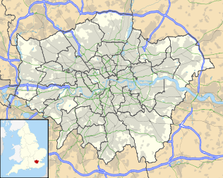
Bloomsbury
| Bloomsbury | |
 Bedford Square, one of Bloomsbury's garden squares |
|
 Bloomsbury
|
|
| OS grid reference | |
|---|---|
| London borough | Camden |
| Ceremonial county | Greater London |
| Region | London |
| Country | England |
| Sovereign state | United Kingdom |
| Post town | LONDON |
| Postcode district | WC1 |
| Dialling code | 020 |
| Police | Metropolitan |
| Fire | London |
| Ambulance | London |
| EU Parliament | London |
| UK Parliament | Holborn and St Pancras |
| London Assembly | Barnet and Camden |
| List of places: UK • England • London | |
Bloomsbury is an area of central London between Euston Road and Holborn, developed by the Russell family in the 17th and 18th centuries into a fashionable residential area. It is notable for its array of garden squares,[1] literary connections (exemplified by the Bloomsbury Group), and numerous hospitals and academic institutions.
While Bloomsbury was not the first area of London to have acquired a formal square, Bloomsbury Square, laid out in 1660 by Thomas Wriothesley, 4th Earl of Southampton as Southampton Square, was the first square to be named as such.[2]
Bloomsbury is home to the British Museum, the Royal Academy of Dramatic Art, and the British Medical Association. It is also home to the University of London's Senate House Library, its central departments (including the School of Advanced Study), and several of its colleges (University College London, Birkbeck, London School of Hygiene and Tropical Medicine, School of Pharmacy, School of Oriental and African Studies and the Royal Veterinary College).
Notable hospitals include Great Ormond Street Hospital, the National Hospital for Neurology and Neurosurgery, University College Hospital and the Royal London Homoeopathic Hospital. Bloomsbury was formerly home to the British Library, housed within the British Museum; the Library moved in 1997 to larger premises nearby, next to St Pancras railway station in Somers Town.
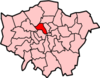
It comes under the authority of the London Borough of Camden, and is in the Parliamentary constituency of Holborn and St Pancras.
Contents |
History
The earliest record of what would become Bloomsbury is the 1086 Domesday Book, which records that the area had vineyards and "wood for 100 pigs".[2] But it is not until 1201 that the name Bloomsbury is first noted, when William de Blemond, a Norman landowner, acquired the land.[3] The name Bloomsbury is a development from Blemondisberi – the bury, or manor, of Blemond. An 1878 publication, Old and New London: Volume 4, mentions the idea that the area was named after a village called "Lomesbury" which formerly stood where Bloomsbury Square is now,[4] though this piece of folk etymology is now discredited.
At the end of the 14th century Edward III acquired Blemond's manor, and passed it on to the Carthusian monks of the London Charterhouse, who kept the area mostly rural.
In the 16th century, with the Dissolution of the Monasteries, Henry VIII took the land back into the possession of the Crown, and granted it to Thomas Wriothesley, 1st Earl of Southampton.
In the early 1660s, the Earl of Southampton constructed what eventually became Bloomsbury Square. The area was laid out mainly in the 18th century, largely by landowners such as Wriothesley Russell, 3rd Duke of Bedford, who built Bloomsbury Market, which opened in 1730. The major development of the squares that we see today started in about 1800 when Francis Russell, 5th Duke of Bedford removed Bedford House and developed the land to the north with Russell Square as its centrepiece.
Governance
William de Blemond in the 13th century, a Norman, was the first landowner. Edward III acquired Blemond's manor, and passed it on to the Carthusian monks who governed it until Henry VIII granted it to the Earl of Southampton. The Russell family became landowners in the 18th century.
The area lay within the parishes of St Giles in the Fields and St George's, Bloomsbury,[5] which were absorbed into the St Giles District as part of the Metropolis Management Act 1855.[6] It is now controlled by the London Borough of Camden, and is in the Parliamentary constituency of Holborn and St Pancras.
Geography

Bloomsbury has no official boundaries, but can be roughly defined as the square bounded by Gower Street and the lower part of Tottenham Court Road to the west, Euston Road to the north, Gray's Inn Road to the east, and either High Holborn or the thoroughfare formed by New Oxford Street, Bloomsbury Way and Theobalds Road to the south.[2] Bloomsbury merges gradually with Holborn in the south, and with St Pancras in the north-east and Clerkenwell in the south-east.
The area is bisected north to south by the main Southampton Row-Woburn Place thoroughfare, which contains several large tourist hotels and links Tavistock Square and Russell Square – the central points of Bloomsbury. The road runs from Euston and Somers Town in the north to Holborn in the south.
The area east of Southmpton Row/Woburn Place includes the Brunswick shopping centre and cinema,[7] and Coram's Fields recreation area. The area to the north of Coram's Fields consists mainly of blocks of flats, built both as private and social housing, and is generally considered part of St Pancras[8] or King's Cross[9] rather than north-eastern Bloomsbury. The area to the south is generally less residential, containing several hospitals, including Great Ormond Street, and gradually becomes more commercial in character as it approaches the boundary with Holborn at Theobalds Road.
The area west of Southampton Row/Woburn Place is notable for its concentration of academic establishments, museums, and formal squares. It is this side that contains the British Museum and the central departments and colleges of the University of London, including Birkbeck College, University College London, the School of Oriental and African Studies, and the University of London's School of Advanced Study. The main north-south road in west Bloomsbury is Gower Street which is a one-way road running south from Euston Road towards Shaftesbury Avenue in Covent Garden, becoming Bloomsbury Street when it passes to the west of the British Museum.
- Location in context
 |
Regent's Park | Somers Town | St Pancras | |
| Fitzrovia | Clerkenwell | |||
| Soho | Covent Garden | Holborn |
Parks and squares
Bloomsbury contains some of London's finest parks and buildings, and is particularly known for its formal squares. These include:

- Russell Square, a large and orderly square; its gardens were originally designed by Humphry Repton. The square is adjacent to the Russell Hotel and a short distance from Russell Square Tube Station.
- Bedford Square, built between 1775 and 1783, is still surrounded by Georgian town houses.
- Bloomsbury Square, a small circular garden, but called a square, is also surrounded by Georgian buildings including the former Victorian House and state home of the Lord Chancellor.
- Queen Square, home to many hospitals including the National Hospital for Neurology and Neurosurgery.
- Gordon Square, surrounded by the history and archaeology departments of University College London, as well as the former home of John Maynard Keynes, the famous economist.
- Woburn Square and Torrington Square, home to other parts of University College London.
- Tavistock Square, home to the British Medical Association; its eastern edge was the site of one of the 7 July 2005 London bombings.
- Mecklenburgh Square, east of Coram's Fields, one the few squares which remains locked for the use of local residents.
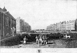
- Coram's Fields, a large recreational space on the eastern edge of the area, formerly home to the Foundling Hospital. It is only open to children and those adults accompanying children.
- Brunswick Square, now occupied by the School of Pharmacy and the Foundling Museum.
Culture

Historically, Bloomsbury is associated with the arts, education and medicine. The area gives its name to the Bloomsbury Group (also Bloomsbury Set) of artists, the most famous of whom was Virginia Woolf, who met in private homes in the area in the early 1900s,[10] and to the lesser known Bloomsbury Gang of Whigs formed in 1765 by John Russell, 4th Duke of Bedford. The publisher Faber & Faber is in Queen Square, though at the time when T. S. Eliot was editor the offices were in Tavistock Square. The Pre-Raphaelite Brotherhood was founded in John Millais' parents' house on Gower Street in 1848.
- Educational institutions
Bloomsbury is home to Senate House and the main library of the University of London, The Bloomsbury Colleges (Birkbeck, University of London, Institute of Education, London School of Hygiene and Tropical Medicine, School of Pharmacy, School of Oriental and African Studies and the Royal Veterinary College) and University College London (with the Slade School of Fine Art), the College of Law, London Contemporary Dance School, the Royal Academy of Dramatic Art, and Goodenough College. Other colleges in the area include the University of London's School of Advanced Study, the Architectural Association School of Architecture in Bedford Square, and several London campuses of American colleges including the University of California London Centre, University of Delaware London Centre, Huron University, Florida State University London Study Centre, and the Syracuse University London Facility.
- Museums
The British Museum, which first opened to the public in 1759 in Montagu House, is at the heart of Bloomsbury. At the centre of the museum around the former British Library Reading Room (where Karl Marx was a reader), the space formerly filled with the concrete storage bunkers of the British Library is today the Great Court, an indoor square with a glass roof designed by British architect Norman Foster. It houses displays, a cinema, a shop, a cafe and a restaurant. Since 1998, the British Library has been located in a purpose-built building just outside the northern edge of Bloomsbury, on Euston Road.
Also in Bloomsbury is the Foundling Museum close to Brunswick Square, which tells the story of the Foundling Hospital opened by Thomas Coram, for unwanted children (foundlings) in Georgian London. The hospital, now demolished but for the Georgian colonnade, is today a playground and outdoor sports field for children, called Coram’s Fields; adults are only admitted with a child. It is also home to a small number of sheep. The nearby Lamb’s Conduit Street is a pleasant thoroughfare with independent shops, cafes and restaurants.
There is also the Dickens Museum in Doughty Street, and the Petrie Museum and the Grant Museum of Zoology at University College London in Gower Street.
Hospitals
Great Ormond Street Hospital for children, is located just off Queen Square, which itself is home to the National Hospital for Neurology and Neurosurgery (formerly the National Hospital for Nervous Diseases) and the Royal London Homoeopathic Hospital. Bloomsbury is also the location of University College Hospital, which re-opened in 2005 in new buildings on Euston Road, built under the government’s Private Finance Initiative (PFI). The Eastman Dental Hospital is located on Gray’s Inn Road close to the Royal National Throat, Nose and Ear Hospital administered by the Royal Free Hampstead NHS Trust.
Business
In February 2010 businesses were balloted on an expansion of the InHolborn Business Improvement District (BID) to include the southern part of Bloomsbury. Only businesses with a rateable value in excess of £60,000 could vote as only these would pay the BID levy. This expansion of the BID into Bloomsbury was supported by Camden Council.[11] The proposal was passed and part of Bloomsbury was brought within the InHolborn BID [12]
Controversy was raised during this BID renewal when InHolborn proposed collecting Bloomsbury and the historic areas of St. Giles and Holborn under the name of "Midtown".[13][14][15]
Whilst businesses were informed about the BID proposals there was little consultation with residents or voluntary organisations. InHolborn produced a comprehensive business plan aimed at large businesses.[16]
Churches

Bloomsbury contains three notable churches. St. George's Church, located on Bloomsbury Way in the south of the area, was built by Nicholas Hawksmoor between 1716 and 1731. It has a deep Roman porch with six huge Corinthian columns, and is notable for its steeple based on the Tomb of Mausolus at Halicarnassus and for the statue of King George I on the top.
The second is the Early English Neo-Gothic Church of Christ the King on Gordon Square. It was designed for the Irvingites[17] by Raphael Brandon in 1853. Since June 10, 1954 it has been a Grade I listed building.
The third is St Pancras New Church on the northern boundary, near Euston station. This church was completed in 1822, and is notable for the caryatids on north and south which are based on the "porch of the maidens" from the Temple of the Erechtheum.
The church of St George the Martyr in Queen Square was built 1703–1706,[18] and was where Ted Hughes and Sylvia Plath married on Bloomsday in 1956.[19]
Transport
The area surrounding Bloomsbury is served by several London Underground stations, although only two of these (Russell Square and Euston Square) have entrances in Bloomsbury itself. The other stations, located on the fringes of Bloomsbury, are Euston, Goodge Street, Warren Street, Tottenham Court Road, Holborn, Chancery Lane and King's Cross St. Pancras.
The mainline rail stations Euston, King's Cross and St. Pancras are all located just north of Bloomsbury. Since Wednesday, November 14, 2007, Eurostar services have relocated to St Pancras, promising shorter journey times to Paris and Brussels and better connections to the rest of the UK.
Bloomsbury is also home to the disused British Museum tube station.
It is well served by buses, with over 12 different routes running south down Gower Street, and both north and south through Russell Square.[20] Route 7 goes along Great Russell Street, past the British Museum, and on to Russell Square.
One of the 13 surviving taxi driver's shelters in London is in Russell Square[21] where drivers can stop for a meal and a drink.
Notable residents
- Vanessa Bell (1879–1961), painter, sister of Virginia Woolf lived at 46 Gordon Square.
- William Copeland Borlase M.P. (1848–1899)
- Randolph Caldecott (1846–1886), illustrator, lived at No 46 Great Russell Street.
- Charles Darwin (1809–1882) lived at 12 Upper Gower St in 1839.[22]
- George Dance (1741–1825), architect lived at 91 Gower Street.
- Charles Dickens (1812–1870), novelist lived at 14 Great Russell Street, Tavistock Square and 48 Doughty Street.
- Philip (1792–1870) and Philip Charles Hardwick (1822–1892), father and son architects lived at 60 Russell Square for over ten years.
- John Maynard Keynes, lived for thirty years in Gordon Square.
- Bob Marley lived in 34 Ridgmount Gardens for 6 months in 1972.
- Dorothy L. Sayers (1893–1957) lived at 24 Great James Street from 1921–1929.
- John Shaw Senior (1776–1832) and John Shaw Junior (1803–1870), father and son architects lived in Gower Street.
- Catherine Tate (b.1968), actress and comedienne, was brought up in the Brunswick Centre, close to Russell Square.
- Virginia Woolf (1882–1941), author, essayist, and diarist resided at 46 Gordon Square.
- Thomas Henry Wyatt (1807–1880), architect lived at 77 Great Russell Street.
- William Butler Yeats (1865–1939), poet, dramatist and prose writer lived at Woburn Walk.
- Ricky Gervais, comedian, until recently lived in Southampton Row and Store Street.
- George du Maurier (1834–1896), artist and writer, lived at 91 (formerly 46) Great Russell Street
- JM Barrie (1860–1937), playwright and novelist, lived in Guilford Street and Grenville Street when he first moved to London; it's where the Darling family in Peter Pan live.
References
- ↑ Guide to London Squares. Retrieved 8 March 2007.
- ↑ 2.0 2.1 2.2 The London Encyclopaedia, Edited by Ben Weinreb and Christopher Hibbert. Macmillan London Ltd 1983
- ↑ Camden Council Local History. Retrieved 8 March 2007.
- ↑ 'Bloomsbury', Old and New London: Volume 4 (1878), pp. 480–89 Date accessed: 8 March 2007
- ↑ Sir Walter Besant and Geraldine Edith Mitton, ""Holborn and Bloomsbury: The Fascination of London"". Adam & Charles Black, London, 1903. http://www.gutenberg.org/files/21411/21411-8.txt. Retrieved 2010-07-26.
- ↑ "London History - London, 1800-1913 - Central Criminal Court". www.oldbaileyonline.org. http://www.oldbaileyonline.org/static/London-life19th.jsp. Retrieved 2010-07-26.
- ↑ Brunswick Centre – Restoration. Retrieved 8 March 2007.
- ↑ View London. Retrieved 8 March 2007.
- ↑ Corams Fields. Retrieved 8 March 2007.
- ↑ Fargis, Paul (1998). The New York Public Library Desk Reference – 3rd Edition. Macmillan General Reference. pp. 262. ISBN 0-02-862169-7.
- ↑ "Council supports proposed expansion of Business Improvement District inholborn accessed 13 March 2010". Camden.gov.uk. 2009-11-09. http://www.camden.gov.uk/ccm/content/press/2009/november/council-supports-proposed-expansion-of-business-improvement-district-inholborn.en. Retrieved 2010-07-06.
- ↑ Bloomsbury, Holborn and St Giles business improvement district renewal ballot – announcement of result accessed 13 March 2010
- ↑ "Bloomsbury regroups for a bright new future accessed 13 March 2010". Thisislondon.co.uk. http://www.thisislondon.co.uk/standard/article-23798144-bloomsbury-regroups-for-a-bright-new-future.do. Retrieved 2010-07-06.
- ↑ "Holborn Midtown accessed 13 March 2010". Janeslondon.com. 2010-01-22. http://www.janeslondon.com/2010/01/holborn-midtown.html. Retrieved 2010-07-06.
- ↑ Hill, Dave (2010-01-25). "Bid to re-brand Holborn, Bloomsbury and St Giles accessed 113 March 2010". Guardian. http://www.guardian.co.uk/uk/davehillblog/2010/jan/25/bloomsbury-holborn-stgiles-midtown-london. Retrieved 2010-07-06.
- ↑ "IH_BID2010_document_061109:IH_BID2010_document" (PDF). http://inholborn.org/app/webroot/files-user/files/Web%20Version%20of%20Business%20Plan(2).pdf. Retrieved 2010-07-06.
- ↑ Church of Christ the King. Retrieved 8 March 2007.
- ↑ St George's Bloomsbury. Retrieved 8 March 2007.
- ↑ Walking Literary London, Roger Tagholm, New Holland Publishers, 2001.
- ↑ TfL Central London Bus Routes. Retrieved 8 March 2007.
- ↑ Cabman's Shelters. Retrieved 24 August 2010.
- ↑ Charles Darwin. Retrieved 8 March 2007.
External links
- London/Bloomsbury travel guide from Wikitravel
- The Bloomsbury Association
- Bloomsbury Improvement Group
- Bloomsbury 1759 Exhibition
- Bloomsbury attractions
- Panorama of the British Museum
|
||||||||||||||||||||||
|
||||||||