Zacatecas
| State of Zacatecas | |||
|
|||
 |
|||
| Country | |||
|---|---|---|---|
| Capital | Zacatecas | ||
| Municipalities | 58 | ||
| Largest City | Fresnillo, Zacatecas | ||
| Government | |||
| - Governor | Amalia García Medina (PRD) |
||
| - Federal Deputies | PRD: 4 PAN: 1 |
||
| - Federal Senators | PRD: 2 PAN: 1 |
||
| Area Ranked 10th |
|||
| - Total | 73,252 km² (28,282.8 sq mi) | ||
| Elevation | 2,347 m (7,700 ft) | ||
| Population (2005) | |||
| - Total | 1,367,692 (Ranked 25th) | ||
| Time zone | CST (UTC-6) | ||
| - Summer (DST) | CDT (UTC-5) | ||
| HDI (2004) | 0.7563 - medium Ranked 26th |
||
| ISO 3166-2 | MX-ZAC | ||
| Postal abbr. | Zac. | ||


Zacatecas is one of the 31 constituent states of Mexico. It is located in the north-central region and it is bounded to the northwest by Durango, to the north by Coahuila ,to the east by San Luis Potosí, to the south by Aguascalientes and Guanajuato and to the southwest by Jalisco and Nayarit. The state is best known for its rich deposits of silver ore, its colonial architecture and its importance during the revolution. The state is also known as one of the safest states in the country. Zacatecas has 58 municipalities and the main economic activities are mining, agriculture and tourism. The state shares its name with its capital and chief center of population, the city of Zacatecas, Zacatecas.
Contents |
Etymology
"Zacatecas" is the Nahuatl-derived name for one of the indigenous peoples who inhabited the region before the arrival of the Spanish. The name ultimately derives from the Nahuatl word for a type of grass common in the region, zacatl. The region where this grass grew was originally called Zacatlan, and its inhabitants, Zacateca, pluralized in Mexican Spanish to Zacatecas.
Besides the Zacatecas, the Caxcan, Guachichil, and Tepehuan were also reported by the Spanish to be inhabiting the region which comprises the modern state of Zacatecas.
Foundation
On September 8, 1546, with the discovery of its mines, the present city of Zacatecas was founded. It was originally baptized "Minas de los Zacatecas" or "Mines of the Zacatecas". Its rich mineral wealth gave the Spanish Crown a great amount of income (the silver mines in Zacatecas and Potosi, Bolivia, were the Spanish crown's largest sources of income during colonialism), which gave the city of Zacatecas the title of "Ciudad de Nuestra Señora de los Zacatecas".
Geography
Zacatecas is located in the great central plateau of Mexico, with an average elevation of about 7,700 feet (2,300 m). The state is somewhat mountainous, being traversed in the west by lateral ranges of the Sierra Madre Occidental, and by numerous isolated ranges in other parts – Mazapil, Norillos, Guadalupe and others. There are no large rivers, only the small head-streams of the Aguanaval in the north, and of the Guazamota, Bolaños and Juchipila in the west, the last three being tributaries of the Rio Grande de Santiago. The climate is dry and mostly falls in the semi-arid steppe type, although moisture from the Pacific does influence the state in Summer, particularly western sections.
Nature

There are forest of pines and evergreens in the sierras; in the valleys and plains there is a great abundance of mesquite, maguey, cactus, agave, pastures, huisache, and many other semi-desertic plants.
In the sierras there are many wild boar, white-tailed deer and hares; in the valleys and plains it is common to find coyote, badgers, quails and ducks.
Economy
The agricultural products are cereals, sugar and maguey, the first being dependent on the rainfall, often failing altogether, the second on irrigation in the lower valleys, and the latter doing best in a dry climate on a calcareous soil with water not far beneath the surface. There is also a considerable production of peaches, apricots and grapes, the last being made into wine. A few cattle are raised, and considerable attention is given to the rearing of sheep, goats and swine. A natural product is guayule, a shrub from which rubber is extracted.
The chief industry of Zacatecas, however, is mining for silver, gold, mercury, copper, iron, zinc, lead, bismuth, antimony and salt. Its mineral wealth was discovered soon after the conquest, and some of its mines are among the most famous of Mexico, dating from 1546. One of the most productive of its silver mines, the Alvarado, has records which show a production of nearly $800,000,000 in silver between 1548 and 1867. Thanks to Zacatecas and its mines, Mexico has been the largest producer of silver in the world.
The state is traversed by the Mexican Central and the Mexican National railways. Its manufactures are limited chiefly to the reduction of mineral ores, the extraction of rubber from guayule, the making of sugar, rum, mezcal, pulque, woollen and cotton fabrics, and some minor industries of the capital.
Demographics
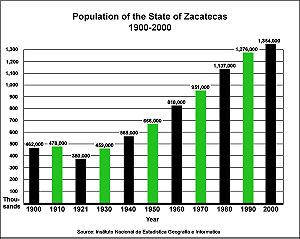
The state of Zacatecas has a population of 1,441,734 inhabitants. It has more than tripled in a century, in 1900 its population was 462,190. About 5% of the population is mestizo and 95% is white. In the year 2008, Zacatecas had the smallest indigenous population percentage-wise in Mexico: 0.3%. Only the state of Aguascalientes has a smaller number of indigenous people, numbering 3,472; Zacatecas has 4,039 indigenous people.[1] In the last ten years, Zacatecas' population has grown a mere 6%, well below the country's average growth of 20%.[2] It is estimated that half of the people from Zacatecas do not reside in the state. The biggest concentration of Zacatecanos outside Mexico is in the United States, with a population of approximately 800,000-1,000,000, almost as many people as in the state itself. Most are concentrated in cities such as, Chicago, Denver, Dallas, Houston, Los Angeles and Phoenix. It fact, there are more Zacatecanos living in the Los Angeles area than in the city of Zacatecas itself.
Cities
The largest city in terms of population in the state of Zacatecas is Fresnillo, with a population of 183,236 (2005). It is followed by the state capital of Zacatecas with a population of 118,562 (2005). Next is Sombrerete with 61,652.
Many of the Zacatecanos who have migrated to the USA feel so pasionate about where they come from small unions of zacatecas have formed. Madison, Georgai for example has a club formed by Trancosenos from Zactatecas. They find ways to help the community in Zacatecas and the ones who live in the USA as well. The founder of this group is Rosalio Lopez.
Tourist destinations
The state has touristic cities like: Zacatecas, and Sombrerete. Near Sombrerete is a small town called La Noria, it is small but on July 27 they have a big festival celebrating the saint "San Pantaleon". There are other places like Jerez, and places like Sierra de Organos, Sierra de Cardos, and Altavista.
- Zacatecas: The colonial center of this city is a UNESCO World Heritage site and features elaborately decorated buildings, cobblestoned streets, and wrought-iron lanterns.
- Sombrerete: Colonial city established in 1555 as a village, actually is a small city, is the fifth most important in the state, and considered the second most beautiful city in the state. The city features old and beautiful churches built in the New Spain Era, with decorated, old buildings. The municipality has touristic forests, and Sierra de Organos, world famous for filming of western movies.
- Jerez de Garcia Salinas: A city near the capital city of Zacatecas (Zacatecas City), has colonial buildings and the Santuario and Parroquial Churches, made known internationally by Lopez Velarde, a writer born in that city. It also has beautiful colonial buildings some of which are now lighted at night. Jerez was designated as a "Pueblo Mágico" in 2007 because of its customs, traditions, cuisine and its people. More than 20 years in the past (1988) it had already been designated as a National Monument.
consepcion del oro zacatecas
Government

The current governor of Zacatecas is Amalia García Medina (PRD) who will end her 6 year term in 2010 after winning the election of 2004. She became the first female governor on September 12, 2004. The state is represented by three representatives in the Mexican senate: Mejía Haro Antonio (PRD), Tomás Torres Mercado (PRD) and José Isabel Trejo Reyes (PAN). Zacatecas also has 9 representatives in the Mexican Chamber of Deputies: 9 of the Party of the Democratic Revolution, 3 of the National Action Party and 1 of the Ecologist Green Party.
Municipalities
Zacatecas is subdivided into 58 municipalities (municipios). Mazapil by far is the largest municipality in the state, occupying about 16% of the area of the state. The Municipality of Momax is the smallest one in area with only 164.538 km².
Major communities
- Fresnillo
- Guadalupe
- Jalpa
- Jerez de García Salinas
- Juan Aldama
- Loreto
- Ojocaliente
- Río Grande
- Sombrerete
- Victor Rosales
- Zacatecas
- Valparaiso
- El Tejujan
- Chalchihuites
- Sain Alto
See also List of towns in Zacatecas
Notable people
- Postnecrum, black metal band
- Antonio Aguilar, singer, actor
- Cynthia Klitbo, actress
- Pepe Aguilar, singer
- Rebecca de Alba, model
- Susana González, actress
- Don Juan de Oñate, Mexican-born conquistador of Spanish parents
- Mateo Correa Magallanes, 1866-1927, saint and martyr
- Manuel María Ponce, composer
- Los Temerarios, music group
- Ramón López Velarde, Mexican poet of the 19th Century, poet of "La Suave Patria"
- Florinda Meza, actress
- Sergio Santana, soccer player
- Benjamin Galindo, former soccer player
- Maria del Rosario Castro
- Marco Antonio Flores
- Pedro Aguayo "Perro Aguayo", Mexican wrestler
- Efraín Flores Mercado soccer player
Notes
- ↑ Schmal, John P. (2004). "The Hispanic Experience - Indigenous Identity in Mexico". Retrieved on 2007-12-15.
- ↑ Katel, Peter (2001). "The New Frontier". CNN. Retrieved on 2007-12-15.
postnecrum- black metal de zacatecas
External links
- Portal with News and Information about Zacatecas
- Zacatecas state government
- Zacatecas travel guide from Wikitravel
- (Spanish) Towns, cities, and postal codes in Zacatecas
- (Spanish)Noticias, Hisotria, Foros, Fotos, todo de Zacatecas
|
||||||||||