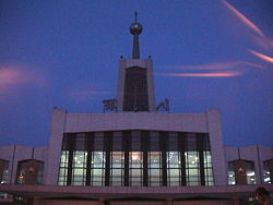
Yinchuan
| Yinchuan 银川 |
|
| — Prefecture-level city — | |
 |
|
 |
|
 |
|
 Yinchuan
|
|
| Coordinates: | |
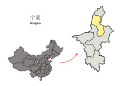
| Country | China |
|---|---|
| Province | Ningxia |
| County-level divisions | |
| Township divisions | |
| Government | |
| - CPC Yinchuan | |
| - Mayor | Wang Rugui[1] |
| Area | |
| - Total | 4,467 km² (1,724.7 sq mi) |
| Elevation | 1,100 m (3,608 ft) |
| Population | |
| - Total | 1,200,000 |
| - Density | 268.6/km² (695.8/sq mi) |
| Time zone | China Standard Time (UTC+8) |
| Postal code | 750000 |
| Area code(s) | 951 |
| License plate prefixes | 宁A |
| Website: www.yinchuan.gov.cn (Chinese) | |
Yinchuan (simplified Chinese: 银川; traditional Chinese: 銀川; pinyin: Yínchuān Shì) is the capital of Ningxia Hui Autonomous Region, People's Republic of China, and former capital of the Western Xia Empire of the Tanguts. It has an area of 4,467 km² and an estimated population of 1.2 million.
Contents |
Geography
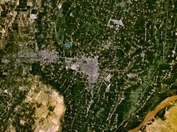
Yinchuan lies in the middle of the Yinchuan or Ningxia Plain. It is sheltered from the deserts of Mongolia by the high ranges of the Helan Mountain to its west. The Yellow River runs through Yinchuan from southwest to northeast. The average elevation of Yinchuan is 1,100 meters (about 3,608 feet).
Climate
Yinchuan has a temperate continental climate with an annual average temperature of 8.5C, and has 158 frost-free days. Annual rainfall averages 200 millimeters.
History
Yinchuan originally was a xian (county) under the name of Fuping in the 1st century BC; its name was changed to Huaiyuan in the 6th century AD. After the fall of the Tang dynasty in 907, it was occupied by the Tangut Peoples' Xi-Xia dynasty, of which it was the capital. After the destruction of the Xi-Xia dynasty by the Mongols in 1227, it came under the rule of the Mongol dynasty. Under the Ming (1368–1644) and Qing (1644–1911) dynasties, it was the fu (prefecture) of Ningxia. In 1928, when the province of Ningxia was formed from parts of Gansu and Inner Mongolia, it became the capital city. In 1954, when Ningxia province was abolished, the city was put in Gansu province; but, with the establishment of the Ningxia Hui autonomous region in 1958, Yinchuan once again became the capital.
Traditionally, Yinchuan was an administrative and commercial center. In the 1950s it had many commercial enterprises, and there were some handicrafts but no modern industry. The city has since grown considerably. Extensive coal deposits discovered on the eastern bank of the Yellow River, near Shizuishan, 100 km to the north, have made Shizuishan a coal-mining center.
Yinchuan, however, remains largely nonindustrial. The immediate plains area, intensively irrigated by a system developed as long ago as the Han (206 BC–AD 220) and Tang (618–907) dynasties, is extremely productive. Yinchuan is the chief agricultural market and distribution center for this area and also deals in animal products from the herds tended by nomads in the surrounding grasslands. It is a market for grain and has flour mills, as well as rice-hulling and oil-extraction plants. The wool produced in the surrounding plains supplies a woolen-textile mill. Yinchuan is a center for the Muslim (Hui) minority peoples, who constitute a third of the population.
On July 23, 1993 an airliner that was attempting its second takeoff veered off the runway, crashed into a lake, and broke apart; at least 59 of the 113 persons aboard the craft were killed.[2]
Economy
The city's gross domestic product per capita was ¥11975 (US$1450) in 2003, ranking 197th of 659 Chinese cities. Its main industries are the production of Chinese wolfberry, wheat, apple, and rice.
Transportation
Yinchuan is located near the western bank of the upper course of the Yellow River, near the western end of the Great Wall of China in the south-central section of the Helan Shan and Ordos Desert. It is served by a river port at Hengcheng, about 15 km to the east. Until the 1950s the river, which is navigable downstream as far as Baotou in the Inner Mongolian autonomous region and upstream to Zhongwei and Zhongning, was the chief communication link. Highways also link the city to Baotou along the river, to Lanzhou in Gansu province to the southwest, to Wuwei in Gansu to the west, and to Xi'an in Shaanxi province to the southeast. Since 1958 the city has been on the railway from Lanzhou to Baotou and is thus linked to other parts of China by rail.
Tourism
The city's attractions include the Sand-lake and XiXia mausoleum. There are two pagodas in Yinchuan that are part of the 'Eight Famous Scenery of Ningxia': one is the Haibao Pagoda in the northern suburb and the other is the Chengtiansi Pagoda in the west.
Since 2000, Yinchuan has hosted the annual Yinchuan International Car and Motorcycle Tourism Festival, which usually occurs in August. It is the largest event of its kind in China; approximately 3000 motorcycles attend annually.
It is also possible to see part of the Great Wall which is located about 60 km south-west of the city. Take the bus from in front of the A La Shun hotel that is heading to zuo qi, and get off at the 'san guan kou' stop which is right beside the Great Wall (the trip take 45 min to an hour). The whole trip costs less than $4 and is well worth the visit.
Colleges and universities
- Ningxia Polytechnical University
- Ningxia University
- Second Northwest Nationalities University
- Ningxia Medical Institute

2006 Internet phenomenon
Yinchuan was subject to an Internet phenomenon after a user of Google Earth posted images of what he/she believed was a secret People's Liberation Army military facility.[3] The facility, estimated at around 630,000 m² in size, is 35 km from Yinchuan and in the town of Huangyangtan. The purpose of the facility was speculated on the Internet following the original posting, although no official explanation for the site has been given. A subsequent posting of a photograph on the Chinese wforum.com claimed that it constituted a terrain model of the disputed Aksai Chin region of China;[4][5][6] the image includes a watermark of Xinhua News Agency, the official press agency of the government of the People's Republic of China.
Authorities in the Ningxia Hui Autonomous Region have been quoted as saying that the site is used as a tank training facility.[7]
References
- ↑ Foreign Investment Administration, MOFCOM (2008-04-18). "Large Bearing Project of Schaeffler Group Started Construction in Yinchuan ETDZ". Press release. Retrieved on 2008-07-17. “Wang Rugui, Mayor of Yinchuan on behalf of the CPC Committee of Yinchuan and the municipal government expressed the warm congratulation to [sic] the start of the project.”
- ↑ July 23 Events in History
- ↑ Google Earth Community (2006). China - Huangyangtan - Scale model of landscape?. Retrieved August 14, 2006.
- ↑ Hutcheon, Stephen (14 August 2006). "The riddle of China's Area 51", The Age.
- ↑ Aroor, Shiv (5 August 2006). "From sky, see how China builds model of Indian border 2400 km away", Indian Express.
- ↑ Haines, Lester (19 July 2006). "Chinese black helicopters circle Google Earth", The Register.
- ↑ Hutcheon, Stephen (23 July 2006). "Chinese X-file not so mysterious after all", The Age.

External links
|
|||||||||||||||

|
||||||||||||||||||||||||