Yellowknife
| Yellowknife, Northwest Territories Somba K'e |
|||
 |
|||
|
|||
| Motto: Multum In Parvo (Much In Little) | |||
 |
|||
| Coordinates: | |||
| Country | |||
|---|---|---|---|
| Territory | |||
| Region | North Slave Region | ||
| Established | 1936/1937 | ||
| Government | |||
| - City Mayor | Gordon Van Tighem | ||
| - Governing Body | Yellowknife City Council | ||
| - MPs |
List of MPs
|
||
| - MLAs |
List of MLAs
|
||
| Area | |||
| - Total | 136 km² (84.5 sq mi) | ||
| Elevation | 206 m (675 ft) | ||
| Population (2006)[1] | |||
| - Total | 18,700 | ||
| - Density | 157.2/km² (407.1/sq mi) | ||
| - 2005 city est. | 19,429 | ||
| Time zone | Mountain (MST) (UTC-7) | ||
| - Summer (DST) | MDT (UTC-6) | ||
| Canadian Postal code | X1A | ||
| Area code(s) | 867 | ||
| Telephone Exchanges | 444 445 446 669 765 766 767 873 920 999 | ||
| GNBC Code | LBAMG | ||
| NTS Map | 085J08 | ||
| Website: City of Yellowknife | |||
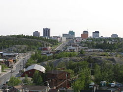
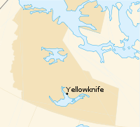
Yellowknife(IPA: /ˈjɛloʊnaɪf/) (2006 population 18,700 [1]) is the capital of Canada's Northwest Territories (NWT). It is located on the north shore of Great Slave Lake, approximately 400 km (250 mi) south of the Arctic Circle, on the west side of Yellowknife Bay near the outlet of the Yellowknife River. Yellowknife and its surrounding water bodies were named after the local Yellowknives Dene First Nation, who made tools from regional copper deposits. The current population is ethnically mixed. Of the eleven official languages of the Northwest Territories, five are spoken in significant numbers in Yellowknife: Dene Suline, Dogrib, South and North Slavey, English, and French. In the Dogrib language, the city is known as Somba K'e ("where the money is").[2]
Yellowknife was first settled in 1935, after gold had been found in the area; Yellowknife soon became the centre of economic activity in the NWT, and became the capital of the Northwest Territories in 1967. As gold production began to wane, Yellowknife shifted from being a mining town to being a centre of government services in the 1980s. However, with the recent discovery of diamonds north of Yellowknife, this shift has begun to reverse.
Contents |
History
Traditionally, First Nations people had occupied this region; by the 1930s they had a settlement on a point of land on the east side of Yellowknife Bay, Dettah.[3] The current municipal area of Yellowknife was occupied by prospectors who ventured into the region in the mid-1930s.[4]
A Klondike-bound prospector, B.A. Blakeney, made the first discovery of gold in the Yellowknife Bay area in the late 19th century. The discovery was viewed as unimportant in those days because of the Klondike Gold Rush and because Great Slave Lake was too far away to attract attention.[5]
In the late 1920s, aircraft were first used to explore Canada's Arctic regions. Samples of uranium and silver were uncovered at Great Bear Lake in the early 1930s, and prospectors began fanning out to find additional metals.[6] In 1933 two prospectors, Herb Dixon and Johnny Baker, canoed down the Yellowknife River from Great Bear Lake to survey for possible mineral deposits. They found gold samples at Quyta Lake, about 30 km (19 mi) up the Yellowknife River, and some additional samples at Homer Lake.[7]
The following year, Johnny Baker returned as part of a larger crew to develop the previous gold finds and search for more. Gold was found on the east side of Yellowknife Bay in 1934 and the short-lived Burwash Mine was developed. When government geologists uncovered gold in more favourable geology on the west side of Yellowknife Bay in the fall of 1935, a small staking rush occurred.[8] Con Mine was the most impressive gold deposit and its development created the excitement that led to the first settlement of Yellowknife in 1936-1937; the mine entered production on September 5, 1938.

The population of Yellowknife quickly grew to 1,000 by 1940, and by 1942, five gold mines were in production in the Yellowknife region. However, by 1944, gold production had ground to a halt as men were needed for the war effort. An exploration program at the Giant Mine property on the north end of town had suggested a sizable gold deposit in 1944. This new find resulted in a massive post-war staking rush to Yellowknife.[9] It also resulted in new discoveries at the Con Mine, greatly extending the life of the mine. The Yellowknife townsite expanded from the Old Town waterfront, and the new townsite was established during 1945–1946. The Discovery Mine, with its own townsite, operated 81 km (50 mi) to the north-northeast of Yellowknife from 1950 to 1969.[10]
Between 1939 and 1953, Yellowknife was controlled by the Northern Affairs department (now Indian and Northern Affairs Canada) of the Government of Canada. A small council, partially elected and partially appointed, made decisions. By 1953, Yellowknife had grown so much that it was made a municipality, with its own council and town hall. The first mayor of Yellowknife was John "Jock" McNiven. In September 1967, Yellowknife officially became the capital of the Northwest Territories. This important new status sparked what has been coined as the third boom in Yellowknife. New sub-divisions were established to house an influx of government workers.[11]
In 1978 the Soviet nuclear-powered satellite Cosmos 954 crashed to earth near Yellowknife. There were no known casualties although a small quantity of radioactive nuclear fuel was released into the environment and Operation Morning Light—an attempt to retrieve it—was only partially successful.[12] A new mining rush and fourth building boom for Yellowknife began with the discovery of diamonds 300 km (190 mi) north of the city in 1991.[13]
The last of the gold mines in Yellowknife closed in 2004. Today Yellowknife is primarily a government town and a service centre for the diamond mines. On April 1, 1999, its purview as capital of the NWT was reduced when the territory of Nunavut was split from the NWT. As a result, jurisdiction for that region of Canada was transferred to the new capital city of Iqaluit. Consequently, Yellowknife lost its standing as the Canadian capital city with the smallest population.[14]
Law and government

Yellowknife has a municipal government system and is governed by the Yellowknife City Council which consists of an elected Mayor and eight Councillors.[15] The Government of the Northwest Territories delegates powers to the municipality through legislative acts and regulations. Council meetings are held in the Council Chambers at City Hall on the second and fourth Monday of each month, and are open to the public. Municipal elections are held every three years.[16] The current mayor of Yellowknife is Gordon Van Tighem.
Yellowknife is represented in the territorial government by seven of the 19 Members of the Legislative Assembly of the Northwest Territories (MLAs). These MLAs are elected every four years and sit in the Northwest Territories Legislative Building, located in Yellowknife. The MLAs elect the Speaker of the House as well as six Cabinet Ministers and the Premier, which comprises the Cabinet.[17] In addition, a Commissioner is appointed by the Federal Government to fulfill a similar role to that of the Lieutenant Governor.[18] The Northwest Territories is one of only two federal, provincial or territorial jurisdictions in Canada that operates under a consensus system of government.[17]
The Northwest Territories is in the federal electoral riding of the Western Arctic and has one Member of Parliament and one Senator, currently Dennis Bevington and Nick Sibbeston, respectively.[19][20] Yellowknife is home to seven of the 19 electoral districts in the Northwest Territories, the Frame Lake, Great Slave, Kam Lake, Range Lake, Weledeh, Yellowknife Centre and Yellowknife South ridings.[21]
Economy

As the largest city in the Northwest Territories, Yellowknife is the hub for mining, industry, transportation, communications, education, health, tourism, commerce, and government activity in the territory.[22] Historically, Yellowknife's economic growth came from gold mining, and later government; however, because of falling gold prices and increased operating costs, the final gold mine closed in 2004, marking a turning point for Yellowknife's economy.[23]
After a downturn in the 1990s during the closure of the gold mines and the downsizing of the government workforce in 1999, Yellowknife's economy has recovered, largely because of the diamond boom;[23] The Ekati Diamond Mine, owned and operated by BHP Billiton, opened in 1998[24] a second mine, Diavik Diamond Mine, began production in 2003.[25] Production from the two operating mines in 2004 was 12,618,000 carats (2,524 kg/5,564 lb) valued at over C$2.1 billion. This ranked Canada third in world diamond production by value, and sixth by weight. A third mine, De Beers' Snap Lake Diamond Mine, received final approval and funding in 2005 and went into production in 2007.[26] De Beers also applied in 2005 for a permit to open the Gahcho Kue Diamond Mine Project on the property formerly known as Kennady Lake. Upon receipt of approval, construction is expected to start in 2010 and the mine will reach full production by 2012.[27] As well, growth and expansion in natural gas development and exploration sectors has contributed to this growth. Economic growth in the Northwest Territories was 10.6% in 2003.[28]
The major employers in Yellowknife include: the Territorial Government, the Federal Government, Diavik Diamond Mines Incorporated (a subsidiary of Rio Tinto Group)/Harry Winston Diamond Corporation, BHP Billiton, First Air, NorthwesTel, RTL Robinson Trucking, and the City of Yellowknife. Government employment accounts for 7,644 jobs, a large percentage of those in Yellowknife.[29]
During winter, the Tibbitt to Contwoyto Winter Road is opened for semi-trailer truck traffic to take supplies from Yellowknife north to various mines located in the Northwest Territories and Nunavut. This ice road is usually open from the end of January through late March or early April, and Yellowknife becomes the dispatch point for the large number of truck drivers that come north to drive on the ice roads. During the 2007 ice road season, several drivers were featured on the History Channel TV series Ice Road Truckers.

Tourism is the largest renewable industry in the NWT and Yellowknife is the main entry point for visitors. Many of these tourists are Japanese, and come to experience the Northern climate and traditional lifestyle, as well as to see the Northern Lights. In 2004-05, visitors to the territory spent C$100.5 million.[16]
The City of Yellowknife raises 50% of its operating revenue through property taxation. Yellowknife School Districts also raise a portion of their operating revenue through property taxation. Property taxes in Yellowknife are calculated through property assessment and the municipal and education mill rates. Mill rates in 2005 were 13.84 (residential) and 19.87 (commercial).[16]
Regional mines
Yellowknife was originally established as a supply center for numerous gold mines operating in the region in the late 1930s and early 1940s. The following is a list of the major mines, all of which are now closed. There were also tungsten, tantalum, and uranium mines in the vicinity. Most mines in the Yellowknife area are within the Kam Group, a part of the Yellowknife Volcanic Belt.[30]


| Mine | Years of Operation | Minerals Mined |
|---|---|---|
| Con Mine (includes Rycon) | 1938-2003 | gold |
| Giant Mine | 1948-2004 | gold |
| Ptarmigan and Tom Mine | 1941-1942, 1985-1997 | gold |
| Negus Mine | 1939-1952 | gold |
| Burwash Mine | 1935 | gold |
| Thompson-Lundmark Mine | 1941-1943, 1947-1949 | gold |
| Discovery Mine | 1950-1969 | gold |
| Camlaren Mine | 1962-1963, 1980-1981 | gold |
| Beaulieu Mine | 1947-1948 | gold |
| Outpost Island Mine | 1941-1942, 1951-1952 | gold, copper, tungsten |
| Ruth Mine | 1942, 1959 | gold |
| Rayrock Mine | 1957-1959 | uranium |
| References: [31][32][33] | ||
Climate and physical geography
Yellowknife has a semi-arid subarctic climate[34] and averages less than 300 mm (12 in) of precipitation annually, as the city lies in the rain shadow of mountain ranges to the west.[35] Thanks to its location on Great Slave Lake, Yellowknife has a frost-free growing season that averages slightly over 100 days.[36] Most of the limited precipitation falls between June and October, with April being the driest month of the year and August being the wettest. Snow that falls in winter accumulates on the ground until the spring thaw.
| Month | Jan | Feb | Mar | Apr | May | Jun | Jul | Aug | Sep | Oct | Nov | Dec | Year |
|---|---|---|---|---|---|---|---|---|---|---|---|---|---|
| Record high °C (°F) | 3.4 (38) |
6.2 (43) |
9.3 (49) |
20.3 (69) |
26.1 (79) |
30.3 (87) |
32.5 (91) |
30.9 (88) |
26.1 (79) |
31.0 (88) |
7.8 (46) |
2.8 (37) |
32.5 (91) |
| Average high °C (°F) | -22.7 (-9) |
-18.6 (-1) |
-11.2 (12) |
0.4 (33) |
10.6 (51) |
18.2 (65) |
21.1 (70) |
18.2 (65) |
10.3 (51) |
1.0 (34) |
-9.9 (14) |
-19.7 (-3) |
-0.2 (32) |
| Average low °C (°F) | -30.9 (-24) |
-28.1 (-19) |
-23.3 (-10) |
-11.0 (12) |
0.5 (33) |
8.7 (48) |
12.4 (54) |
10.3 (51) |
3.8 (39) |
-4.4 (24) |
-17.7 (0) |
-27.7 (-18) |
-9.0 (16) |
| Record low °C (°F) | -51.2 (-60) |
-51.2 (-60) |
-43.3 (-46) |
-40.6 (-41) |
-22.8 (-9) |
-4.4 (24) |
0.6 (33) |
-0.6 (31) |
-9.7 (15) |
-28.9 (-20) |
-44.4 (-48) |
-48.3 (-55) |
-51.2 (-60) |
| Precipitation mm (inches) | 14.1 (0.56) |
12.9 (0.51) |
13.4 (0.53) |
10.8 (0.43) |
19.1 (0.75) |
26.9 (1.06) |
35.0 (1.38) |
40.9 (1.61) |
32.9 (1.3) |
35.0 (1.38) |
23.5 (0.93) |
16.3 (0.64) |
280.7 (11.05) |
| Source: Environment Canada[35] Jan 2007 | |||||||||||||
Yellowknife is located on the Canadian Shield, which was scoured down to rock during the last ice age.[36] The surrounding landscape is very rocky and slightly rolling, with many small lakes in addition to the larger Great Slave Lake.[37] Trees such as pine and birch are abundant in the area, as are smaller bushes, but there are also many areas of relatively bare rock with lichen.[38] Yellowknife's high latitude cause a large variation between night and day ranging from 5 hours of daylight in December to 20 hours in June and twilight lasts all night from late May to early July. Yellowknife also gets the sunniest summers in Canada.
Infrastructure

Emergency services
Policing in Yellowknife is provided by the Royal Canadian Mounted Police; Yellowknife is the headquarters for the G Division, and houses more than 30 officers. Municipal enforcement services are provided by bylaw enforcement officers, who are employed by the city. The Yellowknife Fire Department handles the city's fire, ambulance, rescue, and hazardous materials responses.[39] A point of debate in recent years has been the implementation of 911 services in Yellowknife (currently one must dial one of two local numbers); the cost of installation is high, and there have been a number of incidents where emergency services have been either misdirected, or improperly dispatched.[40]
Utilities and services
Electricity is provided to Yellowknife by Northland Utilities, serving 6,350 residential and 800 commercial customers. Yellowknife operates almost entirely on hydroelectricity from the Snare-Bluefish systems[41], provided by the Northwest Territories Power Corporation (NTPC). NTPC's local production capacity is 67.9 megawatts, 30.89MW from 10 generators at the Jackfish Diesel Plant, 28.8MW from Snare Lake, and 7.5MW from Miramar Bluefish.[42] The City of Yellowknife provides pressurized potable water throughout the majority of the city, and has a network of gravity-fed sewage lines; trucked water and sewage is provided in areas not services by piped infrastructure. Sewage, with the aid of lift stations, is pumped to a series of lakes, referred to as Fiddler's Lake Lagoon, where it is held and allowed to naturally decompose. Water is obtained from the Yellowknife River and is disinfected with chlorine and liquid fluoride is added, but is not otherwise filtered or treated.[43] Residential garbage removal is through a user pay system, in which residents are allowed three 77 l (17 imp gal/20 US gal) garbage bags per week; any additional bags must have a purchased tag.[39] The City of Yellowknife Solid Waste Management Facility is located on the Ingraham Trail (Highway 4) 2 km (1.2 mi) north of the city;[44] salvaging is encouraged, and the dump is infamous for the number of still useful items often found in it.[45]
Transportation

Yellowknife, while isolated geographically, has a modern transportation system. The Yellowknife Airport (IATA: YZF) is the busiest airport in northern Canada, having 70,699 aircraft movements in 2007, and handling over 400,000 passenger and 30,000 tonnes of cargo yearly.[46] It has two asphalt runways, one 7,500 ft (2,300 m) strip and 5,000 ft (1,500 m) strip[47]; while classified as an airport of entry by NAV CANADA and is staffed by the Canada Border Services Agency, they are certified for general aviation aircraft only, with no more than 15 passengers.[48]. However the airport can accommodate 747s and other wide-body aircraft for emergency landings.[49][50] Air traffic control services, ILS (Category 1), and radar services are provided by NAV CANADA.
Road construction in Yellowknife is often a challenge due to the presence of permafrost, and roads often need to be leveled and resurfaced every 10 to 20 years. All roads in Yellowknife are paved, and road width varies from 9 to 13.5 m (30 to 44 ft). During the winter, snow removal is done on a regular schedule by the City of Yellowknife.[39] Speed limits are 45 km/h (28 mph) on most roads, 30 km/h (19 mph) in school zones, and 70 km/h (43 mph) on highways. Public transit is provided by Cardinal Coach Lines on contract from the City of Yellowknife. Three bus routes are operated, with express buses during peak hours.[51] The highway system in the NWT is maintained by the Government of the Northwest Territories. Highway 4 (Ingraham Trail) and Highway 3 (Yellowknife Highway) both run through Yellowknife and are all-weather roads.[39] One well-known, almost infamous, road in Yellowknife is Ragged Ass Road, which Tom Cochrane named an album after.
Layout
Yellowknife, like most other urban centres, has distinct commercial, industrial, and residential areas. Frame Lake, Niven Lake, Range Lake, and Old Town are the residential sectors, with some of the population living in high-rises in the downtown core. Niven Lake is the only area under active development and expansion.[52] Downtown Yellowknife is home to most of the city's commercial activity, though some retail does exist in Range Lake. Industrial activity is limited to the Kam Lake and airport subdivisions.[53]
Demographics
| Historical populations | |||
|---|---|---|---|
| Year | Pop. | %± | |
| Est. 1996 | 18,258 |
|
|
| Est. 1997 | 18,306 | 0.3% | |
| Est. 1998 | 17,671 | -3.5% | |
| Est. 1999 | 17,483 | -1.1% | |
| Est. 2000 | 17,415 | -0.4% | |
| Est. 2001 | 17,758 | 2.0% | |
| Est. 2002 | 18,273 | 2.9% | |
| Est. 2003 | 18,958 | 3.7% | |
| Est. 2004 | 19,312 | 1.9% | |
| Est. 2005 | 19,429 | 0.6% | |
| Est. 2006 | 18,700 | -3.8% | |
As of the 2005 city survey, there were 19,429 people and 5,795 households in the city.[54] The population density was 142.86 people/km² (369.85 people/sq. mi). The 2006 Census found that 22.2% of residents identified as aboriginal.[55]
In Yellowknife, the population is slightly disproportionate in terms of age distribution compared to the national average; the average age is 31.2, compared to a Canada-wide average of 39.5.[56] As of the 2005 survey, 15.2% of residents were 9 or under, 7.8% were from 10 to 14 years old, 16.1% were from 15 to 24, 36.3% were from 25 to 44, 19.5% were from 45 to 59, and 5.1% were 60 or older. From 1996 to 2005, the average annual growth rate was 0.7% for the total population; broken down by age, it was -0.4% for < 15 years, and 7.1% for 60 years and older.[54]
In 2003, two-person households in Yellowknife were the most common household size at 28.8%. Overall, almost half of all households had only one or two occupants. The average income in the city was C$52,061, and the average income for a family was C$111,665. Minimum wage is C$8.25 in Yellowknife, the second highest in Canada. [57] Average household expenditures were C$90,139.[16] In 2004, unemployment rates were at 5.0%, an all-time low; the employment rate for males was 83.8%, for females it was 75.5%.[54]
The crime rate in Yellowknife is 42.9 (per 1,000 persons) for violent crimes, and 50.3 (per 1,000 persons) for property crimes.[58] There were 316 births and 60 deaths in 2005.[59][60]
Almost 82% of residents spoke English as their mother tongue and almost 4% spoke French. More than 4% spoke an aboriginal language as their first language, including 1.3% who spoke Inuktitut, another 1.3% who spoke Dogrib, and 0.6% who spoke North Slavey, 0.5% who spoke Dene/Chipewyan, and 0.4% who spoke South Slavey. Other languages spoken in Yellowknife include Tagalog at 2.3%, Vietnamese at 1.6%, Chinese at 1.1%, German at 0.7% and Spanish at 0.4%.[61]
Yellowknife is home to just over 500 recent immigrants (arriving between 2001 and 2006) who now comprise just under 3% of the population; 36% of these immigrants came from the Philippines, while 18% came from Ghana, 9% from Vietnam, 7% from the United States, and 5% came from China.[62]
Almost 73% of residents identified as Christian while 24% said they had no religious affiliation in 2001. For specific denominations Statistics Canada found that 36% of residents identified as Roman Catholic, 11% as Anglican, 10% for the United Church, about 2% each as Baptist, Lutheran, and Pentecostal, and more than 1% for The Salvation Army.[63]
Culture
Events

Folk on the Rocks is a local music festival that has been an annual occurrence since 1980, and features a wide variety of musical acts, and is not limited to only Folk. In the past, it has drawn acts such as Buffy Sainte-Marie, the Trailer Park Boys, The Weakerthans, African Guitar Summit, Mad Bomber Society, Gob, and Hawksley Workman.[64] The Midnight Sun Golf Tournament, with games played through the well-lit summer nights in Yellowknife, is also a significant cultural event in Yellowknife.[65] In previous years, there was an annual summer festival known as Raven Mad Daze, a street festival celebrated as part of the summer solstice. The festival was not celebrated in 2007 because an organizer was not found for the event.[66] During the winter, there is the Snowking Winter Festival, featuring a snow castle on Great Slave Lake,[67] and Caribou Carnival, which is held every March on Frame Lake and has ice sculpting competitions, dogsled races, and a fireworks display.[68] In 2008, Yellowknife hosted the Arctic Winter Games.[69]
Places

Some notable places to visit in Yellowknife include:
- The Wildcat Cafe, which first opened in 1937. The popular restaurant still operates in its original building during the summer, which was moved to its current location after being saved from demolition in the late 1970s.[70]
- The Gold Range Bar, one of the oldest and most colorful drinking establishments in the Northwest Territories and featured in Mordecai Richler's novel Solomon Gursky Was Here)[71]
- Downtown contains the Capital Area Park, a short but pleasant stroll by City Hall,[72] the Prince of Wales Northern Heritage Centre,[73] the Legislature,[74] and the Northern Frontier Visitors Centre.[75]
- The Prince of Wales Northern Heritage Centre (Museum) contains exhibits of the history and culture of Inuit, Inuvialuit, Dene, Métis, and non-aboriginal peoples of the NWT. It's found just north of downtown on an attractive lakeside location.
- Near the Prince of Wales Northern Heritage Centre, the Northwest Territories Legislative Building houses the territory's legislative assembly.
- The Northern Arts and Cultural Centre, which is located in Sir John Franklin High School and is the city's largest indoor stage for theatre and musical presentations[76].
Other notable attractions include the Ingraham Trail, local fishing lodges, bush plane tours, the unique architecture of Old Town with the Bush Pilots monument, and any of the numerous lakes surrounding Yellowknife, many of which include beaches.
Media
The Yellowknifer, published by Northern News Services, is the major newspaper serving Yellowknife, published twice weekly on Wednesday and Friday. Northern News Services also publishes News/North NWT every Monday, which serves the entire NWT. As well, there is L'Aquilon, a French-language newspaper published weekly.
The major radio stations based in Yellowknife are: CFYK 1340, which broadcasts CBC Radio One network programs and locally produced programs; CFYK-FM 95.3, which broadcasts the programming of the CBC Radio 2 network; CJCD 100.1, which plays largely adult contemporary music; CKLB 101.9, a community radio station; and CIVR 103.5, a French-language community radio station.
The major locally broadcast television stations include: CFYK channel 8, which broadcasts the northern feed of CBC Television; CHTY channel 11, is the Aboriginal Peoples Television Network; CH4127 channel 13, is the French feed of CBC, Télévision de Radio-Canada.
Two magazines are based in Yellowknife: Above & Beyond - Canada's Arctic Journal and Up Here Magazine, both offering northern-related news and lifestyle articles.
Notable people
- Bill Braden, politician and former news reporter.
- Joe Handley, former teacher and tenth premier of the Northwest Territories.
- Margot Kidder, film and television actress best known for playing Lois Lane in the Superman movies of the 1970s and 1980s.
- Tobias Mehler, television and theatre actor best known for his roles on Battlestar Galactica and Stargate SG-1.
- Dustin Milligan, film and television actor; the lead actor in the upcoming Beverly Hills 90210 spinoff.
- John Sissons, politician and the first judge of the Supreme Court of the Northwest Territories.
- Max Ward, pioneering bush pilot and founder of Wardair airlines (later sold to Canadian Airlines).
- Les Stroud, film maker and survival expert best known as the host of the television program Survivorman.
- Alex Deborgoski, local truck driver and personality on Ice Road Truckers
See also
- History of Northwest Territories capital cities
- Yellowknife Water Aerodrome
- Yellowknife (Regional Hospital) Heliport
- CFNA HQ Yellowknife
References
- ↑ 1.0 1.1 "2006 Census". Government of Canada.
- ↑ "Yellowknife Visitors Guide" (PDF). Yellowknifer. Retrieved on 2007-07-26.
- ↑ "Agreements, Treaties, and Negotiated Settlements Project". Indigenous Studies Program, The University of Melbourne. Retrieved on 2008-02-22.
- ↑ "Old Town" (PDF). City of Yellowknife. Retrieved on 2008-02-22.
- ↑ Price, Ray. Yellowknife, Peter Martin Associates, Toronto, 1967. Page 22.
- ↑ Watt, Frederick B. Great Bear: A Journey Remembered, Outcrop, Yellowknife, 1980. ISBN 0-919315-00-3.
- ↑ "Northwest Territories Timeline - "Yellowknife Johnny" Baker". Prince of Whales Northern Heritage Centre. Retrieved on 2008-01-23.
- ↑ "Northwest Territories Timeline - Dr. Alfred Joliffe, Geological Survey of Canada". Prince of Whales Northern Heritage Centre. Retrieved on 2008-01-23.
- ↑ Decoursey, Duke. The Yellowknife Years, Parkview Publishing, Squamish, British Columbia. Page 112.
- ↑ "Northwest Territories Timeline - Discovery Mine". Prince of Whales Northern Heritage Centre. Retrieved on 2008-01-23.
- ↑ "Yellowknife (NWT)-Government". Historica Foundation of Canada. Retrieved on 2008-01-23.
- ↑ "Northwest Territories Timeline - Cosmos 954 and Operation Morning Light". Prince of Whales Northern Heritage Centre. Retrieved on 2008-01-23.
- ↑ "Northwest Territories Timeline - Discovery of Diamonds in the NWT". Prince of Whales Northern Heritage Centre. Retrieved on 2008-01-23.
- ↑ "Northwest Territories Timeline - The Division of the NWT and Nunavut". Prince of Whales Northern Heritage Centre. Retrieved on 2008-01-23.
- ↑ "City Council". City of Yellowknife. Retrieved on 2008-02-23.
- ↑ 16.0 16.1 16.2 16.3 "Yellowknife Community Profile 2006" (PDF). City of Yellowknife (2006-08-17). Retrieved on 2007-05-09.
- ↑ 17.0 17.1 "Consensus Government". Government of the Northwest Territories. Retrieved on 2008-02-02.
- ↑ "A Comparison of Provincial & Territorial Governments". Government of the Northwest Territories. Retrieved on 2008-02-23.
- ↑ "Constituency Profile - Western Arctic". Government of Canada. Retrieved on 2008-02-23.
- ↑ "Senator for the Northwest Territories". Government of Canada. Retrieved on 2008-02-23.
- ↑ "Constituency Maps". Elections NWT. Retrieved on 2008-02-02.
- ↑ "Yellowknife (NWT) - Economy". The Canadian Encyclopedia. Retrieved on 2008-02-23.
- ↑ 23.0 23.1 "A New Paradigm for Economic Growth" (PDF). City of Yellowknife. Retrieved on 2008-02-23.
- ↑ "History". BHP Billiton. Retrieved on 2008-02-23.
- ↑ "History". Diavik Diamond Mines. Retrieved on 2008-02-23.
- ↑ "Snap Lake: Project Schedule". De Beers. Retrieved on 2008-02-02.
- ↑ "De Beers Gahcho Kue Diamond Project" (PDF). Mackenzie Valley Environmental Impact Review Board. Retrieved on 2008-02-02.
- ↑ "2006 NWT Socio-Economic Scan" (PDF). Government of the Northwest Territories. Retrieved on 2007-05-12.
- ↑ "Public Sector Employment". Government of the Northwest Territories. Retrieved on 2007-05-12.
- ↑ "Satellite Geological Mapping of the Yellowknife Volcanic Belt" (PDF). University of Calgary. Retrieved on 2008-02-02.
- ↑ "Mining Companies in Yellowknfife". Ryan Silke. Retrieved on 2008-02-23.
- ↑ "A Yellowknife Mining Chronology". NWT Mining Heritage Society. Retrieved on 2008-02-23.
- ↑ "History of Exploration and Development". Industry, Tourism, and Investment, GNWT. Retrieved on 2008-02-23.
- ↑ K.P. Timoney; G.H. la Roi, S.C. Zoltai, A.L. Robinson (1991). "The High Subarctic Forest-Tundra of Northwestern Canada: Position, Width, and Vegetation Gradients in Relation to Climate" (PDF). University of Calgary. Retrieved on 2008-03-02.
- ↑ 35.0 35.1 Canadian climate normals for 1971 to 2000, Environment Canada (2004). Retrieved on January 1, 2007.
- ↑ 36.0 36.1 "Physical and chemical limnology" (PDF). University of Laval. Retrieved on 2008-03-02.
- ↑ Curt McManus. "The Northern Eco-System". Retrieved on 2008-04-15.
- ↑ "The Plants and Animals of Northern Canada". Retrieved on 2008-04-15.
- ↑ 39.0 39.1 39.2 39.3 "Yellowknife Community Profile 2007" (PDF). City of Yellowknife. Retrieved on 2008-01-23.
- ↑ "911 might finally come". Northern News Services. Retrieved on 2008-01-23.
- ↑ "Energy Generation" (PDF). Government of the Northwest Territories. Retrieved on 2008-01-23.
- ↑ "NTPC Profile". Northwest Territories Power Corporation. Retrieved on 2008-01-23.
- ↑ "Yellowknife Water Supply". Public Works & Services, GNWT. Retrieved on 2008-01-23.
- ↑ City Facilities
- ↑ "Treasure hunting at the dump". Northern News Services. Retrieved on 2008-01-23.
- ↑ "Aircraft Movement Statistics". Statistics Canada. Retrieved on 2008-01-23.
- ↑ "Airport Profile". Department of Transportation, GNWT. Retrieved on 2008-01-23.
- ↑ Canada Flight Supplement. Effective 0901Z 31 July 2008 to 0901Z 25 September 2008
- ↑ "MLA says airport needs longer runway". Northern News Services. Retrieved on 2008-01-23.
- ↑ "Emergency landing from Germany". Northern News Services. Retrieved on 2008-01-23.
- ↑ "General Transit Information". City of Yellowknife. Retrieved on 2008-01-23.
- ↑ "Contractor cries foul". Northern News Services. Retrieved on 2008-03-02.
- ↑ "Yellowknife Smart Growth Redevelopment Plan" (PDF). City of Yellowknife. Retrieved on 2008-03-02.
- ↑ 54.0 54.1 54.2 "Yellowknife Statistical Profile" (PDF). NWT Bureau of Statistics. Retrieved on 2007-05-09.
- ↑ "Yellowknife". Aboriginal Identity (8), Sex (3) and Age Groups (12) for the Population of Canada, Provinces, Territories, Census Metropolitan Areas and Census Agglomerations, 2006 Census - 20% Sample Data. Statistics Canada (2008-01-15). Retrieved on 2008-02-06.
- ↑ Statistics Canada (2006). "Age Groups and Sex for Population of Canada (2006 Census)". Retrieved on 2007-07-22.
- ↑ "Income Statistics" (XLS). NWT Bureau of Statistics. Retrieved on 2007-05-11.
- ↑ "Number of Incidents by Detachment" (XLS). NWT Bureau of Statistics. Retrieved on 2008-03-02.
- ↑ "Births". NWT Bureau of Statistics (2005). Retrieved on 2008-03-02.
- ↑ "Deaths". NWT Bureau of Statistics. Retrieved on 2008-03-02.
- ↑ "Yellowknife". Detailed Mother Tongue (186), Knowledge of Official Languages (5), Age Groups (17A) and Sex (3) for the Population of Canada, Provinces, Territories, Census Metropolitan Areas and Census Agglomerations, 2001 and 2006 Censuses - 20% Sample Data. Statistics Canada (2007-11-20). Retrieved on 2008-02-06.
- ↑ "Yellowknife". Immigrant Status and Period of Immigration (8) and Place of Birth (261) for the Immigrants and Non-permanent Residents of Canada, Provinces, Territories, Census Metropolitan Areas and Census Agglomerations, 2006 Census - 20% Sample Data. Statistics Canada (2007-12-04). Retrieved on 2008-02-06.
- ↑ "Yellowknife". Religion (95A), Age Groups (7A) and Sex (3) for Population, for Canada, Provinces, Territories, Census Metropolitan Areas 1 and Census Agglomerations, 1991 and 2001 Censuses - 20% Sample Data. Statistics Canada (2007-03-01). Retrieved on 2008-02-06.
- ↑ "Performer Archives". Folk on the Rocks Music Festival. Retrieved on 2008-04-15.
- ↑ "Home". The Yellowknife Golf Club. Retrieved on 2008-04-15.
- ↑ NFVA Event Details. The Northern Frontier Visitors Association (2006). Retrieved on June 20, 2007.
- ↑ "13th Annual Winter Festival". The Snowking. Retrieved on 2008-04-15.
- ↑ "2008 Caribou Carnival". Caribou Carnival Association. Retrieved on 2008-04-15.
- ↑ Arctic Winter Games 2008. Retrieved on August 5, 2007.
- ↑ "North of 60° — Visions of the New North". Canadian Museum of Civilization. Retrieved on 2008-02-02.
- ↑ "Solomon Gursky Was Here". Google Books. Retrieved on 2008-06-30.
- ↑ City of Yellowknife
- ↑ Prince of Wales Northern Heritage Centre
- ↑ Northwest Territories Legislative Building
- ↑ Northern Frontier Visitors Centre
- ↑ "Welcome to the Northern Arts and Cultural Centre". Northern Arts and Cultural Centre. Retrieved on 2008-04-15.
Further reading
- Bastedo, Jamie. Yellowknife Outdoors - Best Places for Hiking, Biking, Paddling, and Camping. Calgary: Red Deer Press, 2007. ISBN 0889953880
- Eber, Dorothy. Images of Justice A Legal History of the Northwest Territories As Traced Through the Yellowknife Courthouse Collection of Inuit Sculpture. McGill-Queen's native and northern series, 28. Montreal: McGill-Queen's University Press, 1997. ISBN 0773516751
- Heal, Tyler. The Times Behind the Signs: The History Behind Yellowknife's Street Names. Yellowknife: Crescent Publishing, 2007. ISBN 9780973942002
- Lewis, C. P., A. Rode, and A. Theriault. Report on the Yellowknife Laboratory at Yellowknife, N.W.T. Working Draft. Ottawa: Northern Social Research Division, Indian and Northern Affairs, 1981.
External links
- City of Yellowknife website
- Entry about Yellowknife Airport on the Canadian Owners and Pilots Association's Places to Fly Airport Directory
- Fly over Yellowknife using GoogleMaps images
- Legislative Assembly of the Northwest Territories, Yellowknife profile
- Prince of Wales Northern Heritage Centre
- 1934 Cyril John “Yellowknife Johnny” Baker NWT Historical Timeline, Prince of Wales Northern Heritage Centre
|
||||||||||||||||||||
|
|||||