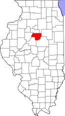
Woodford County, Illinois
| Woodford County, Illinois | |
| Map | |
 Location in the state of Illinois |
|
 Illinois's location in the U.S. |
|
| Statistics | |
| Founded | 1841 |
|---|---|
| Seat | Eureka |
| Largest city | Eureka |
| Area - Total - Land - Water |
543 sq mi (1,406 km²) 528 sq mi (1,367 km²) 15 sq mi (38 km²), 2.73% |
| Population - (2000) - Density |
35,469 67/sq mi (26/km²) |
| Time zone | Central: UTC-6/-5 |
Woodford County is a county located in the state of Illinois, USA. As of 2000, the population was 35,469. Its county seat is Eureka[1].
Woodford County is part of the Peoria, Illinois Metropolitan Statistical Area.
Contents |
Geography
According to the U.S. Census Bureau, the county has a total area of 543 square miles (1,406 km²), of which, 528 square miles (1,367 km²) of it is land and 15 square miles (38 km²) of it (2.73%) is water.
Adjacent counties
- Marshall County (north)
- LaSalle County (northeast)
- Livingston County (east)
- McLean County (southeast)
- Tazewell County (southwest)
- Peoria County (west)
History
Woodford County was formed in 1841 out of Tazewell and McLean Counties. The County was named for Woodford County, Kentucky, which was named for General William Woodford, who was with General George Washington at Valley Forge.
Demographics
| Historical populations | |||
|---|---|---|---|
| Census | Pop. | %± | |
| 1900 | 21,822 |
|
|
| 1910 | 20,506 | −6% | |
| 1920 | 19,340 | −5.7% | |
| 1930 | 18,792 | −2.8% | |
| 1940 | 19,124 | 1.8% | |
| 1950 | 21,335 | 11.6% | |
| 1960 | 24,579 | 15.2% | |
| 1970 | 28,012 | 14% | |
| 1980 | 33,320 | 18.9% | |
| 1990 | 32,653 | −2% | |
| 2000 | 35,469 | 8.6% | |
| IL Counties 1900-1990 | |||
As of the census[2] of 2000, there were 35,469 people, 12,797 households, and 9,802 families residing in the county. The population density was 67 people per square mile (26/km²). There were 13,487 housing units at an average density of 26 per square mile (10/km²). The racial makeup of the county was 98.47% White, 0.25% Black or African American, 0.17% Native American, 0.31% Asian, 0.01% Pacific Islander, 0.14% from other races, and 0.65% from two or more races. 0.68% of the population were Hispanic or Latino of any race. 45.9% were of German, 9.5% American, 9.0% English and 8.7% Irish ancestry according to Census 2000.
There were 12,797 households out of which 35.40% had children under the age of 18 living with them, 67.50% were married couples living together, 6.60% had a female householder with no husband present, and 23.40% were non-families. 20.50% of all households were made up of individuals and 10.40% had someone living alone who was 65 years of age or older. The average household size was 2.69 and the average family size was 3.12.
In the county the population was spread out with 26.70% under the age of 18, 8.70% from 18 to 24, 26.20% from 25 to 44, 23.60% from 45 to 64, and 14.80% who were 65 years of age or older. The median age was 38 years. For every 100 females there were 95.50 males. For every 100 females age 18 and over, there were 92.90 males.
The median income for a household in the county was $51,394, and the median income for a family was $58,305. Males had a median income of $42,150 versus $25,251 for females. The per capita income for the county was $21,956. About 2.90% of families and 4.30% of the population were below the poverty line, including 5.80% of those under age 18 and 4.20% of those age 65 or over.
Presidential election voting
Woodford County is among the most solidly Republican counties in Illinois when it comes to Presidential elections. The last Republican to receive less than 50% of the county's vote was George H. W. Bush in 1992 who still won the county.[3] In 1964 Barry Goldwater won the county despite losing the state by nearly 19%.[4] In a related vein Ronald Reagan, although Democratic at the time, attended Eureka College which is located in the county.
Cities and towns
|
|
|
Townships
Woodford County is divided into these townships:
|
|
|
References
- ↑ "Find a County". National Association of Counties. Retrieved on 2008-01-31.
- ↑ "American FactFinder". United States Census Bureau. Retrieved on 2008-01-31.
- ↑ The New York Times Electoral Map
- ↑ David Leip Presidential Atlas
|
||||||||||||||||||||
|