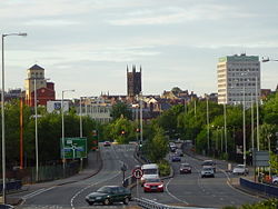
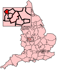
Wolverhampton
| Wolverhampton | |||
| — City — | |||
| City of Wolverhampton | |||
 |
|||
|
|||
| Nickname(s): W'ton, Wolves | |||
| Motto: Out of darkness cometh light | |||
 |
|||
| Coordinates: | |||
| Sovereign state | United Kingdom | ||
|---|---|---|---|
| Constituent country | England | ||
| Region | West Midlands | ||
| Ceremonial county | West Midlands | ||
| Admin HQ | Wolverhampton city centre | ||
| Founded | 985 | ||
| Founder | Lady Wulfruna | ||
| Named for | Lady Wulfruna | ||
| Government | |||
| - Type | Metropolitan borough | ||
| - Governing body | Wolverhampton City Council | ||
| - MPs | Rob Marris (L) Pat McFadden (L) Ken Purchase (L) |
||
| Area | |||
| - Total | 26.8 sq mi (69.44 km²) | ||
| Population (2006 est.) | |||
| - Total | 236,000 (Ranked 46th) | ||
| - Density | 8,824.1/sq mi (3,407/km²) | ||
| - Ethnicity (United Kingdom Estimate 2005) [1] |
76.5% White 14.7% S.Asian 4.8% Black 1.1% Chinese or other 2.9% Mixed Race |
||
| Time zone | Greenwich Mean Time (UTC+0) | ||
| - Summer (DST) | British Summer Time (UTC+1) | ||
| Postcode | WV | ||
| Area code(s) | 01902 | ||
| ISO 3166-2 | GB-WLV | ||
| ONS code | 00CW | ||
| OS grid reference | SO915985 | ||
| NUTS 3 | UKG35 | ||
| Website: http://www.wolverhampton.gov.uk | |||
Wolverhampton (pronunciation) is a city and metropolitan borough of the West Midlands, England. In 2004, the local government district had an estimated population of 239,100;[2] the wider Urban Area had a population of 251,462,[3] which makes it the 13th most populous city in England.
Historically a part of Staffordshire, and forming part of the metropolitan county of the West Midlands from 1974, the city is commonly recognised as being named after Lady Wulfruna, who founded the town in 985: its name coming from Anglo-Saxon Wulfrūnehēantūn = "Wulfrūn's high or principal enclosure or farm".[4] Alternatively, the city may have earned its original name from a local Danish leader who was called Wulfere.[5] Nevertheless, the name Wulfruna is commonly used in the city - for example, for the Wulfrun Centre or for Wulfrun Hall.
The city's name is often abbreviated to "W'ton"[6] or "Wolves".[7][8] The city council's motto is "Out of darkness, cometh light".[9] People from Wolverhampton are known as Wulfrunians.
The city grew initially as a market town with specialism within the woollen trade. During and after the Industrial Revolution, the city became a major industrial centre, with mining (mostly coal, limestone and iron ore) as well as production of steel, japanning, locks, motorcycles and cars - including the first vehicle to hold the Land speed record at over 200mph. Today, the major industries within the city are both engineering based (including a large aerospace industry) and within the service sector.[10]
Contents |
History
A local tradition states that King Wulfhere of Mercia founded an abbey of St Mary at Wolverhampton in 659. Proof of such an abbey has not been found to date.[11]
Wolverhampton is recorded as being the site of a decisive battle between the Saxons and Danes in 910, although sources are unclear as to whether the battle itself took place in Wednesfield or Tettenhall.[12] The Saxons claimed a decisive victory and the field of Woden is recognised by numerous place names in Wednesfield.[13][14]

In 985, King Ethelred the Unready granted lands at a place referred to as Heantun to Lady Wulfruna by royal charter,[15] and hence founding the settlement.
In 994, a monastery was consecrated in Wolverhampton for which Wulfruna granted land at Upper Arley in Worcestershire, Bilston, Willenhall, Wednesfield, Pelsall, Ogley Hay near Brownhills, Hilton near Wall, Hatherton, Kinvaston, Hilton near Wolverhampton, and Featherstone.[15] This became the site for the current St. Peter's Church.[16] A statue of Lady Wulfruna, sculpted by Sir Charles Wheeler, can be seen on the stairs outside the church.[15]
In 1179, there is mention of a market held in the town, and in 1204 it had come to the attention of King John that the town did not possess a Royal Charter for holding a market. This charter for a weekly market held on a Wednesday was eventually granted on 4 February 1258 by Henry III.[16]
It is held that in the 14th and 15th centuries that Wolverhampton was one of the "staple towns" of the woollen trade,[16] which today can be seen by the inclusion of a woolpack on the city's coat of arms,[17] and by the many small streets, especially in the city centre, called "Fold" (examples being Blossom's Fold, Farmers Fold, Townwell Fold and Victoria Fold), as well as Woolpack Street and Woolpack Alley.[16]
In 1512, Sir Stephen Jenyns, a former Lord Mayor of London and a twice Master of the Worshipful Company of Merchant Taylors, who was born in the city, founded Wolverhampton Grammar School, one of the oldest active schools in Britain.[18]
Wolverhampton suffered two Great Fires: the first in April 1590, and the second in September 1696. Both fires started in today's Salop Street. The first fire lasted for five days and left nearly 700 people homeless, whilst the second destroyed 60 homes in the first five hours. This second fire led to the purchase of the first fire engine within the city in September 1703.[16]
From the 16th century onwards, Wolverhampton became home to a number of metal industries including lock and key making and iron and brass working. In January 1606, two farmers, Thomas Smart and John Holyhead of Rowley Regis, were hanged in High Green, now Queen Square, for sheltering some of the Gunpowder Plotters who had fled to the Midlands. The pair played no part in the original plot but nevertheless suffered the traitor's death of being hanged, drawn and quartered on butcher's blocks set up in the square a few days before the execution of Guy Fawkes and several other plotters in London.[16]
In Victorian times, Wolverhampton grew to be a wealthy town mainly due to the huge amount of industry that occurred as a result of the abundance of coal and iron deposits in the area. The remains of this wealth can be seen in local houses such as Wightwick Manor and The Mount (both built for the Mander family, prominent varnish and paint manufacturers), and Tettenhall Towers. Many other houses of similar stature were built only to be demolished in the 1960s and 1970s.
In the 19th century the city saw much immigration from Wales and Ireland, following the Irish Potato Famine. Wolverhampton is home to a large proportion of the Sikh community, who settled there during the period (1940-1970) from the Indian state of Punjab. Today, the Sikh community in Wolverhampton is roughly 8% of the city's population.
Wolverhampton gained its first parliamentary representation as part of the Reform Act 1832, when it was one of 22 large towns that were allocated two Members of Parliament. It was incorporated as a municipal borough on March 15 1848 under the Municipal Corporations Act 1835 before becoming a County Borough in 1889.[19] The United Kingdom government announced on December 18, 2000 that Wolverhampton would be granted city status, making it one of three "Millennium Cities",[20] an honour that had been unsuccessfully applied for in 1953, 1966, 1977[21], 1985[22] and 1992.[21] Wolverhampton also made an unsuccessful application for a Lord Mayor in 2002.[21]
In 1866, a statue was erected in memory of Prince Albert, the unveiling of which brought Queen Victoria to Wolverhampton.[23] The unveiling of the statue was the first public appearance Queen Victoria had made since the funeral of her husband the Prince Consort. A 40-foot (12 m) tall archway made of coal was constructed for the visit. The Queen was so pleased with the statue that she knighted the then-mayor, an industrialist named John Morris. Market Square, originally named High Green, was renamed Queen Square in honour of the visit. The statue replaced a Russian cannon captured from Sevastopol during the Crimean War in 1855,[19] and remains standing in Queen Square.
The railways reached Wolverhampton in 1837, with the first station located at Wednesfield Heath, now Heath Town on the Grand Junction Railway.[24] This station was demolished in 1965, but the area exists as a nature reserve just off Powell Street.[25] Wolverhampton Railway Works was established in 1849 for the Shrewsbury and Birmingham Railway and became the Northern Division workshop of the Great Western Railway in 1854.[26]
Wolverhampton High Level station (the current main railway station) opened in 1852, but the original station was demolished in 1965 and then rebuilt.[27] Wolverhampton Low Level station opened on the Great Western Railway in 1855. The site of the Low Level station, which closed to passengers in 1972 and completely in 1981, is currently undergoing redevelopment.[28] Wolverhampton St George's (in the city centre) is now the northern terminus for the Midland Metro light rail system. Wolverhampton was one of the few towns to operate surface contact trams and the only town to use the Lorain Surface Contact System.[29] Trolleybuses appeared in 1923 and in 1930 for a brief period, Wolverhampton was the world's largest trolleybus system.[30] The last trolleybus ran in 1967, just as the railway line through the High Level station was converted to electric operation.
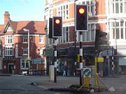
England's first automatic traffic lights could be seen in Princes Square, Wolverhampton in 1927.[31] The modern traffic lights at this location have the traditional striped poles to commemorate this fact.
In 1918, David Lloyd George, the British Prime Minister, announced he was calling a General Election at "The Mount" in Tettenhall Wood.[32] Lloyd George also made his "Homes fit for heroes" speech at Wolverhampton Grand Theatre in the same year.[33] It was on the idea of "Homes fit for heroes" that Lloyd George was to fight the 1918 "Coupon" General Election.
Wolverhampton was represented politically in Victorian times by the Liberal MP Charles Pelham Villiers, a noted free trade supporter, who was also the longest serving MP in parliamentary history. Lord Wolverhampton, Henry Hartley Fowler was MP for Wolverhampton at the turn of the century. Sir Geoffrey Le Mesurier Mander, a member of the Mander family, was Liberal MP for Wolverhampton East from 1929 to 1945, distinguished for his stance against Appeasement and as a supporter of the League of Nations; known as "the last of the Midland radicals". More recent members have included the Conservative mavericks Enoch Powell and Nicholas Budgen. In 2005, former Bilston councillor and MP for Wolverhampton South East, Dennis Turner entered the House of Lords as Lord Turner of Bilston.
Geography
Wolverhampton lies northwest of its larger near-neighbour Birmingham, and forms the second largest part of the West Midlands conurbation.[34] To the north and west lies the Staffordshire and Shropshire countryside.
| for Wolverhampton | |||||||||||||||||||||||||||||||||||||||||||||||
|---|---|---|---|---|---|---|---|---|---|---|---|---|---|---|---|---|---|---|---|---|---|---|---|---|---|---|---|---|---|---|---|---|---|---|---|---|---|---|---|---|---|---|---|---|---|---|---|
| J | F | M | A | M | J | J | A | S | O | N | D | ||||||||||||||||||||||||||||||||||||
|
63
7
1
|
44
7
1
|
51
10
3
|
49
12
4
|
53
16
6
|
59
18
9
|
47
21
11
|
58
21
11
|
64
18
9
|
61
14
6
|
62
10
3
|
67
7
2
|
||||||||||||||||||||||||||||||||||||
| temperatures in °C precipitation totals in mm source: "Averages 1971-2000". Met Office. |
|||||||||||||||||||||||||||||||||||||||||||||||
|
Imperial conversion
|
|||||||||||||||||||||||||||||||||||||||||||||||
Wolverhampton city centre falls outside of the area traditionally known as the Black Country, although some districts such as Bilston and Heath Town fall within the Black Country coalfields, leading to confusion as to whether the entire city falls within the region. Modern usage has tended towards using the term to refer to the western part of the West Midlands county, excluding Birmingham, Solihull and Coventry. Examples would be UK Government regional bodies such as the Black Country Development Corporation, under whose remit the city fell.
The city lies upon the Midlands Plateau at approximately 120 m (394 ft) above sea level.[35] There are no major rivers within the city, although the River Penk and River Tame (tributaries of the River Trent) rise in the city, as does Smestow Brook, a tributary of the River Stour, and thence the River Severn. This means that the city lies astride one of the major drainage divides of England.
The geology of the city is complex, with a combination of Triassic and Carboniferous geology; specifically Bunter and Keuper sandstone, and Upper and Middle Coal measures. There is also an area of dolerite deposits.[36]
Climate
Wolverhampton's climate is quite temperate with average maximum temperatures in July being around 21 °C (70 °F) with the minimum daytime temperature in January being around 6.5 °C (43.7 °F).
The Met Office's nearest observation station is at Penkridge, about 5 miles (8 km) north of the city.
Areas of the city
Localities in the City of Wolverhampton include:
Nearby places
See also: The Black Country. GovernanceThe vast majority of Wolverhampton is governed locally by Wolverhampton City Council, although some small areas are governed by South Staffordshire District Council. The area administered by the City Council is represented in the national United Kingdom parliament by three MPs representing Wolverhampton South West, Wolverhampton South East and Wolverhampton North East constituencies, with the areas administered by South Staffordshire District Council being represented by South Staffordshire constituency. The entire city is part of the West Midlands constituency of the European Parliament. Since the abolition of West Midlands County Council in 1986, Wolverhampton City Council has been effectively a unitary authority. South Staffordshire District Council is a two-tier authority, with some services provided by Staffordshire County Council. Civic historyWolverhampton gained the beginnings of modern local government in 1777, when the Wolverhampton Improvement Act was passed by Parliament. This allowed for the establishment of 125 Town Commissioners who undertook a variety of local improvement work such as punishing bear baiting, improving drainage, widening streets and by the end of the century street lighting had been provided in the at every street corner and over the doorway of every inn, and water supply had been improved by the sinking of ten new wells and the provision of a great water tank in the market place. Policing had been improved with the appointment of ten watchmen and attempts were also made to regulate the markets and inspect hazardous food.[4][37] Wolverhampton parliamentary borough was created by the Reform Act 1832, which included areas currently located with the Metropolitan Boroughs of Dudley, Walsall and Sandwell such as Wren's Nest, New Invention and Gornal. It was one of 22 large towns that returned two Members of Parliament. Under the Redistribution of Seats Act 1885, the original borough was replaced by three new single-member constituencies: Wolverhampton East, Wolverhampton South and Wolverhampton West.[38] In 1837, Wolverhampton Borough Police was formed. It was disestablished in 1966,and the larger West Midlands Constabulary, which covered not only Wolverhampton but the County Boroughs of Walsall, Dudley, West Bromwich and Warley took over its duties and was headquartered in the city. This force was then replaced in 1974 with the West Midlands Police.[39] Wolverhampton was incorporated as a municipal borough in 1849 under the Municipal Corporations Act 1835.[40] The town was then made a County Borough in 1889 under the Local Government Act 1888.[40] In 1933, the boundaries of the borough expanded, taking in areas from Cannock Rural District and Seisdon Rural District, with very little of the surrounding urban area being affected,[41] with only Heath Town Urban District being abolished. The bulk of the formerly independent urban districts of Bilston (a borough itself after 1933), Tettenhall and Wednesfield were added to the borough in 1966, along with part of the urban district of Coseley and small parts from Sedgley and Willenhall.[41] Wolverhampton was one of only two County Boroughs (the other being Liverpool) to have no changes made to the boundary during the 1974 reorganisation of local government, the borough already having a population larger than the 250,000 required for education authorities. This contrasted with both the Redcliffe-Maud Report, and the initial White Paper for the 1974 reforms[42] where large areas of the present South Staffordshire district were to be added to the borough. During the 1974 reforms it was placed within the West Midlands Metropolitan County. Wolverhampton was also a Royal Peculiar covering a large area.[43] Wolverhampton City CouncilThe council offices are located in the Civic Centre, which is located in St. Peter's Square in the city centre.[44] No political party currently has a majority on the City Council, and it is currently controlled by a coalition between the Conservative Party and the Liberal Democrat Party.[45] The Labour Party have been in majority on the council since 1974, with the exceptions of 1978-1979, 1987, 1992-1994 and 2008-2010.[46] Councillor Christine Mills is Mayor of Wolverhampton for 2007-08.[47] Wolverhampton City Council was assessed by the Audit Commission and judged to be "improving well" in providing services for local people; this rating was given to 59% of local authorities. Overall, the council was awarded "three star" status meaning it was "performing well" and "consistently above minimum requirements", similar to 46% of all local authorities. It was noted that it was rated as "good" for children's and young people's services; whilst the Supporting People programme was judged to be "poor".[48] The Vision Statement for the council is "Wolverhampton City Council, Leading, Supporting and Inspiring our City. Proud to be of service today and rising to the challenges of tomorrow."[49]
WardsThere are 20 wards of Wolverhampton City Council:
A map showing the ward boundaries is available here. Coat of armsThe coat of arms of Wolverhampton City Council was granted on 31 December 1898, on the occasion of the 50th anniversary of the foundation of the council. Prior to this date, there was a former coat of arms in use since 1848, though these arms were never officially granted.[17] The various symbols within the arms are representative of the history of the city. The book represents the education within the city, specifically the 16th century Wolverhampton Grammar School;[17] the woolpack represents the mediaeval woollen trade within the city;[17] the column is a representation of the Saxon pillar that can be found within the churchyard of St. Peter's Collegiate Church in the city centre;[17] whilst the keys are representative of the church itself and its dedication to St. Peter.[17] The padlock represents one of the major industries of the area at the time of the granting of the arms - that of lock-making;[17] whilst the brazier at the top is indicative of the general metal-working industries in the area.[17] The cross is ascribed to King Edgar.[17] The motto on the coat of arms is 'Out of Darkness Cometh Light'.[17] Demographics
The 2001 Census gives the Wolverhampton urban sub-area as the second largest in the West Midlands conurbation. The figure given for Wolverhampton is 251,462 which also includes areas outside the borough (236,582). By this reckoning it is the 13th largest city in England. Wolverhampton has a relatively old population, with the proportion of the population aged 60 and over being larger than the proportion of children aged 15 or under. The proportion of young people in the city has decreased between the 1991 Census and the 2001 Census by 7.4%, compared with an England and Wales average increase of 1.7%. The proportion of females within the city (51%) is slightly higher than that of males (49%). Of adults aged over 16, 31.3% were single, 43.4% were married for the first time, 7.7% divorced and 9.6% were widowed.[73] Wolverhampton is an ethnically diverse city, with nearly a quarter (24.6%) of the population being of black or minority ethnic (BME) origin and 22.2% of residents classifying themselves as non-white in the 2001 Census, with the largest non-white category being Indian at 12.3%, which compares with a West Midlands average of 6.2% and an England and Wales average of 2.1%. Wolverhampton's multi-cultural nature is reflected in an above–average level of non-Christian religions (13.6% of people, compared with 5.5% for England and Wales), with Sikhs accounting for 7.6% of Wolverhampton's population, the fourth largest Sikh community in England and Wales. The number of Hindus is also higher than the England and Wales average (Wolverhampton 3.9%, England and Wales 1.1%), while the proportion of people following Judaism and Islam was below the average for England and Wales. The figure for Buddhism is in line with the England and Wales average. According to the 2001 Census, 62.2% of the population of the city between the ages of 16 and 75 are considered to be economically active, with 37.5% holding full time employment, 11.3% part time employment, 5.4% self-employed and 2.6% being full-time students with other employment. Of those who are economically inactive, 14.4% were retired, 7.1& were looking after homes or families, whilst 5.1% were full-time students without other employment.[74] Degree-level qualifications (or above) were held by 13.6% of the population (compared with 19.8% in England and Wales), while 40.7% possessed no qualifications (compared with 29.1& across England and Wales).[75] Wolverhampton is within the top 11% of local authority areas in England and Wales (excluding London Boroughs) for public transport use for travelling to work at 16% of the total. 63% used private transport, either as a driver or passenger, 13% cycled or travelled on foot, whilst 8% worked from home.[76] Car ownership is lower than the average for England and Wales with 35.2% of households not owning a car, compared with 26.8% nationally. Single car ownership is in line with national averages (Wolverhampton 42.9%, England and Wales 43.8%), while the proportion of households owning more than one car is lower than the national average.[77] According to the 2001 Census, Wolverhampton is one of the 243 Travel to Work Areas in the United Kingdom. There were 163,378 people resident within the TTWA who were in employment, and 157,648 jobs. The TTWA extends outside the city itself into the local authority districts of Dudley, Walsall, South Staffordshire and Bridgnorth and has an area of 405 square km.[78] According to Eurostat data, Wolverhampton has its own Larger Urban Zone,[79][80] which had a total resident population in 2004 of 344,400.[81]
Economy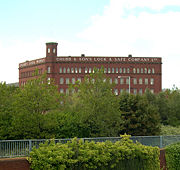
The Chubb Building, Fryer Street
Traditionally, Wolverhampton's economy has been dominated by engineering and manufacturing industries. However, today the economy is dominated by the service sector, with 79.6% of the city's employment being in this area. The major subcomponents of this sector are in public administration, education and health (32% of the total employment), while distribution, hotels and restaurants take up 25.3%, and finance and IT takes up 13.9%. The largest non-service industry is that of manufacturing (15.5%). Perhaps surprisingly, 6.2% of the total employment is related to the tourism industry.[88] The largest single employer within the city is Wolverhampton City Council.[89] which has over 12,000 staff[90] Other large employers within the city include:
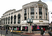
Beatties Wolverhampton.
Wolverhampton is one of the major retail centres in the West Midlands Region, being placed at fifth largest in 2005, with an annual turnover of £380 million.[91] Many of the traditional industries in the city have closed or dramatically downsized. Famous companies once based in the city include:
Unemployment within the City Council area at November 2007 was 4.7%,[92] which varied across wards, with three wards having rates of over 7% (being Ettingshall, St Peter's and Heath Town), and three wards with rates less than 3% (Penn, Tettenhall Wightwick and Tettenhall Regis). TransportRoadWolverhampton is near to several motorways, with the following being within 7 miles (11 km) of the city centre:

Wolverhampton Inner Ring Road
There have also been several motorways proposed near to the city that have not been constructed, or have been constructed to a lower standard:
The main roads radiating from the city centre meet the city's Ring Road, which is acts to keep through traffic out of the city centre itself. Other major roads passing through the city include:
Public transport
Wolverhampton railway station
The city's railway station is served by the West Coast Main Line. It has regular rail services to London, Birmingham and Manchester, as well as many other major cities in the UK. The Wrexham, Shropshire and Marylebone Railway has started its train service to London, via Bescot. The railway station is due for redevelopment, with the main station buildings being demolished in a project called Wolverhampton Interchange. It is due to open in 2012.[101] There are many local services, including those on the Cambrian Line, the Walsall to Wolverhampton Line, the Wolverhampton to Shrewsbury Line and the Rugby-Birmingham-Stafford Line. There are also many closed stations within the city, including Wolverhampton Low Level, the most northerly broad gauge station on the Great Western network. The city's bus station is situated adjacent to the railway station, providing an interchange between the two modes of transport. Buses in the city are regulated by West Midlands Passenger Transport Executive and the largest provider of services is National Express West Midlands. Metro
Midland Metro terminus
The Midland Metro, a light rail tram system, currently connects Wolverhampton St. George's to Birmingham Snow Hill station via West Bromwich and Wednesbury, mostly following the former Birmingham Snow Hill-Wolverhampton Low Level Line. There are plans for further lines within the city, with both a city centre loop and a line to Walsall via Wednesfield and Willenhall, mostly following the route of the closed Wolverhampton and Walsall Railway.[102] AirWolverhampton's original airport was at Pendeford, opened in 1938 and closed on 31 December 1970.[103] The current Wolverhampton Airport, renamed from Halfpenny Green, is a small general aviation airfield located 8 miles (12.9 km) southwest of the city. Expansion of the airport has been suggested, but this has been successfully resisted by local residents. The nearest major airport is Birmingham International Airport, approximately 25 miles (40.2 km) away. The airport is easy to reach by train, with a direct express service to it. By car, it can actually sometimes be quicker to reach Manchester Airport instead, due to traffic delays on the M6 eastbound motorway towards Birmingham International. WaterwaysThere are no navigable rivers within the city, but there are many miles of canal network: the Birmingham Main Line Canal, the Staffordshire and Worcestershire Canal, the Shropshire Union Canal and the Wyrley & Essington Canal are all to be found. CyclingMost places in the borough and some of the neighbouring villages in South Staffordshire are within easy reach by pedal cycle of the city centre and terrain is moderately hilly. Climbs tend to be of two to three minutes duration. Cycling benefits from the 20 miles per hour (32 km/h) city centre within the Ring Road and a number of routes that use quieter roads and paths to avoid the ten 'A' roads that radiate from the Ring Road. Wolverhampton is on the Smethwick to Telford section of Sustrans National Cycle Network Route 81.[104] This follows the Birmingham Main Line Canal towpath from Smethwick to Broad Street Basin, Wolverhampton where the route splits in two. The choice here is between riding the 21 locks section of the Birmingham Main Line Canal to Aldersley Junction or taking the Cross-City route braid in order to visit the city centre, West Park or Smestow Valley Leisure Ride before returning to Aldersley Junction. NCN81 continues to Autherley Junction along the towpath of the Staffordshire and Worcestershire Canal and then along the east bank towpath of the Shropshire Union Canal as far as Pendeford Mill Lane before turning to Bilbrook in Staffordshire. The lanes of nearby South Staffordshire and east Shropshire provide ideal cycle touring conditions.[105] CultureMusicThe rock groups Slade, Cornershop, The Mighty Lemon Drops, Ned's Atomic Dustbin and Babylon Zoo came from Wolverhampton, as do soul/ R&B singer Beverley Knight and Drum and bass guru Goldie. Musician Jamelia lives in Wolverhampton with her mother and daughter. Wolverhampton has a number of live music venues; the biggest is technically the football ground, Molineux Stadium, which was used for a Bon Jovi concert in 2003,[106] but the biggest indoor venue is Wolverhampton Civic Hall, with a standing capacity of 3,000.[107] Second to that is Wulfrun Hall (part of the same complex as the Civic Hall, which is owned and operated by the City Council) which has a standing capacity of just over 1,100.[108] There are also a number of smaller venues with capacities between 100 and 250: the Little Civic and the Wolverhampton Varsity being the most long-standing of these. The 18th century church of St John's-in-the-Square is a popular venue for smaller scale classical concerts. The city is also home to Regent Records, a choral and organ music recording company.[109] The city's main choral groups include the City of Wolverhampton Choir,[110] (a choral society founded as the Wolverhampton Civic Choir in 1947) and the Choir of St. Peter's Collegiate Church,[111] who perform cathedral style church services each week during term time. Arts and museums
Wolverhampton Art Gallery
The Grand Theatre on Lichfield Street is Wolverhampton's largest theatre, opening on 10 December 1894. It was designed by C. J. Phipps and completed within six months. Included amongst the people to have appeared at the theatre are Henry Irving, Charlie Chaplin and Sean Connery. It was also used by politicians including Winston Churchill and David Lloyd George. The theatre was closed between 1980 and 1982.[112] The Arena Theatre on Wulfruna Street, within the University of Wolverhampton is the secondary theatre, seating 150. It hosts both professional and amateur performances.[113] Cinema is catered for by a multiplex Cineworld located at Bentley Bridge, Wednesfield,[114] and a smaller cinema, The Light House, housed in the former Chubb Buildings on Fryer Street.[115] Cineworld caters mainly for popular tastes, showing Hollywood films and other big-budget films as well as some Bollywood films whilst The Light House shows a range of older and subtitled films as well as some selected new releases. The Light House has also played host to visual art shows, and incorporates a small café. The City's Arts & Museums service, run by the council, covers three sites: Wolverhampton Art Gallery, home to England's biggest Pop art collection after that held at the Tate;[116] Bantock House, a fine historic house with Edwardian interior with a museum of Wolverhampton located within Bantock Park;[117] Bilston Craft Gallery with exhibitions of contemporary crafts.[118] The Black Country Living Museum, situated in nearby Dudley, has a large collection of artefacts and buildings from across the Black Country, including an extensive collection associated with the city.[119] Eagle Works Studio situated in Chapel Ash, has infrequent amateur exhibitions and group shows.[120] The National Trust owns two properties on the edge of the city that are open to the public: Wightwick Manor, which is a Victorian manor house and one of only a few surviving examples of a house built and furnished under the influence of the Arts and Crafts movement,[121] and Moseley Old Hall, which is famous as one of the resting places of Charles II of England during his escape to France following defeat at the Battle of Worcester in 1651.[122] Nearby museums also include the Royal Air Force Museum, at RAF Cosford, the Boulton Paul Association at Pendeford[123] and the RAF Fire Service Museum at Wolverhampton Airport.[124] LibrariesLocated on the corner of Garrick Street and St George's Parade, Wolverhampton Central Library is a Grade II listed building, designed by architect Henry T. Hare and opened in 1902. It was originally commissioned to commemorate Queen Victoria's Diamond Jubilee using funds raised by the Mayor, Alderman S Craddock, and by a grant of £1,000 from Andrew Carnegie. This new library improved public access to information and reading material, replacing its cramped predecessor in the old Garrick Street Police Station.[125] The terricota exterior has a tripartite theme of related, but distinct façades. The entrance façade is the architect’s centrepiece and is decorated with a frieze under the triple window which carries the Royal Coat of Arms and the Wolverhampton Coat of Arms. The other two façades celebrate English literary giants; Chaucer, Dryden, Pope, Shelley, Byron and Spenser on one side and Milton and Shakespeare on the other.[125] An extension for a newsroom and a students’ room was added in 1936 followed by a small brick and concrete extension at the rear in the 1970s.[125] Wolverhampton City Council also operate 19 branch libraries within the city.[126] MediaWolverhampton is home to the Express & Star newspaper, which boasts of having the largest circulation of any provincial daily evening newspaper in the UK.[127] The city is also home to four radio stations, WCR FM, 107.7 The Wolf, Beacon Radio and Classic Gold WABC. In December 2005, the BBC commissioned the poet Ian McMillan to write a poem about Wolverhampton, along with four other towns which "had a reputation they didn't deserve".[128] Education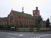
Wolverhampton Grammar School
Wolverhampton Girls' High School is a well known selective school which was has produced top of league table results within Wolverhampton.[129] Notable old girls include the former English Women's Cricket Captain Rachael Heyhoe-Flint and Baroness Hayman, first Lord Speaker of the House of Lords. Wolverhampton Grammar School was founded in 1512, making it one of the oldest active schools in the UK.[130] Old boys include Mervyn King, Governor of the Bank of England since July 2003, and Sir David Wright, former British Ambassador to Japan. Other notably historic schools include The Royal Wolverhampton School (founded in 1850),[131] St Peter's Collegiate School (founded in 1847)[132] and Tettenhall College (1863),[133] which educated the winner of Nobel Prize for Chemistry, Professor Sir Arthur Harden. In 1835, the Wolverhampton Mechanics' Institute was founded, and its lineage can be traced via the Wolverhampton and Staffordshire Technical College (1935), to The Polytechnic, Wolverhampton (1969) to today's University of Wolverhampton, given university status in 1992. The main university campus is in the city centre, with other campuses at Compton, and in the nearby towns of Walsall and Telford. Sport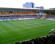
Molineux Stadium, home of Wolverhampton Wanderers
FootballWolverhampton is represented in the Football League Championship by Wolverhampton Wanderers F.C.. "Wolves", as they are known, are one of the oldest English football clubs, and were one of the 12 founder members of the Football League. Their most successful period was the 1950s, where they won three Football League Championships (then the highest division) and two FA Cups, and were involved in the earliest European friendlies. They were hailed by the press as "The Unofficial World Champions" after one of their most famous victories, against Budapest Honvéd FC of Hungary. They were also the first English team to play in the Soviet Union. These victories instigated the birth of the European Cup competition which later evolved into the UEFA Champions' League (see European Cup and Champions League History). In total, they have won three Football League Championships (prior to the top division becoming the Premier League), four FA Cups, have two League Cup victories and many other minor honours, including reaching the UEFA Cup Final in 1972, and appearances in the last eight of both the UEFA European Cup, and the European Cup Winners' Cup, but have spent just one season in the top division since 1984. They are also the only club to have won five different league titles (Division 1, Division 2, Division 3, Division 4 and Division 3 (North)). The city's second club, Wolverhampton Casuals F.C. play in the West Midlands (Regional) League Premier Division. AthleticsWolverhampton's Aldersley Leisure Village is also home to Wolverhampton & Bilston Athletics Club, which was formed in 1967 with a merger between Wolverhampton Harriers and Bilston Town Athletic Club. They have won the National League Division One for men from 1975 to 1982, and the Men's National Cup finals in 1976, 1977, 1979 and 1980. It also represented Britain in the European Clubs Cup from 1976 to 1983 with the best finishing position of third.[134] Olympic Medallists in athletics Denise Lewis, Tessa Sanderson, Kathy Smallwood-Cook, Garry Cook and Sonia Lannaman[135] all lived within the city. CyclingWolverhampton Wheelers is the city's oldest cycling club (formed in 1891), and was home to Hugh Porter who won four world championship pursuit medals; and Percy Stallard who has been credited with bringing cycle road racing to Britain when he held the Llangollen to Wolverhampton race on June 7, 1942.[136] Wolverhampton has also hosted the Tour of Britain, with a stage start in 2006 and a stage finish in 2007. Horse and greyhound racingWolverhampton Racecourse is located at Dunstall Park, just to the north of the city centre. This was one of the first all-weather horse racing courses in the UK and is Britain's only floodlit horse race track. There is also greyhound racing at Monmore Green. West Park, a large park near the city centre, was converted from a racecourse. Motor sports
Sunbeam 1000HP at National Motor Museum in Beaulieu, UK
Le Mans 24 Hours winner Richard Attwood is from the city. Sunbeam built many early Grand Prix cars and was the only British make to win a Grand Prix in the first half of the 20th century.[137] Sunbeam also built several holders of the Land speed record, including the first vehicle to travel at over 200 miles per hour (322 km/h), the Sunbeam 1000 hp. Kieft Cars built Formula Three cars in the early 1950s. Their best known driver was Stirling Moss.[138] AJS was heavily involved in motorcycle racing either side of World War II, which included winning the 1949 World Championship in the 500cc category. Wolverhampton Wolves, one of the leading Speedway clubs in the UK represents the city, participating in the Elite League at the Monmore Green stadium. Wolverhampton Speedway is one of the oldest speedway tracks in the world that is still in operation being first used, albeit briefly in 1928. The track re-opened in 1950 for a single meeting and in 1952 the Wasps competed in the Third Division on the National League. The track closed early in 1954 and did not re-open until 1961 when the Wolves were introduced to the Provincial League. The track has almost been an ever present ever since and currently operates in the British Elite League.[139] Ole Olsen (in 1971 and 1975) and Sam Ermolenko (in 1993) were riders for the club when thay became World Speedway Champions. Places of interest
St Peter's Church
In and around the city there are a number of places of interest, which include the following:
Famous residents
Statue of Billy Wright outside Molineux Stadium
There are a number of notable people who are associated with Wolverhampton. Political figures include Enoch Powell MP, Sir Charles Pelham Villiers MP - who holds the record for the longest serving MP, Helene Hayman, Baroness Hayman who was the first Lord Speaker within the House of Lords, former Cabinet minister Stephen Byers, David Wright, a former UK Ambassador to Japan and Button Gwinnett, who was a signatory of the US Declaration of Independence in his capacity as Governor of Georgia. There are many sportspeople associated with the city, with footballers such as Billy Wright, Steve Bull, Bert Williams and Jimmy Mullen; along with Percy Stallard and Hugh Porter within the world of cycling, the Olympic medallist swimmer Anita Lonsbrough, racing driver and winner of the 24 hours of Le Mans Richard Attwood and athletes such as Tessa Sanderson and Denise Lewis. Entertainers include actors Nigel Bennett, Frances Barber, Meera Syal and Eric Idle; and musicians Noddy Holder, Jamelia, Beverley Knight, Dave Holland, Maggie Teyte, Edward Elgar, Mitch Harris and Robert Plant; whilst television presenters Suzi Perry, Mark Rhodes and Mark Speight are also associated. Within the area of commerce and industry, Sir Alfred Hickman (founder of Tarmac), Sir Geoffrey Mander, John Marston (founder of the Sunbeam company), John 'Iron Mad' Wilkinson (pioneer of Cast Iron) and Mervyn King Governor of the Bank of England are amongst the most notable. References
External links
|
||||||||||||||||||||||||||||||||||||||||||||||||||||||||||||||||||||||||||||||||||||||||||||||||||||||||||||||||||||||||||||||||||||||||||||||||||||||||||||||||||||||||||||||||||||||||||||||||||||||||||||||||||||||||||||||||||||||||||||||||||||||||||||||||||||||||||||||||||||||||||||||||||||||||||||||||||||||||||||||||||||||||||||||||||||||||||||||||||||||||||||||||||||||||||||||||||||||||||||||||||||||||||||||||||||||||||||||||||||||||||||||||||||||||||||||||||||||||||||||||||||||||||||||||||||||||||||||||||||||||||||||||||||||||||||||||||||||||||||||||||||||||||||||||||||||||||||||||||||||||||||||||||||||||||||||||||||||||||||||||||||||||||||||||||||||||||||||||||||||||||||||||||||||||||||||||||||||||||||||||||||