Wicomico County, Maryland
| Wicomico County, Maryland | |
| Map | |
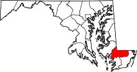 Location in the state of Maryland |
|
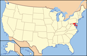 Maryland's location in the U.S. |
|
| Statistics | |
| Founded | 1867 |
|---|---|
| Seat | Salisbury |
| Area - Total - Land - Water |
400 sq mi (1,036 km²) 377 sq mi (976 km²) 23 sq mi (60 km²), 5.66% |
| Population - (2000) - Density |
84,644 225/sq mi (87/km²) |
| Website: www.wicomicocounty.org | |
Wicomico County is located in the southeastern part of the U.S. state of Maryland. It was named for the Wicomico River, which in turn derives from American Indian words wicko mekee, meaning "a place where houses are built," apparently referring to an Indian town on the banks. The county seat is Salisbury. As of 2000, the population was 84,644. It is included in the Salisbury, Maryland Metropolitan Statistical Area.
Contents |
History
Wicomico County was created from Somerset and Worcester Counties in 1867.
Law/Government
Wicomico County was granted a charter form of government in 1964. The legislative functions of government are vested in the County Council. In November 2006, at-large councilman John Cannon (R) was elevated by his peers to the Council Presidency. Executive authority in the county is vested in the office of County Executive. Rick Pollitt (D), former Fruitland City Manager, is the first to hold the title County Executive.
Law enforcement in the county is provided by the Wicomico County sheriff's office. The sheriff, Mike Lewis (R), is an elected official. Municipal police agencies exist in the town of Delmar and the cities of Fruitland and Salisbury.

Geography
According to the U.S. Census Bureau, the county has a total area of 400 square miles (1,035 km²), of which, 377 square miles (977 km²) of it is land and 23 square miles (59 km²) of it (5.66%) is water.
The county is located near the center of the Delmarva Peninsula, and is generally flat, characteristic of the region, with a few small hills in the northeast. The lowest elevation is at sea level and the highest elevation is 98 ft.
Adjacent Counties
- Dorchester County, Maryland (northwest)
- Somerset County, Maryland (southwest)
- Sussex County, Delaware (north)
- Worcester County, Maryland (southeast)
Demographics
As of the census[1] of 2000, there were 84,644 people, 32,218 households, and 21,779 families residing in the county. The population density was 224 people per square mile (87/km²). There were 34,401 housing units at an average density of 91 per square mile (35/km²). The racial makeup of the county was 72.58% White, 23.29% Black or African American, 0.22% Native American, 1.75% Asian, 0.02% Pacific Islander, 0.80% from other races, and 1.34% from two or more races. 2.18% of the population were Hispanic or Latino of any race. 14.6% were of American, 13.3% English, 11.0% German and 9.9% Irish ancestry according to Census 2000.
There were 32,218 households out of which 32.30% had children under the age of 18 living with them, 49.20% were married couples living together, 14.10% had a female householder with no husband present, and 32.40% were non-families. 24.80% of all households were made up of individuals and 9.80% had someone living alone who was 65 years of age or older. The average household size was 2.53 and the average family size was 3.00.
In the county the population was spread out with 24.80% under the age of 18, 11.80% from 18 to 24, 28.00% from 25 to 44, 22.60% from 45 to 64, and 12.80% who were 65 years of age or older. The median age was 36 years. For every 100 females there were 91.00 males. For every 100 females age 18 and over, there were 86.80 males.
The median income for a household in the county was $39,035, and the median income for a family was $47,129. Males had a median income of $32,481 versus $23,548 for females. The per capita income for the county was $19,171. About 8.70% of families and 12.80% of the population were below the poverty line, including 15.60% of those under age 18 and 8.80% of those age 65 or over.
Cities and towns
This county contains the following incorporated municipalities:
- 2 Cities:
- Fruitland (incorporated 1947)
- Salisbury (incorporated 1854)
- 6 Towns:
- Delmar (incorporated 1888)
- Hebron (incorporated 1931)
- Mardela Springs (incorporated 1906)
- Pittsville (incorporated 1906)
- Sharptown (incorporated 1874)
- Willards (incorporated 1906)
The United States Census Bureau recognizes no Census-Designated Places in Wicomico County, which is unusual for Maryland counties, which usually have many unincorporated population centers.
Some areas not listed as Census-Designated Places include:
- Allen
- Bivalve
- Nanticoke
- Parsonsburg
- Powellville
- Quantico
- Tyaskin
- Whitehaven
Education
Colleges and universities
- Salisbury University
- Sojourner-Douglass College
- Wor-Wic Community College
Primary and secondary schools
Wicomico County Public Schools operates public schools in the county.
Miscellaneous
Wicomico County's boundary with Delaware is composed of the Mason-Dixon line and the Transpeninsular Line. The intersection of these two historical lines is the mid-point of the Transpeninsular Line, fixed by Mason and Dixon between 1763 and 1767. The mid-point is located about 8 miles northwest of Salisbury.
The newspaper of record is The Daily Times.
Notable residents
- Joseph Stewart Cottman, (1803-1863), born near Allen, United States Congressman from Maryland[2]
References
- ↑ "American FactFinder". United States Census Bureau. Retrieved on 2008-01-31.
- ↑ Who Was Who in America, Historical Volume, 1607-1896. Chicago: Marquis Who's Who. 1963.
External links
- Wicomico County government
- Wicomico County Convention and Visitor's Bureau
- Wicomico Public Library
- Your Community Link: A Database of Community, Government, and Non-Profit organizations on the Lower Shore
|
|||||||||||||||||
|