Wichita, Kansas
| City of Wichita | |||
 |
|||
|
|||
| Nickname(s): The Air Capital Of The World | |||
 |
|||
| Coordinates: | |||
| Country | United States | ||
|---|---|---|---|
| State | Kansas | ||
| County | Sedgwick | ||
| Government | |||
| - Mayor | Carl Brewer (D) | ||
| Area | |||
| - Total | 138.9 sq mi (359.8 km²) | ||
| - Land | 135.8 sq mi (351.6 km²) | ||
| - Water | 3.2 sq mi (8.2 km²) | ||
| Elevation | 1,299 ft (396 m) | ||
| Time zone | Central (CST) (UTC-6) | ||
| - Summer (DST) | CDT (UTC-5) | ||
| ZIP Codes | 67201-67221, 67223, 67226-67228, 67230, 67232, 67235, 67260, 67275-67278 | ||
| Area code(s) | 316 | ||
| FIPS code | 20-79000[1] | ||
| GNIS feature ID | 0473862[2] | ||
| Website: www.wichita.gov | |||

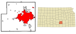
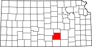
Wichita (pronounced /ˈwɪtʃɪtaː/), is the most populous city in the U.S. state of Kansas, and the county seat of Sedgwick County. The 2006 estimated population of 361,420 makes it the 51st largest city in the U.S.[3] Wichita is located in south central Kansas on the Arkansas River.
Wichita was incorporated in 1870, based on the success of businessmen who came to hunt and trade with native populations. Its position on the Chisholm Trail made it a destination for cattle drives headed north to access railroads to eastern markets. In the 20th century, aircraft pioneers such as Clyde Cessna and Walter Beech began projects that would lead to Wichita's establishment as the "Air Capital of the World". The aircraft corporations Stearman, Cessna, Mooney and Beech were all founded in Wichita in the late 1920s and early 1930s. Cessna and Hawker Beechcraft remain based in Wichita today, along with Learjet and Spirit AeroSystems, and both Airbus and Boeing maintain a workforce in Wichita.
Wichita has also evolved into a cultural and entertainment center. The vital downtown district offers nightclubs, restaurants, shopping centers, museums and parks. A 15,000 seat arena in the middle of Wichita is under construction with completion slated January 2010.[4] Several universities are in Wichita, the largest being Wichita State University with an enrollment of 15,000 students.
In July 2006, CNN/Money and Money magazine ranked Wichita 9th on its list of the 10 best U.S. big cities in which to live.[5] In 2008, MSN Real Estate ranked Wichita 1st on its list of best affordable cities.[6]
Wichita is also the location of one of the most famous, and now solved, serial murder cold cases in US history. The BTK Strangler murdered 10 people between 1974 and 1991. When BTK reemerged in 2004, a task force led by Lt. Kenneth Landwehr identified and arrested compliance officer Dennis Rader, who subsequently pled guilty to all 10 murders.
Contents |
Geography
According to the United States Census Bureau, the city has a total area of 138.9 square miles (360 km2), 3.2 square miles (8.3 km2) of which is water.[1]
Climate
Wichita has a humid subtropical climate (Koppen Cfa) with hot, humid summers and cool to cold, dry winters. Over the course of a year, temperatures range from an average low of about 20 °F (−7 °C) in January to an average high of nearly 93 °F (34 °C) in July. The maximum temperature reaches 90 °F (32 °C) an average of 64 days per year and reaches 100 °F (38 °C) an average of 14 days per year. The minimum temperature falls below 32 °F (0 °C) an average of 108 days per year. The first fall freeze typically occurs between the second week of October and mid-November, and the last spring freeze occurs between the end of March and the final week of April.
The area receives over 30 inches (760 mm) of precipitation during an average year, with the largest share being received in May and June—with a combined 21 days of measurable precipitation. During a typical year, the total amount of precipitation may be anywhere from 22 to 40 inches (560 to 1,000 mm). There are on average 88 days of measurable precipitation per year. Winter snowfall averages almost 17 inches (43 cm), but the median is less than 8 inches (20 cm). Measurable snowfall occurs an average of 11 days per year with at least an inch of snow being received on five of those days. Snow depth of at least an inch occurs an average of 18 days per year.
The area is vulnerable to severe weather, with frequent thunderstorms occurring mainly during the spring and summer months of March-June. These occasionally bring large hail as well as frequent lightning. Sometimes tornadoes occur. The outskirts of Wichita were affected during the Andover, Kansas Tornado Outbreak on April 26, 1991, which spawned an F5 tornado—the most violent of its kind. During the 1999 Oklahoma tornado outbreak, on May 3, 1999, an F4 tornado hit the town of Haysville, which then tracked north and hit the southwest edge of Wichita.
| Month | Jan | Feb | Mar | Apr | May | Jun | Jul | Aug | Sep | Oct | Nov | Dec | Year |
|---|---|---|---|---|---|---|---|---|---|---|---|---|---|
| Temperatures (°F) | |||||||||||||
| Mean high | 40.1 | 47.2 | 57.3 | 66.9 | 76.0 | 87.1 | 92.9 | 91.6 | 82.2 | 70.2 | 54.5 | 43.1 | 67.4 |
| Mean low | 20.3 | 25.3 | 34.4 | 43.7 | 54.0 | 63.9 | 69.1 | 67.9 | 59.3 | 46.9 | 33.9 | 24.0 | 45.2 |
| Highest recorded | 75 (2002) |
87 (1996) |
92 (1916) |
98 (1893) |
100 (1996) |
110 (1980) |
113 (1954) |
114 (1936) |
108 (2000) |
97 (2006) |
86 (2006) |
83 (1955) |
114 (1936) |
| Lowest recorded | −21 (1982) |
−21 (1982) |
−2 (1960) |
15 (1975) |
31 (1976) |
43 (1969) |
51 (1975) |
48 (1967) |
31 (1984) |
18 (1993) |
1 (1975) |
−16 (1989) |
−21 (1982) |
| Precipitation (inches) | |||||||||||||
| Median | 0.63 | 0.62 | 2.13 | 2.32 | 3.25 | 3.72 | 3.76 | 2.16 | 2.09 | 1.95 | 1.81 | 1.01 | 29.62 |
| Mean number of days | 5.4 | 5.4 | 8.1 | 8.5 | 11.2 | 9.7 | 7.2 | 7.6 | 7.2 | 6.4 | 5.8 | 5.7 | 88.2 |
| Highest monthly | 2.73 (1973) |
3.33 (1987) |
9.17 (1973) |
6.02 (1999) |
13.14 (2008) |
8.90 (1995) |
6.65 (1971) |
7.69 (1987) |
12.96 (2008) |
9.42 (1998) |
4.91 (1992) |
4.71 (1984) |
50.48 (1951) |
| Snowfall (inches) | |||||||||||||
| Median | 2.8 | 2.2 | 0.2 | 0.0 | 0.0 | 0.0 | 0.0 | 0.0 | 0.0 | 0.0 | 0.3 | 2.2 | 7.7 |
| Mean number of days | 3.6 | 2.5 | 1.1 | 0.2 | 0.0 | 0.0 | 0.0 | 0.0 | 0.0 | 0.1 | 0.8 | 2.7 | 11.0 |
| Highest monthly | 19.7 (1987) |
16.7 (1971) |
13.6 (1998) |
4.6 (1979) |
0.0 | 0.0 | 0.0 | 0.0 | 0.0 | 1.5 (1991) |
7.1 (1972) |
13.8 (1983) |
|
| Notes: Temperatures are in degrees Fahrenheit. Precipitation includes rain and melted snow or sleet in inches; median values are provided for precipitation and snowfall because mean averages may be misleading. Mean and median values are for the 30-year period 1971–2000; temperature extremes are for the station's period of record (1954–2001). The station is located at Wichita Mid-Continent Airport at , elevation 1,321 feet (403 m). | |||||||||||||
Demographics
| Historical populations | |||
|---|---|---|---|
| Census | Pop. | %± | |
| 1880 | 4,911 |
|
|
| 1890 | 23,853 | 385.7% | |
| 1900 | 24,671 | 3.4% | |
| 1910 | 52,450 | 112.6% | |
| 1920 | 72,217 | 37.7% | |
| 1930 | 111,110 | 53.9% | |
| 1940 | 114,966 | 3.5% | |
| 1950 | 168,279 | 46.4% | |
| 1960 | 254,698 | 51.4% | |
| 1970 | 276,554 | 8.6% | |
| 1980 | 279,272 | 1% | |
| 1990 | 304,011 | 8.9% | |
| 2000 | 344,284 | 13.2% | |
Wichita's population was estimated to be 357,698 in the year 2006, an increase of 6188, or +1.8%, over the previous six years.[7]
The Wichita Metropolitan Statistical Area, which encompasses Sedgwick, Butler, Harvey, and Sumner counties, has an estimated population of 596,452 residing in 245,159 households, making it the 84th largest MSA in the United States. The Wichita-Winfield Combined Statistical Area also includes Cowley County, and has an estimated population of 630,703. Nearby Reno County is not a part of the Wichita MSA or CSA, but the Census reported a population estimate of 63,832 in Reno County in 2003.
Census of 2000
As of the U.S. Census in 2000,[1] there were 344,284 people, 139,087 households, and 87,763 families residing in the city. The population density was 2,536.1/sq mi (979.2/km²). There were 152,119 housing units at an average density of 1,120.6/sq mi (432.7/km²). The racial makeup of the city was 75.20% White, 15.62% Black or African American, 3.96% Asian, 1.16% Native American, 0.06% Pacific Islander, 5.10% from other races, and 3.10% from two or more races. Hispanic or Latino of any race were 9.62% of the population.
Of the 139,087 households, 32.1% had children under the age of 18 living with them, 47.3% were married couples living together, 11.6% had a female householder with no husband present, and 36.9% were non-families. 31.2% of all households were made up of individuals and 9.3% had someone living alone who was 65 years of age or older. The average household size was 2.44 and the average family size was 3.10.
In the city the population was spread out, with 27.1% under the age of 18, 10.1% from 18 to 24, 30.7% from 25 to 44, 20.2% from 45 to 64, and 11.9% who were 65 years of age or older. The median age was 33 years. For every 100 females there were 97.1 males. For every 100 females age 18 and over, there were 94.6 males.
The median income for a household in the city was $39,939, and the median income for a family was $49,247. Males had a median income of $36,457 versus $25,844 for females. The per capita income for the city was $20,647. About 8.4% of families and 11.2% of the population were below the poverty line, including 14.4% of those under age 18 and 7.6% of those age 65 or over.
Largest Employers
Largest Employers in Greater Wichita
| Company | Industry | Fulltime Employees |
|---|---|---|
| Cessna Aircraft Company | Aircraft | 11,300 |
| Spirit AeroSystems | Aircraft Parts | 10,900 |
| Hawker Beechcraft | Aircraft | 6,767 |
Historical trends

Following the incorporation of the city in 1870, rapid immigration resulted in a land boom involving speculation into the late 1880s. By 1890 Wichita had become the third largest city in the state (behind Kansas City and Topeka), with a population of nearly 24,000. After the boom the city suffered from 15 years of comparative depression and slow growth.
The early 20th century saw a resurgence in growth from the nascent aircraft industry (see below) with the population increasing by 350% between 1900 and 1930. By 1920 Wichita had entered the top 100 largest cities in the United States and by 1930 reached 77th in rank. The depression of the 1930s again slowed growth, with total population only increasing by 3% between 1930 and 1940. The decades during and after World War II saw a growth spurt as the city's population increased by more than 120% between 1940 and 1960. Wichita had become the largest city in the state by 1950 and the 51st largest city in the country by 1960.
The period between 1950 and 1970 saw a major shift in the city's racial make-up, as the proportion of blacks in the population increased significantly. Until 1950, blacks had made up about 5% of the population, with little variation. The black population increased from 8,082 (4.8%) in 1950 to 26,841 (9.7%) in 1970. This also marked the beginning of the decline of the white majority. Even as the white population has increased from 160,000 in 1950 to about 260,000 in 2000, the percentage of the population has dropped from 95% to 75%.
During the 1970s, the city's population only grew by 1%, but the growth rate accelerated in the following two decades to more than 13% in the 1990s. The growth in minority races is still strong. The black population has grown by a more modest 14% per decade, but the proportion of the other races, including indigenous Americans and immigrants from Asia and the Pacific Rim, has risen from just 1% to over 10% of the population.
Transportation
Most residents of Wichita travel around the region by car. The Kansas Turnpike (Interstate 35), Interstates 135 and 235, U.S. Route 54/400, and K-96 run through and near the city. Currently the idea of a Northwest Corridor is under discussion, to run from K-96 south from Maize to US-54/400.
The Wichita Transit Authority operates 51 buses on 18 fixed bus routes within the city.[8]
The nearest Amtrak station is in Newton (20 miles/32 km to the north), offering service on the Southwest Chief route between Los Angeles and Chicago. However, the Kansas Department of Transportation recently requested Amtrak study route options between Oklahoma City and Newton or Kansas City, Missouri. [9]
Wichita is home to Wichita Mid-Continent Airport, the largest airport in the state of Kansas (the larger Kansas City International Airport is in Missouri). Flights from Wichita's airport travel to many U.S. airport hubs via 9 commercial carriers. Mid-Continent is currently experiencing a period of growth, and served a record 1.6 million passengers in 2007. However, besides hotel shuttles there is at present only a limited 6-day-a-week hourly daytime bus service to and from the airport[10][11], and no rail connection.
Colonel James Jabara Airport is a general aviation facility located on the city's northeast side.
Cityscape

Wichita has several recognized areas and neighborhoods. The downtown area is generally considered to be east of the Arkansas River, west of Washington Street, north of Kellogg and south of 13th Street. The downtown area contains landmarks such as Century II, the Garvey Center, and the Epic Center. Old Town is also part of downtown; this 2-3 square mile area is home to a cluster of night clubs, bars, restaurants, a movie theater, shops, and apartments and condominiums, many of which make use of historical warehouse-type spaces.
The two most notable residential areas of Wichita are Riverside and College Hill. Riverside is northwest of the downtown area, across the Arkansas River, and surrounds the 120-acre (0.49 km2) Riverside Park.[12] College Hill is east of the downtown area, south of Wichita State University. College Hill is one of the more historic neighborhoods, along with Delano on the west side and Midtown in the north-central city. [13]
The town of Eastborough, Kansas is east of College Hill, entirely engulfed by the city of Wichita.
Wichita is also home to two major shopping malls: Towne East Square and Towne West Square, on opposite ends of town, and each managed by Simon Property Group. Each mall is home to five anchor stores, and has more than 100 tenants apiece. The oldest mall, Wichita Mall, is largely a dead mall. There is another mall in the Northeastern part of the city called the Bradley Fair Mall. As of April 2007, it had 52 stores and restaurants.
Culture

The City of Wichita is a cultural center for Kansas, home to several art and history museums and performing arts groups. The Music Theatre of Wichita and Wichita Symphony Orchestra perform regularly at the Century II Convention Hall downtown. The Orpheum Theater, built in 1922, serves as a downtown venue for smaller shows.
The city is scattered with small art galleries with some clustered in the districts of Old Town, Delano and south Commerce street. These galleries started the Final Friday Gallery crawl event, where visitors tour attractions for free in the evening on the last Friday of each month. Larger museums began participating and staying open late on Final Fridays shortly after its beginning.

The Wichita Art Museum is the largest art museum in the state of Kansas, [14] and contains 7,000 works in permanent collections. This museum is a hub of the city's museums along the Arkansas River: the Mid-America All-Indian Center, Old Cowtown living history museum, Exploration Place science and discovery center, The Keeper of the Plains statue, and Botanica, The Wichita Gardens. Botanica boasts 24 themed gardens including the popular Butterfly Garden and the award-winning Sally Stone Sensory Garden.
The Sedgwick County Zoo[1] in the northwest part of Wichita is the most popular outdoor tourist attraction in the state of Kansas, and is home to more than 2,500 animals representing 500 different species.[15] The zoo is next to Sedgwick county park and Sedgwick County Extension Arboretum.
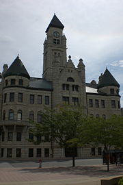
The Wichita-Sedgwick County Historical Museum[2] in downtown Wichita occupies the original Wichita city hall, built in 1892. The museum contains artifacts that tell the story of Wichita and Sedgwick County starting from 1865 and continuing to the present day.
Slightly east of downtown, Old Town was transformed in the early 1990s from an old warehouse district to a mixed-zone neighborhood with residential space, nightclubs, restaurants, hotels and museums, including the Great Plains Transportation Museum and Museum of World Treasures.
The Ulrich Museum of Art and Lowell D. Holmes Museum of Anthropology are part of Wichita State University.
The Wichita River Festival is held each May in the Downtown and Old Town areas of the city. It is one of the longest continuous running festivals in the state of Kansas and features over 70 events, including musical entertainment, sporting events, traveling exhibits, cultural and historical activities, plays, interactive children's events, a flea market, river events, a parade, block parties, a food court, fireworks and souvenirs for the roughly 370,000+ patrons who attend each year.[16]
The River Run, a 10K race held on the first Saturday of the festival, is the largest road race in Kansas.
Media
The Wichita Eagle began circulation in 1872 and remains the major daily newspaper in Wichita. There is also a weekly business newspaper, the The Wichita Business Journal.
Monthly publications include Wichita Magazine, The Urban News and The Chronicle.
See Broadcast Media in Wichita for the full list of local terrestrial television stations.
Cable television service for Wichita and the surrounding areas is provided by Cox Communications and AT&T.
Sports
Sports teams in Wichita are:
- Wichita Wingnuts, Baseball
- Wichita Thunder, Ice Hockey
- Wichita Wild, Indoor Football
- Wichita Barbarians, Rugby Union
- Wichita Wombats, Pro Ballhockey League
- Wichita World 11, Cricket
Disc golf is a popular activity in Wichita. There are two eighteen hole disc golf courses (with alternate pads): Oak Park in the Riverside Area and Herman Hill Park at Pawnee and Broadway. Other courses in the metro area are listed at the Kansas Disc Golf site.
History

The site on the two rivers has served as a trading center for nomadic peoples for the last 11,000 years. The area was visited by Francisco Vásquez de Coronado in 1541, while he was in search of the fabulous "cities of gold." While there, he encountered a group of Indians whom he called Quiviras and who have been identified by archeological and historical studies as Wichita Indians. By 1719 these people had moved south to Oklahoma, where they met French traders. The first permanent settlement in Wichita was a collection of grass houses inhabited by the Wichita Indians in 1863. They had moved back to Wichita from Oklahoma during the American Civil War due to their pro-Union sentiments. The city was officially incorporated in 1870. Shortly thereafter it became a railhead destination for cattle drives from Texas and other south-western points, from whence it has derived its nickname of "Cowtown." It quickly gained a wild reputation, and had numerous well known lawmen pass through, employed to help keep the rowdy cowboys in line. Among those lawmen was Wyatt Earp.
Wichita reached national fame in 1900 when Woman's Christian Temperance Union (WCTU) member Carrie Nation decided to carry her crusade against alcohol to Wichita. On December 27 of that year she entered the Carey House bar in downtown Wichita and smashed the place with a rock and a pool ball. She had visited all the bars in Wichita the night before and demanded that they close their doors. However, the painting by John Noble of Cleopatra at the Roman Bath in the Carey House had drawn her particular wrath.
In 1914-1915, oil was discovered nearby and Wichita became a major oil center. The money derived from oil allowed local entrepreneurs to invest in a nascent airplane industry. In 1917, the first plane, the Cessna Comet, was manufactured in Wichita. Forty-three Swallows, the first airplanes made specifically for production, were built in Wichita between 1920 and 1923. This industry, coinciding with Wichita becoming a test center for new aviation, established Wichita as the "Air Capital." Lloyd Stearman and Walter Beech were employees of the Swallow Aircraft Company, but in January 1925 they left Swallow Aircraft and teamed up with Clyde Cessna to form Travel Air. Lloyd Stearman left the company in 1926 to start Stearman Aircraft in Venice, California. Cessna quit in January 1927 to start Cessna. Stearman would only be gone from Wichita for a year before returning.
Travel Air, with Walter Beech at the helm, grew to over 600 employees and operated from a huge factory complex constructed from 1927 to 1929. Due to employing so many workers at such a large complex and being a few miles outside the city limits, it was tagged "Travel Air City" by Wichita residents. The company merged with the huge Curtis Wright Corporation in the Roaring Twenties' heyday of company buyouts and takeovers just two months before the Stock Market crash in 1929. Workers were laid off by the hundreds during 1930 and more so in 1931. By the fall of 1932 all workers of Travel Air in Wichita were let go, the equipment was sold and the entire Travel Air plant sat empty.
In March 1932 Walter quit Curtis Wright to form Beech Aircraft with his wife Olive Ann and hired Ted Wells as his chief engineer. The first four or five "Beechcraft" were built in the vacant Cessna Aircraft plant which was also closed during the depression. Beech later leased and then bought the Travel Air plant from Curtis Wright and men, machinery, and an airplane or two were moved from the Cessna plant. The first aircraft was the Model 17, later dubbed the "Staggerwing", which was first flown on November 5, 1932. The aircraft that would propel the small company into a huge corporation was the Model 18 "Twin Beech", of which thousands were built from 1937 to 1969. The Staggerwing production ended in 1946 with approximately 750 built, and a few more were assembled from parts in 1947. The Staggerwing production was replaced by the Beechcraft Bonanza, although there are still nearly 100 Staggerwings in existence, most in usable condition.
In October of 1932 orchestra leader Gage Brewer introduced the electric guitar to the world from Wichita using an instrument developed by what would later become known as the Rickenbacker Guitar Company.
The city experienced a population explosion during World War II when it became a major manufacturing center for airplanes needed in the war effort. By 1945, 4.2 bombers were being produced daily in Wichita. Stearman Aircraft, later purchased by the Boeing Company, was founded in Wichita, as were Beech Aircraft (now called Hawker Beechcraft), Cessna Aircraft, and LearJet (now Bombardier). The city remains a major manufacturing center for the aircraft industry today, with all of these and Airbus still having major centers there, hence its nickname: "The Air Capital."
Wichita was also a significant entrepreneurial business center during the pre and post-war period, with Coleman, Mentholatum, Pizza Hut, Spangles, White Castle, Taco Tico and Koch Industries having all been founded in Wichita. (Ironically, White Castle closed all of their restaurants in Wichita in 1938 and has not operated in the state of Kansas after a failed revival attempt in the Kansas City area in the early 1990s.) The entrepreneurial spirit of Wichita led to the creation one of the first academic centers to study and support entrepreneurship at The Wichita State University Center for Entrepreneurship.
Recent history has seen increased development in downtown and to the east and west sides of Wichita. Sedgwick County voters recently approved a sales tax raise to build a new arena downtown to replace the aging Kansas Coliseum. This is considered by some as a stepping stone to launch new development downtown.
Sister cities
 Cancún, Mexico - 25 November 1975
 Kaifeng, China - 3 December 1985
 Orléans, France - 16 August 1944 through Sister Cities International
- Tlalnepantla, Mexico - 16 October 1973
 Evanston, Illinois - 17 September 1984
Metro cities
|
|
Education
The majority of Wichita's students are served by Wichita Public Schools (USD 259), although portions of Wichita are served by the Derby (USD 260), Haysville (USD 261), Maize (USD 266), Valley Center (USD 262), Goddard (USD 265) and Circle (USD 375) school districts. The largest private schools are Bishop Carroll Catholic High School, The Independent School, Kapaun Mt. Carmel High School and Wichita Collegiate School.
Colleges and universities
- Baker University
- Bethel College (in North Newton Kansas)
- Butler Community College (formerly Butler County Community College)
- Cowley County Community College
- Friends University
- Newman University
- Southwestern College - (in Winfield, Kansas)
- Tabor College
- University of Kansas School of Medicine - Wichita
- University of Phoenix-Wichita Campus
- Wichita Area Technical College
- Wichita State University
- Wichita Technical Institute
- Webster University
See also
- List of people from Wichita, Kansas
Information on this and other cities in Kansas
- List of cities in Kansas
- Kansas locations by per capita income
Other information for Kansas
- List of counties in Kansas
- List of unified school districts in Kansas
- List of colleges and universities in Kansas
References
- ↑ 1.0 1.1 1.2 "American FactFinder". United States Census Bureau. Retrieved on 2008-01-31.
- ↑ "US Board on Geographic Names". United States Geological Survey (2007-10-25). Retrieved on 2008-01-31.
- ↑ "Table 1: Annual Estimates of the Population for Incorporated Places Over 100,000, Ranked by July 1, 2007 Population: April 1, 2000 to July 1, 2007" (CSV). 2007 Population Estimates. United States Census Bureau, Population Division (2008-07-10). Retrieved on 2008-07-10.
- ↑ http://www.sedgwickcounty.org/arena/
- ↑ "Best Places to Live 2006". Money Magazine (2006). Retrieved on 2008-08-05.
- ↑ "2008 MSN Real Estate best bargain markets". MSN Real Estate (2008). Retrieved on 2008-08-26.
- ↑ "Population Estimates". U.S. Census Bureau, Population Division. Annual estimates of the population to 2006-07-01. Released 2007-06-28. Population change is from 2000-07-01 to 2006-07-01.
- ↑ City of Wichita - Transit Services Main
- ↑ Kansas Asks Amtrak to Study Additional Passenger Rail Service - amtrak.com
- ↑ Westside route notes
- ↑ Westside route map and timetable
- ↑ City of Wichita - Park and Recreation Parks, Greenways, and Recreation Corridors
- ↑ City of Wichita - Historic Preservation Main
- ↑ http://wichitaartmuseum.org/visitorInfo.html
- ↑ http://www.wichitalinks.com/attractions.html
- ↑ River Festival estimates record attendance - Wichita Business Journal:
External links
- Official City of Wichita Web Site
- Wichita Metro Chamber of Commerce
- Greater Wichita Convention & Visitors Bureau
- Wichita Mid-Continent Airport
- The Wichita Eagle (local daily newspaper)
- Local Historic Neighborhood Newspaper
- 360Wichita.com (directory of local business and entertainment)
- Wichita Attractions, Events, Travel and Lodging
Additional information
- City of Wichita-History, on city-administered web page.
- History of the Wichita Beat poets and artists.
- LASR: Wichita Kansas Attractions, Events and Recreation.
- [3] Website of the Bradley Fair Mall
- Wichita Photo Archives
- [4] Website of the Wichita-Sedgwick County Historical Museum
|
||||||||||||||||||||
|
|
|||||