Western Visayas
 |
|
| Regional center | Iloilo City |
|---|---|
| Population | 6,211,038 [1] |
| – Density | 342.6 per km² |
| Area | 20,440.8 km² |
| Divisions | |
| – Provinces | 6 |
| – Cities | 16 |
| – Municipalities | 117 |
| – Barangays | 4,050 |
| – Cong. districts | 16 |
| Languages | Hiligaynon, Kinaray-a, Aklanon, others |
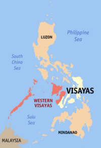
Western Visayas, one of the regions of the Philippines, is designated as Region VI. It consists of six provinces; Aklan, Antique, Negros Occidental, Capiz, Guimaras and Iloilo and 17 cities making it the region with the highest number of cities. Iloilo City is the regional center.
Contents |
Composition
Western Visayas is composed of six provinces and the highly urbanized cities of Bacolod and Iloilo with Kalibo as the sole international gateway (Kalibo Airport serves direct flights to Incheon-Korea, and Taipei, with Shanghai, Beijing, Hong Kong and Singapore next) .
The province of Aklan occupies the northwestern coastal plain of the island of Panay. Its 1,853 km² supports a population of 441,000 in seventeen municipalities, of which Kalibo is the capital. After strenuous and sustained political efforts, Aklan was separated from Capiz by act of the national legislature in April 1956. Agriculture is a prominent part of the economy, principal products being rice, maize, coconuts, and cut flowers. Ocean- fishing is also important, as is tourism, Boracay, an internationally known, world-class white-sand island-resort just offshore. Kalibo is known also for the mother of Philippine Festivals Ati-Atihan held every third week of January, the Bakhawan Eco-park (Philippines' most successful mangrove reforestation project), and Piñacloth weaving. Inland fishing and aquaculture yield several export products. This actually seems to explain every element in the shield. Meat-processing and paper-related cottage industries are widespread, and rattan furniture is manufactured for export.
The province of Antique, on the western side of Panay Island, is separated from the other provinces by a long range of mountains. One of these, Mt. Madia-as, is the highest mountain on the island, a dormant volcano adorned with several lakes and more than a dozen waterfalls. The population is largely Austronesian; according to legend, they were immigrants from Borneo centuries before the Spanish arrived. The main language in Antique is Kinaray-a, but several Visayan languages are also spoken. The area was made a separate province by the Spanish government in 1790. Its name seems to be a Spanish adaptation of a local word. The province's area is 2,522 km², its population 456,000, no cities, eighteen towns, of which San José de Buenavista is the capital. Agriculture is important; sugar and coconuts lead, with coconut oil and coconut wine both being significant. Ocean fishing is also important; one website speaks of "the tuna highway along the coast." Seaweed is harvested. Marble and gemstones are mined. Other valuable mineral deposits are known but undisturbed. Like Capiz, it seems to have enormous potential for tourism, its many miles of sandy beaches being sparsely settled. There are also hot springs in the mountains.
The people of Negros Occidental speak mostly Ilonggo, a Visayan language of the Central Philippine group; Cebuano, another Central Philippine language, is a distant second. Most also speak English. In the second half of the nineteenth century sugar cane cultivation grew enormously, drawing many settlers from other islands. Negros Occidental was made a separate province in 1890. In spite of three periods of warfare, sugar remained dominant long into the twentieth century, as the province came to produce most of the country's total sugar production. In the late 1970s the world price of sugar fell sharply, and continued into the early 1980s, and in 1983 the province suffered a serious drought, and, in 1984, two typhoons. An attempt in 1986 to separate the northern part as the province of Negros del Norte was defeated. Meanwhile, starting in 1985, the province received considerable help from the national government and foreign donors to recover economically, which included economic diversification. Today the province has substantial production of coffee, cacao, black pepper, fruits, and grains. It also has a large copper mine. Gold, silver, molybdenum, iron, gypsum, coal, and other minerals are mined. Light industry is growing. Should one wish to visit and disburse, there are excellent opportunities for aquatic recreations, including underwater photography. Mount Kanlaon, the highest peak on the island, is a bird sanctuary, home to a hundred species known nowhere else in the world. The sugar industry led to the building of steam railroads, now nicknamed "iron dinosaurs." Some are still roar and race and breathe fire; others, abandoned, moulder away. The population of Negros Occidental is 2,556,000 in thirteen cities and nineteen towns. In addition to the capital city of Bacolod, Negros Occidental has twelve component cities, making it the province with the most number of cities.

| Province/City | Capital | Population (2000) |
Area (km²) |
Pop. density (per km²) |
|---|---|---|---|---|
| Aklan | Kalibo | 451,314 | 1,817.9 | 248.3 |
| Antique | San Jose | 471,088 | 2,522.0 | 186.8 |
| Capiz | Roxas City | 654,156 | 2,633.2 | 248.4 |
| Guimaras | Jordan | 141,450 | 604.7 | 233.9 |
| Iloilo | Iloilo City | 1,925,002 | 4,719.4 | 407.9 |
| Negros Occidental | Bacolod City | 2,565,723 | 7,926.1 | 323.7 |
| Bacolod City¹ | — | 429,076 | 161.5 | 2,657.6 |
| Iloilo City¹ | — | 365,820 | 56.0 | 6,533.0 |
¹ Bacolod City and Iloilo City are highly urbanized cities; figures are excluded from Negros Occidental and Iloilo respectively.
Component cities
- Bago City, Negros Occidental
- Cadiz City, Negros Occidental
- Escalante City, Negros Occidental
- Himamaylan City, Negros Occidental
- Kabankalan City, Negros Occidental
- La Carlota City, Negros Occidental
- Passi City, Iloilo
- Roxas City, Capiz
- Sagay City, Negros Occidental
- San Carlos City, Negros Occidental
- Silay City, Negros Occidental
- Sipalay City, Negros Occidental
- Talisay City, Negros Occidental
- Victorias City, Negros Occidental
History
The Western Visayas region was created from Aklan, Antique, Capiz, Iloilo (including its then-subprovince of Guimaras) and Negros Occidental by Presidential Decree No. 1 as part of the Integrated Reorganisation Plan of President Ferdinand Marcos.
The Province of Palawan was transferred to Region VI (Western Visayas) on May 23, 2005 by Executive Order 429.[2] The Department of the Interior and Local Government announced in June of 2005 that the transfer had been completed.[3] However, Palaweños criticized the move, citing a lack of consultation, with most residents in Puerto Princesa City and all municipalities but one preferring to stay with Region IV-B. Consequently, Administrative Order No. 129 was issued on August 19, 2005 to address this backlash. This Order directed the abeyance of Executive Order 429 pending the approval of an implementation plan for the orderly transfer of Palawan from Region IV-B to Region VI.[4] Hence, Palawan is currently (as of May, 2007) still part of Region IV-B.
Languages
The languages native to the inhabitants of Western Visayas are:
- Hiligaynon, spoken in Iloilo, Negros Occidental, Guimaras, and Capiz (where it is known as Capiznon). It is the lingua franca of the region.
- Kinaray-a, spoken in Antique and parts of Iloilo.
- Aklanon, spoken in Aklan.
- Malaynon, spoken in Aklan.
- Cebuano, spoken in the eastern parts of Negros Occidental.
References
- ↑ Western Visayas May 2000 census report
- ↑ President of the Philippines. "Executive order No. 429". Office of the Press Secretary.
- ↑ Government of the Philippines - News (3 June, 2005). "Palawan, Puerto Princesa Transfer to Region VI". Press release.
- ↑ President of the Philippines (August 19, 2005). "Administrative Order No. 129". Office of the Press Secretary.
External links
|
|||||||||||