Wertheim am Main
| Wertheim | |
 |
|
| Coat of arms | Location |
 |
 |
| Administration | |
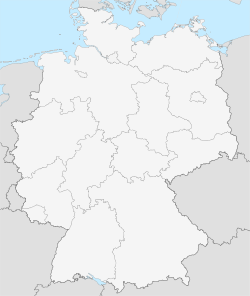
| Country | Germany |
|---|---|
| State | Baden-Württemberg |
| Admin. region | Stuttgart |
| District | Main-Tauber-Kreis |
| Town subdivisions | Kernstadt, 15 Ortschaften and 5 Stadtteile |
| Lord Mayor | Stefan Mikulicz (CDU) |
| Basic statistics | |
| Area | 138.63 km² (53.5 sq mi) |
| Elevation | 145 m (476 ft) |
| Population | 24,302 (30/12/2006) |
| - Density | 175 /km² (454 /sq mi) |
| Other information | |
| Time zone | CET/CEST (UTC+1/+2) |
| Licence plate | TBB |
| Postal code | 97877 |
| Area code | 09342 |
| Website | www.wertheim.de |
Wertheim is a town in southwestern Germany, in the state of Baden-Württemberg with a population of 24,452. It is located on the confluence of the rivers Tauber and Main.
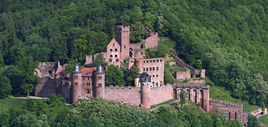
It is known for its wine, castle and medieval town centre.
Contents |
Geography
Wertheim is the most northerly town in the state of Baden-Württemberg. It is situated on the delta of the river Tauber flowing into the river Main. It borders on the Odenwald and the Spessart to the north across the river Main.
Neighboring parishes
The following Cities and parishes border on Wertheim, listed clockwise starting at the east:
Holzkirchen, Helmstadt and Neubrunn (all district Würzburg, Bavaria), Werbach and Külsheim (both district Main-Tauber-Kreis), Neunkirchen (district Miltenberg, Bavaria), Freudenberg (Main-Tauber-Kreis), Stadtprozelten and Faulbach (both district Miltenberg) and Hasloch, Kreuzwertheim and Triefenstein (all district Main-Spessart, Bavaria).
History

Wertheim was founded between the 7th and 8th century, however the first settlement was a town called Kreutzwertheim on the right of the river Main. From the early 12th century onwards, a branch of the noble family of the Reginbodons called themselves after the town. After the family of the earls of Wertheim had built a castle on the left bank of the river Main, a settlement developed at the foot of this dominating structure that was called Wertheim. It was mentioned for the first time in 779. In 1192, it was referred to as "Suburbium castri Wertheim" and in 1200 the town is called “oppidium” and 1244 “civitas”.
The town Wertheim developed into the center of the county of Wertheim. The county existed until 1806 when it was divided as a consequence of the Reichsdeputationshauptschluss ("Principal Conclusion of the Extraordinary Imperial Delegation"). The area left of the Main river was given to the Grand Duchy of Baden, while the territories right of the Main, were given to the Kingdom of Bavaria.
In 1938 Wertheim was merged with Tauberbischofsheim into the new Landkreis Tauberbischofsheim. From 1972 onwards 15 communities were incorporated with Wertheim. The 15 communities are Bettingen, Dertingen, Dietenhan, Dörlesberg, Grünenwört, Höhefeld, Kembach, Lindelbach, Mondfeld, Nassig, Reicholzheim, Sachsenhausen, Sonderriet, Urphar and Waldenhausen. As of January 1 1973 the Landkreis Tauberbischofsheim was merged into the new Main-Tauber-Kreis. Due to the incorporation of surrounding communities, Wertheim reached the 20,000 population mark in 1975. Wertheim became a Große Kreisstadt (district town) on January 1 1976.
Established in 1406, the cemetery of the former Jewish community is one of the oldest in Germany. In use up until the 20th century, it is the oldest existing Jewish cemetery in Baden-Württemberg.
Coat of arms
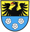
The coat of arms of Wertheim, shows a parted shield the upper part in gold with a black eagle and below in blue three silver roses. The city flag is yellow-blue. The coat of arms is nearly unchanged in use since 1556. It is the coat of arms of the earls of Wertheim, which resided in the Wertheim castle and which controlled a small area for centuries.The meaning of the symbols is unknown.
Sights

Buildings
The Burg Wertheim (castle) is the landmark of the town. Wertheim has a medieval town center with half-timbered houses and small streets. The Protestant church (Stifskirche) has existed in Gothic style architecture since 1383. Two clocks can be seen on the clock tower, one with an hour hand only, for the residents of the castle. The Kilianskapelle is one of the finest examples of gothic-style chapels in Germany and was under construction from 1469 onwards. The Engelsbrunnen (Angels' well) from 1574 was built of the red sandstone typical of this area and derives its name from the two little angels which hold Wertheim’s coat of arms. Noteworthy also is the Kittsteintor with the flood markings from 1595 onwards and the Blaue Haus (Blue house) with the only known paint that uses blue glass fragments for the color.
A visit to the abbey Bronnbach founded in 1150 in the Tauber valley, is also recommended. Consecrated in 1222, the Basilica in the late-Romanesque and early-Gothic style is one of the most important churches of a religious order in south Germany.
Wertheim has restored iss lovely 1799 synagogue.[1]
Museums
- Glasmuseum (glass museum)
- Grafschaftsmuseum
Twin Cities
 - Salon-de-Provence (France), since 1964
 - Huntingdon and Godmanchester (United Kingdom), since 1981
 - Szentendre (Hungary), since 1989
- - Csobánka (Hungary), since 1992
 - Gubbio (Italy), since 2006
Population
|
|
¹ Census result
Mayor (Bürgermeister) and Lord Mayor (Oberbürgermeister)
- 1810-1827: Johann Christoph Schlundt
- 1827-1829: Christoph Michael Platz
- 1829-1832: Johann Georg Weimar
- 1832-1839: Johann Friedrich Bach
- 1839-1840: Christoph Wilhelm Müller
- 1840-1845: Johann Jakob von Runkel
- 1845-1852: Ludwig Haas
- 1852-1860: Johann Jakob von Runkel
- 1860-1866: Ludwig Haas
- 1866-1871: Philipp Frank
- 1871-1880: Lorenz Meyer
- 1880-1890: Philipp Amthauer
- 1890-1895: Philipp Mayer
- 1895-1905: Michael Müller
- 1905-1933: Hans Bardon
- 1933-1938: Friedrich Bender
- 1938-1943: Hans Mensler
- 1944-1945: Hermann Dürr
- 1945: Carl Roth
- 1945-1946: Michael Beck
- 1946: Otto Hoog
- 1946-1961: Carl Roth
- 1961-1981: Karl Josef Scheuermann
- 1981-2003: Stefan Gläser
- 2003-today: Stefan Mikulicz
Events
Summer festival (Altstadtfest) on the last three days of July, followed by a medieval festival at the castle followed by the Wertheimer Messe (like Oktoberfest).
Trivia
For many years Wertheim was home to Peden Barracks, a US Army installation. Headquartered at Peden Barracks was the 72nd Field Artillery Brigade, as well as two Field Artillery Battalions - 3/35FA (8 inch self-propelled) and 4/27 FA (MLRS). Also the 71 Assault helicopter company that flew the UH-1H "Huey" or Iroquois helicopter. The US Army left Peden Barracks in the early 1990s as part of the post Cold War reorganization of US armed forces in Germany.
External links
- Official website (German)
- Tourist site {[de icon}}
- Photos of Wertheim and Peden Barracks (1999)
- Peden Barracks blog
References
|
||||||||||||||||
|
|||||||