Wayne County, Michigan
| Wayne County, Michigan | |
| Map | |
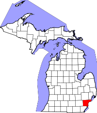 Location in the state of Michigan |
|
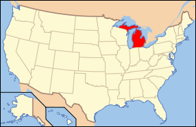 Michigan's location in the U.S. |
|
| Statistics | |
| Founded | August 15, 1796 [1] |
|---|---|
| Seat | Detroit |
| Area - Total - Land - Water |
672 sq mi (1,741 km²) 614 sq mi (1,591 km²) 58 sq mi (150 km²), 8.64% |
| Population - (2000) - Density |
2,061,162 3,356/sq mi (1,296/km²) |
| Website: www.waynecounty.com | |
Wayne County is a county in the U.S. state of Michigan. As of the 2000 census, the population was 2,061,162 with an estimated population of 1,985,101 as of July 1, 2007, making it the 13th most populous county in the United States. The county seat is Detroit[1], the largest city in Michigan.
Contents |
Geography
According to the U.S. Census Bureau, the county has a total area of 672 square miles (1,741 km²)—614 square miles (1,591 km²) of it is land and 58 square miles (150 km²) of it (8.64%) is water (including parts of the Detroit River and Lake St. Clair).
Wayne County borders on Oakland County and Macomb County to the north, Washtenaw County to the west, and Monroe County to the south.
The eastern (and sometimes southern) boundary is a water boundary in the Detroit River and Lake St. Clair with Essex County, Ontario, Canada. Automotive traffic crosses this boundary at the Detroit-Windsor Tunnel and the Ambassador Bridge. Due to the change in direction of the river, this portion of Ontario actually lies south of Wayne County. Due to the direction ambiguity, the southern communities of the county are usually referred to as "Downriver".
Grosse Ile is the largest island in Wayne County and is connected to the mainland by the Wayne County Bridge.
Adjacent counties
- Washtenaw County (west)
- Monroe County (south)
- Macomb County (northeast)
- Oakland County (northwest)
- Essex County, Ontario (east, southeast)
National protected area
- Detroit River International Wildlife Refuge (part)
Major roads
|
|
I-75 |
|
|
I-94 |
|
|
I-96 |
|
|
I-275 |
|
|
I-375 |
|
|
US-12 |
|
|
US-24 |
|
|
M-1 |
|
|
M-3 |
|
|
M-5 |
|
|
M-8 |
|
|
M-10 |
|
|
M-14 |
|
|
M-39 |
|
|
M-53 |
|
|
M-85 |
|
|
M-97 |
|
|
M-102 |
|
|
M-153 |
Demographics
| Historical populations | |||
|---|---|---|---|
| Census | Pop. | %± | |
| 1900 | 348,793 |
|
|
| 1910 | 531,591 | 52.4% | |
| 1920 | 1,177,645 | 121.5% | |
| 1930 | 1,888,946 | 60.4% | |
| 1940 | 2,015,623 | 6.7% | |
| 1950 | 2,435,235 | 20.8% | |
| 1960 | 2,666,297 | 9.5% | |
| 1970 | 2,666,751 | 0% | |
| 1980 | 2,337,891 | −12.3% | |
| 1990 | 2,111,687 | −9.7% | |
| 2000 | 2,061,162 | −2.4% | |
| Est. 2007 | 1,985,101 | −3.7% | |
As of the census[2] of 2000, there were 2,061,162 people, 768,440 households, and 511,781 families residing in the county. The population density was 3,356 people per square mile (1,296/km²). There were 826,145 housing units at an average density of 1,345 per square mile (519/km²). The racial makeup of the county was 51.70% White, 42.16% Black or African American, 0.37% Native American, 1.70% Asian, 0.02% Pacific Islander, 1.55% from other races, and 2.49% from two or more races. 3.75% of the population were Hispanic or Latino of any race. 8.5% were of German, 8.0% Polish and 5.7% Irish ancestry according to Census 2000. 89.3% spoke English, 3.2% Spanish and 2.4% Arabic as their first language.
Three native American grouping had over 1000 people in Wayne County in 2000. I use the vague term because one is the 1,015 Iroquois, including at least in theory members of all six tribes, although since the census does not report the numbers from specific tribes not all tribes may be represented. Chippewa or Ojibwa numbered 2,041. The Cherokee were the most numerous group of Native Americans here in Wayne County, as in most of the United States, with 4,127.[3]
There were eight groups of Asians who were identified as having over 1000 in Wayne County. Asian Indians numbered 15,856. Chinese came in second at 5879. After that comes the Filipinos, numbering 5480. There were 2478 Koreans. Bangladeshis numbered 2238. Next came Japanese numbering 2025. Hmongs numbered 1927. Pakistanis numbered 1887 and Vietnamese 1684.[3]
There were 768,440 households out of which 32.80% had children under the age of 18 living with them, 40.70% were married couples living together, 20.60% had a female householder with no husband present, and 33.40% were non-families. 28.30% of all households were made up of individuals and 10.00% had someone living alone who was 65 years of age or older. The average household size was 2.64 and the average family size was 3.26.
In the county the population was spread out with 28.00% under the age of 18, 8.70% from 18 to 24, 30.30% from 25 to 44, 20.90% from 45 to 64, and 12.10% who were 65 years of age or older. The median age was 34 years. For every 100 females there were 92.20 males. For every 100 females age 18 and over, there were 88.10 males.
The median income for a household in the county was $40,776, and the median income for a family was $48,805. Males had a median income of $42,392 versus $29,027 for females. The per capita income for the county was $20,058. About 12.70% of families and 16.40% of the population were below the poverty line, including 23.00% of those under age 18 and 11.30% of those age 65 or over.
Largely fueled by the decline in Detroit's population, the Wayne County population fell below 2,000,000 in 2004 or 2005. By 2006 its population was estimated at 1,971,853. Despite continued growth in the far west part of the county, Detroit, and the Down-river and Livonia-Westland-Dearborn region suburbs continued to see population declines.
In 2005 estimates the white population had climbed back to over 53%, with the two or more races reported population falling bellow 2%. The Hispanic population had climbed to 4.6% of the county total. Another factor was the huge exodus of African Americans to Macomb and Oakland counties, however the African American percentage in the total county figures held steady at 42%. The percentage of non-Hispanic whites in Wayne County, fell to 49.7 from 49.9 from 2000-2005. The percentage of Asians rose, largely fueled by growth in the Indian population in such places as Canton. This was despite the huge exodus of Hmongs from north-east Detroit to Warren.
Government


Wayne County is Michigan's only "charter county", with a home rule charter setting up its structures within limits set in state law and constitution. All other Michigan county governments are structured according to state law, without a locally adopted charter.
The county government operates the jail, maintains rural roads, keeps files of deeds and mortgages, maintains vital records for all areas except Detroit, administers public health regulations, and participates with the state in the provision of welfare and other social services. Most other local government functions – police and fire, building and zoning, tax assessment, street maintenance, etc. – are the responsibility of individual cities and townships.
Wayne County Elected officials
- County Executive: Robert A. Ficano (Democrat)
- Prosecuting Attorney: Kym L. Worthy (Democrat)
- Sheriff: Warren C. Evans (Democrat)
- County Clerk: Cathy M. Garrett (Democrat)
- County Treasurer: Raymond J. Wojtowicz (Democrat)
- Register of Deeds: Bernard J. Youngblood (Democrat)
- County Board of Commissioners: Jewel C. Ware, Chairwoman (Democrat) 15 members, elected from districts (14 Democrats, 1 Republican)
- Circuit Court (3rd Circuit encompasses Wayne County): 66 judges (non-partisan)
- Probate Court: 8 judges (non-partisan)
(information as of February 2006)
Politics
| Year | Democrat | Republican |
|---|---|---|
| 2004 | 69.39% 600,047 | 29.81% 257,750 |
| 2000 | 69.01% 530,414 | 29.02% 223,021 |
| 1996 | 68.95% 504,466 | 24.04% 175,886 |
| 1992 | 60.39% 508,464 | 26.96% 227,002 |
| 1988 | 60.18% 450,222 | 39.03% 291,996 |
| 1984 | 57.19% 496,632 | 42.31% 367,391 |
| 1980 | 58.60% 522,024 | 35.42% 315,532 |
| 1976 | 60.11% 548,767 | 38.18% 348,588 |
| 1972 | 53.26% 514,913 | 45.08% 435,877 |
| 1968 | 63.25% 654,157 | 26.16% 270,566 |
| 1964 | 75.97% 831,674 | 23.83% 260,901 |
| 1960 | 65.99% 773,327 | 33.66% 394,485 |
History

Wayne County was one of the first counties formed when the Northwest Territory was organized. It was named for the American general "Mad Anthony" Wayne. It originally encompassed the entire area of the Lower Peninsula of Michigan, as well as small sections that are now part of northern Ohio, Indiana and Illinois. By proclamation of the Territorial Secretary and Acting Governor, Winthrop Sargent, on August 15, 1796, the boundaries of Wayne County were declared to begin at the mouth of the Cuyahoga River then west to Fort Wayne, then to the southernmost point of Lake Michigan and along the western shore north to the territorial boundary in Lake Superior and then along the territorial boundary through Lake Huron, Lake St. Clair, and Lake Erie back to the starting point. [4]
On January 14, 1803, the Governor of Indiana Territory, William Henry Harrison, issued a similar proclamation defining the boundaries as beginning at a point where an east and west line passing through the southernmost extreme of Lake Michigan would intersect a north and south line, passing through the westernmost extreme of the lake, then north to the territorial boundary, then along said boundary line to a point where an east and west line passing through the southerly extreme of Lake Michigan would intersect the same, then along this last mentioned line to the place of beginning. This boundary would include Chicago, Illinois and a sizable strip of Wisconsin along Lake Michigan. [5]
These boundaries would be adjusted as Indiana and Illinois became states and as other counties were formed within Michigan Territory.
Cities, villages, and townships

Cities
|
|
|
Villages
- Grosse Pointe Shores (most, with the remainder in Macomb County; residents voted to incorporate as a city in 2008)
Townships
|
|
Notable residents
Mickey "Sneaky Pee" Goodwin, Former Middleweight and Light Heavyweight Boxing Contender
References
- ↑ "Find a County". National Association of Counties. Retrieved on 2008-01-31.
- ↑ "American FactFinder". United States Census Bureau. Retrieved on 2008-01-31.
- ↑ 3.0 3.1 Detailed Tables - American FactFinder
- ↑ "Proclamation by Winthrop Sargent". Collections of the Pioneer Society of the State of Michigan together with Reports of County Pioneer Societies, Vol VIII. (second edition ed.). Lansing, Mich.: Wynkoop Hallenbeck Crawford. 1907. pp. pp. 496-497. http://memory.loc.gov/cgi-bin/ampage?collId=lhbum&fileName=5298a/lhbum5298a.db&recNum=511&itemLink=r?ammem/lhbum:@field(DOCID+@lit(lhbum5298adiv236))%235298a0512&linkText=1. Retrieved on 2006-10-15.
- ↑ "Proclamation by Governor Harrison". Collections of the Pioneer Society of the State of Michigan together with Reports of County Pioneer Societies, Vol VIII. (second edition ed.). Lansing, Mich.: Wynkoop Hallenbeck Crawford. 1907. pp. pp. 540-542. http://memory.loc.gov/cgi-bin/ampage?collId=lhbum&fileName=5298a/lhbum5298a.db&recNum=555&itemLink=r%3Fammem%2Flhbum%3A%40field%28DOCID%2B%40lit%28lhbum5298adiv3%29%29%235298a0009&linkText=1. Retrieved on 2006-10-15.
External links
- Wayne County Government
- Wayne County Local History
- Clarke Historical Library, Central Michigan University, Bibliography on Wayne County
|
|||||||||||||||||||||||
|
|||||||||||||||||||||||||||||||||||
|