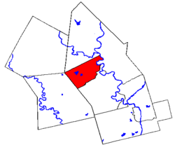
Waterloo, Ontario
| City of Waterloo | |
 |
|
| Motto: Stability | |
 |
|
| Coordinates: | |
| Country | Canada |
|---|---|
| Province | Ontario |
| Regional Municipality | Waterloo Region |
| Established | May 27, 1857 |
| Government | |
| - City Mayor | Brenda Halloran |
| - Governing Body | Waterloo City Council |
| - City CAO | Simon Farbrother |
| - MP | Peter Braid (Conservative) |
| - MPP | Elizabeth Witmer (PC) |
| Area | |
| - Total | 64.1 km² (24.7 sq mi) |
| Elevation | 329 m (1,079 ft) |
| Population (2006)[1] | |
| - Total | 97,475 |
| - Density | 1,520.7/km² (3,938.6/sq mi) |
| Time zone | Eastern (EST) (UTC−5) |
| - Summer (DST) | EDT (UTC−4) |
| Postal codes | N2J, N2K, N2L, N2T, N2V |
| -Population was 113,100 in 2005 with students
(source) |
|
| Website: City of Waterloo | |
Waterloo is a city in Ontario, Canada. It is the smallest of the three cities in the Regional Municipality of Waterloo, and is adjacent to the larger city of Kitchener.
Kitchener and Waterloo are often jointly referred to as Kitchener-Waterloo (K-W), or "the twin cities", although they have separate city governments. There have been several attempts to amalgamate the two cities (sometimes with the city of Cambridge as well), but none have been successful.
The reported population for the city can vary depending on how temporary residents at Waterloo's two universities are counted. At the time of the 2006 census, Waterloo had a population of 97,475.[1] That number does not include post-secondary students who are temporary residents. The city's total population at the end of 2006—with over 20,000 non-resident post-secondary students included—was 114,700.[2]
The Intelligent Community Forum named Waterloo the Top Intelligent Community of 2007.[3] Waterloo had lost to Taipei in 2006.
Contents |
History
Waterloo was built on land that was part of a parcel of 675,000 acres (2,730 km²) assigned in 1784 to the Iroquois alliance that made up the League of Six Nations. Almost immediately—and with much controversy—the native groups began to sell some of the land. Between 1796 and 1798, 93,000 acres (380 km²) were sold through a Crown Grant to Richard Beasley, with the Six Nations Indians continuing to hold the mortgage on the lands.
The first wave of immigrants to the area were Mennonites from Pennsylvania.[4] They bought deeds to land parcels from Beasley and began moving into the area in 1804. The following year, a group of 26 Mennonites pooled resources to purchase all of the unsold land from Beasley and discharge the mortgage held by the Six Nations Indians.
The Mennonites divided the land into smaller lots; two lots initially owned by Abraham Erb became the central core of Waterloo. Erb is often called the founder of Waterloo, as it was his sawmill (1808) and grist mill (1816) that became the focal point of the area.[5]
In 1816, the new township was named after Waterloo, Belgium, the site of the Battle of Waterloo, which had ended the Napoleonic Wars in Europe. After that war, the area became a popular destination for German immigrants. By the 1840s, German settlers had overtaken the Mennonites as the dominant segment of the population. Many Germans settled in the small hamlet to the southeast of Waterloo. In their honour, the village was named Berlin in 1833 (renamed to Kitchener in 1916). Berlin was chosen as the site of the seat for the County of Waterloo in 1853.
Waterloo was incorporated as a village in 1857 and became the Town of Waterloo in 1876 and the City of Waterloo in 1948.
Government

Waterloo city council consists of seven councillors, each representing a ward, and a mayor. The number of wards expanded from five to seven in the November 2006 elections. The current mayor of Waterloo is Brenda Halloran, who was elected in November 2006.
The City is responsible for fire protection, libraries, parks and recreation, and secondary streets. Many municipal services are provided through the Regional Municipality of Waterloo (often referred to as Waterloo Region or the Region of Waterloo), which consists of the cities of Waterloo, Kitchener, and Cambridge, and the townships of Woolwich, Wilmot, Wellesley, and North Dumfries. Regional responsibilities include social welfare, community health, and policing through the Waterloo Regional Police Service.
Past and present city councils have been committed to providing for the explosive population growth that is coming with the local economic boom. Rapidly developing subdivisions are often described by their critics as urban sprawl that threatens environmentally sensitive areas and valuable agricultural land.
Federally and provincially, the entire city of Waterloo is contained within the Kitchener-Waterloo electoral district.
Geography

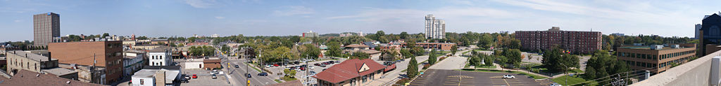
Waterloo's city centre is located near the intersection of King and Erb streets. Since 1961, the centrepiece has been the Waterloo Town Square shopping centre, which underwent a thorough renovation in 2006. Much of the mall was torn down and has been replaced by buildings that emphasize street-facing storefronts.
Residents refer to the Waterloo city centre as "uptown" (often capitalized), while "downtown" is reserved for the Kitchener city centre.
Historically, the city centre was once along Albert Street, near the Marsland Centre and the Waterloo Public Library. The town hall, fire hall, and farmers' market were located there. Amidst some controversy, all were demolished between 1965 and 1969.
There are five main parks in the city. RIM Park occupies 2 square kilometres (500 acres) and is home to a variety of indoor and outdoor sporting facilities, including an eighteen-hole golf course, and the heritage Martin Farm House. Waterloo Park is in Uptown Waterloo, and contains historical buildings, a bandshell, animal displays, and the Lions' Lagoon water park in its 45 hectares (111 acres). The park is also known for its light displays during the Christmas holiday season, known as "Wonders of Winter" [1]. Bechtel Park occupies 44 hectares (109 acres) and has many outdoor sporting facilities along with wetlands, meadows and hardwood forest. The park also includes an off-leash dog park, and adjacent city-operated cemetery. Hillside Park covers 25 hectares (62 acres) and includes two lighted ball diamonds. Lexington Park includes a ball diamond and a soccer pitch on the former site of the K-W Municipal Airport. The 3 square kilometre (725 acre) Laurel Creek Conservation Area lies in the northwest of the city.
The Grand River flows southward along the east side of the city. In the west end of the city, the Waterloo Moraine provides over 300,000 people in the region with drinking water. Much of the gently hilly Waterloo Moraine underlies existing developed areas. Ongoing urban growth, mostly in the form of low-density residential suburbs (in accordance with requests by land developers), will cover increasing amounts of the remaining undeveloped portions of the Waterloo Moraine.
Economy

Waterloo has a service-oriented economy with flourishing insurance and high-tech sectors as well as two major universities.[6] The city's largest employers are Sun Life Financial/Clarica, the University of Waterloo, Manulife Financial, Research In Motion, and Wilfrid Laurier University.
The city is part of Canada's Technology Triangle (CTT), a joint economic development initiative of Waterloo, Kitchener, Cambridge and the Region of Waterloo that markets the region internationally. Despite its name, CTT does not focus exclusively on promoting technology industries, but on all aspects of economic development.
Waterloo has a strong technology sector with hundreds of high-tech firms.[6] The dominant technology company in the city is Research In Motion, makers of the BlackBerry, which has its headquarters in the city and owns several office buildings near the University of Waterloo's main campus.
Notable Waterloo-based high-tech companies include:

- Dalsa
- Descartes Systems Group
- Maplesoft
- MKS Inc.
- Open Text Corporation
- Research In Motion (RIM)
- Sandvine
Many other high-tech companies, with headquarters elsewhere, take advantage of the concentration of high-tech employees in the Waterloo area, and have research and development centres there. Sybase, Google, Oracle, Adobe, McAfee, NCR Corporation and Agfa are among the large, international technology companies with development offices in Waterloo.
Before it became known for technology, Waterloo was often called "the Hartford of Canada" because of the many insurance companies based in the area.[4] Manulife, Sun Life Financial and Economical Insurance have a significant presence in the city.
Breweries and distilleries had been a significant industry in the Waterloo area until 1993 when a Labatt-owned brewery was shut down. Now the only major brewery is the Brick Brewing Company. Waterloo was the original home of distiller Seagram (also home town of many descendants of J.P. Seagram), which closed its Waterloo plant in 1992. Of the remaining Seagram buildings, one became home of the Centre for International Governance Innovation (CIGI), while others were converted into condominiums.
Transport
Roads
The Conestoga Parkway and Highway 8 connect Waterloo with Kitchener, Cambridge, Highway 7/8, and Highway 401.
Waterloo shares several of its north-south arterial roads with neighbouring Kitchener. They include (from east to west) Bridge Street, Weber Street, King Street, Westmount Road, and Fischer-Hallman Road. Regina Street (located between Weber and King Streets) and Albert Street (located between King Street and Westmount Road) are north-south roads located entirely within Waterloo.
The city's east-west thoroughfares are almost entirely located within city limits, with the exception of Union Street, which has a small sections in Kitchener. Waterloo's major east-west arterial roads are (from south to north) Union Street, Erb Street, Bridgeport Road, University Avenue, Columbia Street, and Northfield Drive.
Public transport
- See also: Rapid transit in Waterloo Region
Public transport throughout Waterloo Region is provided by Grand River Transit, created by a merger of Kitchener Transit (which served Waterloo) and Cambridge Transit in January 2000. GRT operates a number of bus routes in Waterloo, with many running into Kitchener. In September 2005 an express bus route called iXpress was added that runs from downtown Cambridge through Kitchener to Conestoga Mall in North Waterloo. Regional council has supported the construction of a light rail system to connect Waterloo, Kitchener, and Cambridge. As of 2007, a study is underway to recommend a form of rapid transit, with rapid buses and light rail transit under consideration.
Railways
Waterloo no longer has any regularly scheduled passenger rail service. VIA Rail trains between Sarnia and Toronto stop at the nearby Kitchener railway station southeast of uptown Waterloo at the corner of Victoria Street and Weber Street. The station is accessible by local buses via Kitchener's downtown Charles Street transport centre.
There are no GO Transit railway stations within reasonable distance of Waterloo. The nearest is Milton station. City councillors and public petitions have called for the extension of GO trains to the Region of Waterloo, but at present GO does not plan to go beyond already-announced bus links.
In May 2007, city council gave approval for a non-profit tourist train to run between the train station on Father David Bauer Drive to the St. Jacobs Market District, reviving the route of the Waterloo-St. Jacobs Railway from the late 1990s. The train is scheduled to run on a limited schedule from June to December 2007.[7]
Air
The closest airport to Waterloo is the Region of Waterloo International Airport in nearby Breslau, but while it is a thriving general-aviation field, it is not heavily served by scheduled airlines. Northwest Airlines offers flights to Detroit, Michigan, and on May 14, 2007, WestJet began offering one daily non-stop flight to Calgary, Alberta through to October. As of October 1, 2007, Bearskin Airlines offers daily round trip service to Ottawa, Ontario.[8] Most air travellers use either Toronto Pearson International Airport or John C. Munro Hamilton International Airport. There are no permanent public transport links from Waterloo to any of these airports.
Demographics
Many locals are of ethnic German descent. There is also a strong Mennonite presence. The universities and colleges attract a large number of individuals from elsewhere in Canada and the world.
Race
From the 2001 census data, excluding post-secondary students temporarily residing in Waterloo:[9]
- White: 74,460 or 86.6%

- South Asian: 3,695 or 4.3%
- Chinese: 2,970 or 3.4%
- Black: 1,395 or 1.6%
- Filipino: 1,060 or 1.09%
- Hispanics: 630 or 0.7%
- Other: 2,910 or 3.3%
Religion
From the 2001 census data, excluding post-secondary students temporarily residing in Waterloo:[9]
- Protestant: 37,090 or 43.1%
- Catholic: 23,975 or 27.8%
- No Affiliation: 15,100 or 17.5%
- Other Christian: 3,875 or 4.5%
- Muslim: 2,425 or 2.8%
- Hindu: 1,385 or 1.6%
- Sikh: 785 or 0.9%
- Buddhist: 595 or 0.7%
- Jewish: 410 or 0.5%
- Other: 435 or 0.5%
Tourism
Waterloo is home to several tourist attractions and areas of interest. These include:
- Canadian Clay and Glass Gallery
- Centre for International Governance Innovation
- Conestoga Mall
- Earth Sciences Museum
- Elliott Avedon Museum & Archive of Games
- Erbsville Kartway
- Esson Estates Winery Co-op
- KidZone Family Fun Center
- Laurel Creek Conservation Area
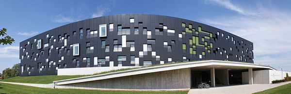
- Perimeter Institute for Theoretical Physics
- RIM Park
- The Shops at Waterloo Town Square
- The Waterloo Entertainment Centre
- Waterloo Memorial Recreation Complex
- Waterloo Park
- Waterloo-St. Jacobs Railway
- Westhill Meadows Golf Course
Other nearby attractions include:
- African Lion Safari
- Bingemans
- Centre In The Square
- Doon Heritage Crossroads
- St. Jacobs
- Joseph Schneider Haus
- Stratford Festival of Canada
- Waterloo Regional Children's Museum
- Wings Of Paradise
- Woodside National Historic Site
Events & festivals
- Ice Dogs Festival - February
- GO! Music Festival - March
- Waterloo County & Area Quilt Festival - May
- Uptown Country Festival - June
- Canada Day Fireworks, Columbia Lake Fields - July 1
- Uptown Waterloo Jazz Festival - July
- Waterloo Busker Carnival - August
- CAFKA: International Biennale of Contemporary Art - September
- Royal Medieval Faire - September
- Oktoberfest Parade - October
- Kitchener-Waterloo Oktoberfest: the largest Oktoberfest celebration outside of Germany - October
- Santa Claus Parade - November
- World Religions Conference : the largest multi-faith event of its kind in Canada featuring the world's major religions - October-November
- Waterloo Festival for Animated Cinema - November
- Wonders Of Winter (festival of lights) - December
- Cinematheque Waterloo - Year round
Education
Secondary
Until the 1960s, with a few minor exceptions, Waterloo students would attend high school in Berlin/Kitchener. In 1914, Waterloo Lutheran Seminary added a high school department, named the College School, primarily to provide secondary education for prospective seminary students. The College School was discontinued in 1929. Between 1940 and 1950, due to overcrowding in Kitchener-Waterloo Collegiate and Vocational School, some grade nine classes were housed in Elizabeth Ziegler Public School.
Starting in the 1960s, several high schools opened in Waterloo. In 1958 it was announced that Waterloo would have its own secondary school. A $1,247,268 school was built on a 20 acre (81,000 m²) site on Hazel Street. Waterloo Collegiate Institute opened on September 6, 1960. In 1968, Laurel Vocational School (later University Heights Secondary School) opened, and in 1972 Waterloo's third public high school, Bluevale Collegiate Institute, opened. In 1965, St. David Senior School, which served grades 7-10, opened in the north of the city. St. David was turned into a high school in 1985 and was renamed St. David Catholic Secondary School. University Heights Secondary School closed in 2004 and Sir John A. Macdonald Secondary School opened that same year.
As of 2007, there are four high schools based in Waterloo. Three are operated by the Waterloo Region District School Board: Bluevale Collegiate Institute (east), Sir John A. Macdonald Secondary School (west), and Waterloo Collegiate Institute (central), and one by the Waterloo Catholic District School Board: St. David Catholic Secondary School.
Post-secondary
The main campuses of the University of Waterloo and Wilfrid Laurier University are located in Waterloo. Kitchener-based Conestoga College also has a Waterloo campus, located at the former University Heights Secondary School on University Avenue near Weber Street. Conestoga purchased the building in January 2006 for nearly $6 million from the Waterloo Region District School Board. It is double the size of its previous Waterloo campus on King Street, which was sold after the University Heights building was acquired.
There is evidence that Waterloo residents harbour adversarial attitudes towards Waterloo post-secondary students.[10]. One of the local newspapers consistently portrays students as second class citizens, yard animals, and hooligans. Although some residents (both students and non-students) have expressed disapproval over these inflammatory editorials, the tension between residents and students none-the-less persists in other student related media coverage[11]. The attitude, however, may be caused by the frequent, loud and well-publicized instances of vandalism, hooliganism, noise and raucous behaviour sometimes displayed by some of the city's post-secondary crowd.
Health care
The hospitals serving Waterloo are all located in Kitchener. There is Grand River Hospital, which includes the K-W and Freeport health centres (formerly independent hospitals that amalgamated in April 1995), and St. Mary's General Hospital.
Media
Location from Waterloo
| Destinations from WATERLOO | |||||||||||
| Wellesley | St. Jacobs, Elmira via Conestoga Parkway |
Conestogo, West Montrose via Northfield Dr |
|||||||||
| Wilmot, St. Agatha |
|
Woolwich, Guelph | |||||||||
| Stratford via Conestoga Parkway |
Kitchener via King St |
||||||||||

Waterloo neighbourhoods
| Districts within WATERLOO | |||||||||||
| Beechwood, Laurelwood, Columbia Forest, Upper Beechwood | Lakeshore North, Lakeshore, Conservation Meadows, Erbsville |
Eastbridge, Colonial Acres, Lincoln Village, Lexington, Country Squire Estates | |||||||||
| Clair Hills, Beechwood West, Maple Hills, Westvale |
|
Lincoln Heights, University Downs, Kiwanis Park Estates | |||||||||
| Westmount | |||||||||||
References
- ↑ 1.0 1.1 "2006 Community Profiles". Statistics Canada. Retrieved on 2007-08-08.
- ↑ "Population and Households in the Region of Waterloo". Region of Waterloo. Retrieved on 2007-08-08.
- ↑ "Intelligent Community Awards 2007". Intelligent Community Forum. Retrieved on 2007-08-08.
- ↑ 4.0 4.1 "Our Proud History". City of Waterloo. Retrieved on 2007-08-30.
- ↑ "Erb-Kumpf House, 172 King Street South, Designated: February 19, 1979". City of Waterloo. Retrieved on 2007-08-30.
- ↑ 6.0 6.1 "Riding profile". Canadian Broadcasting Corporation. Retrieved on 2007-08-30.
- ↑ "Tourist train arrives in summer," Tamsin McMahon, The Record, May 29, 2007.
- ↑ News - seat sales, promotions and company news - Bearskin Airlines
- ↑ 9.0 9.1 "All Data". Statistics Canada. Retrieved on 2007-08-08.
- ↑ Waterloo Chronicle editorial http://www.waterloochronicle.ca/search?OrderBy=sPublishDate%20desc&r=category:%22Waterloo%20Chronicle%22&q=editorials
- ↑ Waterloo Chronicle, http://www.waterloochronicle.ca/news/ghetto/article/124428
External links
General
Education
Events & festivals
- Kitchener-Waterloo Oktoberfest
- Uptown Waterloo Jazz Festival
- Waterloo Busker Carnival
- Royal Medieval Faire
- Wonders Of Winter
- Ice Dogs Festival
- Canada Day at Columbia Lake
- Uptown Country Festival
- World Religions Conference
Business & technology
|
||||||||||||||