Vinson Massif
| Vinson Massif | |
|---|---|
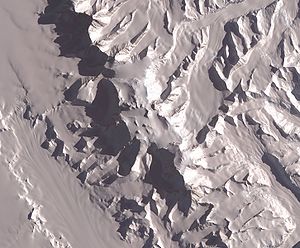 NASA image of Vinson Massif from space |
|
 Vinson Massif
|
|
| Elevation | 4,892 metres (16,050 ft) |
| Location | Antarctica |
| Range | Sentinel Range |
| Prominence | 4,892 m Ranked 8th |
| Coordinates | |
| First ascent | 1966 by Nicholas Clinch and party |
| Easiest route | snow/ice climb |
| Listing | Seven summits, Ultra |
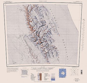
Vinson Massif is the highest mountain of Antarctica, located about 1,200 km (750 mi) from the South Pole. The mountain is about 21 km (13 mi) long and 13 km (8 mi) wide.[1] At 4,892 metres (16,050 ft) the highest point is Mount Vinson, which was named in 2006 by US-ACAN.[2] The southern end of the massif is capped by Mount Craddock (4,368 m) although the highest point on the south side is Mount Rutford (4477 m).
The massif lies in the Sentinel Range of the Ellsworth Mountains, which stand above the Ronne Ice Shelf near the base of the Antarctic Peninsula.
The massif's existence was unsuspected until January 1958, when it was spotted by US Navy aircraft from Byrd Station. It was named after Carl Vinson (also the namesake of an aircraft carrier), a United States Georgia Congressman who was a key supporter of funding for Antarctic research.[1]
Contents |
Measurement
The first measurement of the Vinson Massif was established in 1959 at the elevation of 5,140 m (16,864 ft).[1] In the 1979-80 climbing season, a U.S. party consisting of two Germans and a Soviet climber, reached the top and placed a red flag and ski pole which assisted ground parties in establishing a more accurate height of 4,897 m (16,066 ft).[3]
In January 2001, a team sponsored by NOVA made the first ascent of the east face and after running GPS on the summit for 20 minutes, established a new height of 16,077 ft (4,900.3 m).[4]
The current height (4,892 m) resulted from a GPS survey by the 2004 Omega Foundation team comprising Damien Gildea of Australia (leader), and Rodrigo Fica and Camilo Rada of Chile.[5] Since 1998 and continuing through 2007, the Omega Foundation has placed a GPS receiver on the summit for a suitable period of time to obtain accurate satellite readings.[6]
First ascent
The summit was first reached in December 1966 by a group of climbers from the USA.
In 1963, two groups within the American Alpine Club, one led by Charles Hollister and Samuel C. Silverstein, M.D., then in New York, and the other led by Peter Schoening of Seattle, Washington, began lobbying the National Science Foundation to support an expedition to climb Vinson. The two groups merged in spring 1966 at the urging of the National Science Foundation and the American Alpine Club, and Nicholas Clinch (Pasadena, CA) was recruited by the American Alpine Club to lead the merged expeditions. Named officially the American Antarctic Mountaineering Expedition 1966/67, the expedition was sponsored by the American Alpine Club and the National Geographic Society, and supported in the field by the U.S. Navy and the National Science Foundation Office of Antarctic Programs. Ten scientists and mountaineers participated in AAME 1966/67. In addition to Clinch they were Barry Corbet (Jackson Hole, WY), John Evans (University of Minnesota, Minneapolis, MN), Eiichi Fukushima (University of Washington, Seattle, WA), Charles Hollister, Ph.D. (Columbia University, New York, NY), William Long, Ph.D. (Alaska Methodist University, Anchorage, AK), Brian Marts (Seattle, WA), Peter Schoening (Seattle, WA), Samuel Silverstein, M.D. (Rockefeller University, New York, NY) and Richard Wahlstrom (Seattle, WA).
In the months prior to its departure for Antarctica the expedition received considerable press attention, primarily because of the reports that Woodrow Wilson Sayre was planning to fly in a Piper Apache piloted by Max Conrad, the "flying Grandfather", with four companions into the Sentinel Range to climb the Vinson Massif. Sayre had a reputation for problematic trips as a result of his unauthorized, unsuccessful, and nearly fatal attempt to climb Mt. Everest from the North in 1962. His unauthorized incursion into Tibet led China to file an official protest with the U.S. State Department. In the event, the purported race did not materialize. Conrad had difficulties with his plane. According to press reports, he and Sayre were still in Buenos Aires on the day the first four members of AAME 1966/67 reached Vinson's summit.
In December 1966 the Navy transported the expedition and its supplies from Christchurch, New Zealand to the U.S. base at McMurdo Sound, Antarctica, and from there in a ski-equipped C-130 Hercules to the Sentinel Range. All members of the expedition reached the summit of the Vinson Massif. The first group of four climbers summited on December 18, 1966, four more on December 19, and the last three on December 20.
On August 18, 2006, from nomination by Damien Gildea of the Omega Foundation, US-ACAN approved naming the subsidiary peaks south of Mt. Vinson for the AAME 1966/67 members Nicholas Clinch, Barry Corbet, Eiichi Fukushima, Charles Hollister, Brian Marts, Samuel Silverstein, Peter Schoening and Richard Wahlstrom. Other peaks in the Sentinel Range had previously been named for John Evans and William Long.[7]
Later ascents
The climb of Vinson offers little technical difficulty beyond the usual hazards of travel in Antarctica, and as one of the Seven Summits, it has received much attention from well-funded climbers in recent years. Between 1985 and 2000 Adventure Network International, the only private guide to Vinson Massif, brought over 450 climbers to the summit. Several companies now guide clients up Vinson Massif.
First ascent from East Face
While the vast majority of prior climbs to the summit have used the western side of the massif from the Branscomb Glacier, the first ascent from the east side was successfully completed by an eight-person team sponsored by NOVA in January 2001.[4] The team consisted of:
- Conrad Anker - expedition leader
- Jon Krakauer - mountaineer and author
- Dave Hahn - mountain guide with 19 ascents from the established route
- Andrew Mclean - extreme skier
- Dan Stone - glaciologist
- Lisel Clark - producer (who also became the first woman to make an ascent from this side)
- John Armstrong - cameraman
- Rob Raker - assistant cameraman and sound recording
The team not only made the first ascent from the east side but also performed scientific research into snow accumulation at different elevations as well as taking the first ground based GPS reading from the summit. The GPS reading gave the elevation of the highest point in Antarctica as 16,077 ft (4,900 m), eclipsing the earlier established heights recorded in 1959 and 1979.
Another first was the successful aircraft landing of a Twin Otter on the Upper Dater Glacier on the eastern slopes of Vinson Massif.
NOVA named the production "Mountain of Ice", which first aired on PBS in February 2003.[4]
Notes
References
- NOVA. "Mountain of Ice". WGBH. Retrieved on 2004-12-28.
- 7 Summits. "GPS waypoints for the Vinson Massif". Retrieved on 2007-01-29.
- 7 Summits (2008). "Mount Vinson, the summit of Antarctica". Retrieved on 2008-09-20.
- Gildea, Damien; Splettstoesser, John (2007-08-27), Craddock Massif and Vinson Massif remeasured, 10th International Symposium on Antarctic Earth Sciences (ISAES), 2007, http://isaes.confex.com/isaes/2007/techprogram/P1166.HTM, retrieved on 2008-09-20
- ExplorersWeb Inc.. "Vinson Massif & The Sentinel Range: New map - new names". The Poles. Retrieved on 2008-09-20.
- USGS GNIS. "Vinson Massif". Retrieved on 2008-09-20.
- USGS GNIS. "Mount Vinson". Retrieved on 2008-09-20.
- U.S. Geological Survey and The National Academies (2007), USGS OF-2007-1047, Short Research Paper 069, doi:10.3133/of2007-1047.srp069, http://pubs.usgs.gov/of/2007/1047/srp/srp069/of2007-1047srp069.pdf, retrieved on 2008-09-20
|
|||||