Veracruz
| State of Veracruz Estado Libre y Soberano de Veracruz de Ignacio de la Llave |
|||
| — State — | |||
|
|||
| Nickname(s): Veracruz | |||
| Motto: "Veracruz late con fuerza"[1] | |||
 |
|||
| Country | |||
|---|---|---|---|
| Capital | Xalapa | ||
| Municipalities | 212 | ||
| Largest City | Veracruz | ||
| Government | |||
| - Governor | Fidel Herrera Beltrán (PRI) | ||
| - Federal Deputies | PRI: 6 PAN: 11 PRD: 2 Convergencia: 2 |
||
| - Federal Senators | PRD: 1 PAN: 1 Convergencia: 1 |
||
| Area Ranked 11th |
|||
| - Total | 71,699 km² (27,683.1 sq mi) | ||
| Population (2005) | |||
| - Total | 7,110,214 (Ranked 3rd) | ||
| Time zone | CST (UTC-6) | ||
| - Summer (DST) | CDT (UTC-5) | ||
| HDI (2004) | 0.7457 - medium Ranked 28th |
||
| ISO 3166-2 | MX-VER | ||
| Postal abbr. | Ver. | ||

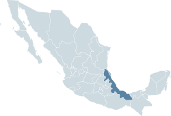
Veracruz, formally Veracruz de Ignacio de la Llave is one of the 31 states that constitute the republic of Mexico.
Contents |
Location
It is located in the east-central part of the Gulf of Mexico country, between 17°10 and 22°38 North and between 93°55' and 98°38' West. It has a mainland area of and includes several islands in the Gulf of Mexico totalling a further 58 square kilometers (22.4 sq mi).
Veracruz borders the states of Tamaulipas to the north, Oaxaca and Chiapas to the south, Tabasco to the southeast, Puebla, Hidalgo, and San Luis Potosí to the west, and the Gulf of Mexico to the east.
On the coastal plains and throughout most of the state, the climate is hot and humid. On the foothills of the mountains, the climate is cool and humid. The climate only becomes cold in the mountain regions, where it also rains copiously. Veracruz is occasionally affected by hurricanes from November through October.
This state has a tropical climate and impressive natural scenery, such as the Citlaltépetl Volcano (also known as Pico de Orizaba), the highest peak in the nation. You’ll also see picturesque cities and towns that have preserved their local architecture. Along the coast you can visit the Costa Esmeralda, a 50 kilometers (31 mi) beach strip north of the port, and the archaeological zone of El Tajin, which also was declared a UNESCO World Heritage Site.
Its capital is Xalapa, located in the central western part of the state. With more than 7 million inhabitants, the state of Veracruz is the third most populous in the nation, after the Federal District and the State of Mexico.
History
In April 1518, Juan de Grijalva disembarked on an islet near the shore that was called San Juan de Ulúa. On April 22, 1519 Hernan Cortez disembarked on Chalchihuecan beach, where he decided to found a village and form the first colonial settlement in Mexico. That day was Good Friday, the day of Holy Week known as the day of La Vera Cruz (True Cross) — hence he chose the name of La Villa Rica de la Vera Cruz.
It was from this base in August 1519 that Cortez began his course of conquest inland to Tenochtitlan, Mexico, while his subsidiary conquistador commanders pacified other regions that today shape the entity of Veracruz.
From this beginning, Veracruz as the entry point for conquest, became the principal point of communication and harbor between Spain and New Spain. From this port were shipped many products to Europe like cotton, rice, wheat, domestic animals, gun powder, textiles, wine and all the considerable produce from this rich colony and particular territory.
Vegetation
The State of Veracruz, produces and exports:
- Sugar Cane
- Banana
- Pitaya
- Mango
- Guava
- Melons
- Watermelons
- Guanabana
- Lemons
- Lime
- Oranges
- Mandarin orange
- Plums
- Jicama
- Coffee
- Vanilla
- Avocado
- Cucumber
- Jalapeño pepper
- Coconut
Tourism
In pre-Hispanic era, Isla de Sacrificios (Sacrifice Island), was inhabited by the Totonacs and the Olmecs, and was named Chalchihuitlapazco. It was discovered in 1518 by Juan de Grijalva, during the exploration of the Gulf of Mexico. One of the largest islands around Boca del Río, this site is surrounded by a coral reef.
La Antigua was the second settlement after "La Villa Rica de la Veracruz". It is located 25 kilometers from Veracruz City. It features the house of Hernán Cortés. It is a small town that holds the oldest still-standing Catholic chapel built in the American continent.
Papantla was founded by Totonacs. It is located 198 meters above sea level between the Cazones and Tecolutla rivers.[2]
El Tajín (City of Thunder) the main ceremonial center of the Totonacs, is located near 3 miles from Papantla, a beautiful and impressive antique city, ruins and traditions are founded there.
Languages
Spanish is the official and heavily dominant language in Veracruz. Nahuatl is still spoken and common use in some towns and zones like Zongolica, Papantla, Mixtequilla and Huayacocotla. There are minor areas of Italian speakers near Huatusco and Tuxtlas, where Venetto is common use and there are a very few Greek speakers in towns near Rinconada, the "gitanos" (Gypsy). As well on the region of the low San Rafael, the French is predominant, due to the settle of the remaining Maximilian of Hapsburg troops that were allowed to stay, after they were defeated, on the fall of the second empire in the XIX century. Also needs to be mentioned: Catalan, Basque, Gaelic, and more Spaniard dialects that were brought and kept by their descendants. Although some people know essentials of English, mainly in commerces or touristic zones of big cities, locals never use it to communicate.
Traditionally, the (Spanish) accent of Veracruz resembles Caribbean Spanish, with strong tendency to drop syllable final -S/-Z as in the Cuban accent.
Examples:
- máh o menoh for más o menos
- conohco for conozco
- bahta for basta
- Veracru for Veracruz
etc.
Yet under the influence of the capital, this feature has weakened among the younger generation.
Municipalities
The state of Veracruz is subdivided into 212 municipalities (municipios). See municipalities of Veracruz.
The municipalities are grouped into the following regions (regiones):
- Capital
- Huasteca Alta
- Huasteca Baja
- Montañas
- Nautla
- Olmeca
- Papaloapan
- Sotavento
- Totonaca
- Tuxtlas
Major communities
- Acayucan
- Actópan
- Boca del Rio
- Camarón de Tejeda
- Catemaco
- Coatepec
- Coatzacoalcos
- Córdoba
- Martínez de la Torre
- Minatitlán
- Orizaba
- Papantla (Papantla de Olarte)
- Poza Rica (Poza Rica de Hidalgo)
- San Andrés Tuxtla
- Tuxpan (Túxpam/Túxpam de Rodríguez Cano)
- Veracruz
- Xalapa (Xalapa-Enríquez)
Climate
| for Veracruz | |||||||||||||||||||||||||||||||||||||||||||||||
|---|---|---|---|---|---|---|---|---|---|---|---|---|---|---|---|---|---|---|---|---|---|---|---|---|---|---|---|---|---|---|---|---|---|---|---|---|---|---|---|---|---|---|---|---|---|---|---|
| J | F | M | A | M | J | J | A | S | O | N | D | ||||||||||||||||||||||||||||||||||||
|
43
26
19
|
18
28
19
|
17
30
21
|
19
32
23
|
48
33
25
|
263
32
25
|
347
32
24
|
359
32
24
|
436
32
24
|
183
30
23
|
96
29
22
|
67
27
20
|
||||||||||||||||||||||||||||||||||||
| temperatures in °C precipitation totals in mm source: [1] |
|||||||||||||||||||||||||||||||||||||||||||||||
|
Imperial conversion
|
|||||||||||||||||||||||||||||||||||||||||||||||
References
- ↑ (Spanish) Veracruz State government This is the motto used by the current State administration
- ↑ Turismo Veracruz
External links
- (Spanish) Veracruz State government
- (Spanish) museum of the city
|
||||||||||