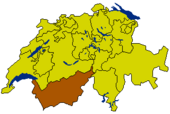
Valais
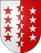
| Canton du Valais Kanton Wallis |
|||
|
|||
| Capital | Sion | ||
| Population (2007) | 298,580 (Ranked 9th) | ||
| - Density | 56 /km² | ||
| Area | 5224 km² (Ranked 3rd) | ||
| Highest point | 4634 m - Dufourspitze | ||
| Lowest point | 372 m - Lake Geneva | ||
| Joined | 1815 | ||
| Abbreviation | VS | ||
| Languages | French, German | ||
| Executive | Conseil d'Etat, Staatsrat (5) | ||
| Legislative | Grand Conseil, Grosser Rat (130) | ||
| Municipalities | 160 municipalities | ||
| Districts | 13 districts, Bezirke | ||
| Website | www.VS.ch | ||
 |
|||
The Valais (German: Wallis) is one of the 26 cantons of Switzerland in the southwestern part of the country, around the valley of the Rhône from its headwaters to Lake Geneva, separating the Pennine Alps from the Bernese Alps. The canton is one of the drier parts of Switzerland in its central Rhône valley. Paradoxically it is also one of most well-watered parts, having large amounts of snow and rain up on the highest peaks found in Switzerland. The canton of Valais is probably best known for the Matterhorn and ski resorts such as Zermatt or Verbier.
Contents |
Geography

The canton of Valais lies in the southwest of Switzerland. To its south lies Italy, to the southwest France. To the north the canton is bounded by the Swiss cantons of Vaud and Bern; the cantons of Uri and Ticino lie to its east.
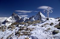
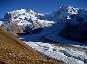
The wide, glacial Rhône valley dominates the area. There are many side valleys which branch off the main valley. These vary from narrow and remote to reasonably populous and popular. At the head of the Mattertal valley lies Zermatt, a pretty tourist village dominated by views of the Matterhorn (4 478 m). Fifty of the mountains exceed 4 000 m with the highest, Monte Rosa, reaching to 4 638 m (15,217ft), and there are numerous glaciers from among which the largest in the Alps.
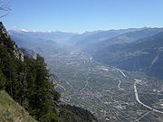
The Rhône drains the main valley from east to west up to Martigny, then in a right angle north to its mouth in the Lake Geneva. After the small town of Saint-Maurice, the northern banks of the river belong to the canton of Vaud. The main valley is bound by the Bernese Alps in the north and the Pennine Alps in the south. Other ranges situated partially in Valais are the Chablais Alps, the Mont Blanc Massif, the Urner Alps and the Lepontine Alps. Only about half of the total area is considered productive.
Valleys
- Further information: Valleys of the Alps
- North of the Rhône
- Fieschertal
- Lötschental
- Dalatal (Leukerbad)
- South of the Rhône:
- Binntal
- Manztal
- Saastal
- Mattertal
- Turtmanntal
- Val d'Anniviers
- Val d'Hérens
- Val d'Hérémence
- Val de Vendaz
- Val de Bagnes
- Val d'Entremont
- Val Ferret
- Val d'Illiez
History

The Romans called the area Vallis Poenina ("Upper Rhône Valley"). From 888 onwards the lands were part of the kingdom of Jurane Burgundy.
King Rudolph III of Burgundy gave the lands to the Bishop of Sion in 999, making him Count of the Valais. The count-bishops then struggled to defend their area against the dukes of Savoy, so that the medieval history of the Valais is inextricably linked with that of the diocese of Sion.
The Valais resisted the Protestant Reformation, remaining faithful to the Roman Catholic Church. On March 12, 1529, Valais became an associate member (Zugewandter Ort) of the Swiss Confederation. In 1628 the Valais became technically a republic, the République des Sept Dizains / Republik der Sieben Zehenden under the guidance of the prince-bishop of Sion and the bailli. The bishop remained in power until 1798 when Napoleon's troops invaded the Valais and declared a Revolutionary République du Valais (March 16) which was swiftly incorporated (May 1) into the Helvetic Republic until 1802 when it became the independent Rhodanic Republic. In 1810 the Rhodanic Republic was annexed by Napoleonic France as the département of Simplon. Independence was restored in 1813 and on August 4, 1815 the Valais finally entered the Swiss confederation as a canton. In 1845 the Valais joined the Catholic separatist league (Sonderbund), but chose not to fight the troops of the confederation in 1847 and submitted to the federal forces.
Economy
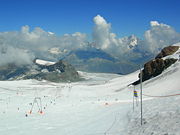

Wine production and tourism are some of the main industries of the canton. The Matterhorn near Zermatt is one of the biggest tourist attractions in the Swiss mountains, as is its sister valley immediately east Saas Fee. Other parts of the mountains of the canton further west are popular as well, such as the more French-speaking resorts near Verbier and the Evolene and Arolla region. The resorts on the north side of the main Rhône river valley are popular, looking out southwards towards the Peninne Alps and still part of the southern slope of the Bernese Alps, such as the family-oriented resort of Crans-Montana. The resorts in the Goms region are slightly less known, yet also receive attention during the summer hiking season and the winter ski season.
Apart from tourism, agriculture is still important, particularly cattle breeding in the mountains and dairy farming in the plains. The wine industry of the canton is the largest in Switzerland. There are also a large number orchards in the area, and saffron is also gathered here.
Europe's tallest gravity dam is located at Grande Dixence in the canton. Hydroelectric power plants from the canton produce about a quarter of Swiss electricity.
The west part and the most industrial region of the canton is called Chablais. The area is very important for the economy. The lands from the Valais part of Lake Geneva to the town of St-Maurice are located in the Chablais. There are a lot of factories, the most important are the subsidiaries of Novartis and Syngenta, in Monthey. In the town of Collombey-Muraz, there is an oil refinery.
Near Visp there is a large aluminium processing plant. Other metal products and chemicals are produced around Visp and Sierre.
Despite the thriving tourist industry, high level of infrastructure, and the many vineyards, canton Valais is still one of the poorest of the Swiss cantons, and not yet near the wealthier banking/financial cantons. A large portion of the canton's land and houses is now owned by foreigners.
The mountainous canton with a plethora of ski resorts was narrowly passed over in the bid for the 2002 Winter Olympics and 2006 Winter Olympics.
Transport
A small airport is located at Sion, but the main routes of transport are rail and road. Both networks are extensive and benefit from tourism. There are two major rail tunnels at the Simplon (Simplon Tunnel) and Lötschberg (Lötschberg Tunnel) and a road tunnel at the Great St Bernard. Many of the road passes are well known, such as the Grimsel Pass. The longest land tunnel in the world, the Lötschberg Base Tunnel, is in operation since late 2007, connecting by rail the town of Frutigen in canton Bern, with the town of Visp in canton Valais/Wallis. This is to better allay car traffic in the highly scenic Kandertal, and also to provide faster transport through the Bernese Alps from the populous Mittelland in the north to the southern canton of Valais. Cars may be loaded onto the trains as freight. The old train line will still likely have traffic though, as it has highly scenic sections in both cantons on either side of the old tunnel through the dividing ridgeline, yet is somewhat slower than the new route which has a much longer tunnel section.
Because of the tourism there are many mountain railways and cable cars in the mountains. The scenic rail route across the Furka Pass originates in the canton of Valais.
Demographics


Valais is predominantly French- and Arpitan-speaking. The eastern part of the canton Upper Valais, however, speaks Walliser German. The French-speaking population makes up a little bit more than two thirds of the total population.
The whole canton is thinly populated. The population of the canton is 298,580 of which 57,061 (or 19.1%) are foreigners[1]. The largest towns are the capital Sion (Sitten), Monthey, Sierre, Martigny and Brig. There is no major city located in the canton. Over 90% of the population is Roman Catholic.
Towns and villages
- Anzère
- Bluche
- Brig
- Sion
- Sierre
- Monthey
- Martigny
- Crans-Montana
- Leukerbad
- Saas-Fee
- Verbier
- Visp
- Zermatt
Municipalities
The following are the municipalities of the canton, by district.
Brig
Conthey
Entremont
Goms
Hérens
|
Leuk
Martigny
Monthey
West Raron
|
East Raron
Saint-Maurice
Sierre
Sion
Visp
|
See also
- Swiss Alps
- Le Nouvelliste, daily
- Sion, Switzerland - Capital of the canton.
- French language
- German language
- Franco-Provençal language
External links
- Cantonal government (French) (German)
- Tourist office
- Photo database
- Internetplatform for holidays in valais, switzerland
- Official statistics
- On Valais Wine
References
- ↑ Bundesamt fur Statistik (Federal Department of Statistics) (2008). "Ständige Wohnbevölkerung nach Staatsangehörigkeit, Geschlecht und Kantonen" (Microsoft Excel). Retrieved on November 5, 2008.
|
||||||||||||||||||||||||||||||||||||||||||||