Váh
| Váh | |
| River | |
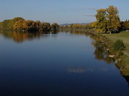 The Váh near Piešťany.
|
|
| Country | |
|---|---|
| Primary source | Čierny Váh |
| - location | Kráľova hoľa, Low Tatras |
| Secondary source | Biely Váh |
| - location | Važecká dolina, High Tatras |
| Mouth | Danube River |
| - location | Komárno |
| - elevation | 106.5 m (349 ft) |
| Length | 406 km (252 mi) |
| Basin | 15,075 km² (5,820 sq mi) |
| Discharge | |
| - average | 152 m³/s (5,368 cu ft/s) |
| - max | 1,825 m³/s (64,449 cu ft/s) |
| - min | 22.3 m³/s (788 cu ft/s) |
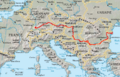
  The current and watershed of the Váh from its Čierny Váh (Southern) and Biely Váh (Northern) sources until it enters the Danube (magenta)
|
|
| Wikimedia Commons: Váh | |
The Váh (German: Waag;[1] Hungarian: Vág;[2][3] Polish: Wag) is the longest river entirely in Slovakia. A left tributary of the Danube river, the Váh is 406 km long, including its Čierny Váh branch. Its two sources, the Biely Váh (White Váh) and the Čierny Váh (Black Váh), are located in the High Tatras and Low Tatra mountains, respectively, and it flows over northern and western Slovakia and finally pours into the Danube near Komárno. The left tributaries are Demänovka, Revúca, Ľubochnianka, Turiec, Rajčanka and Nitra rivers and the right tributaries are Belá, Orava, Varínka, Kysuca, Biela voda, Vlára, Dubová, Dudváh and Malý Dunaj rivers.
It includes canals, artificial dams (Čierny Váh, Liptovská Mara, Bešeňová, Krpeľany, Žilina, Hričov, Nosice, Sĺňava, Madunice, Kráľová and Selice) and 16 hydropower stations, whose construction started in the 1930s and increased after World War II. The main Slovak limited-access motorway is situated along the Váh (Bratislava - Trenčín - Považská Bystrica - Žilina and Ružomberok - Poprad), as well as the main railway Bratislava - Žilina - Košice.
Towns on the river include Liptovský Hrádok, Liptovský Mikuláš, Ružomberok, Vrútky, Žilina, Bytča, Považská Bystrica, Púchov, Ilava, Dubnica nad Váhom, Nemšová, Trenčín, Nové Mesto nad Váhom, Piešťany, Hlohovec, Sereď, Šaľa, Kolárovo and Komárno.
References
- ↑ The Cambridge Ancient History. Cambridge University Press. 1970. ISBN 0521263352
- ↑ Kocsis, Károly (2001). Ethnic Geography of the Hungarian Minorities in the Carpathian. pp. 73. ISBN 193131375X. http://books.google.hu/books?id=-zZ_NVM9mNEC&pg=PA73&dq=Kom%C3%A1rno+Hungarians+census&sig=ACfU3U25Ug6Il7qi-T3y9yBAqQ5CaranGA. Retrieved on 2008-07-02.
- ↑ Felbermann, Louis. Hungary and Its People. http://books.google.com/books?id=zrwJAAAAIAAJ&q=V%C3%A1g+river&dq=V%C3%A1g+river&lr=lang_en&as_brr=0&hl=hu&pgis=1. Retrieved on 2008-07-02.
|
|||||||||||||||||