Utrecht (province)
| Provincie Utrecht Province of Utrecht |
|||||
|
|||||
 |
|||||
| Capital | Utrecht | ||||
| Queen's Commissioner | Mr. B. (Boele) Staal | ||||
| Religion (1999) | Protestant 27% Catholic 20% |
||||
| Area • Land • Water |
1,386 km² (12th) 63 km² |
||||
| Population (2006) • Total • Density |
1.180.039 (5th) 851/km² (3rd) |
||||
| Anthem | Langs de Vecht en d'oude Rijnstroom | ||||
| ISO | NL-UT | ||||
| Official website | www.provincie-utrecht.nl | ||||


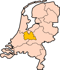
Utrecht (, IPA: [ˈyːtrɛxt]) is the smallest province of the Netherlands, and is located in the center of the country. It is bordered by the Eemmeer in the north, Gelderland in the east, the river Rhine in the south, South Holland in the west, and North Holland in the northwest. Utrecht makes up one region of the International Organization for Standardization world region code system, having the code ISO 3166-2:NL-UT. Important cities in the province are its capital (also called Utrecht), Amersfoort and Zeist.
Contents |
History
In the Middle Ages, most of the area of the current province was ruled by the Archbishopric of Utrecht. The bishopric was founded in 722 by Willibrord. Many wars were fought between Utrecht and the neighbouring counties and duchies, Holland, Gelderland and Brabant. In 1527, the bishop of Utrecht sold his worldly power over his territories to Emperor Charles V, who already owned the other Dutch provinces. However, the Habsburg rule did not last long, as Utrecht joined the revolt of the United Provinces against Charles's son Philip II of Spain in 1579. In World War II, Utrecht was held by German forces until the general capitulation of the Germans in the Netherlands on May 5, 1945. It was occupied by Canadian Allied forces on May 7, 1945. The towns of Oudewater, Woerden and Vianen were transferred from the province of South Holland to Utrecht in 1970, 1989 and 2002 respectively.
Geography

In the east of Utrecht lies the Utrechtse Heuvelrug, a chain of hills left as lateral moraine by tongues of glacial ice after the Saline glaciation that preceded the last ice age. Because of the scarcity of nutrients in the fast-draining sandy soil, the greatest part of a landscape that was formerly heath has been planted with pine plantations. The south of the province is a river landscape. The west consists mostly of meadows. In the north are big lakes formed by the digging of peat from bogs formed after the last ice age.
Municipalities
- Abcoude
- Amersfoort
- Baarn
- Breukelen
- Bunnik
- Bunschoten
- De Bilt
- De Ronde Venen
- Eemnes
- Houten
- IJsselstein
- Leusden
- Loenen
- Lopik
- Maarssen
- Montfoort
- Nieuwegein
- Oudewater
- Renswoude
- Rhenen
- Soest
- Utrecht
- Utrechtse Heuvelrug
- Veenendaal
- Vianen
- Wijk bij Duurstede
- Woerden
- Woudenberg
- Zeist
Famous Utrechters
- Gerrit Rietveld- De Stijl designer and architect the Schröder House, at Utrecht.
- Dick Bruna- Author, artist, illustrator and graphic designer, best known for creating Miffy.
- Anton Geesink
External links
- Website of the Province
- Utrecht Foreign Investment Office
- UtrechtYourWay - Tourist Information and Hotel Bookings
- Restaurant Guide of Utrecht Province
- Province maps showing subdivision in municipalities:
- Detailed Map of Utrecht
- Public transport:
|
|||||||
|
||||||||||||||||||||
