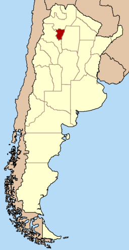
Tucumán Province
| Tucumán | |||
| Province | |||
|
|||
| Divisions | 17 departments | ||
|---|---|---|---|
| Coordinates | |||
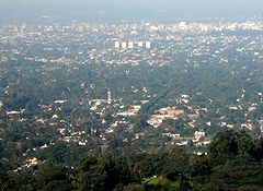
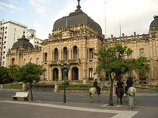
| Capital | San Miguel de Tucumán | ||
| Area | 22,524 km² (8,697 sq mi) | ||
| Population | 1,338,523 (2001) | ||
| Density | 59.4 /km² (154 /sq mi) | ||
| Governor | José Alperovich | ||
| - Senators | Carlos Salazar, Julio Miranda, Delia Pinchetti de Sierra Morales | ||
| ISO 3166-2 code | AR-T | ||
| Demonym | Tucumano | ||
 |
|||
| Website: http://www.tucuman.gov.ar | |||


Tucumán is a province of Argentina, located in the northwest of the country. The capital is San Miguel de Tucumán, often shortened to Tucumán. Neighboring provinces are from the north clockwise Salta, Santiago del Estero and Catamarca. It is nicknamed "El Jardín de la República" (The Republic's Garden).
Contents |
History


Before the Spanish colonization, this land was inhabited by the Diaguitas and Calchaquíes, who practiced agriculture.
In 1533 Diego de Almagro explored the Argentine Northwest, including Tucumán. By 1565 saw the foundation of San Miguel de Tucumán by Diego de Villaroel, and the creation of the Provincia de Tucumán, Juríes y Diaguitas, whose first governor was Francisco de Aguirre. San Miguel de Tucumán was refounded in 1685 by Miguel de Salas some 65 kilometres from its first location, in order to avoid the constant attacks of the aboriginal malones.
The local aborigines of the region presented a strong resistance to the Spanish, who decided to move the defeated tribes towards Buenos Aires, being the most famous the case of the Quilmes, who were moved to the city of Quilmes.
Tucumán was a mid-point for shipments of gold and silver from the Viceroyalty of Peru, with important cattle, textile, and wood activities that provided supplies for the convoys on their way to Buenos Aires. Because of its important geographical position, and as head of the civil and Catholic governments it acquired special importance during the 18th century.
The creation of the Viceroyalty of the Río de la Plata in 1776 meant the end of the convoys from Peru to the port of Buenos Aires. Tucumán, with 20,000 inhabitants by that time, suffered also from the British imports from the newly opened customs of Buenos Aires, no longer under the monopoly of the Spanish Crown.
In 1783 the Intendency of Tucumán was divided and Tucumán was set under the control of the Intendency of Salta del Tucumán, with its centre in Salta.
San Martín arrived to Tucumán in 1813 and installed the Military School. In 1814 the Intendency of Salta was divided into the present provinces.
On July 9 1816, at the Congreso de Tucumán, the Provincias Unidas del Río de la Plata ("United Provinces of the Río de la Plata") declared their independence from Spain, but internal conflicts delayed the final fusion of the provinces into the República Argentina.
Following the failure of Argentina's first independence-era government, the Directorate, Governor Bernabé Aráoz on March 22, 1820, proclaimed the creation of the "Federal Republic of Tucumán." The experiment collapsed, however, when the neighboring provinces of Catamarca and Santiago del Estero withdrew, the following year.
The beginning of the 20th century, with the customs restrictions and the arrival of the railway, brought prosperous economic times for the province and its sugarcane production; but, the sugar price crisis of the 1960s led President Juan Carlos Onganía to have eleven large state-owned sugar mills closed in 1966, hitting Tucumán's economy hard.[1]
The next decade saw mounting unrest due partly to economic hardship and in 1975, Pres. Isabel Perón declared a state of emergency in the province. The decree led to Operation Independence, an official military campaign at least as brutal on local magistrates, lawmakers and faculty as it was on its stated target, the ERP. Violence did not fully abate until the appointment of Gen. Domingo Bussi, the operation's commander, as governor at the behest of the dictatorship that deposed Mrs. Perón in 1976. Efficient as well as ruthless, Bussi oversaw the completion of several stalled public works; but, also presided over some of the worst human rights abuses during that painful 1976-77 period.[2] Retaining a sizable following, Bussi was elected governor in his own right in 1995, losing much of his popularity during his tenure.
Life in Tucuman has since returned to a certain normalcy and, if well its economy languished during much of the 1980s and '90s, it has recovered strongly during the expansive period Argentina has seen since 2002.
Geography


In spite of the small size of Tucumán, its necessary to distinguish two different geographical systems. The east is associated to the Gran Chaco flat lands, while the west presents a mixture of the Sierras of the Pampas to the south, and the canyons of the Argentine Northwest to the north, being the highest peak the Cerro del Bolsón with 5,550 meters.
Warm sub-tropical temperatures rein almost all over the province, but the mountain region receives more than 1,500 mm of precipitations per year, in contrast with the 600 mm of the plains. This is due to the effect of the mountains on the humid winds from the Atlantic Ocean that elevate the wind to higher, and thus colder air, forcing the condensation of the humidity and later rain.
It is because of the abundant precipitations that Tucumán has a wide area of abundant vegetation that justifies the title of Jardín de la República ("Garden of the Republic").
The Salí is the main river of the province. There are a few dams in Tucumán used for hydroelectricity and irrigation; El Cadillal on Salí River, the most important of the province, Embalse Río Hondo and Hondo River, La Angostura on de los Sosa River, and Escaba on Marapa River. The Valles Calchaquíes are crossed by the Santa María River.
Economy
Long among the most underdeveloped Argentine provinces, Tucuman has been growing strongly and, in 2006, its economy measured US$7.2 billion, the nation's 7th largest. Its per capita output of US$5,400 is nearly 40% below the national average; but, it compares favourably with that of most of its neighbors.[3]
Known internationally for its prodigious sugarcane (with 2,300 km², and the sugar production, 60% of the country's), Tucuman's economy is quite diversified and agriculture accounts for about 7% of output. After the sugar crisis of the 1960s, Tucumán tried to diversify its crops, and now cultivates, among others, lemon (world 1st. productor), strawberry, kiwifruit, beans, maize, alfalfa, and soybeans.
Cattle, sheep and goats are raised, mainly for local consumption.
Manufacturing is not prominent in Tucuman; but, still, adds about 15% to output. Besides the industrialisation of the sugarcane into sugar, paper and alcohol, there are food, textile and metallurgic industries. Among these latter, the freight-truck assembly operated by Swedish conglomerate Saab's SCANIA unit is probably the best-known. Mining is a minor activity, centred on salt, clay, lime and other non-metallic extractions.
Cultural and sport tourism is common in the province and attracts a number of Argentine tourist every year. The Panamerican Highway (Route 9) crosses San Miguel de Tucumán and connects it with Santiago del Estero and Buenos Aires. The city also serves as a mid-stop for tourists visiting other provinces of the Argentine Northwest. The Benjamín Matienzo airport receives over half a million visitors per year.
the most visited destinations of the province are the Campo de los Alisos National Park, Valles Calchaquíes, Tafí del Valle, Quilmes' Ruins, the Diaguitas' community of Amaicha del Valle, and the city of San Miguel de Tucumán.
There are 4 important universities in Tucumán the Universidad Nacional de Tucumán (with 60,000 students), the Universidad Tecnológica Nacional UTN - Facultad Regional Tucumán, Universidad del Norte Santo Tomás de Aquino and the Universidad San Pablo T
Political division


The province is divided into 17 departments (Spanish departamentos).
| Department | Population | Area | Seat |
|---|---|---|---|
| Burruyacú | 32,936 | 3,605 km² | Burruyacú |
| Capital | 527,607 | 90 km² | San Miguel de Tucumán |
| Chicligasta | 75,133 | 1,267 km² | Concepción |
| Cruz Alta | 162,240 | 1,255 km² | Banda del Río Salí |
| Famaillá | 30,951 | 427 km² | Famaillá |
| Graneros | 13,063 | 1,678 km² | Graneros |
| Juan Bautista Alberdi | 28,206 | 730 km² | Juan Bautista Alberdi |
| La Cocha | 17,683 | 917 km² | La Cocha |
| Leales | 51,090 | 2,027 km² | Bella Vista |
| Lules | 57,235 | 540 km² | Lules |
| Monteros | 58,442 | 1,169 km² | Monteros |
| Rio Chico | 52,925 | 585 km² | Aguilares |
| Simoca | 29,932 | 1,261 km² | Simoca |
| Tafí del Valle | 13,883 | 2,741 km² | Tafí del Valle |
| Tafí Viejo | 108,017 | 1,210 km² | Tafí Viejo |
| Trancas | 15,473 | 2,862 km² | Trancas |
| Yerba Buena | 63,707 | 160 km² | Yerba Buena |
References
- ↑ http://www.arztucuman.org.ar/pap/capitulo3_pap_1_2.htm Archdiocesis of Tucumán
- ↑ Andersen, Martin. Dossier Secreto. Westview Press, 1993.
- ↑ I.A.D.E.R
External links
- Tucuman NoroesteArgentino.com Tucuman | Norte Argentino
- Tucuman.gov.ar Tucuman Province Official Website
- Tucuman.com Tucumán portal website
- Turismo en Tucuman Local Website with tourist information
- Ruta Urbana - Apoyando a la Cultura Tucumana en Television
- La Gaceta The most important local newspaper
- El Siglo Web Online edition of this local newspaper
- Primera Fuente Online webpaper
- Tucuman al Dia Online webpaper
- Tucuman Diario Online webpaper
- Tucuman Noticias Online webpaper
- Esto es Tucuman Local webzine about politics, media, general issues, etc.
- Tucumanos More pictures of Tucuman
- Universidad Nacional de Tucumán Tucuman State University
- Universidad del Norte Santo Tomas Aquino Tucuman Catholic University
- Universidad Tecnologica Nacional (Tucuman Campus)
- Legion Tucuman Paintball Club
|
||||||||||