Trenčín
| Trenčín | ||
| City | ||
 Trenčín Castle from bridge crossing Váh river
|
||
|
||
| Country | ||
|---|---|---|
| Region | Trenčín | |
| District | Trenčín | |
| Tourism region | Považie | |
| River | Váh | |
| Elevation | 211 m (692 ft) | |
| Coordinates | ||
| Area | 81.996 km² (31.66 sq mi) | |
| Population | 56,760 (2006-12-31) | |
| Density | 692 /km² (1,792 /sq mi) | |
| First mentioned | circa 150 | |
| Mayor | Branislav Celler (SDKÚ) | |
| Timezone | CET (UTC+1) | |
| - summer (DST) | CEST (UTC+2) | |
| Postal code | 91101 | |
| Area code | +421-32 | |
| Car plate | TN | |
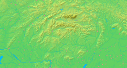  Location in Slovakia
|
||
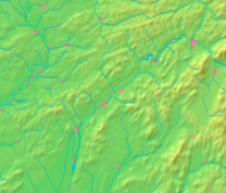  Location in the Trenčín Region
|
||
| Wikimedia Commons: Trenčín | ||
| Statistics: MOŠ/MIS | ||
| Website: www.trencin.sk | ||

Trenčín (pronunciation; also known under alternative names) is a city in western Slovakia of the central Váh River valley near the Czech border, around 120 km from Bratislava. It has a population of more than 56,000, which makes it the ninth largest municipality of the country and is the seat of the Trenčín Region and the Trenčín District. It has a medieval castle, standing on a rock above the city.
Contents |
Names
It was first mentioned under Greek name Leukaristos, depicted on the Ptolemy world map around 150 CE. During the course of the Marcomannic Wars between the Roman Empire and Germanic Quadi, the Romans carved an inscription on the rock under the present-day castle in 179 CE and the place was mentioned as Laugaricio. It is the northernmost known presence of the Romans in Central Europe.
The first written mentions in the Middle Ages are from 1111 (as Treinchen) and 1113 (adjective Trenciniensis). The German and Hungarian forms are Trentschin and Trencsén, respectively.
History
The site of Trenčín has been inhabited since time immemorial. Trenčín Castle, a typical medieval fortified castle is situated high on a rock above the city. Trenčín is best known for a Roman inscription on the rock below the Trenčín Castle dating from 179 AD, the era of the Marcomannic Wars, a series of wars between the Roman Empire and the Germanic Quadi. It denotes the site as Laugaricio and is the most northern evidence of the presence of Roman soldiers in central Europe.
It is plausible that Trenčín Castle was founded during the Great Moravian era. By the end of the 11th century it had become the administrative centre of Trenčín county. As one of the few stone castles in the Kingdom of Hungary it resisted the disastrous invasion of Mongols in 1241. In 1263 Trenčín was in the possession of Jakab Cseszneky royal swordbearer, but in 1302 King Wenceslas I took it away from the Cseszneky brothers because they were supporting his rival Charles Robert, and donated it to Matthew Csák. Between 1302 and 1321 the castle was the seat of the powerful magnate Matthew Csák who controlled most of what is now present-day Slovakia. Challenging the authority of king Charles Robert, Matthew Csák maintained a large court and pursued his own foreign policy. The Treaty of Trentschin between Bohemia, Hungary, and Poland was signed in the city in 1335.
Trenčín gained a number of privileges during the Middle Ages: In 1324 the inhabitants were freed from paying tolls and the city received free royal town privileges in 1412 from King Sigismund. However during the following decades and centuries there were catastrophes and wars which lasted until the end of the 18th century. During the conflict between the Habsburgs and the supporters of the rival king, János Szapolyai, the town was captured in 1528 by imperial troops. In the 17th century the Ottomans were another threat from the south but they failed to conquer the city. The town then suffered from the Kuruc uprising against the Habsburgs and on 3 August 1708 the Battle of Trenčín took place close to the city. Two years later a plague killed 1,600 inhabitants of the city. Finally, in 1790 the town, along with the castle, was burned down and the castle has been in ruins ever since.
In the 19th century Trenčín flourished, as the railways to Žilina and Bratislava were built and many new enterprises were established, particularly in the textile, food and machine industries, and the town became the hub of the middle Považie (Váh) region. In 1867 Trenčín was downgraded from a "free royal town" to a "town with municipal government" and came under the direct control of the chief of Trenčín county. Trenčín flourished again during the era of the first Czechoslovak republic and became the capital of the Trenčín county again between 1940-1945 when the puppet Slovak Republic was in existence. Shortly after the Slovak National Uprising began, Trenčín was occupied by Nazi Germany and it became the headquarters of the Sicherheitsdienst and the Gestapo and a prison camp was placed there. Trenčín was captured by the Soviet troops on 10 April 1945.
Since 1990, the historical centre of the city has been largely restored and since 1996 it has been the seat of Trenčín Region and Trenčín District.
Geography
Trenčín lies at an altitude of 362 metres (1,188 ft) above sea level and covers an area of 81.996 square kilometres (31.7 sq mi).[1] It lies in the Trenčín Basin of north-western Slovakia, which is surrounded by the Strážov Mountains, Považský Inovec and White Carpathians, with the last mentioned being a protected area. The Váh River flows in the north-south axis.
Climate
Trenčín lies in the north temperate zone and has a continental climate with four distinct seasons. It is characterized by a significant variation between hot summers and cold, snowy winters.
| Month | Jan | Feb | Mar | Apr | May | Jun | Jul | Aug | Sep | Oct | Nov | Dec | |
|---|---|---|---|---|---|---|---|---|---|---|---|---|---|
| Average high °C (°F) | 2 (35) |
4 (40) |
10 (49) |
16 (60) |
21 (70) |
24 (75) |
26 (79) |
26 (79) |
21 (70) |
15 (59) |
7 (45) |
3 (37) |
|
| Average low °C (°F) | -4 (25) |
-3 (26) |
0 (33) |
4 (40) |
9 (49) |
12 (54) |
14 (56) |
14 (57) |
10 (50) |
6 (43) |
2 (35) |
-2 (28) |
|
| Precipitation cm (inches) | 1.78 (0.70) |
2.11 (0.83) |
2.15 (0.85) |
3.15 (1.24) |
3.83 (1.51) |
4.90 (1.93) |
4.83 (1.90) |
3.53 (1.39) |
4.05 (1.59) |
2.89 (1.14) |
3.09 (1.22) |
2.85 (1.12) |
|
| Source: MSN Weather[2] 2008-01-18 | |||||||||||||
Tourism and sights

The city is dominated by Trenčín Castle, which is the third-largest castle in Slovakia. Trenčín Castle is divided into upper and lower sections, with extensive fortifications. The upper castle has several palace buildings which surround the central medieval tower, which remains the highest point of the city. Below the castle, on the hillside, is the old parish church and a small upper square which is reached by historic covered stairs as well as by winding side streets. The old town has a large main square, with a large baroque church and a variety of shops, as well as a town tower.
Pohoda, the most visited music festival in Slovakia,[3] has been organized in Trenčín since 1997. As of 2008, it takes place at the Trenčín Airport.
Demographics

In 2005 the city had a population of 56,750. The population density was 692/km². According to the 2001 census the religious makeup was: 65.8% Roman Catholics, 22.3% people with no religious affiliation, and 7.1% Lutherans. 95.3% inhabitants were Slovaks and 2.4% Czechs.[4]
Sport
Football (soccer) club FK AS Trenčín is based in the city and plays in the Corgoň Liga. The Ice hockey club HC Dukla Trenčín plays in the Slovak Extraliga and is a four time winner of the domestic league.
Education

Trenčín is the seat of the public Alexander Dubček University with 7,140 students, including 110 doctoral students.[5] and of private College of Management in Trenčín with 1,275 students.[6]. The city's system of primary education consists of nine public schools and one religious primary school, enrolling in overall 4,623 pupils.[7] Secondary education is represented by five gymnasia with 1,974 students,[8], 5 specialized high schools with 1,892 students,[9] and 6 vocational schools with 3,975 students.[10][11]
Transport
Trenčín lies near the main Slovak motorway and is an important stop on the main railway line from Bratislava to Žilina and Košice. Roads from the city also lead into the Czech Republic and Prievidza/Nitra. Railway tracks from the aforementioned cities end in Trenčín.
Territorial division
Trenčín is divided into four main boroughs:
- Stred:Stred mesta, Dolné mesto, Dlhé Hony, Noviny, Biskupice
- Juh:Juh I-II
- Sever:Sihoť I-IV, Opatová nad Váhom, Pod Sokolice, Kubrá, Kubriská
- Západ:Zámostie, Kvetná, Istebník, Orechové, Zlatovce, Nové Zlatovce, Záblatie
Sister Cities
 Cran-Gevrier, France
 Uherské Hradiště, Czech Republic
- Zlín, Czech Republic
 Tarnów, Poland
 Casalecchio di Reno, Italy
 Békéscsaba, Hungary
 Kragujevac, Serbia
See also
- List of people from Trenčín
References
- ↑ "Municipal Statistics". Statistical Office of the Slovak republic. Retrieved on 2007-05-03.
- ↑ "Monthly Averages for Trenčín, Slovakia". MSN. Retrieved on 18 January, 2007.
- ↑ "Pohoda wants to be the best, not the largest (Pohoda nechce byť najväčšia, ale najlepšia)". Palo Hlubina, eTREND (April 26, 2008). Retrieved on April 28, 2008.
- ↑ Mestská a obecná štatistika SR
- ↑ "Trenčianska univerzita Alexandra Dubčeka" (PDF) (in Slovak). Ústav informácií a prognóz školstva. Retrieved on 2008-03-03.
- ↑ "Vysoká škola manažmentu" (PDF) (in Slovak). Ústav informácií a prognóz školstva. Retrieved on 2008-03-03.
- ↑ "Prehľad základných škôl v školskom roku 2006/2007" (PDF) (in Slovak). Ústav informácií a prognóz školstva (2006). Retrieved on 2008-03-03.
- ↑ "Prehľad gymnázií v školskom roku 2006/2007" (PDF) (in Slovak). Ústav informácií a prognóz školstva. Retrieved on 2008-03-03.
- ↑ "Prehľad stredných odborných škôl v školskom roku 2006/2007" (PDF) (in Slovak). Ústav informácií a prognóz školstva. Retrieved on 2008-03-03.
- ↑ "Prehľad združených stredných škôl v školskom roku 2006/2007" (PDF) (in Slovak). Ústav informácií a prognóz školstva. Retrieved on 2008-03-03.
- ↑ "Prehľad stredných odborných učilíšť a učilíšť v školskom roku 2006/2007" (PDF) (in Slovak). Ústav informácií a prognóz školstva. Retrieved on 2008-03-03.
External links
- Official city website
- Trenčín travel guide from Wikitravel
- Trenčín information
- Satellite picture of the Trenčín Castle
|
|||||||
|
|||||||