Tauranga
- for the electorate see Tauranga (NZ electorate)
| Tauranga Tauranga-moana (Māori) |
|
| — Metropolitan Area — | |
 |
|
| Coordinates: | |
| Country | |
|---|---|
| Region | Bay of Plenty |
| Territorial authority | Tauranga City |
| Settled by the UK | 1838 |
| Electorate(s) | Tauranga Bay of Plenty |
| Government | |
| - MP (Tauranga) | Simon Bridges (National) |
| - MP (Bay of Plenty) | Tony Ryall (National) |
| - Mayor | Stuart Crosby |
| Area | |
| - Metropolitan Area | 168 km² (64.9 sq mi) |
| Population (June 2008 estimate)[1] | |
| - Metropolitan Area | 110,500 |
| - Density | 657.7/km² (1,703.5/sq mi) |
| - Urban | 116,000 |
| Time zone | NZST (UTC+12) |
| - Summer (DST) | NZDT (UTC+13) |
| Area code(s) | 07 |
| Website: http://www.tauranga.govt.nz/ | |
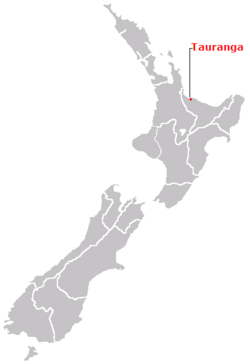
Tauranga (population 116,000 June 2008 estimate[1]) is the largest city of the Bay of Plenty region of the North Island of New Zealand. Tauranga is 205 km (127 mi) south-east of Auckland, 105 km (65 mi) east of Hamilton and 85 km (53 mi) north of Rotorua,
The "City of Tauranga" was reproclaimed in 2004,[2] after status was lost after 1989 Local Body reforms. The City of Tauranga includes the major suburbs/areas of Tauranga City's Central Business District, The Avenues, Matua, Tauriko (being built), Otumoetai, Bethlehem, Greerton, Ohauiti, Maungatapu and Welcome Bay, as well as the city's northern coastal strip of Mount Maunganui, Omanu, Arataki, Bayfair and Papamoa.
As of 2008, the city population is growing quickly at an annual rate of 1.5%, with Papamoa expected to be a small city in itself by 2020, with a population the size of Nelson.[3]
Contents |
Location
Tauranga is located around a large harbour which extends along the western Bay of Plenty, and is protected by Matakana Island and the extinct volcano of Mauao.
The name Tauranga comes from Māori, it roughly translates to "a sheltered anchorage".
Due to its sheltered position on the east coast, Tauranga enjoys a warm, dry climate. This has made it a popular location to retire to. During the summer months the population swells as the holidaymakers descend on the city, especially along the popular white coastal surf beaches from Mount Maunganui to Papamoa.
Situated along a faultline, Tauranga & the Bay of Plenty experience infrequent seismic activity, and there are a few volcanoes around the area (mainly dormant). The most notable of these are White Island and Mauao (Mount Maunganui), nicknamed "The Mount" by many locals).
Much of the countryside surrounding Tauranga is horticultural land, used to grow a wide range of fresh produce for both domestic consumption and export. The area is particularly well known for growing tangelos (a grapefruit / tangerine cross), avocados, and kiwifruit. Recent years have seen the establishment of boutique vineyards and wineries.
The Port of Tauranga is New Zealand's largest export port, with brisk but seasonal shipping traffic. It is a regular stop off for both container ships and luxury cruise liners.


Population
It is the ninth largest New Zealand city and the centre of the fifth largest urban area, just recently taking over Dunedin, growing at a rate of 1.5% as of 2008.
Attractions
Greater Tauranga is a very popular retirement and tourism destination. It features many natural attractions and scenery.
Due to the temperate climate, outdoor activities are very popular in Tauranga, including golf, tramping (hiking), mountain biking and white water rafting. The Bay of Plenty coastline features miles of golden sandy beaches, and watersports are very popular pastimes. The most common include swimming, surfing, fishing, diving, kayaking & kitesurfing. Tourists also enjoy dolphin-watching on specially run boat trips.
The Montana Jazz Festival takes place in Tauranga every Easter, with dozens of live acts, good food and excellent wine.
History
First settlers
The earliest known settlers arrived from the Takitimu and Mataatua waka in the 12th century. It was named "Tauranga", meaning "landing place".[4]
Early trading
Traders in flax were active in the Bay of Plenty during the 1830s; some were transient, others married local women and settled permanently. The first permanent trader was James Farrow, who traveled to Tauranga in 1829, obtaining flax fibre for Australian merchants in exchange for muskets and gunpowder. Farrow acquired half an acre of land on 10 January 1838 at Otumoetai Pā from the chiefs Tupaea, Tangimoana and Te Omanu, the earliest authenticated land purchase in the Bay of Plenty.[5]
Missionaries
During the 1820s, missionaries from the Bay of Islands visited the Tauranga district to obtain supplies of potatoes, pigs and flax. In 1840, a Catholic mission station was established. Bishop Pompallier was given land within the palisades of Otumoetai Pā for a church and a presbytery. The mission station closed in 1863 due to land wars in the Waikato district.
Māori Wars
The Tauranga Campaign took place in and around Tauranga, from 21 January 1864 to 21 June 1864, during the Māori Wars. The Battle of Gate Pa is the most well-known.
Modern age
As of 2008, Tauranga is a fast growing city in New Zealand. The population at the June 2008 estimate was 116,000,[1] meaning that the city has tripled in size in a little over 25 years. The population increase is due mostly to retirees settling in the city, and sun and surf seekers. It is also a popular lifestyle city. Although the population has increased dramatically, the city is proportionally underrepresented in businesses other than retail which is over-saturated, and the CBD reflects a city of less than half the population as that of Tauranga. This is mainly because of many outer suburb areas having shopping centres including Fraser Cove, Fashion Island and Palm Beach Plaza spreading retail dollars thin in the area as property values and rents are very high. Tauranga has earned the nickname "ten dollar Tauranga" in the past, due to low wage rates, but wages have increased and even the minimum wage is now $12 per hour.[6]
Under the Local Government (Tauranga City Council) Order 2003,[7] Tauranga became (legally) a city for a second time from 1 March 2004.
Geography
Climate
| Month | Jan | Feb | Mar | Apr | May | Jun | Jul | Aug | Sep | Oct | Nov | Dec | Year |
|---|---|---|---|---|---|---|---|---|---|---|---|---|---|
| Average high °C (°F) | 23.9 (75) |
23.8 (75) |
22.3 (72) |
19.9 (68) |
17.1 (63) |
14.9 (59) |
14.3 (58) |
14.9 (59) |
16.3 (61) |
18 (64) |
20 (68) |
21.9 (71) |
18.9 (66) |
| Average low °C (°F) | 14.5 (58) |
14.7 (58) |
13.5 (56) |
10.9 (52) |
7.9 (46) |
6 (43) |
5.2 (41) |
6.1 (43) |
7.8 (46) |
9.3 (49) |
11.3 (52) |
13.1 (56) |
10 (50) |
| Precipitation mm (inches) | 74 (2.91) |
78 (3.07) |
128 (5.04) |
105 (4.13) |
91 (3.58) |
128 (5.04) |
122 (4.8) |
115 (4.53) |
104 (4.09) |
94 (3.7) |
85 (3.35) |
87 (3.43) |
1,198 (47.17) |
| Source: NIWA Climate Data[8] 1971 – 2000 | |||||||||||||
Education
Tauranga is home to the Bay of Plenty Polytechnic as well as a branch of the University of Waikato.
State secondary schools include:
- Aquinas College a co-educational state-integrated Catholic school founded in 2003 for years 7 through 13.
- Tauranga Boys' College, with over 1500 boys.
- Tauranga Girls' College, with over 1500 girls.
- Otumoetai College, with around 1900 pupils.
- Bethlehem College-A Christian educational institution for kindergarten, primary and secondary level students
- Mount Maunganui College a co-educational secondary school.
Christian educational institutions in Tauranga include Bethlehem Campus, a college for both children and adults established in 1988; Tauranga Adventist School,a state integrated Christian community school catering for Year 1 to 8 students and established in 1974; and Aquinas College, a Catholic college established in 2003.
Notable residents
- Hilda Hewlett - pioneer aviator
- Phil Rudd - drummer for AC/DC
- Richard O'Brien - author of The Rocky Horror Show (spent his formative years here)
- Les Munro - Dambusters veteran.
- Bob Clarkson - Member of Parliament and successful property developer and landlord
- Sheryl Jordan - Prominent New Zealand Teen Fiction/Fantasy author
- Tim Balme - Actor, director
- Winston Peters - Former MP for Tauranga, leader of NZ First, politician
Sister cities
 Yantai, China
 Hitachi, Ibaraki, Japan[9]
See also
- Port of Tauranga
- Tauranga Botanica
References
- ↑ 1.0 1.1 1.2 "Subnational Population Estimates: At 30 June 2008". Statistics New Zealand (23 October 2008). Retrieved on 2008-10-28.
- ↑ "When did Tauranga District Council officially change its name to Tauranga City Council?". Tauranga City Council.
- ↑ According to SmartGrowth, from Census growth figures and Statistics NZ.
- ↑ VTours - Downtown Tauranga
- ↑ http://ourcity.tauranga.govt.nz/heritage/history/traders/
- ↑ "Bay of Plenty places - Tauranga". Te Ara Encyclopedia of New Zealand. Retrieved on 2007-10-24.
- ↑ http://www.knowledge-basket.co.nz/regs/regs/text/2003/2003275.txt
- ↑ "Climate Data". NIWA. Retrieved on November 2, 2007.
- ↑ Sister cities
External links
- www.tauranga.co.nz Your portal for everything in Tauranga, NZ... Look Further...
- Tourism Bay Of Plenty portal site
- Tauranga City Council
- Tauranga City Libraries
- Local History portal — Tauranga City Libraries
- Tourist's' guide to the Western Bay
- Local newspaper — The Bay of Plenty Times
- Street Map of Tauranga
|
|||||||||||||||||
|
||||||||||||||||||||||||||