Taguig City
| The City of Taguig Lungsod ng Taguig |
|||
 |
|||
|
|||
| Nickname(s): Home of the Global City | |||
| Motto: Forward Taguig | |||
 |
|||
| Country | Philippines | ||
|---|---|---|---|
| Region | National Capital Region | ||
| Districts | 1st and 2nd Districts of Taguig City | ||
| Barangays | 18 | ||
| Incorporated (town) | April 25, 1587 | ||
| Incorporated (city) | December 8, 2004 | ||
| Government | |||
| - Mayor | Freddie Tinga (2007-2010; Lakas-CMD/KDT) | ||
| - Vice Mayor | George Elias (2007-2010; Lakas-CMD/KDT) | ||
| Area | |||
| - Total | 47.88 km² (18.5 sq mi) | ||
| Elevation | 16.0 m (52 ft) | ||
| Population (2007)[1] | |||
| - Total | 613,343 | ||
| Time zone | PST (UTC+8) | ||
| Zip code | 1630 to 1638 | ||
| Area code(s) | 2 | ||
| Website: www.taguig.gov.ph/ | |||

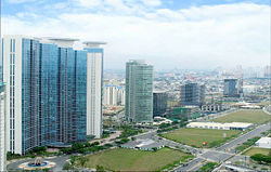
Taguig (formerly spelled as Tagig; Filipino: Lungsod ng Taguig) is a city in Metro Manila in the Philippines. From a thriving fishing community along the shores of Laguna de Bay, it is now an important residential and industrial suburb of Manila. The recent construction of the C-5 highway and the acquisition of the Fort Bonifacio development area has paved the way for the cityhood of the municipality.
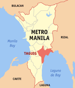
Taguig City lies on the western shore of Laguna de Bay and is bordered by Muntinlupa City to the south, Parañaque City to the southwest, Pasay City to the west, Cainta and Taytay on the northeast and Makati City, Pateros, and Pasig City to the north. Taguig River, a tributary of the Pasig River cuts through the northern half of the municipality and Napindan River, also a tributary of the Pasig forms the common border of Taguig with Pasig City.
The city ranked first among Philippine cities in the Ease of Doing Business Index, conducted by the World Bank's International Finance Corporation[2].
Contents |
Barangays
Taguig City is politically subdivided into 18 barangays together with Fort Bonifacio as a special economic and development district.
| Barangay | District | Population (2007)[1] |
|---|---|---|
| Bagong Tanyag | 2nd | 43,452 |
| Bagumbayan | 1st | 31,777 |
| Bambang | 1st | 6,199 |
| Calzada | 1st | 14,822 |
| Hagonoy | 1st | 21,181 |
| Ibayo-Tipas | 1st | 18,031 |
| Ligid-Tipas | 1st | 7,839 |
| Lower Bicutan | 1st | 79,886 |
| Maharlika Village | 2nd | 16,474 |
| Napindan | 1st | 11,623 |
| Palingon | 1st | 10,625 |
| Santa Ana | 1st | 14,946 |
| Signal Village | 2nd | 107,906 |
| Tuktukan | 1st | 8,011 |
| Upper Bicutan | 2nd | 62,570 |
| Ususan | 1st | 25,182 |
| Wawa | 1st | 8,662 |
| Western Bicutan | 2nd | 124,157 |
In 2008, the Taguig City government has started the creation of six new barangays to ensure the delivery of services and address the needs of the growing number of Taguig residents. The Sangguniang Panglungsod (City Council) approved City Ordinance Nos. 24-27, 57-61, 67-69 and 78.[3][4]
| Barangay | Population (2007) |
|---|---|
| Hagonoy | 14,748 |
| San Miguel | 6,433 |
| North Daang Hari | 10,049 |
| South Daang Hari | 15,119 |
| Tanyag | 18,284 |
| Central Bicutan | 24,291 |
| Upper Bicutan | 38,279 |
| Katuparan | 14,885 |
| North Signal Village | 27,960 |
| Central Signal Village | 31,364 |
| South Signal Village | 33,697 |
| Pinagsama | 32,777 |
| Fort Bonifacio | 20,741 |
| Western Bicutan | 70,639 |
| New Lower Bicutan | 35,798 |
| Lower Bicutan | 44,088 |
- From Barangay Hagonoy
- From Barangay Bagong Tanyag
- From Barangay Upper Bicutan
- From Barangay Signal Village
- From Barangay Western Bicutan
- From Barangay Lower Bicutan
History
Before the Spaniards came, Taguig was a part of Kingdom of Tondo ruled by Rajah Soliman. There were also accounts that Chinese settlements were once present in the area as revealed by the recent archeological diggings of various artifacts like glasses, cups, plates and other utensils, which bear Chinese characters. This was believed to have originated from China's Ming dynasty.
Taguig was one of the earliest known territories to have been Christianized when the Spaniards succeeded in subjugating mainland Luzon through the Legazpi expedition in 1571. Between the years 1582 and 1583, Taguig was of the encomienda of Tondo headed by an Alcalde Mayor, Captain Vergara. It was in 1587 when Taguig was established as a separate "pueblo" (town) of the then province of Manila. Captain Juan Basi was its Kapitan from 1587 to 1588. According to records, Taguig had nine (9) barrios then namely, Bagumbayan, Bambang, Hagonoy, Palingon, Sta. Ana, Tipas, Tuktukan, Ususan, and Wawa. Records show that Tipas had once petitioned to become an independent town but was denied by the Spanish government.
During that time, Taguig was accessible via the Pasig River, which was connected to two large bodies of water, the Manila Bay and Laguna de Bay. The population then was estimated to be 800 tributes. The town produced more than enough rice for their consumption but had less sugar cane to mill. The men lived through fishing while women wove cotton cloth and "sawali" from bamboo strips.
The people of Taguig were known to have resisted both Spanish and American colonial rule. During that early period of Spanish colonition. Don Juan Basi, "Kapitan" of Taguig from 1587 to 1588, attempted to overthrow the Spanish government but failed, being exiled for two years as punishment. When then Katipunan was on its early years, many from Taguig became followers and later joined the uprising. The people of Taguig also joined the revolutionary government of General Emilio Aguinaldo on August 6, 1898.
During the American occupation, they struggled against the forces of General Wheaton under the command of General Pio del Pilar. It was recorded that on February 6, 1889, Filipino forces including Taguig "revolutionarios" dislodged an American position in the hills of Taguig, now a portion of Pateros and Fort Bonifacio. They were defeated eventually by the Americans with superiority in the armaments and training. Taguig finally fell to the contingent of the First Washington Volunteer Infantry led by Col. Wholly.
The defeat of the Filipinos after two years of struggle against the American forces subsequently subjected the Philippines to another system of governance. On August 14, 1898, United States occupied the islands and established a military government with General Wesley Meritt as the First Military Governor. He exercised legislative powers until September 1, 1900.
At the start of American regime, Taguig was proclaimed as an independent municipality with the promulgation of General Order No. 4 on March 29, 1900. The town was subsequently incorporated to the newly created province of Rizal when the Philippine Commission promulgated Act. No. 137 on June 11, 1901. On October 12, 1903, Taguig, Muntinlupa and Pateros were merged by the virtue of Act. No. 942 with Pateros hosting the seat of the municipal government. The merger did not last long as a month later Muntinlupa was segregated from it and made part of Biñan when Act. No. 1008 was enacted on November 25, 1903. However it was returned to Taguig on March 22, 1905 with the promulgation Act. No. 1308. On February 29, 1908, Taguig was again declared an independent municipality through Executive Order No. 20. Eventually, Pateros separated from Taguig and both became independent municipalities of Rizal province on January 1, 1918.
It was also during the American Colonial Period that the US government acquired a 25.78 km² property of Taguig for military purposes. This large piece of land which had a TCT dated 1902, was turned into a camp and was then known as Fort McKinley(named after the 25th president of US Pres. William McKinley). When the Japanese occupied the Philippines in 1942, Fort McKinley was taken over by the Japanese Imperial Army. They occupied the military camp until the end of the war in 1945.
After the Philippines gained its political independence from the United States on July 4, 1946, the US surrendered the Republic of the Philippines all right of possession, jurisdiction, supervision and control over the Philippine territory except the used of the military bases. On May 14, 1949, Fort McKinley was turned over to the Philippine government by virtue of the US embassy Note No. 0570.
Fort McKinley was made the permanent headquarters of the Philippine Army in 1957 and was subsequently renamed Fort Bonifacio after the Father of the Philippine Revolution against Spain, Andres Bonifacio.
The town's political subdivision was changed to barangays following the nationwide implementation of the Integrated Reorganization Plan (IRP) in the 1970s when the country was under Martial Law. The IRP has increased its subdivisions into 18 barangays, namely, Bagong Tanyag, Bagumbayan, Bambang, Calzada, Hagonoy, Ibayo-Tipas, Ligid-Tipas, Lower Bicutan, Maharlika, Napindan, Palingon, Signal Village, Sta. Ana, Tuktukan, Upper Bicutan, Ususan, Wawa, and Western Bicutan. Soon to be added to its jurisdiction is Barangay Fort Bonifacio. On November 7, 1975, Taguig was carved out from the province of Rizal to form the National Capital Region through Presidential Decree No. 824. Today, Taguig is still one of the seventeen (17) cities and municipalities that make up Metro Manila.
In 1998, a bill was passed in Congress pushing for the cityhood of Taguig. The resulting plebiscite in April showed that the citizens were against cityhood. A recent petition to the Supreme Court sought a recount of the plebiscite and the Supreme Court on February 19, 2004 ordered the Commission on Elections to conduct a recount. The recount showed that the residents did want the municipality of Taguig to become a city (21,105 'yes' and 19,460 'no'). Subsequently, Taguig became a city on December 8, 2004.
Education
PUBLIC - Primary
PUBLIC - Secondary
|
PUBLIC - Tertiary
PRIVATE - Primary to Secondary
|
PRIVATE - Primary to Tertiary
PRIVATE - Tertiary
PRIVATE - International Schools
|
Taguig City is home to several prestigious international schools such as the Manila Japanese School, International School Manila and British School Manila, which are all located in the University Parkway of Bonifacio Global City.
The Chinese International School Manila is in the nearby area of McKinley Hill. Enderun Colleges and the Korean International School are also set to open in McKinley Hill soon. Other schools in Fort Bonifacio are the Global City Innovative College, Everest Academy (the only Catholic run International School in the Philippines), Victory Leadership Institute and MGC-New Life Christian Academy.
Two of the top state universities are also in Taguig City--the Polytechnic University of the Philippines, and the Technological University of the Philippines. Both universities are located in Bicutan, Taguig City.
The Technical Education and Skills Development Authority (TESDA) was established through the enactment of "Technical Education and Skills Development Act of 1994", which was signed into law by President Fidel V. Ramos. This Act aims to encourage the full participation of and mobilize the industry, labor, local government units and technical-vocational institutions in the skills development of the country's human resource. The TESDA complex and facilities are located at the East Service Road of the South Luzon Expressway in Taguig City.
The Philippine Public Safety College in Fort Bonifacio is an educational institution offering undergraduate and graduate programs for the training, human resource development and continuing education of police, fire and jail personnel.
Taguig City has two Islamic educational institutions located in Maharlika Village--the Maharlika Bandara-Inged Integrated School and the Maharlika Village Islamic Madrasa.
Other notable schools in Taguig City are the city-run Taguig Science High School in Hagonoy, the Catholic Church-owned Colegio de Sta. Ana (Formerly Sta. Ana Parochial School), The Fisher Valley College, a Christian school in Hagonoy, and St. Francis College, a Catholic school in Bagumbayan.
The Pamantasan ng Lungsod ng Taguig (University of Taguig City) started their operations in November 2006 with night classes at two of the city's larger secondary schools. Construction of a school building will follow soon at a lot beside Taguig City Hall of Justice in Lower Bicutan. A fully-operational campus is targeted by 2009.[5]
Conflict

Makati City and Taguig have recently fought over the jurisdiction of Fort Bonifacio. This Philippine military base, most of which has been converted to a modern commercial and residential development area, lies in an ambiguous area. A portion of the base, including the Libingan ng mga Bayani (Cemetery for the Heroes) and the Manila American Cemetery and Memorial lies within Taguig, while the northern portion where the development center is now located used to be considered part of Makati. A 2003 ruling by a judge in the Pasig Regional Trial Court has upheld the jurisdiction of Taguig over the whole of Fort Bonifacio, including the Fort Bonfacio Global City.
Ruling
The Supreme Court on June 27, 2008 per Leonardo Quisumbing, dismissed the suit of the Makati City, seeking to nullify Special Patents 3595 and 3596 signed by Fidel Ramos conveying to the Bases Conversion and Development Authority public land in Fort Bonifacio, Taguig City. Because of a pending civil case filed by the Taguig City government asking the court to define its territorial boundaries, Makati therefore cannot yet stop Taguig from collecting taxes on land located in Fort Bonifacio.[6][7][8]
Landmarks
- Food Terminal, Inc. (FTI) - the business center that boasts of over 300 medium scale companies in food manufacturing, electronics, garments and service industries.
- Camp Bagong Diwa - The camp is in Bicutan, it is where NCRPO headquarters, prison complex and drug rehabilitation centers are located.
- Department of Science and Technology - A mini forest and eco-tourism park in Bicutan suitable for camping and bivouac activity. It is the national headquarters of the DOST.
- Veterans' Museum - A museum where war stories in life-sized tableaus are retold using all forms of art fused with high-end technology.
- The Blue Mosque - A religious center and a socio-civic rendezvous for both Filipino and foreign Muslims in Maharlika Village.
- Bantayog ng Bayani - A fitting tribute to the heroes of Taguig during the WWI at Fort Bonifacio.
- Shrine of St. Anne - Built in 1587 in Sta. Ana, one of the Philippines' oldest churches.
- Dambanang Kawayan - A century old church in Tipas made of pure, native bamboo. It was inaugurated as a parish in 1969, comprising barangays Ligid-Tipas, Ibayo-Tipas, Calzada, and Palingon.
- Museo de Sta. Ana - A museum at the Shrine of St. Anne. The repository of artifacts detailing the rich religious culture and history of Taguig since 1857.
Government
Current Officials (2007-2010)
| Position | Name |
|---|---|
| Mayor | Sigfrido R. Tiñga |
| Vice Mayor | George A. Elias |
| 1st District | |
| Representative | Ma. Laarni L. Cayetano |
| Councilors | Allan Paul C. Cruz |
| Delio J. Santos | |
| Gamaliel N. San Pedro | |
| Ronette O. Franco | |
| Baltazar T. Mariategue | |
| Jaime R. Labampa | |
| Darwin C. Icay | |
| Baby Gloria V. de Mesa | |
| 2nd District | |
| Representative | Henry M. Dueñas, Jr. |
| Councilors | Rebecca Carissa R. Tinga |
| Milagros F. Valencia | |
| Arvin Ian Alit | |
| Aurelio Paulo "A.P." Bartolome | |
| Ricardo J. Jordan | |
| Marisse Balina - Eron | |
| Estela A. Gasgonia | |
| Erwin G. Manalili | |
| ABC President | Delio J. Santos |
| SK Federation President | Monina C. Cuenco |
See also
- Fort Bonifacio
- Metro Manila
- Buhawi Dance Artists
External links
- Official Website of Taguig City
- Taguig Cityhood Gets Comelec Approval The Manila Times
- Fernando, Jean. “Judge: Fort Bonifacio in Taguig, not Makati.” The Manila Times.
- “Executive Order No. 256: Declaration on the Effect of Special Patent No. 3596 and Establishing a Makati-Taguig Boundary Committee.” Office of the President, Republic of the Philippines.
References
- ↑ 1.0 1.1 Final Results - 2007 Census of Population
- ↑ World Bank Group - System Maintenance
- ↑ http://www.taguig.gov.ph/sanggunian.php
- ↑ http://beta.philstar.com/Article.aspx?articleId=412251
- ↑ Taguig University will have own campus in 2009
- ↑ manilastandardtoday.com, Court junks Makati’s suit to nullify Ramos patents
- ↑ supremecourt.gov.ph, Binay v Taguig, G.R. No. 163175, June 27, 2008
- ↑ inquirer.net, Court rules against Makati in property dispute case
|
|||||||||||||||
|
|||||||||||