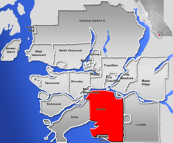
Surrey, British Columbia
| Surrey, British Columbia | |||
|
|||
 |
|||
| Country | Canada | ||
|---|---|---|---|
| Province | British Columbia | ||
| Regional District | Metro Vancouver | ||
| Incorporation | 1879 (municipality status) | ||
| 1993 (city status) | |||
| Government | |||
| - Mayor | Dianne Watts | ||
| - Governing body | |||
| - MLAs |
List of MLAs
|
||
| - MPs |
List of MPs
|
||
| - School Trustees |
List of Trustees
|
||
| Area | |||
| - Total | 317.4 km² (122.5 sq mi) | ||
| Elevation | 0-134 m (0-440 ft) | ||
| Population (2006)[1] | |||
| - Total | 437,685 (Ranked 12th ) | ||
| - Density | 1,095.9/km² (2,838.4/sq mi) | ||
| Time zone | PST (UTC-8) | ||
| - Summer (DST) | PDT (UTC-7) | ||
| Postal code span | V3R–V3X, V4A, V4N, V4P | ||
|
|
|||
| Website: City of Surrey - Homepage | |||
Surrey is a Canadian city in the province of British Columbia that lies within the Metro Vancouver district, and geographically at the centre of the larger region known as the Lower Mainland of BC. It is the province's second-largest city by population after the city of Vancouver.
The six "town centres" comprising the City of Surrey are: Fleetwood, Whalley/City Centre, Guildford, Newton, Cloverdale, and South Surrey. [2]
Contents |
History
Surrey was incorporated in 1879, and encompasses land formerly occupied by a number of Coast Salish-speaking aboriginal groups. When Englishman H.J. Brewer looked across the Fraser River from New Westminster and saw a land reminiscent of his native County of Surrey in England, the settlement of Surrey was placed on the map. The area then comprised forests of douglas-fir, fir, red cedar, hemlock, blackberry bushes, and cranberry bogs. A portion of present-day Whalley (named after Harry Whalley, who owned and operated a gas bar at the bend in King George Highway at 108th, "Whalley's Corner") was used as a burial ground by the Kwantlen (or Qw’ontl’en) Nation.
Settlers arrived first in Cloverdale and parts of South Surrey, mostly to farm, fish, harvest oysters, or set up small stores. Once the Pattullo Bridge was erected in 1937, the way was open for Surrey to expand. In the post-war fifties, North Surrey's neighbourhoods filled with single family homes and Surrey (not yet a city) became a true bedroom community, absorbing commuters who worked in Burnaby or Vancouver.
In the 1980s and 1990s Surrey witnessed unprecedented growth, as people from different parts of Canada and other parts of the world, particularly Asia, began to make the municipality their home. Surrey is projected to surpass the city of Vancouver as the most populous city in B.C. by 2020.
Government and politics
Surrey is governed by an eight-member city council. The current mayor of Surrey is Dianne Watts. The last elections were held in November 2005.
In the recent 2005 provincial elections, the New Democratic Party of British Columbia won four of Surrey's seats, all of them in the more urbanized north and centre of the city, while the BC Liberal Party won three seats in the more rural east and south.
In the Canadian House of Commons (2006 elections), the Conservative Party of Canada holds two of Surrey's four seats, while the remaining two were split by the Liberal Party of Canada and the New Democratic Party (NDP). The NDP won the Surrey North riding previously held by the late independent Chuck Cadman. In May 2005, Cadman drew national attention to himself and his riding by casting the one vote that saved Prime Minister Paul Martin's Liberal minority government in a motion of confidence. Cadman's political involvement began with his wish to see reforms enacted on the Young Offenders Act, following the 1992 stabbing death of his 16-year-old son, Jesse Cadman, by another 16-year-old.
Transportation
Transportation has played a major role in the historical development of Surrey.
The Semiahmoo Trail, which stretched from White Rock to North Surrey, was one of the first overland trails to bring settlers into the Fraser Valley. The first regular ferry service across the Fraser River started in 1882 on the steam ferry K de K with the point of departure at Brownsville. The ferry landed on the Surrey side at the start of the Old Yale Road, which connected directly inland to Yale, and was a major Gold Rush trail.
The Canadian National Railway, BNSF Railway, and Southern Railway of British Columbia systems are still active and stretch across Surrey to eastern provinces and southward into the United States.
The Fraser Surrey Docks on the Fraser River service more than 400 deep sea vessels annually and over 2 million tons of cargo from around the world pass through the terminal. It is the largest facility of its kind on the west coast of North America.
Limited public transport, provided by TransLink, connects some of Surrey's disparate centres to each other as well as to other Lower Mainland cities and municipalities. The Skytrain Expo Line provides 35-minute service to downtown Vancouver via four stations.
Vancouver International Airport, is 35 km (22 mi) from Surrey by road. Vancouver Airport offers direct daily service to Canada, North America, Europe, and Asia.
Demographics
As of 2001, the population of Surrey was approximately 340,825 (up from 304,477 in 1996), a 14.2% increase. In 2004, the City of Surrey estimated that the city's population officially reached approximately 400,000. Visible minorities account for 127,015 of Surrey's citizens. Surrey's immigrant population is around 184,000. According to the 2006 census, Surrey's population was 394,976 in June, 2006. [1]

Religious profile
- 25.8% No religious affiliation
- 19.2% Sikh
- 16.2% Roman Catholic
- 11.0% Protestant
- 6.4% Other Christian
- 2.9% Muslim
- 2.8% Hindu
- 1.9% Buddhist
- 1.5% Jewish
- 0.1% Coptic Orthodox (Egyptian) Christian [3]
- 0.1% Other Eastern Religion
- 0.2% Religion not mentioned above
- Source: Surrey Community Profile Statistics Canada. 2002. 2001 Community Profiles. Released June 27, 2002. Last modified: 2005-11-30. Statistics Canada Catalogue no. 93F0053XIE.
Events and sports
Every summer, Surrey hosts the Canada Cup International Women's Fastpitch Tournament. It began in 1993 as an international women's fastpitch developmental tournament to help teams prepare for the Olympics by facing top-calibre competition. The event continues to be a fan favourite with gate attendance reaching 93,000 for the 2004 nine-day tournament.
Every year on April 13, the Sikh community celebrates Vaisakhi during the April long weekend, which often includes a nagar kirtan, or parade. An estimated 100,000 people attended in 2008. [4]
The town centre of Cloverdale hosts the annual Cloverdale Rodeo and Country Fair at the Cloverdale Fairgrounds. Beginning in 1888, the event is Canada's second largest rodeo and features 150 acres (0.61 km2) of family-oriented entertainment including agricultural/horticultural exhibits, a western tradeshow, parade, community stages, and the Pacific Northwest Firefighter Combat Challenge.
The BCJHL Surrey Eagles hockey team plays at the South Surrey Arena in Surrey. The Eagles won the BCJHL championship, Fred Page Cup, in 1997, 1998 and 2005; the western championship, the Doyle Cup, in 1997 and 1998; and the national championship, the Royal Bank Cup, in 1998.
Surrey hosted the Canadian national qualifying tournament in 2006, and sends a local team to compete for a spot in the Little League World Series in Williamsport, Pennsylvania.
Surrey is home to Canada's first kabaddi-specific stadium. [5]
Every October, since 1991, Surrey has hosted the Surrey International Writers' Conference. This event brings established writers, agents, editors and publishers from all over the world to the Sheraton Vancouver Guildford Hotel.
The Surrey RCMP hold an annual basketball tournament with participation from all the city's Secondary Schools. The event is the city's largest annual sports tournament.
Education
Surrey is home to the Surrey Campus of Simon Fraser University. The Newton town centre of Surrey hosts the main campus of the Kwantlen Polytechnic University.
School District 36 Surrey oversees 99 public elementary and 21 public secondary schools. It is the largest school district in British Columbia. Private schools in Surrey include Holy Cross Regional High School, Pacific Academy and Southridge School. There are no public middle schools in Surrey, so an average elementary school goes from grades kindergarten through 7, and secondary school starts at grade 8 and continues through grade 12. There are 63,036 students enrolled in public and private schools.
Geography and climate
Surrey's motto, "The future lives here" is meant to reflect the balance between the future of a progressive and dynamic city balanced in harmony with green spaces, parks, and open areas characterized by Surrey’s rural landscape.[6] Its former motto, "City of Parks" was derived from 5,400 acres (22 km²) of passive and active park land, 15 golf courses and driving ranges, including the Northview Golf & Country Club, home to the former Air Canada Championship. The city is characterized by a low population density urban sprawl, typical of western North America, which includes areas of residential housing, light industry and commercial centres and is prone to strip development and malls. Approximately 35% of the land is designated as agricultural, but constant pressure for growth continues to erode the edges of what was once a largely rural landscape.
The climate is typically inter-coastal Pacific-Northwest; rainy, wet winters, often with heavy rainfall lasting into early spring, with mild, sunny summers and cool autumns.
Notable people from Surrey, B.C.
- Kalib Starnes, professional mixed martial artist
- Adam Loewen, baseball player; pitcher for the Baltimore Orioles
- John Tenta, professional wrestler known as Earthquake
- Jean Luc Bilodeau, actor
- Elise Estrada, singer
- Lisa Brokop, singer
- Britt Irvin, actress, singer - 2008 Leo Award Nominee
- Harbhajan Mann, Singer
- Daniel Igali, Freestyle Wrestler
- Jazzy B, Singer
Affiliated cities and municipalities
Surrey has two sister cities. As of April 20, 1989 Kōtō, Japan became the sister city of Surrey. Kōtō is one of the wards of Metropolitan Tokyo. The other is the Special Economic Zone of the City of Zhuhai, bordering The Special Administrative Region of Macau, China.
There are 21 municipalities in Metro Vancouver. While each of these has a separate municipal government, the Metro government oversees common services within the metropolitan area such as water, sewage, transportation, and regional parks.
 |
New Westminster | Coquitlam, Port Coquitlam, Pitt Meadows, Barnston Island | Maple Ridge |
|
|||
| Delta | Langley Township, Langley City | ||||||
| Boundary Bay, Point Roberts (Washington, USA) | White Rock, Blaine (Washington, USA) | Lynden (Washington, USA) |
References
- ↑ 2006 Community Profiles - Census Subdivision
- ↑ http://www.surrey.ca/Visiting+Surrey/About+Surrey/Surrey+Is.htm
- ↑ 2001 census (percentage out of 340,000 Surrey residents)
- ↑ "100,000 in Vaisakhi parade". Surrey Now. Retrieved on 2008-05-29.
- ↑ Government of British Columbia (2006-09-09). "Premier Officially Opens Surrey Kabaddi Stadium". Press release. Retrieved on 2008-01-12.
- ↑ http://www.surrey.ca/Inside+City+Hall/Your+Mayor+and+Council/Logo+and+Branding/default.htm
External links
- City of Surrey
- The City of Surrey - A History
- Surrey Public Library
- School District 36 Surrey
- Surrey Leader newspaper
- Canada Cup
- Softball City Home of the Canada Cup International Women's Fastpitch Tournament
- Surrey Eagles
- TalkSurrey.ca
|
||||||||||||||
|
|||||||||||||||||
|
|||||||||||