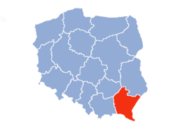
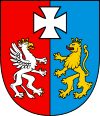
Subcarpathian Voivodeship
| Subcarpathian Voivodeship Województwo podkarpackie |
|||
| — Voivodeship — | |||
|
|||
 |
|||
 |
|||
| Coordinates(Rzeszów): | |||
| Country | |||
|---|---|---|---|
| Capital | Rzeszów | ||
| Counties |
4 cities, 21 land counties *
|
||
| Area | |||
| - Total | 17,844 km² (6,889.6 sq mi) | ||
| Population (2006) | |||
| - Total | 2,096,971 | ||
| - Density | 117.5/km² (304.4/sq mi) | ||
| - Urban | 850,022 | ||
| - Rural | 1,246,949 | ||
| Car plates | R | ||
| * further divided into 159 gminas | |||
| Website: http://www.wrota.podkarpackie.pl/pl/um | |||

Subcarpathian Voivodeship (also known as Podkarpacie Province, or by its Polish name of województwo podkarpackie [vɔjɛˈvut͡stfɔ pɔtkarˈpat͡skʲɛ] or simply Podkarpackie) is a voivodeship, or province, situated in the far south-east of Poland. Its administrative capital and largest city is Rzeszów (historically Lwów was the administrative centre of this part of Poland, but after 1945, when Lwów became part of the Soviet Union, its role was taken over by Rzeszów).
The voivodeship was created on January 1, 1999, out of the former Rzeszów, Przemyśl, Krosno and (partially) Tarnów and Tarnobrzeg Voivodeships, pursuant to the 1998 Local Government Reorganization Act. The name derives from the region's location close to the Carpathian Mountains.
It is bordered by Lesser Poland Voivodeship to the west, Świętokrzyskie Voivodeship to the north-west, Lublin Voivodeship to the north, Ukraine to the east and Slovakia to the south. It covers an area of 17,844 square kilometres (6,890 sq mi), and has a population of 2,096,971 (as at 2006).
Contents |
Cities and towns
The voivodeship contains 46 cities and towns. These are listed below in descending order of population (according to official figures as of 30 June 2008)[1]
|
1. Rzeszów (171,330) |
24. Nowa Sarzyna (6,178) |
Administrative division
Subcarpathian Voivodeship is divided into 25 counties (powiats): 4 city counties and 21 land counties. These are further divided into 159 gminas.
The counties are listed in the following table (ordering within categories is by decreasing population).
| English and Polish names |
Area | Population (2006) |
Seat | Other towns | Total gminas |
|
| km² | sq mi | |||||
| City counties | ||||||
| Rzeszów | 77 | 30 | 163,155 | 1 | ||
| Przemyśl | 44 | 17 | 66,715 | 1 | ||
| Tarnobrzeg | 86 | 33 | 50,033 | 1 | ||
| Krosno | 43 | 17 | 47,693 | 1 | ||
| Land counties | ||||||
| Rzeszów County powiat rzeszowski |
1,219 | 471 | 169,586 | Rzeszów * | Dynów, Boguchwała, Głogów Małopolski, Sokołów Małopolski, Tyczyn, Błażowa | 14 |
| Mielec County powiat mielecki |
880 | 340 | 133,148 | Mielec | Radomyśl Wielki | 10 |
| Dębica County powiat dębicki |
776 | 300 | 132,473 | Dębica | Pilzno | 7 |
| Jarosław County powiat jarosławski |
1,029 | 397 | 122,368 | Jarosław | Radymno | 11 |
| Jasło County powiat jasielski |
830 | 320 | 115,128 | Jasło | 10 | |
| Krosno County powiat krośnieński |
924 | 357 | 109,715 | Krosno * | Jedlicze, Rymanów, Dukla, Iwonicz Zdrój | 9 |
| Stalowa Wola County powiat stalowowolski |
833 | 322 | 109,170 | Stalowa Wola | 6 | |
| Sanok County powiat sanocki |
1,225 | 473 | 94,740 | Sanok | Zagórz | 8 |
| Przeworsk County powiat przeworski |
698 | 269 | 78,691 | Przeworsk | Kańczuga, Sieniawa | 9 |
| Łańcut County powiat łańcucki |
452 | 175 | 77,710 | Łańcut | 7 | |
| Ropczyce-Sędziszów County powiat ropczycko-sędziszowski |
549 | 212 | 71,220 | Ropczyce | Sędziszów Małopolski | 5 |
| Przemyśl County powiat przemyski |
1,214 | 469 | 70,882 | Przemyśl * | 10 | |
| Leżajsk County powiat leżajski |
583 | 225 | 69,235 | Leżajsk | Nowa Sarzyna | 5 |
| Nisko County powiat niżański |
786 | 303 | 67,042 | Nisko | Rudnik nad Sanem, Ulanów | 7 |
| Brzozów County powiat brzozowski |
540 | 210 | 65,254 | Brzozów | 6 | |
| Strzyżów County powiat strzyżowski |
503 | 194 | 61,938 | Strzyżów | 5 | |
| Kolbuszowa County powiat kolbuszowski |
774 | 299 | 61,399 | Kolbuszowa | 6 | |
| Lubaczów County powiat lubaczowski |
1,308 | 505 | 57,120 | Lubaczów | Oleszyce, Narol, Cieszanów | 8 |
| Tarnobrzeg County powiat tarnobrzeski |
520 | 200 | 53,730 | Tarnobrzeg * | Nowa Dęba, Baranów Sandomierski | 4 |
| Lesko County powiat leski |
835 | 322 | 26,613 | Lesko | 5 | |
| Bieszczady County powiat bieszczadzki |
1,138 | 439 | 22,213 | Ustrzyki Dolne | 3 | |
| * seat not part of the county | ||||||
Protected areas
Protected areas in Subcarpathian Voivodeship include two National Parks and 11 Landscape Parks. These are listed below.
- Bieszczady National Park (part of the East Carpathian Biosphere Reserve)
- Magura National Park (partly in Lesser Poland Voivodeship)
- Cisna-Wetlina Landscape Park
- Czarnorzeki-Strzyżów Landscape Park
- Jaśliska Landscape Park
- Janów Forests Landscape Park (partly in Lublin Voivodeship)
- Pasmo Brzanki Landscape Park (partly in Lesser Poland Voivodeship)
- Pogórze Przemyskie Landscape Park
- Puszcza Solska Landscape Park (partly in Lublin Voivodeship)
- San Valley Landscape Park
- Słonne Mountains Landscape Park
- South Roztocze Landscape Park (partly in Lublin Voivodeship)
History
Ethnic groups
- Poles
- Pogorzans
- Lemkos
- Ukrainians
Most popular surnames in the region
- Mazur: 9,530
- Nowak: 9,301
- Baran: 8,020
References
- "Central Statistical Office(GUS) - TERYT(National Register of Territorial Land Apportionment Journal)".
 (in Polish) (01.09.2008). Retrieved on 2008-10-23.
- ↑ "Central Statistical Office(GUS) - Polish Official Census 2008". (in Polish) (30.06.2008). Retrieved on 2008-10-23.
See also
- Second Polish Republic’s Lwów Voivodeship
External links
 Media related to Subcarpathian Voivodeship at Wikimedia Commons
- Subcarpathia photo gallery
- (Polish) Subcarpathian Voivodeship official website
- (Polish) Podkarpacki Urząd Wojewódzki Official website
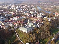
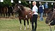
Subcarpathia landscape pictures
  |
  |
  |
  |
  |
  |
  |
  |
  |
  |
|
||||||||||
|
|||||||