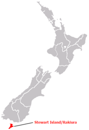
Stewart Island/Rakiura
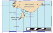 A map of the area around New Zealand's Stewart Island |
|
| Geography | |
|---|---|
 |
|
| Location | Foveaux Strait |
| Archipelago | New Zealand archipelago |
| Area | 1,746 km2 (674 sq mi) |
| Highest point | Mt. Anglem (979 m (3,210 ft)) |
| Country | |
| Regional Council | Southland |
| Largest city | Oban (322) |
| Demographics | |
| Population | 402 (as of 2006) |
| Density | 0.23 people/km2 |
| Ethnic groups | New Zealanders |
Stewart Island/Rakiura is the third-largest island of New Zealand. It lies 30 kilometres (19 mi) south of South Island, across Foveaux Strait. Its permanent population is slightly fewer than 400 people, most of whom live in the settlement of Oban.
Contents |
History and naming


Captain Cook was the first European to sight the island in 1770, but he thought it was part of the South Island so he named it South Cape. The island was named for William W. Stewart who was first officer on the ship Pegasus, which visited from Port Jackson (Sydney), Australia, in 1809 on a sealing expedition. Stewart charted the large south eastern harbour which now bears the ship's name (Port Pegasus), and determined the northern points of the island, proving that it was an island. He made three further visits to the island from the 1820s to the 1840s.[1] The original Maori name, Te Punga o Te Waka a Maui, positions Stewart Island/Rakiura firmly at the heart of Maori mythology. Translated as The Anchor Stone of Maui’s Canoe, it refers to the part played by the island in the legend of Maui and his crew, who from their canoe, the South Island, caught and raised the great fish, North Island.
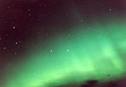
Rakiura is the more commonly known and used Maori name. It is usually translated as Glowing Skies, possibly a reference to the sunsets for which it is famous or for the Aurora Australis, the southern lights that are a phenomenon of southern latitudes.
For some, Rakiura is the abbreviated version of Te Rakiura a Te Rakitamau, translated as "great blush of Rakitamau", in reference to the latter's embarrassment when refused the hand in marriage of not one, but two daughters, of an island chief.[2] According to Maori legend, a chief on the island named Te Rakitamau was married to a young woman who became terminally ill and implored him to marry her cousin after she died. Te Rakitamau paddled across Te Moana Tapokopoko a Tawhiki (Foveaux Strait) to South Island where the cousin lived, only to discover she was recently married. He blushed with embarrassment so the island was called Te Ura o Te Rakitamau.
In 1841, the island was established as one of the three Provinces of New Zealand, and was named New Leinster. However, the province existed on paper only and was abolished after only five years, and with the passing of the New Zealand Constitution Act 1846 the province became part of New Munster, which entirely included South Island.[3] When New Munster was abolished in 1853, Stewart Island became part of Otago Province until 1861 when Southland Province split from Otago. In 1876 the provinces were abolished altogether.
Geography

The island has an area of 1,746 km². The north is dominated by the swampy valley of the Freshwater River. The river rises close to the northwestern coast and flows southeastwards into the large indentation of Paterson Inlet. The highest peak is Mt. Anglem, close to the northern coast, at a height of 979 metres (3,210 ft). It is one of the peaks in a rim of ridges that surround the Freshwater Valley.
The southern half is more uniformly undulating, rising to a ridge that runs south from the valley of the Rakeahua River, which also flows into Paterson Inlet. The southernmost point in this ridge is Mt. Allen, at 750 metres (2,500 ft). In the southeast the land is somewhat lower, and is drained by the valleys of the Toitoi River, Lords River, and Heron River. South West Cape on this island is the southernmost point of the main islands of New Zealand.
Mason Bay, on the west side, is notable as a long sandy beach on an island where beaches are typically far more rugged. One suggestion is that the bay was formed in the aftershock of a meteoric impact in the Tasman Sea.
Three large and numerous small islands lie around the coast. Notable among these are Ruapuke Island, in Foveaux Strait 32 kilometres (20 mi) northeast of Oban; Codfish Island, close to the northwest shore; and Big South Cape Island, off the southwestern tip. The Titi/ Muttonbird Islands group are between Stewart Island/ Rakiura and Ruapuke Island, around Big South Cape Island, and off the southeastern coast. Other islands of interest include Bench Island, Native Island, and Ulva Island, all close to the mouth of Paterson Inlet, and Pearl Island, Anchorage Island, and Noble Island, close to Port Pegasus in the southwest.
Two groups of tiny above-water rocks south of Stewart Island/Rakiura are geographically part of New Zealands: North Trap, a reef of above and below-water rocks at fronts the southern shore, about 28.2 kilometres (17.5 mi) southwest by south of the mouth of the Lords River. A 1.5 metres (4.9 ft) high rock near the western end and a 0.9 metres (3.0 ft) high rock near the eastern end give it the appearance of an overturned boat. South Trap, a reef of above-water rocks 1.2 metres (3.9 ft) to 1.8 metres (5.9 ft) high and below-water rocks at , lies about 16.9 kilometres (10.5 mi) south by west of North Trap.
Geo-magnetic anomaly
Owing to an anomaly in the magnetic latitude contours, this location is well placed for observing Aurora australis.
Settlements

The only town is Oban, on Half Moon Bay.
A previous settlement, Port Pegasus, once boasted several stores and a post office, and was located on the southern coast of the island. It is now uninhabited, and is accessible only by boat or by an arduous hike through the island. Another site of former settlement is at Port William, a four hour walk around the north coast from Oban, where immigrants from the Shetland Islands settled in the early 1870s. This was unsuccessful, and the settlers left within one to two years, most for sawmilling villages elsewhere on the island.
Stewart Island generates its own electricity via a diesel generator and so electric power is around five times more expensive than on the South Island.
Communications and economy
Fishing has been, historically, the most important element of the economy of Stewart Island, and while fishing is still important, tourism has taken over as the main source of income for islanders.
A regular passenger ferry service runs between Bluff and Oban.
There is an air link by Stewart Island Flights from Ryan's Creek Aerodrome to Invercargill Airport. Planes also land on the sand at Mason Bay, Doughboy Bay, and West Ruggedy Beach.
Although some forestry and farming takes place on Stewart Island/ Rakiura, the main business is fishing. Over 80% of the island is set aside as the Rakiura National Park, New Zealand's newest national park.
Government

In local government, Stewart Island is part of the Southland District. However, it shares with some other islands a certain relaxation in some of the rules governing commercial activities. For example, every transportation service operated solely on Great Barrier Island, the Chatham Islands, or Stewart Island/Rakiura is exempt from the Transport Act of 1962.
On 1 April, 2005, the TV3 (New Zealand) Campbell Live TV show reported that the New Zealand government planned to sell a large part of the island to the United States, to host an air base supporting its operations in Antarctica. In the following show, the announcer John Campbell said that staff members from the New Zealand Prime Minister's office had contacted them after receiving several complaints from the public about these plans. Campbell confirmed that the story was an April Fool's Day hoax.
From 1841 to 1853, Stewart Island was governed as New Leinster, then as part of New Munster. From 1853 onwards, it was part of the Otago Province.
Fauna
There are many species of birds on Stewart Island/ Rakiura that thrive because of the isolation and protection from predators. These include wekas, kākās, albatross, penguins, tokoekas, silvereyes, fantails, and kererus. The large colonies of Sooty Shearwaters, ( muttonbirds) on the offshore Muttonbird Islands, are subject to a sustainable harvesting program managed by Rakiura Maori.
Stewart Island/Rakiura supports a large population of white-tailed deer in coastal areas, which are hunted for meat and sport. There is also a small population of red deer confined to the inland areas.
Claims of Independence
The residents of Stewart Island have held a number of promotional fund-raising mock events regarding a Declaration of Independence for the island and to have it renamed by its original name of "RAKIURA".
In the late 1950s or even the early 1960s they had a local printer overprint “INDEPENDENT RAKIURA” on eight values of some earlier New Zealand postage and health stamps. There were also eight different values from 1d to £1 overprinted on these stamps and they also had their original values blotted out with small black circles. These were sold to collectors with the proceeds helping to refurbish the Rakiura Museum.
Also there was another fundraising effort to raise NZ$ 6000 for a new swimming pool for the island's school, by selling 50-cent passports for the newly "independent" island. There was even a mock ceremony featuring the new republic's flag and a Declaration of Independence on the 31st of July 1970.
Obviously these efforts were not serious attempts for independence as Stewart Island remains an integral part of New Zealand.[4]
References
- ↑ Foster, Bernard John. "Stewart, Captain William W.", An Encyclopaedia of New Zealand, 1966.
- ↑ "Rakiura Track - History". Department of Conservation. Retrieved on 2008-06-16.
- ↑ "New Leinster, New Munster, and New Ulster". Encyclopedia of New Zealand (1966).
- ↑ Stewart Island (New Zealand)