Staffordshire
| Staffordshire | |
|---|---|
 |
|
| Geography | |
| Status | Ceremonial & (smaller) Non-metropolitan county |
| Origin | Historic |
| Region | West Midlands |
| Area - Total - Admin. council - Admin. area |
Ranked 18th 2,713 km² (1,047 sq mi) Ranked 18th 2,620 km² (1,012 sq mi) |
| Admin HQ | Stafford |
| ISO 3166-2 | GB-STS |
| ONS code | 41 |
| NUTS 3 | UKG24 |
| Demography | |
| Population - Total (2007 est.) - Density - Admin. council - Admin. pop. |
Ranked 16th 1,064,800 392/km² (1,015/sq mi) Ranked 8th 816,700 |
| Ethnicity | 97.0% White 1.7% S.Asian |
| Politics | |
Staffordshire County Council http://www.staffordshire.gov.uk |
|
| Executive | Labour |
| Members of Parliament | |
| Districts | |
|
|
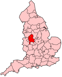
Staffordshire (pronounced /ˈstæfərdʃər/ or /ˈstæfərdʃɪər/; abbreviated Staffs) is a landlocked county in the West Midlands region of England. The county town is Stafford. Part of the National Forest lies within its borders. It adjoins the ceremonial counties of Cheshire, Derbyshire, Leicestershire, Warwickshire, West Midlands, Worcestershire, and Shropshire.
The largest city in ceremonial Staffordshire is Stoke-on-Trent. Lichfield also has city status, though only by the archaic definition (it has a cathedral), and is considerably smaller. The much larger Wolverhampton and Walsall were also in Staffordshire until local government reorganisation in 1974, but are now within the West Midlands. Major towns include Burton upon Trent, Newcastle-under-Lyme, Cannock, Tamworth, and Stafford itself.
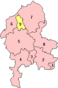
Staffordshire is divided into a number of districts. These are Cannock Chase, East Staffordshire, Lichfield, Newcastle-under-Lyme, South Staffordshire, the Borough of Stafford, Staffordshire Moorlands, and Tamworth. Stoke-on-Trent is administered as an independent unitary authority.
Contents |
History
Historically, Staffordshire was divided into the five hundreds of Cuttlestone, Offlow, Pirehill, Seisdon, and Totmonslow.
The historic boundaries of Staffordshire cover much of what is now the metropolitan county of West Midlands. An administrative county of Staffordshire was set up in 1889 under the Local Government Act 1888 covering the county except the county boroughs of Wolverhampton, Walsall, and West Bromwich in the south (the area known as the Black Country), and Hanley in the north. The Act also saw the towns of Tamworth (partly in Warwickshire) and Burton upon Trent (partly in Derbyshire) united entirely in Staffordshire.

Handsworth and Perry Barr became part of the county borough of Birmingham in the early 20th century, and thus associated with Warwickshire. Burton, in the east of the county, became a county borough in 1901, and was followed by Smethwick, another Black Country town in 1907. In 1910 the six towns of the Staffordshire Potteries, including Hanley, became the single county borough of Stoke-on-Trent.
A major reorganisation in the Black Country in 1966, under the recommendation of the Local Government Commission for England led to the creation of an area of contiguous county boroughs. The County Borough of Warley was formed by the merger of the county borough of Smethwick and municipal borough of Rowley Regis with the Worcestershire borough of Oldbury : the resulting county borough was associated with Worcestershire. Meanwhile, the county borough of Dudley, historically a detached part of Worcestershire, expanded and became associated with Staffordshire instead. This reorganisation led to the administrative county of Staffordshire having a thin protusion passing between the county boroughs (to the east) and Shropshire, to the west, to form a short border with Worcestershire.
Under the Local Government Act 1972, on April 1, 1974 the county boroughs of the Black Country and the Staffordshire urban district of Aldridge-Brownhills became, along with Birmingham, Solihull, and Coventry and other districts, a new metropolitan county of West Midlands. County boroughs were abolished, with Stoke becoming a non-metropolitan district in Staffordshire, and Burton forming an unparished area in the district of East Staffordshire. On April 1, 1997, under a recommendation of the Banham Commission, Stoke-on-Trent became a unitary authority independent of Staffordshire once more.
Economy
This is a chart of trend of regional gross value added of the non-metropolitan county of Staffordshire at current basic prices published (pp.240-253) by Office for National Statistics with figures in millions of British Pounds Sterling.
| Year | Regional Gross Value Added[1] | Agriculture[2] | Industry[3] | Services[4] |
|---|---|---|---|---|
| 1995 | 6,447 | 209 | 2,349 | 3,889 |
| 2000 | 8,621 | 150 | 2,986 | 5,485 |
| 2003 | 10,169 | 169 | 3,164 | 6,835 |
- ↑ Components may not sum to totals due to rounding
- ↑ includes hunting and forestry
- ↑ includes energy and construction
- ↑ includes financial intermediation services indirectly measured
The Britannia Building Society is based in Leek. JCB are based in Rocester near Uttoxeter. Alton Towers is nearby. Alstom has a factory in Stafford, with some (power transmission) being sold in 2003 to Areva.
Education
Staffordshire has a completely comprehensive system with eight independent schools. Most secondary schools are from 11-16 or 18, but two in Staffordshire Moorlands and South Staffordshire are from 13-18. Resources are shared, where appropriate, with Kingsmead Technology College, Blake High School and Norton Canes High School for example, combining their sixth forms to form a Sixth Form Consortium offering a greater selection of subjects than each individual school would otherwise be able to offer.
Two major universities are located in the county. Keele University is located in Newcastle-under-Lyme. Staffordshire University has two campuses; one located in Stoke-on-Trent, the other in Stafford.
Geography
In the north and in the south the county is hilly, with wild moorlands in the far north and Cannock Chase an area of natural beauty in the south. In the middle regions the surface is low and undulating. Throughout the entire county there are vast and important coal fields. In the southern part there are also rich iron ore deposits. The largest river is the Trent. The soil is chiefly clay and agriculture was not highly developed until the mechanisation of farms.

Staffordshire is also home to the highest village in Britain, Flash. The village in the Staffordshire Moorlands stands at 463 m (1518ft) above sea level. This record was confirmed in 2007 by the Ordnance Survey after Wanlockhead in Scotland also claimed the record. The BBC's 'The One Show' investigated the case in a bid to settle the argument and Flash turned out to be the highest.
Government
Staffordshire County Council is the local authority for the county.
Boundary changes
- 1844: The Counties (Detached Parts) Act transferred two parishes from, and part of a township to, the county.
- 1888: Those parts of the town of Tamworth lying in Warwickshire were ceded to Staffordshire.
- 1891: Harborne became part of the county borough of Birmingham and thus transferred from Staffordshire to Warwickshire by the Local Govt. Bd.'s Prov. Orders Conf. (No. 13) Act, 54 & 55 Vic. c. 161 (local act).
- 1895: a small section containing the villages of Shatterford and Upper Arley was transferred to Worcestershire.
- 1911: Handsworth became part of Birmingham, then in Warwickshire.
- 1928: Perry Barr was ceded to Warwickshire, also as part of Birmingham.
- 1966: Smethwick and Rowley Regis became part of Worcestershire, as components of the newly-formed borough of Warley. Dudley was ceded from Worcestershire, having absorbed the Staffordshire towns of Sedgley, Coseley and Brierley Hill into its local authority.
- 1974: Under The Local Government Act 1972, Dudley, Wolverhampton, Walsall and West Bromwich (plus Warley and Birmingham) became part of the newly-formed West Midlands County.
- 1994: The western/southern shores of Chasewater, were acquired from the West Midlands, transferring from the Walsall local authority into Lichfield District Council.
Towns and villages
See the list of places in Staffordshire and the List of civil parishes in Staffordshire
Dogs
A type of bull terrier called the Staffordshire Bull Terrier was bred for hunting purposes in this county. They are known affectionately as "Staffs", "Staffies", and "Nanny-dogs". Staffies should not be confused with the considerably larger American Staffordshire Terrier, American Pit Bull Terrier, and (English) Bull Terrier.
Transport
Canals
Staffordshire has an extensive network of canals including the Birmingham and Fazeley Canal, Caldon Canal, Coventry Canal, Shropshire Union Canal and Trent and Mersey Canal.
Railways
See Rail transport in Staffordshire
Roads
The county has relatively good links to the national roads network. Several major roads intersect the county, making it a popular location for commuters working in Birmingham.
The M42 has a junction in Tamworth at the south-east of the county, and heads south-west towards Birmingham. The M6 runs north through the county and junctions 10A-16 are in the county. The M6 Toll, the UK's first toll motorway, runs through the county with junctions in Weeford near Lichfield, Cannock and joins the M6 heading north towards Stafford.
The A5 and A34 run through the county. The former has been significantly widened to a dual carriageway at several sections, although much of it remains single carriageway.
Places of interest
|
|
|
||||||||||||||||||||||||||
See also
- Samuel Hieronymus Grimm
- The Stafford knot - as on the coat of arms above
- Tamworth Pig
External links
- East Staffordshire Community Website
- BBC Staffordshire website
- Staffordshire County Council
- Staffordshire Past Track - Historical archive about the county
- The story of a Staffordshire Home Guard Battalion, 1940-1944
- Staffordshire Photographs
- Staffordshire Tourism website
- The Staffordshire Encyclopaedia
|
|||||||||||
|
||||||||
|
|||||