St. Peter Port
| Island | Guernsey, Channel Islands |
| Area | 2.5 sq mi (6.5 km²) |
| Population | 16,488 |
| - density | 6595.2 sq mi (2536.6/km²) |
| Electoral district | Divided into St. Peter Port North and St. Peter Port South |

St. Peter Port is the capital of Guernsey, as well as the main port of the island. Population was 16,488 in 2001. In Guernesiais and in French, historically the official language of Guernsey, the name of the town and its surrounding parish is St Pierre Port. The "port" distinguishes this parish from Saint Pierre Du Bois.
As well as being a parish, St. Peter Port is a small town consisting mostly of steep narrow streets and steps on the overlooking slopes.
The post code for addresses in this parish starts with GY1.
People from St. Peter Port, were nicknamed "les Villais" (the townspeople) or "cllichards" in Guernésiais.
Contents |
Geography
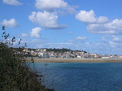
St. Peter Port is located on the East coast of Guernsey. It borders St Sampson's in the North, The Vale in the North-West, St Andrew's in the West and St Martin's in the South.
Relief
The land in the North and by the harbour is low lying but in the South, the land gets much higher (but not as high as St Martin's or the Forest). This means that there are quite a few cliffs on the coast between Havelet and Fermain.
Features
The features of the town include:
- The Royal Court House, seat of the Bailiwick's government
- Hauteville House, Victor Hugo's house of exile (now a museum run by the city of Paris)
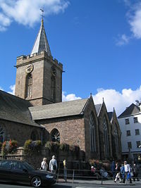
- The Town Church, the parish church of St Peter Port at the heart of the town
- St Peter Port Harbour
- Castle Cornet, the historic fortress that guarded the strategic entrance to the port. The castle was formerly a tidal island but it is now joined by a breakwater to the enlarged harbour.
- Elizabeth College founded in 1563 by Elizabeth I of England. The main building (built 1826) is a prominent feature of the skyline.
- The market, the Arcade, the High Street and the Pollet, which are all part of the shopping district
- The Guernsey Aquarium, situated in fortified tunnels built by the Nazi's during the German Occupation.
Main roads
The following main roads (listed from North-South) provide important links between St Peter Port and the other parishes:
- Les Banques (leads up the coast to St Sampson's and the North of the Island)
- Rue Des Varendes (leads to the parish of Castel)
- Mount Row (leads to St Andrew's and the West of the Island)
- Ruette Brayes (leads to St Martin's and the South of the Island)
- Fort Road (leads to St Martin's)
The following coastal roads (listed from North-South) are also very important as they provide access to the shops, carparks and the harbour:
- St George's Esplanade
- North Esplanade
- South Esplanade
- Mount Durand
Car parks
The following are major car parks of St.Peter Port, listed from north to south:
- Salarie Corner
- North Beach
- Crown Pier
- Albert Pier
- Model Yacht Pond
|
|||||
|
|||||||||