St. Charles County, Missouri
| Saint Charles County, Missouri | |
| Map | |
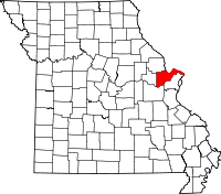
 Location in the state of Missouri |
|
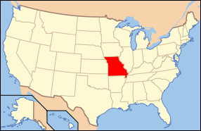
 Missouri's location in the U.S. |
|
| Statistics | |
| Founded | 1812 |
|---|---|
| Seat | Saint Charles |
| Area - Total - Land - Water |
592 sq mi (1,533 km²) 560 sq mi (1,450 km²) 32 sq mi (83 km²), 5.39% |
| Population - (2006) - Density |
338,719 605/sq mi (233.6/km²) |
| Website: www.sccmo.org | |
St. Charles County is a county located in the U.S. state of Missouri. As of 2000, the population was 283,883. Saint Charles County is part of the St. Louis Metro Area. Its county seat is Saint Charles[1]. The county was organized in 1812 and named for the Italian cardinal Saint Charles Borromeo.[2]
St. Charles County is one of the fastest growing counties in the nation, with a population of 338,719 in 2006. It also includes an important area of vineyards and wineries whose distinction has been recognized. On its rural outer edge along the south-facing bluffs above the Missouri River is an area of numerous wineries, so that SH 94 is sometimes called the Missouri Weinstrasse. The area includes the Augusta AVA, designated in 1980 as the first American Viticultural Area by the federal government.
Contents |
Geography
The county has a total area of 592 square miles (1,534 km²), of which, 560 square miles (1,451 km²) of it is land and 32 square miles (83 km²) of it (5.39%) is water.
Adjacent counties
- Lincoln County (northwest)
- Calhoun County, Illinois (north)
- Jersey County, Illinois (northeast)
- Madison County, Illinois (east)
- St. Louis County (southeast)
- Franklin County (south)
- Warren County (west)
Major highways
- Interstate 64
- Interstate 70
- U.S. Route 40
- U.S. Route 61
- U.S. Route 67
- Route 79
- Route 94
- Route 364
- Route 370
Major Municipalities
- St. Charles - 68,000 est.
- St. Peters - 66,000 est.
- O'Fallon - 74,000 est.
- Lake St. Louis - 14,000 est.
- Wentzville - 23,000 est.
Demographics
As of 2000, there were 283,883 people, 101,663 households, and 77,060 families residing in the county. The population density was 507 people per square mile (196/km²). There were 105,514 housing units at an average density of 73 persons/km² (188 persons/sq mi). The racial makeup of the county was 94.67% White, 2.69% African American, 0.23% Native American, 0.85% Asian, 0.03% Pacific Islander, 0.46% from other races, and 1.07% from two or more races. Hispanic or Latino of any race were 1.47% of the population.
There were 101,663 households out of which 40.50% had children under the age of 18 living with them, 63.20% were married couples living together, 9.20% have a woman whose husband does not live with her, and 24.20% were non-families. 19.40% of all households were made up of individuals and 5.90% had someone living alone who was 65 years of age or older. The average household size was 2.76 and the average family size was 3.18.
In the county the population was spread out with 29.00% under the age of 18, 8.20% from 18 to 24, 32.60% from 25 to 44, 21.60% from 45 to 64, and 8.80% who were 65 years of age or older. The median age was 34 years. For every 100 females there were 97.10 males. For every 100 females age 18 and over, there were 94.10 males.
The median income for a household in the county was $57,258, and the median income for a family was $64,415. Males had a median income of $44,528 versus $29,405 for females. The per capita income for the county was $23,592. 4.00% of the population and 2.80% of families were below the poverty line. Out of the total people living in poverty, 4.90% are under the age of 18 and 5.10% are 65 or older.
St. Charles County, with a population of 338,719, has been one of the fastest-growing counties in the country for decades, with 55 percent growth in the 1980s, 33 percent in the 1990s, and another 13 percent between 2000 and 2004. The county features a cross-section of industry, as well as extensive retail and some agriculture. With the Missouri River on the south and the Mississippi on the north and east, the county is bisected east to west by Interstate 70. St. Charles County has two small airports and two ferries that cross the Mississippi River. The City of St. Charles is the county seat.
Cities and Towns
St. Charles County has 21 municipalities:
|
|
|
|
|
References
- ↑ "Find a County". National Association of Counties. Retrieved on 2008-01-31.
- ↑ "Missouri History – County Origins". www.sos.mo.gov. Missouri Secretary of State. Retrieved on 2008-09-05.
External links
- St. Charles County Government Website
- St. Charles Chamber of Commerce
- St. Charles City-County Library District
|
|||||||||||||||||||||||
|
||||||||||||||||||||||||||
|
