Shropshire
| Shropshire | |
|---|---|
| Motto of County Council: "Floreat Salopia" ("May Shropshire flourish") | |
 |
|
| Geography | |
| Status | Ceremonial & (smaller) Non-metropolitan county |
| Origin | Historic |
| Region | West Midlands |
| Area - Total - Admin. council - Admin. area |
Ranked 13th 3,487 km² (1,346 sq mi) Ranked 14th 3,197 km² (1,234 sq mi) |
| Admin HQ | Shrewsbury |
| ISO 3166-2 | GB-SHR |
| ONS code | 39 |
| NUTS 3 | UKG22 |
| Demography | |
| Population - Total (2007 est.) - Density - Admin. council - Admin. pop. |
Ranked 42nd 452,600 130/km² (337/sq mi) Ranked 34th 289,100 |
| Ethnicity | 97.3% White 1.2% S.Asian |
| Politics | |
 Shropshire County Council http://www.shropshire.gov.uk |
|
| Executive | Conservative |
| Members of Parliament | |
| Districts | |
|
|
Shropshire (pronounced /ˈʃrɒpʃər/ or /ˈʃrɒpʃɪər/), alternatively known as Salop[6] or abbreviated, in print only, Shrops,[7] is a county in the West Midlands region of England. It borders Wales to the west. Shropshire is one of England's most rural and sparsely populated counties,[8] with the population of the non-metropolitan/shire county 289,100 - making it the least populated two-tier governed area in the United Kingdom. The shire county and its districts will be replaced with a unitary authority on 1 April 2009. The borough of Telford and Wrekin, included in Shropshire for ceremonial purposes, has been a unitary authority since 1998.[9]
The county town is Shrewsbury, which is culturally and historically important,[10] although Telford, which was constructed around a number of older towns, most notably Wellington, Dawley and Madeley, is today the most populous.[11] Other notable towns are Oswestry in the north-west, Bridgnorth in the south-east and Ludlow to the south. The Ironbridge Gorge area is advertised as the 'Birthplace of Industry'[12], and is a UNESCO World Heritage Site, covering Ironbridge, Coalbrookdale and a part of Madeley.[13] There are additionally other notable historic industrial sites located around the county such as Broseley, Snailbeach and Highley as well as the Shropshire Union Canal.[14]
The Shropshire Hills Area of Outstanding Natural Beauty covers about a quarter of the county, mainly in the south.[15] The Wrekin is one of the most famous natural landmarks in the county,[16] though the highest hills are the Clee Hills,[17] Stiperstones[18] and the Long Mynd.[19] Wenlock Edge is another significant geographical and geological landmark,[20] and the River Severn, Great Britain's longest river, runs through the county, exiting into Worcestershire via the Severn Valley. Shropshire is landlocked, and with an area of 1,346 square miles (3,490 km2), is England's largest inland county.[21]
Contents |
History
The area now considered Shropshire was for a long time considered within Wales and was the eastern part of the Kingdom of Powys; known in Welsh poetry as the Paradise of Powys. It was annexed to Mercia by King Offa in the eighth century, at which time he built two significant dykes there to defend his territory against the Welsh or at least demarcate it. In subsequent centuries, the area suffered repeated Danish invasion, and fortresses were built at Bridgnorth and Chirbury.[22]
After the Norman Conquest in 1066, major estates in Shropshire were granted to Normans, including Roger de Montgomerie, who ordered significant constructions, particularly in Shrewsbury, the town of which he was Earl.[23] Many defensive castles were built at this time across the county to defend against the Welsh and enable effective control of the region, including Ludlow Castle[24] and Shrewsbury Castle.[25] The western frontier with Wales was not finally determined until the 14th Century. Also in this period, a number of religious foundations were formed, the county largely falling at this time under the diocese of Hereford and that of Coventry and Lichfield. Some areas in later times fell under the diocese of St. Asaph until it ceased to exist in 1920.
The county was a central part of the Welsh Marches during the medieval period and was often embroiled in the power struggles between powerful Marcher Lords, the Earls of March and successive monarchs.[26]
The county also contains a number of historically significant towns, including Shrewsbury, Ludlow and Oswestry. Additionally, the area around Coalbrookdale in the county is seen as highly significant, as it is regarded as one of the birthplaces of the Industrial Revolution. The village of Edgmond, near Newport, is the location of the lowest recorded temperature (in terms of weather) in England and Wales.[27]

Etymology
Salop is an old abbreviation for Shropshire, once used on envelopes or telegrams, and comes from the Anglo-French 'Salopesberia'. It has now been replaced by the more contemporary 'Shrops' although Shropshire residents are still referred to as 'Salopians'. [6]
When a county council for the county was first established in 1888, it was called Salop County Council. [28] Following the Local Government Act 1972, Salop became the official name of the county for ceremonial purposes. The name was unpopular, and a campaign, led by local councillor John Kenyon, succeeded in renaming both the county and council to Shropshire in 1980. [29]
County extent
The border with Wales was defined in the 16th century - the hundreds of Oswestry (including Oswestry) and Pimhill (including Wem), and part of Chirbury had prior to the Laws in Wales Act formed various Lordships in the Welsh Marches.
The present day ceremonial county boundary is almost the same as the historic one. Notably there has been the removal of several exclaves and enclaves. The largest of the exclaves was Halesowen, which became part of Worcestershire in 1844 (now part of the West Midlands county), and the largest of the enclaves was Herefordshire's Farlow in South Shropshire, also transferred in 1844, to Shropshire. Alterations have been made on Shropshire's border with all neighbouring English counties over the centuries. Gains have been made to the south of Ludlow (from Herefordshire), to the north of Shifnal (from Staffordshire) and to the north (from Cheshire) and south (from Staffordshire) of Market Drayton. The county has lost land in two places - to Staffordshire and Worcestershire.[30]
Geography
Geographically, Shropshire is divisible into two distinct halves - North and South. The county has a highly diverse geology.
North Shropshire


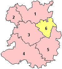
Politically, North Shropshire is composed of Oswestry district, North Shropshire district, Shrewsbury and Atcham borough and the borough of Telford and Wrekin.
The North Shropshire Plain is an extension of the flat and fertile Cheshire Plain. It is here that most of the county's large towns, and population in general, are to be found. Shrewsbury at the centre, Oswestry to the north west, Whitchurch to the north, Market Drayton to the north east and Newport and the Telford conurbation (Telford, Wellington, Oakengates, Donnington and Shifnal) to the east. The land is fertile and agriculture remains a major feature of the landscape and the economy. The River Severn runs through the lower half of this area (from Wales in the west, eastwards), through Shrewsbury and down the Ironbridge Gorge, before heading south to Bridgnorth.
The area around Oswestry has more rugged geography than the North Shropshire Plain and the western half is over an extension of the Wrexham Coalfield and there are also copper deposits on the border with Wales. Mining of stone and sand aggregates is still going on in Mid-Shropshire, notably on Haughmond Hill, near Bayston Hill and around the village of Condover. Lead mining also took place at Snailbeach and the Stiperstones, but this has now ceased. Other primary industries, such as forestry and fishing, are to be found too.
The A5 and M54 run from Wolverhampton (to the east of the county) across to Telford, around Shrewsbury parallel to the line of Watling Street an ancient trackway. The A5 then turns north west to Oswestry, before heading north into Wales in the Wrexham area. This is an important artery and the corridor is where most of Shropshire's modern commerce and industry is found, notably in Telford new town. There are also a number of railway lines crossing over the area, which centre at Shrewsbury. To the south west of Telford, near the Ironbridge Gorge, is Ironbridge Power Station.
The new town of Telford is built partly on a former industrial area centred on the East Shropshire Coalfield as well as on former agricultural land. There are still many ex-colliery sites to be found in the area, as well as disused mine shafts. This industrial heritage is an important tourist attraction, as is seen by the growth of museums in the Ironbridge, Coalbrookdale and Jackfield area. Blists Hill museum and historical (Victorian era) village is a major tourist attraction as well as the Iron Bridge itself. In addition, Telford Steam Railway runs from Horsehay.
South Shropshire
- For information specifically on the Area of Outstanding Natural Beauty, see Shropshire Hills AONB.
Politically, the area is composed of South Shropshire district and Bridgnorth district.

South Shropshire is more rural, with fewer settlements and no large towns, and its landscape differs greatly from that of North Shropshire. The area is dominated by significant hill ranges and river valleys, woods, pine forests and 'batches', a colloquial term for small valleys and other natural features. Farming is more pastoral than the arable found in the north of the county. The only substantial towns are Ludlow, with a population of around 10,000 people, Bridgnorth and Church Stretton. The Shropshire Hills AONB is located in the south-west, covering an area of 804 km2 (310 sq mi); it forms the only specifically protected area of the county. Inside this area is the popular Long Mynd, a large plateau of 536 m (1,760 ft) Stiperstones and 516 metres (1,690 ft) high to the East of the Long Mynd, overlooking Church Stretton.
The A49 is the main road through the area, running north to south, from Shrewsbury to Herefordshire. A railway line runs through the area on the same route as the A49 with stations at Church Stretton, Craven Arms and Ludlow. The steam heritage Severn Valley Railway runs from Bridgnorth into Worcestershire along the Severn Valley.
Because of its valley location and character, Church Stretton is sometimes referred to as Little Switzerland. Nearby are the old mining and quarrying communities on the Clee Hills, notable geological features in the Onny Valley and Wenlock Edge and fertile farmland in the Corve Dale. The River Teme drains this part of the county, before flowing into Worcestershire to the South and joining the River Severn.
One of the Clee Hills, the Brown Clee Hill, is the county's highest peak at 546 m (1,790 ft).
South West Shropshire is a little known and remote part of the county, with Clun Forest, Offa's Dyke, the River Clun and the River Onny. The small towns of Clun and Bishop's Castle are in this area. The countryside here is very rural and is in parts wild and forested. To the south of Clun is the Welsh town of Knighton.
Climate
The climate of Shropshire is generally moderate. Rainfall averages 760 to 1,000 mm (30 to 40 in), influenced by being in the rainshadow of the Cambrian Mountains from warm, moist frontal systems of the Atlantic Ocean which bring generally light precipitation in Autumn and Spring. [31] The hilly areas in the south and west are much colder in the winter, due to their high elevation, they share a similar climate to that of the Welsh Marches and Mid-Wales. The flat northern plain in the north and east has a similar climate to that of the rest of the West Midlands.
The only weather station in the county is located at Shawbury, which is in the north, between Shrewsbury and Market Drayton.
|
||||||||||||||||||||||||||||||||||||||||||||||||||||||||||||||||||||||||||||||||||||||||||||||||||
Politics


Shropshire has five constituencies, four of which returned Conservative MPs at the 2005 general election and one, Telford, returned a Labour MP. This is a marked change from the 2001 general election result, where the county returned only one Conservative, three Labour and a Liberal Democrat to the Commons (see maps to the right).
The current MPs of Shropshire are:
- David Wright, Labour, Telford (covering the town of Telford)
- Owen Paterson, Conservative, North Shropshire (covering the North Shropshire district and Oswestry borough)
- Philip Dunne, Conservative, Ludlow (covering the South Shropshire and (the majority of) Bridgnorth districts)
- Daniel Kawczynski, Conservative, Shrewsbury and Atcham (covering the borough of Shrewsbury and Atcham)
- Mark Pritchard, Conservative, The Wrekin (covering Telford and Wrekin borough, minus Telford, and including a small area of Bridgnorth district)
In 2005 there was also a County Council election in which the Conservatives gained overall control of the shire county. Telford and Wrekin Borough Council remained at the time under Labour control but has since gone to no-overall control, with a Conservative executive. Being a rural county, there are a number of independent councillors on the various councils in the county.[32]
The Conservatives gained complete control of Shrewsbury and Atcham Borough Council in the May 2006 local elections.
Divisions and environs
The area under the control of the county council, or shire county, is divided into five non-metropolitan districts. They are North Shropshire, Oswestry, Shrewsbury and Atcham, South Shropshire and Bridgnorth.[33] Telford and Wrekin is a unitary authority which forms part of the county for various functions such as Lord Lieutenant but does not come under county council control. Oswestry, Shrewsbury & Atcham and Telford & Wrekin have the status of boroughs. The county including Telford and Wrekin, the ceremonial county, borders Cheshire, Staffordshire, Worcestershire, Herefordshire, and the Welsh preserved counties of Powys and Clwyd.
|
Local government reform
see also: 2009 structural changes to local government in England and Shropshire Council

In 2006 a local government white paper supported proposals for new unitary authorities to be set up in England in certain areas. Existing non-metropolitan counties with small populations, such as Cornwall, Northumberland and Shropshire, are favoured by the government to be covered by unitary authorities in one form or another (the county can either become a single unitary authority, or be broken into a number of unitary authorities). Existing unitary authority areas within these counties' ceremonial boundaries (such as Telford and Wrekin) will not be affected and there will be no boundary changes.
Shropshire County Council, supported by South Shropshire District Council and Oswestry Borough Council, proposed to the government that the non-metropolitan county of Shropshire become a single unitary authority (i.e. the district/borough councils would be abolished). This was opposed by the other 3 districts in the county and rejected overwhelmingly by residents in 3 separate parish referenda. The process would be similar to that of the Isle of Wight in the early 1990s, when its districts were abolished, leaving a unitary county authority. The ceremonial county of Shropshire would therefore consist of two unitary authority areas - Telford & Wrekin and Shropshire. The new unitary authority of Shropshire would be one of the largest in England in terms of area.
There has been political opposition to the proposals, on the grounds of loss of local democracy and abolishing councils rated as "excellent" or "good", chiefly from Shrewsbury and Atcham Borough Council. The proponents, however, feel that the move will save funds and allow the area to gain more regional prominence.[34]
The proposal to create a Shropshire unitary authority, covering the area of the existing non-metropolitan county, is supported by the DCLG and 1 April 2009 has been set as the date for the re-organisation to take place. The districts and their councils will be abolished and the county council will become (as the "continuing authority") the new unitary authority. Elections to the new authority's council will not take place however until May or June 2009.[35]
Part of the proposals include parishing and establishing a town council for Shrewsbury. The parish was created on 13 May 2008 and is the second most populous civil parish in England (only Weston-super-Mare has a greater population) with a population of over 70,000.
Transport
- See also: Railways of Shropshire

Shropshire is connected to the rest of the United Kingdom via a number of road and rail links. Historically, rivers in the county and the Shropshire Union Canal were used for transport also, although their use in transport is now significantly reduced. The county's main transportation hub is Shrewsbury, through which many significant roads and railways pass and join.
Major roads in the county include the M54 motorway, which connects Shropshire to the rest of the motorway network, and more specifically to the West Midlands county. The A5 also runs through the county, in an east-west direction. The road formerly ran through Shrewsbury, although a large dual-carriageway bypass has since been built. Other major trunk roads in the county include the north-south A49, the A53 and the A41.
There are a number of major railway lines running through the county, including the Welsh Marches Line, the Cambrian Line, the Heart of Wales Line and the Wolverhampton to Shrewsbury Line. The two train operating companies working in the county are London Midland and Arriva Trains Wales. A new company, Wrexham & Shropshire, commenced services from Shropshire to London Marylebone station, in spring 2008.
Shropshire is also the home of two major water supply aqueducts, the Elan aqueduct running through South Shropshire carrying water from Elan Valley to Birmingham and the Vyrnwy Aqueduct running through North Shropshire delivering water from Lake Vyrnwy to Liverpool.
Towns and villages
- Further information: List of places in Shropshire, Category:Towns in Shropshire, and Category:Villages in Shropshire
Shropshire has no cities, but 22 towns, of which 2 can be considered major. Telford is the largest town in the county with a population of 138,241 (which is approximately 30% of the total Salopian populace); whereas the county town of Shrewsbury has a lower, but still sizeable population of 70,560 (15%). The other sizeable towns are Oswestry, Bridgnorth, Newport and Ludlow. The historic town of Wellington now forms part of the Telford conurbation. The majority of the other settlements can be classed as villages or small towns. The larger settlements are primarily concentrated in a central belt that roughly follows the A5/M54 roadway. Other settlements are concentrated on rivers, Or crossings through the marshes that covered parts of Shropshire e.g. Ironbridge on the Severn, as these waterways were historically vital to trade.[36]
|
Telford and Wrekin shown within 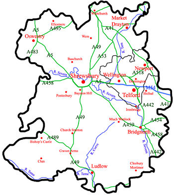 |
Towns (by population): Telford (138,241)[37] |


|


|
Economy


The economy of Shropshire was traditionally dominated by agriculture.[38] However, in more recent years it has become more service orientated. The county town of Shrewsbury, the historic castle-dominated Ludlow and the industrial birthplace of Ironbridge Gorge are the foremost tourist areas in Shropshire,[39] along with the reclaimed canal network which provides canal barge holidays on the Shropshire Union Canal and linked canal networks in the region, although the natural beauty of the county draws people to all areas.
Industry is mostly found in Telford, Oswestry, Whitchurch, Market Drayton and Shrewsbury, though small industrial estates can be found in other, rural towns such as Church Stretton and Newport. Shrewsbury is becoming a centre for distribution and warehousing, as it is located on a nodal point of the regional road network.[40] In Telford, a new rail freight facility is being built at Donnington.
Telford and Shrewsbury are the county's two main retail centres, with contrasting styles of shopping - Shrewsbury's largely historic streets and Telford's large modern mall, Telford Shopping Centre.[41] Shrewsbury also has two medium-sized shopping centres, the indoor 'Pride Hill' and 'Darwin' centres (both located on Pride Hill),[42] and a smaller, partially covered, 'Riverside Mall'. Shrewsbury's situation of being the nearest substantial town for those in a large area of mid-Wales helps it draw in considerable numbers of shoppers, notably on Saturday.
Well-known companies in Shropshire include Müller Dairy (UK) Ltd in Market Drayton.[43] The RAF have two bases at RAF Cosford and RAF Shawbury,[44] and the charity PDSA has its head office in Priorslee, Telford.[45]
Statistics
Below is the chart of regional gross value added for the non-metropolitan county (that is, excluding Telford & Wrekin) of Shropshire at current basic prices published (pp.240-253) by Office for National Statistics with figures in millions of British pounds sterling.
| Year | Regional Gross Value Added[46] | Agriculture[47] | Industry[48] | Services[49] |
|---|---|---|---|---|
| 1995 | 2,388 | 238 | 618 | 1,533 |
| 2000 | 2,977 | 177 | 739 | 2,061 |
| 2003 | 3,577 | 197 | 843 | 2,538 |
With the statistics for the borough of Telford and Wrekin included, the following represents the ceremonial county:
| Year | Regional Gross Value Added[46] | Agriculture[47] | Industry[48] | Services[49] |
|---|---|---|---|---|
| 1995 | 4,151 | 266 | 1,483 | 2,403 |
| 2000 | 5,049 | 197 | 1,512 | 3,340 |
| 2003 | 5,947 | 218 | 1,693 | 4,038 |
Education
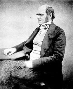
Shropshire has a completely comprehensive education system, with thirteen independent schools, including the prestigious Shrewsbury School, which the famed Charles Darwin attended. In the ceremonial county, the Telford and Wrekin borough has two selective schools and two independent schools. Newport Girls' High School and Adams' Grammar School, are both located in Newport. Thomas Telford School in Telford is also a notable school and is one of the best comprehensive schools in England.[50]
There are also two universities in Shropshire, the Telford campus of Wolverhampton University and in Edgmond, near Newport, Harper Adams University College, which offers mostly agricultural-based degrees.
Shropshire has the highest educational attainment in the West Midlands region.[51]
|
|||||||||||||||||||||||
Places of interest
|
|
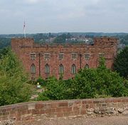
Shrewsbury Castle

Attingham Park Mansion
|
Famous people

- Robert Clive "Clive of India"
- Rowland Hill, 1st Viscount Hill, Napoleonic era general
- Lords and Ladies Craven (of Stokesay Castle)
- Abraham Darby early industrialist
- Charles Darwin eminent naturalist
- K. K. Downing, guitarist with Judas Priest
- William Farr epidemiologist and early bio-statistician
- Chris Hawkins (of Loppington), radio presenter, DJ, and celebrity
- George Jeffreys of Wem, (infamous judge)
- Adrian Jones, sculptor of the Quadriga at Hyde Park Corner
- Stephen Marchant, ornithologist
- Len Murray, (former head of the T.U.C)
- Mirabel Osler, author
- Wilfred Owen leading First World War poet
- Edith Pargeter (1913-1995), author
- Edmund Plowden (1518-1585)—legal scholar and theorist
- Sir Edmund Plowden (1590-1659)—Proprietor, Earl Palatine and Governor of New Albion
- Barbara Pym novellist
- Isobel Cooper (Izzy) famous opera singer from Much Wenlock
- T'Pau, 1980s pop group
- Sir Philip Sidney prominent Elizabethan
- Mary Webb (1881-1927), author
- Matthew Webb, (first man to swim the English Channel)
- Billy Wright, Captain of Wolves and England
- Humphrey Kynaston (1474-1534) - highwayman
- John Mytton 'Mad Jack' Mytton, Regency rake, MP, gambler and horseman.
- William Wycherley Restoration dramatist and playwright famous for The Country Wife
- Roy Wood, of Wem, in the band Wizard
Cultural references
Shropshire has been depicted and mentioned in a number of works of literature. The poet A. E. Housman used Shropshire as the setting for many of the poems in his first book, A Shropshire Lad, and many of Malcolm Saville's children's books are set in Shropshire. Additionally, D. H. Lawrence's novella, St. Mawr, is partially set in the Longmynd area of South Shropshire.
In Susanna Clarke's Jonathan Strange & Mr Norrell, Jonathan Strange is from the county, and some parts of the book are set there. Another fictional character from Shropshire is Mr Grindley, from Charles Dickens' Bleak House. P. G. Wodehouse's fictional Blandings Castle, the ancestral home of Clarence, the ninth Earl of Emsworth, is located in Shropshire. In The Importance of Being Earnest, Jack pretends to live in rural Shropshire, to mask his double life.
The county has also appeared in film: the 1984 film version of Charles Dickens' A Christmas Carol was filmed in Shrewsbury. Appearances in television have included the county being used as a setting in both Coronation Street, the ITV1 soap; and also in the BBC's The Fast Show, for a Ted and Ralph special. The 1985 television programme Blott on the Landscape was filmed mainly in South Shropshire, notably in Ludlow. The 2005 sit-com The Green Green Grass is set in Shropshire and is filmed near Bridgnorth. A character from the Bugs Bunny Show episode "Prison to Prison" is named "Shropshire Slasher". Australian soap "Home and Away" filmed in, and around, Ironbridge during the late 1990s, when several characters ventured to England.
Shrewsbury Abbey of Shropshire features in the Cadfael Mysteries, Brother Cadfael is a member of the community at the Abbey.[52]
In music, the composer Ralph Vaughan Williams wrote 'On Wenlock Edge' in 1907.
Shropshire has also been mentioned in the American sitcom Friends. In the episode The One with Joey's Dirty Day Rachel's British boss says to her "My niece, you see, is in town from London. Well, Shropshire really, but you know."
Sport

There are a number of significant sporting clubs and facilities in Shropshire, many of which are found in Shrewsbury and Telford in addition to a number of clubs found locally throughout the county. Shropshire is home to a variety of established amateur, semi-pro and professional sports clubs.
Some of the main football clubs in the county include Shrewsbury Town Football Club, AFC Telford United Football Club and The New Saints Football Club in Oswestry. A former football club is Telford United Football Club. The county has one American football team, Shropshire Revolution, which was founded in 2006, and is a club in the British American Football League. Former teams in the county have included the Wrekin Giants, which ran from 1985 to 1989 and the Shropshire Giants which ran in 1989. Shropshire has a number of rugby clubs, including Newport (Salop) Rugby Union Football Club, the highest-leveled team in the county, playing in the Midlands first division.
The area also has a rich motorsports heritage, with the Loton Park Hillclimb and Hawkstone Park Motocross Circuit situated near Shrewsbury. Shrewsbury Motocross Club has staged motocross events in the area for over 30 years. There is additionally an ice hockey club in the county, the Telford Tigers.
Also every four years there is the Shropshire Star Newport Nocturne, which is britains only floodlit cycle race.
See also
- 53rd Regiment of Foot - Former British Army regiment
- Etymological list of counties - List of name origins
- List of civil parishes in Shropshire
- Shropshire Family History Society
- Shropshire Star - local newspaper covering the county
- Shropshire Archives - collects and makes accessible archives and books relating to the county
- Diocese of Shrewsbury - Roman Catholic diocese which covers all of Shropshire
References
- ↑ upmystreet.com: Mark Pritchard
- ↑ upmystreet.com: Philip Dunne
- ↑ upmystreet.com: Daniel Kawczynski
- ↑ upmystreet.com: Owen Paterson
- ↑ upmystreet.com: David Wright
- ↑ 6.0 6.1 Blandings: English Counties
- ↑ SHROPS - What does SHROPS stand for? Acronyms and abbreviations by the Free Online Dictionary
- ↑ North Shropshire District Council
- ↑ http://www.statistics.gov.uk/geography/downloads/UK_LADUACty.pdf statics.gov website
- ↑ Shrewsbury - Tourist Information & Accommodation for Shrewsbury, Shropshire
- ↑ Wrexham & Shropshire :: Telford
- ↑ Raven, Michael (1989). A Shropshire Gazeteer. pp. 197. ISBN 0-906114-13-6.
- ↑ http://whc.unesco.org/en/list/371 Ironbridge Page on UNESCO World Heritage website
- ↑ BBC - Shropshire - Features - Industrial Archeology
- ↑ Shropshire Hills AONB
- ↑ shropshirerocks.org: The Wrekin & The Ercall
- ↑ shropshirerocks.org: Brown Clee Hill
- ↑ shropshirerocks.org: The Stiperstones
- ↑ shropshirerocks.org: The Long Mynd
- ↑ shropshirerocks.org: Wenlock Edge
- ↑ Shropshire County Council
- ↑ 1911encyclopedia.org Article on Shropshire
- ↑ http://www.britannica.com
- ↑ http://www.scit.wlv.ac.uk/~jphb/shropshire/Ludlow_Castle.html
- ↑ Shrewsbury Museums Service - Shrewsbury Castle & The Shropshire Regimental Museum
- ↑ Secret Shropshire
- ↑ Climate in Wales
- ↑ About Shropshire Calverhall Village
- ↑ County's name change colonel dies BBC News
- ↑ Vision of Britain - Ancient county boundaries
- ↑ "Shropshire - MSN Encarta". Retrieved on 2008-02-24.
- ↑ http://www.bbc.co.uk/shropshire/news/election/ BBC Shropshire website Retrieved 10 September, 2007
- ↑ Vision of Britain - Divisions of Shropshire
- ↑ BBC NEWS | England | Shropshire | Unitary authority for Shropshire
- ↑ Shropshire County Council - Implementation Executive to meet for first time
- ↑ Shropshire Routes to Roots | Sources and collections | Trade directories
- ↑ 37.0 37.1 The new town of Telford officially contains the market town of Wellington. However, for the purposes of showing spacial town dispersion and generally where the most populated areas are (on the map), Wellington is listed separately. The Telford population figure still includes the population of Wellington.
- ↑ http://www.discovershropshire.org.uk
- ↑ Shropshire Towns - Towns in Shropshire, Shrewsbury, Ironbridge, Ludlow, Bridgnorth, Oswestry
- ↑ http://www.british-towns.net/en/level_2_display_ByL1.asp?GetL1=142 'Gateway to Wales'
- ↑ Telford Shopping Centre
- ↑ Darwin Shopping Centre
- ↑ Müller | Faqs
- ↑ RAF - Stations
- ↑ PDSA - Contact Us
- ↑ 46.0 46.1 Components may not sum to totals due to rounding
- ↑ 47.0 47.1 includes hunting and forestry
- ↑ 48.0 48.1 includes energy and construction
- ↑ 49.0 49.1 includes financial intermediation services indirectly measured
- ↑ GCSE: Top comprehensive schools - The Times
- ↑ Defra UK; ERDP - West Midlands ERDP Regional Chapter
- ↑ Cadfael Literature/ITV.com Cadfael Classic TV Profile http://www.itv.com/ClassicTVshows/crime/Cadfael/default.html
|
|||||||||||||||||||||||||
|
||||||||
|
|||||