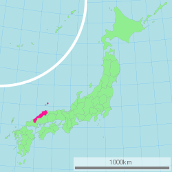
Shimane Prefecture
| Shimane Prefecture | |||||||||
|
|||||||||
 |
|||||||||
| Capital | Matsue | ||||||||
| Region | Chūgoku | ||||||||
| Island | Honshū | ||||||||
| Governor | Zenbei Mizoguchi | ||||||||
| Area (rank) | 6,707.29 km² (18th) | ||||||||
| - % water | 2.7% | ||||||||
| Population (October 1, 2000) | |||||||||
| - Population | 761,503 (46th) | ||||||||
| - Density | 114 /km² | ||||||||
| Districts | 7 | ||||||||
| Municipalities | 21 | ||||||||
| ISO 3166-2 | JP-32 | ||||||||
| Website | www1.pref.shimane.lg.jp/contents/ kokusai/kokusai-e/index.html |
||||||||
| Prefectural Symbols | |||||||||
| - Flower | Moutan peony (Paeonia suffruticosa) | ||||||||
| - Tree | Japanese black pine (Pinus thunbergii) | ||||||||
| - Bird | Whooper swan (Cygnus cygnus) | ||||||||
Symbol of Shimane Prefecture |
|||||||||
| Template ■ Discussion ■ Parameter ■ WikiProject Japan | |||||||||
Shimane Prefecture (島根県 Shimane-ken?) is a prefecture of Japan located in the Chūgoku region on Honshū island. The capital is Matsue. It is the second least populous prefecture in Japan, next to the Tottori Prefecture that is a neighboring prefecture on the east side. The prefecture has an area elongated from east to west facing the Chūgoku Mountain Range on the south side and to the Sea of Japan on the north side. Most of the cities are near the shoreline of the Sea of Japan. There is Izumo Taisha in Izumo City, which is one of the oldest Shinto shrines in Japan.
The Oki Islands in the Sea of Japan are also part of Shimane Prefecture, which also claims to have jurisdiction over the South Korea-controlled island of Liancourt Rocks (Takeshima).
Contents |
History

Early History
- See also: Old provinces of Japan
The history of Shimane starts with the Japanese mythology. Shinto god Ōkuninushi was believed to be living in Izumo, an old province in Shimane. The Izumo Shrine, which is in the city of Izumo, honors the god[1]. At that time, the current Shimane prefecture was divided in to 3 parts, Iwami, Izumo, and Oki. That lasted until the abolition of the han system took place in 1871. During the Nara period, Kakinomoto no Hitomaro read a poem on Shimane's nature when he was sent as the Royal governor.[2] Later on in the Kamakura period, Kamakura Shogunate forces emperors Gotoba and Emperor Godaigo to exile to Oki. Emperor Godaigo later gets away from Oki and begins rallying against the shogunate, which later succeeds.[3]
Middle Ages
During the Muromachi period, Izumo and Oki were controlled by the Kyogoku clan. However, after the Ōnin War, the Amago clan expanded power based in Gassan-Toda castle. However, in 1566 Mori Motonari conquered Izumo, Iwami, and Oki.[3] After over 30 years of Mori control, in 1600 Horio Yoshiharu enters Izumo and Oki as the result of Battle of Sekigahara which Mori lost. Following the change, Horio Yoshiharu decides to move to build Matsue castle instead of Gassan-Toda, and soon after Yoshiharu's death the castle is completed. Later in 1638, the grandson of Tokugawa Ieyasu, Matsudaira Naomasa enters the castle since the Horio clan had no heir, and his family ruled until the abolition of the han system. The Iwami area was split in to 3 clans:The mining district (direct control of the Shogunate), the Hamada clan and the Tsuwano clan. The Iwami Ginzan, now a UNESCO World Heritage Site produced silver and was one of the nation's largest silver mine by the early 17th century. Hamada clan was on the shogunate's side in the Meiji Restoration, and the castle was burned down. The Tsuwano clan, despite the Matsudaira (relative of the shogun) rule was on the emperor's side in the restoration.[4]
Modern times
In 1871, abolition of the han system places the old Shimane and Hamada provinces in the current area of Shimane Prefecture. Later that year, Oki becomes part of Tottori. In 1876, Hamada Prefecture merges with Shimane and is named Shimane Prefecture. Also, Tottori Prefecture merges in the same year. However, five years later, in 1881, the current portion of Tottori Prefecture separates and the current border is formed.[4]
Geography
Shimane prefecture is situated on the Sea of Japan side of the Chugoku region. Because of its mountainous landscape, rice farming is done mostly in the Izumo plain where the city of Izumo is located.[5] Another major landform is the Shimane peninsula. The peninsula is located across on the Sea of Japan from Izumo to Sakaiminato, which apparently is located in Tottori prefecture. Also, the peninsula created two sea water lakes Lake Shinji and Nakaumi. The island of Daikon is located in Nakaumi. Off from the island of Honshū, the island of Oki is in Shimane prefecture as well. The island itself is in the Daisen-Oki National Park.[5] Shimane also claims the use of Liancourt Rocks, which they are in dispute with South Korea. [6]
Most major cities are located either on the seaside, or along a river.[5] Between 2004 and 2005, municipalities across Japan merged, and Shimane prefecture was not an exception. For a the list of mergers, see List of mergers in Shimane Prefecture.
Cities
Eight cities are located in Shimane Prefecture, the largest being Matsue, the capital, and the smallest being Gotsu. The cities Masuda, Unnan, Yasugi, and Gotsu had a slight population increase due to the mergers in the early 2000s. [7]
|

Cape Hinomisaki near Izumo
|
Towns and villages

The number of Towns and villages greatly decreased during the mergers. However, they hold about one-third of the prefecture's population. [7]
|
|
|
Mergers
Climate
The prefecture has a sub-tropical climate. Winter is cloudy with a little snow and summer is a little humid. The year average for temperature is 14.6 degrees Celsius. During the rainy season, June to around Mid July, it rains every day. The hottest average temperature is in August with 26.3 degrees Celsius. The average year preciparation is 1799 millimeters, compared to Tokyo's 1467 mm and Obihiro with 920 mm. [7]
Transportation
Airports

Three airports serve Shimane. The Izumo Airport located in Hikawa is the largest airport in the prefecture in terms of passengers, which has regular flights to Haneda Airport, Osaka Airport, Fukuoka Airport, and Oki Airport. The Iwami Airport has two flights each day to Haneda and Osaka and 2 arrivals. Oki Airport has scheduled flights to Osaka and Izumo Airports. [8]
- Izumo Airport
- Iwami Airport
- Oki Airport
Rail
JR West and Ichibata Electric Railway serves the prefecture in terms of rail transportation. The Sanin Main Line goes through the prefecture on the Sea of Japan side going into major cities such as Matsue and Izumo.[9] Izumoshi and Matsue stations are the major stops in the prefecture. The Kisuki line, which forks from Shinji Station on the Sanin Line, connects with the Geibi Line in Hiroshima Prefecture, cutting into the Chūgoku Mountains.[9] Ichibata Electric Railway serve the Shimane peninsula from Dentetsu-Izumoshi Station and Izumo Taisha-Mae Station to Matsue Shinjiko-Onsen Station. [10]
JR West has 3 Limited Express trains to Shimane, which are Super Matsukaze, Super Oki, and Yakumo.[11]
- West Japan Railway Company
- Sanin Main Line
- Sankō Line
- Kisuki Line
- Yamaguchi Line
- Ichibata Electric Railway
- Kita-Matsue Line
- Taisha Line
Roads
Highways
The four expressways in the prefecture connect major cities with other prefectures. The Matsue expressway connects Matsue with Unnan and Yonago in Tottori prefecture. Hamada Expressway forks from the Chugoku Expressway at Kita-Hiroshima and stretches to Hamada. [5]
- Sanin Expressway
- Matsue Expressway
- Hamada Expressway
- Chūgoku Expressway
Economy
In Shimane, the largest employer is the retailing industry, employing over sixty-thousand workers. Mishimaya and Juntendo are examples of the companies. The manufacturing industry has the second number of employees with forty-nine thousand workers. Also, in the number of business locations, the retailing industry is first with over twelve-thousand.
Twenty-nine percent of the total industry income is from the service industry, including retailers. Another thirteen percent is from the manufacturing industry.
Companies based in Shimane
Manufacturing
- Izumo Murata Manufacturing
- Shimane Fujitsu
- Mitsubishi Agricultural Machinery
Financial
- The Shimane Bank
- The San-in Godo Bank
Others
- Network Applied Communication Laboratory
- Mishimaya
- Juntendo
- Ichibata Electric Railway
Major factories
- Hitachi Metals
Demographics
One-third of the prefecture's population is concentrated in the Izumo-Matsue area. Otherwise, over two-thirds of the population is on the coastline. The reason is that the Chugoku mountains make the land inland harder to inhabit. Also, Shimane has the largest percentage of the elderly, and the capital Matsue has the smallest population out of all the 47 prefectural capitals.[7]
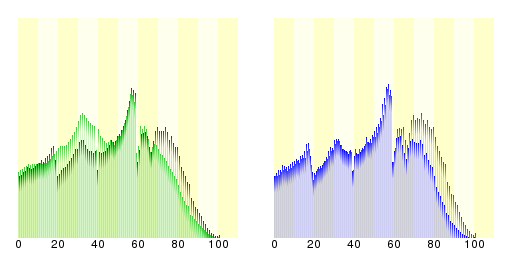
Population by age
Total Population in age groups
2007 Estimated Population
Unit:Thousands
| Age | Population |
|---|---|
| 0 - 4 | |
| 5 - 9 | |
| 10 - 14 | |
| 15 - 19 | |
| 20 - 24 | |
| 25 - 29 | |
| 30 - 34 | |
| 35 - 39 | |
| 40 - 44 | |
| 45 - 49 | |
| 50 - 54 | |
| 55 - 59 | |
| 60 - 64 | |
| 65 - 69 | |
| 70 - 74 | |
| 75 - 79 | |
| 80 and over |
Population in gender
2007 Estimated population
Unit:Thousands
| Male | Age | Female |
|---|---|---|
| 15 |
0 - 4 | |
| 17 |
5 - 9 | |
| 18 |
10 - 14 | |
| 19 |
15 - 19 | |
| 16 |
20 - 24 | |
| 19 |
25 - 29 | |
| 22 |
30 - 34 | |
| 20 |
35 - 39 | |
| 19 |
40 - 44 | |
| 22 |
45 - 49 | |
| 26 |
50 - 54 | |
| 34 |
55 - 59 | |
| 22 |
60 - 64 | |
| 20 |
65 - 69 | |
| 22 |
70 - 74 | |
| 19 |
75 - 79 | |
| 20 |
80 and over |
- Source:Graph 10/Prefectures Age(In Age groups), Gender divided population-Total Population
(Ministry of Internal Affairs Statistics Bureau)
 |
|
| Shimane and it's difference between the national average | Shimane's distribution of age and populations of each of the gender |
|
■Purple is Shimane
■Green is national average |
■Blue is for male
■Red is for females |
| Ministry of Interior Statistics department (Japan) 2005 census | |
Culture
Universities in Shimane Prefecture
Tourism
- Shimane Vogel Park

Prefectural symbols
The prefectural flower is the Mooutan Peony. On the island of Daikonjima , they were grown from at least the 18th century.[12]
References
- ↑ Izumo Shrine website
- ↑ Shimane Prefecture introduction
- ↑ 3.0 3.1 古川清行 Furukawa Kiyoyuki (2003). スーパー日本史 Super Nihon-shi. 講談社 Kōdansha. ISBN 406204594.
- ↑ 4.0 4.1 History of Shimane Prefecture
- ↑ 5.0 5.1 5.2 5.3 新編 中学校社会科地図 Updated Social studies map for Junior High school. 帝国書院 Teikoku Shoin. 2007. ISBN 4-8071-4091-4.
- ↑ Liancourt Rocks
- ↑ 7.0 7.1 7.2 7.3 考える社会科地図 Kangaeru Shakaika Chizu. 四谷大塚出版 Yotsuya-Ōtsuka Shuppan. 2005. p. 113.
- ↑ Flight schedule of Oki Airport
- ↑ 9.0 9.1 Route map for JR West
- ↑ Route map of Ichibata Electric Railway
- ↑ JR West website on limited express trains
- ↑ Symbols of Shimane Prefecture: From Shimane Prefecture website
See also
External links
- Official homepage of Shimane Prefecture
- Shimane JET Programme participants homepage
- National Archives of Japan ... Shimane map (1891)
- Adachi Museum of Art
|
|||
| Cities | |||
|---|---|---|---|
| Gōtsu | Hamada | Izumo | Masuda | Matsue (capital) | Ōda | Unnan | Yasugi | |||
| Districts | |||
| Hikawa | Iishi | Kanoashi | Mino | Nita | Ōchi | Oki | Yatsuka | |||
|
|
|||||||||||