Scarborough, Ontario
| City of Scarborough (Dissolved) | |||
|
|||
 |
|||
| Country | Canada |
||
|---|---|---|---|
| Province | Ontario |
||
| Established | 1 January 1850 (township) | ||
| Incorporated Amalgamation |
June 1983 (city) 1 January 1998 |
||
| Government | |||
| - Mayor | David Miller (Toronto Mayor) | ||
| - Governing Body | Toronto City Council | ||
| - MPs | John Cannis, Jim Karygiannis, Derek Lee, John McKay, Dan McTeague, Tom Wappel | ||
| - MPPs | Bas Balkissoon, Lorenzo Berardinetti, Margarett Best, Brad Duguid, Gerry Phillips | ||
| Area [1] | |||
| - Total | 187.70 km² (72.5 sq mi) | ||
| Population (2001)[1] | |||
| - Total | 593,297 | ||
| - Density | 3,160.9/km² (8,186.7/sq mi) | ||
| Time zone | EST (UTC-5) | ||
| - Summer (DST) | EDT (UTC-4) | ||
| Postal code span | M1(B-X) | ||
| Area code(s) | 416, 647 | ||

Scarborough (IPA: /ˈskɑrˌbəroʊ/) (2001 Census 593,297) is the area that forms the eastern part of the City of Toronto, Ontario, Canada. It was named by Elizabeth Simcoe in 1796 who was inspired by the Scarborough Bluffs which reminded her of the white cliffs near her home in England. Initially a collection of rural villages it has grown to become a diverse urban community. Over 200 years it grew from a township to a city, but has been part of the East District of Toronto since 1998. The Scarborough name is still used by local residents, and is recognised by Canada Post as a municipality name.
Scarborough has characteristics of a suburb of old Toronto, but retains much of its own character and flavour. Certain neighbourhoods in Scarborough are popular destinations for new immigrants to Canada, who bring part of their own culture to that of Scarborough. Because of the topography of the Bluffs, the Rouge Valley and the other creeks and minor tributaries, Scarborough is said to be the greenest and leafiest part of Toronto.[2]
Contents |
Etymology
The area was named after Scarborough, Yorkshire, England by Elizabeth Simcoe, the wife of John Graves Simcoe, the first lieutenant governor of Upper Canada. The bluffs along Scarborough's Lake Ontario shores reminded her of the limestone cliffs in Scarborough, England. On 4 August 1793, she wrote in her diary, "The shore is extremely bold, and has the appearance of chalk cliffs, but I believe they are only white sand. They appeared so well that we talked of building a summer residence there and calling it Scarborough."[3] Before then, the area was named Glasgow, after the Scottish community.[4]
Scarborough has acquired several nicknames. The most popular is Scarberia, a portmanteau of Scarborough and Siberia, a reference to its seemingly distant eastern location to downtown Toronto residents.[5] The word originated sometime in the 1960s and has remained a source of contention ever since. In May 1988, Joyce Trimmer, who was campaigning to be mayor of the city of Scarborough said, "The city of Scarborough needs strong leadership if it is to shed its 'Scarberia' image".[6] Scarborough has also acquired nicknames related to the diversity of the area. Such nicknames are typically a combination using the prefix 'Scar' and a suffix derived from the name of a region, nation, or ethnicity. One such nickname is Scarlem, which alludes to Harlem.[7]
History

The first known evidence of people in Scarborough comes from an archaeological site in Fenwood Heights, which has been dated to 8000 BCE.[8] The site contains the remains of a camp of nomadic hunters and foragers, and there is no evidence of permanent settlers.[8]
In the 1600s, the area was inhabited by the Seneca at the village of Ganatsekwyagon,[9] who were later displaced by the Mississaugas, who were themselves displaced by the British settlers who began to arrive in the late 1700s. After surveying the land in 1793, it was opened to settlement by British subjects with the first issue of land patents in 1796, although squatters had already been present for a few years. The first post office opened in 1832, in Scarborough Village.[10]
During the early part of life in Upper Canada, local administration and justice was administered by the colonial government. From 1792 to 1841, magistrates were appointed by District Councils. There were four districts in the colony of which Scarborough was part of the Home District. Partly due to a political reorganization that was a result of the Durham Report, Scarborough gained elected representation on the Home District Council. Scarborough elected two councillors.[11]
In 1850, Scarborough was incorporated as a township.[12] After incorporation, Scarborough government was lead by a reeve, a deputy-reeve and three councillors each elected annually.[13] Initially the council met in the village of Woburn but it was relocated to Birchcliff in 1922 where most of the population was then located. During the Great Depression the local government was on the verge of bankruptcy. The Ontario Municipal Board stepped in and appointed an oversight committee. This managed to prevent the collapse of local government.[11]
The expansion of Toronto in the west, in the 19th century, led to the development of housing stock along the Kingston Road and Danforth Road corridors in Scarborough. This led to the creation of a transit line. In 1893, the Toronto and Scarboro' Electric Railway, Light and Power Company built a single track radial line along Kingston Road to Blantyre. Over the next 13 years this was extended to West Hill. In 1904, the line became the Scarboro Division of the Toronto and York Radial Railway. Service continued along this line until 1936 when it was replaced by bus service.[11]
As the urban area continued to expand, much of rural Scarborough was converted to suburban housing developments in the last third of the 20th century. At the start of the 21st century, growth has occurred along the Highway 401 corridor at the northern end of the Scarborough RT; highrise condominium projects have increased the residential density around Scarborough City Centre.[10]
On 15 April 1953, Scarborough was included within Metropolitan Toronto, a new upper level of municipal government with jurisdiction over regional services such as arterial roads and transit, police, and fire departments. Scarborough retained its local council but gained representation on a new Metro Council. The new council had 24 members, 12 from the old city of Toronto and 12 from the suburban municipalities. The council was not directly elected but was made up of members of each of the local councils. Scarborough's contribution was its reeve who at the time was Oliver Crockford.[11]

In 1967, Scarborough was incorporated as a borough. The reeve was replaced with a mayor. Albert Campbell, who had been reeve since 1957 became Scarborough's first mayor. The new borough's council consisted of the mayor and four members of the board of control (which functioned as an executive committee). There were also 10 aldermen. The mayor and the controllers also sat on Metro Council. In 1973, Scarborough was increased in size when it annexed the West Rouge area of Pickering. The borough's status was changed to city in 1983. The number of aldermen was increased to 14 and the term of office extended to three years from two.[11]
In 1988, there was a reorganization. The board of control was abolished. Alderman was changed to councillor. Six additional metro council positions were created and these were elected separately for the first time. Scarborough's council consisted of a mayor, 14 local councillors and six Metro councillors.[11]
In 1998, Scarborough was amalgamated with North York, Etobicoke, York, East York and the old city of Toronto to become the new city of Toronto.
Geography

Scarborough's borders are Victoria Park Ave. to the west, the Rouge River, the Little Rouge Creek and the Scarborough-Pickering Townline to the east, Steeles Ave. E. to the north, and Lake Ontario to the south.[14]
Topographically, Scarborough is dominated by two watersheds, Highland Creek and the Rouge River. Highland Creek lies almost entirely within Scarborough and occupies approximately 70% of its total area. It occupies the western half of Scarborough while the Rouge River flows through the eastern portion. Both of these rivers flow into Lake Ontario on Scarborough's shore.[15] Due to the location of the Lakeshore CN railway right-of-way, both river deltas are constricted to narrow channels where they flow into the lake.
Highland Creek is the most urbanized watershed in the Toronto area without about 85% of its land use devoted to urban uses.[16] Some sections of the river run through parks and remain in a fairly natural state, while other parts run through industrial or residential districts where the flow is often diverted or channelled. Sections of the creek are marked by deep ravines and valleys, which contain little or no urban development. The deep valley the creek cuts in its bottom sections remains primarily parkland, with little or no development taking place within the valley.
Scarborough is home to an earthen cliff formation known as the Scarborough Bluffs. The Bluffs can be found along the shore of Lake Ontario, stretching about 14 kilometres (8.7 mi), and reaching heights of more than 60 metres (200 ft) in places. They are part of a much larger formation known as the Iroquois Shoreline, most of which is located somewhat further inland. The Iroquois Shoreline marks the extent of a prehistoric lake, Glacial Lake Iroquois, whose level was quite a bit higher than present-day Lake Ontario's. It shrank in size at the close of the last ice age.[17]

Erosion has been a problem along the Scarborough Bluffs. Properties located near the brink have been abandoned, and houses condemned, as the brink wears back away from the lake. Since the 1980s, large areas of beach at the base of the Bluffs have been reinforced with limestone breakwaters and construction rubble infilling.[18]
Scarborough is also notable for the Rouge River Valley, parts of which are still in a natural, wooded state. The valley is home to a great variety of wildlife including deer, foxes, and the occasional coyote.[19]
Climate
Scarborough's climate is very similar to that of Toronto. Its climate is moderate for Canada due to its southerly location within the country and its proximity to Lake Ontario. It has a humid continental climate (Koppen climate classification Dfa), with warm, humid summers and generally cold winters. Mean temperature and precipitation levels closely match Toronto norms. Scarborough tends to have a slightly lower average temperature which is likely due to the weather station being farther from the moderating influence of the lake.[20]
|
|
||||||||||||||
|---|---|---|---|---|---|---|---|---|---|---|---|---|---|---|
| Temperature | ||||||||||||||
| Month | Jan | Feb | Mar | Apr | May | Jun | Jul | Aug | Sep | Oct | Nov | Dec | Mean | |
| Average high °C (°F) | -2.6 (27.3) | -1.6 (29.1) | -3.6 (25.5) | 11.1 (52.0) | 18.4 (65.1) | 23.1 (73.6) | 26.5 (79.7) | 25.1 (77.1) | 20.1 (68.1) | 13.0 (55.4) | 6.7 (44.1) | 0.3 (32.5) | 13 (55) | |
| Mean °C (°F) | -6.1 (21.0) | -5.2 (22.6) | -0.4 (31.3) | 6.6 (43.9) | 13.4 (56.1) | 18.0 (64.4) | 21.5 (70.7) | 20.3 (68.5) | 15.6 (60.1) | 9.0 (48.2) | 3.5 (38.3) | -2.9 (26.8) | 9 (49) | |
| Average low °C (°F) | -9.6 (14.7) | -8.7 (16.3) | -4.3 (24.3) | 2.1 (35.8) | 8.2 (46.8) | 12.8 (55.0) | 16.4 (61.5) | 15.5 (59.9) | 11.1 (52.0) | 4.9 (40.8) | 0.2 (32.4) | -6.2 (20.8) | 6 (42) | |
| Precipitation mm (in) | 56 (2.2) | 50 (2.0) | 66 (2.6) | 78 (3.1) | 81 (3.2) | 72 (2.8) | 72 (2.8) | 92 (3.6) | 94 (3.7) | 72 (2.8) | 88 (3.5) | 78 (3.1) | 74.9 (2.9) | |
| Data recorded at Malvern for Environment Canada. Average data recorded over a 30 year span from 1971 to 2000. | ||||||||||||||

Demographics

In 2001, Scarborough's population was 593,297, with a density of 3,161 square kilometres (1,220 sq mi). A study based on census data between 1996 and 2001 shows that Scarborough's growth rate was more than 6%, the highest growth in Toronto. Its population is second to North York, but if this trend continues it should be the most populated district in Toronto by 2010.[21]
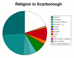
A significant portion of Scarborough's population is composed of immigrants and descendants of immigrants who have arrived in the last four decades. Fifty-four percent of residents are foreign born.[1] Chinese residents make up 17.73% of the population, South Asian residents account for 17.76% of the population, Black Canadian residents make up 10.09% of the population, while Filipino Canadian residents account for 5%.[1] The remaining visible minority groups each represent less than 2% of the population. The immigrant population has created vibrant multicultural locales in various areas of Scarborough. One of the more notable among these is the heavy concentration of Chinese businesses and restaurants in the Agincourt neighbourhood. Many of Scarborough's main arteries, including segments of Kingston Road, Eglinton Avenue East and Lawrence Avenue East, feature Caribbean, Chinese and Halal restaurants and shops, as well as businesses representing the other ethnic groups in the area.[1]
Crime
In 2005, a series of gang-related shootings in some Scarborough neighbourhoods led to the portrayal of Scarborough in the media as crime-ridden.[22] However, long term trends show that Scarborough is less prone to violent crime than the rest of Toronto. Between 1997 and 2006, the ratio of violent crime in Scarborough averaged 20.4%. Scarborough's portion of Toronto's population during that period averaged 23.6%.[23]
Murder rates for Scarborough and Toronto show no particular trend. Between 1997 and 2006, the ratio of murders in Scarborough as compared to the rest of Toronto ranged from a low of 8.8% to a high of 32.2%.[24]
According to Toronto Police Chief Bill Blair, "[42 Division is] the safest division in the city"; this division includes north Scarborough.[25] The safest part of Toronto is north Scarborough from Victoria Park Ave. to the Pickering border, north of Highway 401.[25]
In January, 2008, two councillors claimed that the media was distorting how crime was reported in Scarborough. Norm Kelly and Michael Thompson claimed that whenever a shooting occurred in the rest of the city the location was given as the nearest major intersection. But when a shooting happened in Scarborough the location was given as 'Scarborough'. According to them this gave people an erroneous impression of Scarborough as 'crime-ridden'. They proposed that news outlets sign a 'media protocol' so that all crime locations were given as intersections. However, the city's Executive Committee turned down the request citing this as a form of censorship. Mayor David Miller said "It’s not city council’s role to tell the media how to do their job".[26][27]
Economy
Scarborough is a former borough of Toronto, and as such its economy is an integral component of the economy of Toronto. Scarborough lacks the same level of urban density and business infrastructure development as downtown Toronto. A few farms are still present in the northeast corner of Scarborough, reflective of the area's rural past.[28]
Compared to the City of Toronto as a whole, industry in Scarborough is similar in all labour force categories, save for manufacturing which is higher in Scarborough, and professional, scientific and technical services which are lower.[29] Notable companies that have their headquarters in Scarborough include Toyota Canada Inc., Eli Lilly Canada Inc., Thomson Carswell, CTVglobemedia, Novopharm, Cinram, Honda Canada Inc., Royal Doulton, SKF, Alfa Laval, President's Choice Financial, Aviva, Yellow Pages, and Telus.[30]
Several points of attraction exist between the McCowan transit station and the Midland transit station, including the Town Centre Mall, a public square, government buildings, offices, and new condominiums in recent years. This area has become one of Toronto's new downtowns in the outer boroughs.[31]
Arts and culture
- See also: People from Scarborough, Ontario

Most of the Scarborough based news media have been either weekly or monthly publications. The earliest newspaper was the Scarborough News and Advertiser which was published weekly starting in September, 1921. It lasted until the 1930s. Other short lived papers included The Enterprise (1945 - 1966), Scarborough Mail (1946 - 1955) and The News (1952 - 1995). The only remaining English language local newspaper is the Scarborough Mirror which started publication in 1962. The Ming Pao Daily News is a Chinese language newspaper whose headquarters are in Scarborough. They started production in 1993.[11]
CTV-TV is a national television station whose headquarters are based in the Agincourt area of Scarborough. They started broadcasting in 1961 as CFTO-TV. In 1970, Trillium Cable started to provide cable TV service to Scarborough. It was later purchased by Shaw Cable in 1995. During the early days of the company they produced several local shows for their own cable channel. These shows were produced by volunteers and showed a wide variation in quality. These shows were satirized by Mike Myers on his hit comedy Wayne's World.[11]
Scarborough residents have developed their own unique sense of humour, as evidenced by Mike Myers, whose Wayne's World character was inspired by growing up in the area.[32] Other Scarborough natives include Eric McCormack[32] (Will & Grace), John Candy[32] (Second City, SCTV), and musical group Barenaked Ladies. Jim Carrey (Ace Ventura, Dumb and Dumber, Bruce Almighty) also lived in Scarborough during his teen years.[32] Scarborough has also proved to be the home of prominent hip-hop artists, including Maestro Fresh Wes, Choclair, Kardinal Offishall, Saukrates, and the group BrassMunk.[33]
According to the list of largest shopping malls in Canada, the Scarborough Town Centre is the 8th largest in the country and the 4th largest in the GTA. It is located next to the Scarborough Civic Centre, Albert Campbell Square, and Consilium Place. This area was developed as a city centre under the old City of Scarborough government. The Scarborough Walk of Fame is also located in the Town Centre, consisting of plaques embedded in the floor to honour notable residents, past and current. The inaugural inductees included National Basketball Association player Jamaal Magloire, Olympic gold medalist Vicky Sunohara, and eight prominent residents who contributed to advances in medicine, arts, and the community.[34]
In 1974, the Toronto Zoo was moved from its original downtown location to its current location in the Rouge River valley. The new location enabled the zoo to increase its overall area from 3 hectares (7.4 acres) to over 300 hectares (740 acres). The zoo was transformed at this time from a 19th century zoo with a few animals cramped behind iron bars into a zoo where space was provided to animals and the setting attempted to duplicate the animals' natural environments.[35]

The topography of Scarborough has provided the area with an abundance of golf courses. There is a mix of public and private courses. Dentonia Park is a public course established in 1967 and is situated in the Taylor-Massey Creek ravine beside the Victoria Park subway station.[36] Formerly a private club, the Tam O'Shanter Golf Course was established in 1973 as a public course and is located alongside Highland Creek.[36] Private clubs include the Toronto Hunt Club which was the first golf course in Scarborough, established in 1895 alongside Lake Ontario.[37] and the Scarboro Golf and Country Club was established in 1912.[38] The Cedarbrae Golf & Country Club was established in 1922 and moved to its current Rouge River Valley location at Steeles Ave East in 1954.[39]
On 17 May 2006, the Nike Malvern Sports Complex was opened in the Malvern neighbourhood. Nike Canada donated $500,000 to build the complex, which includes a basketball court, a practice soccer pitch, and a running track. The track was constructed from 50,000 used running shoes. The complex was built on the grounds of the Blessed Mother Teresa Catholic Secondary School and is open to the public. Olympic hurdler Perdita Felicien was on hand at the opening to encourage youth to participate in sports.[40]
Scarborough is one of the prominent destination areas for Tamils in the GTA who have fled Sri Lanka because of civil war. Efforts to integrate Sri Lankan culture include; establishing cross-cultural and cross-national alliances, the building of many Tamil schools across the GTA.[41]
Education
- See also: Educational institutions in Scarborough, Ontario
Scarborough's first schoolhouse opened in 1805 on the Thomson farmstead. In 1847 Egerton Ryerson recommended that 11 school districts be created. By 1904, 28 schools had been built throughout the township. In 1914, Agincourt Continuation School offered education from up to grade 12.[11]
Both Agincourt Collegiate Institute and R.H. King Academy claim to be the oldest secondary schools in Scarborough. Agincourt Collegiate Institute opened in 1915[42] as the Agincourt Continuation School. It became a high school in 1954. R.H. King Academy opened in 1922 as the Scarborough High School being the first high school for in the Scarborough area at that time and became a collegiate in 1930.[43] Scarborough portion of schools is roughly proportional to population. For example, there are 28 secondary schools out of a total of 110 in the public school board which is about 25% of the total.[44]
Scarborough has two post-secondary institutions. Centennial College was opened in 1966. It was the first community college to open in Ontario. Starting from one campus in Warden Woods, it now boasts four campuses across Scarborough. It has 12,000 full time and 28,000 part-time students.[45] The University of Toronto expanded in 1964 by adding satellite campuses in Scarborough and Mississauga. As of 2006, University of Toronto Scarborough has an enrolment of 10,000 students.[46]
Governance
Scarborough is represented by five ridings for the Provincial government and five full ridings plus one partial riding for the Federal government. The Federal riding of Pickering—Scarborough East straddles the border between Scarborough and Pickering. Municipal riding boundaries were harmonized within the City of Toronto to match the provincial boundaries in 1999 through provincial legislation called The Fewer Municipal Politicians Act of 1999. This took effect on 1 December 2000.[47] Each provincial riding is split between two city councillors. Thus Scarborough is represented by ten councillors.
The only direct representation is through the Scarborough Community Council which includes all ten Scarborough councillors.[48] The community council meets once a month at the former offices of the city of Scarborough just south of the Scarborough Town Centre. The council deals with a variety of local issues such as outdoor patio applications, neighbourhood traffic plans, and exemptions from certain by-laws such as retail signs, fences, trees and ravines.[49] However, the council has no direct power - all decisions made must vetted by Toronto City Council in order to take effect.[50]
Infrastructure
Public transit

Scarborough is at the eastern terminus of the Bloor-Danforth subway line which is operated by the Toronto Transit Commission (TTC). There are three subway stations in Scarborough - Victoria Park, Warden, and Kennedy. Beginning at Kennedy station, a separate system called the Scarborough RT runs north and east toward Scarborough Town Centre. It runs at grade for two stops until Ellesmere Avenue where it becomes elevated until it reaches its terminus at McCowan Road. The system is nearing the end of its life and the city is reviewing replacement options, including turning it into a streetcar route or an extension of the City's subway system.[51] In addition to the subway and the RT line, the TTC runs an extensive bus network throughout Scarborough. Many of the bus lines run to and from the subway and RT stations.
The GO Transit authority has two major commuter train lines running through Scarborough, and operates seven GO train stations. The Lakeshore East line runs across the south end of the city, while the Stouffville line runs in a more north-south fashion in the centre of Scarborough. GO Transit also has a few bus stations and stops in Scarborough which provide connections out of Scarborough. Greyhound Bus runs services in Scarborough, although most Greyhound destinations are only served through the Toronto Bus Terminal located downtown.[52]
As of 2008, Toronto is investigating the feasibility of creating a Light Rapid Transit network through parts of Scarborough. Called Transit City, the plan would extend east and north from existing subway and SRT stations.[53]
Roads and highways
The only major freeway in Scarborough is Highway 401, which connects Windsor, Ontario to Montreal, Quebec and spans 825 kilometres (513 mi). The highway runs east-west across the middle of Scarborough, with six to eight lanes in each direction. The short, minor freeway Highway 2A runs parallel to Lake Ontario in the eastern part of Scarborough. In the late 1960s, a plan was formed to link Highway 2A with an eastern extension of the Gardiner Expressway. The planned route known as the Scarborough Expressway would have travelled next to the Canadian National Railway railway lines parallel to Kingston Road. The plan failed to materialize but land acquisitions for the expressway route beside the tracks remain vacant. Currently there are plans to turn it into a mix of housing and parkland.[54]
The arterial roads of Scarborough are generally aligned either north-south or east-west. Kingston Road and Danforth Road are two significant exceptions to this grid, both running diagonally in a southwest-northeast direction across the south end of Scarborough. From north to south, the major east-west arterial roads are Steeles Avenue, Finch Avenue, Sheppard Avenue, Ellesmere Road, Lawrence Avenue, Eglinton Avenue and St. Clair Avenue. From west to east, the major north-south arterial roads are Victoria Park Avenue, Warden Avenue, Birchmount Road, Kennedy Road, Midland Avenue, Brimley Road, McCowan Road, Markham Road, Neilson Road, Morningside Avenue, Meadowvale Road and Port Union Road.[55]
Water and sewage
Scarborough's drinking water is supplied by the R.C. Harris Filtration Plant at the foot of Victoria Park Avenue and the F.J. Horgan Filtration Plant.[56] Wastewater for Scarborough is treated at the Highland Creek Water Pollution Control Plant. This plant was constructed in 1954 and started processing in 1956. It has undergone continual expansion to meet ongoing demand.[56]
Solid waste
Early garbage collection in Scarborough was performed by individual communities and dumped in local landfills which were located in nearby ravines. In 1967 waste collection was reorganized. Local landfills were closed and most of the garbage was directed to a new landfill on Beare Road in eastern Scarborough. This dump was eventually closed in 1981. A waste transfer site was constructed near Markham Road and Sheppard Ave. East. From there garbage was trucked to the Keele Valley dump in Vaughan and the Brock Road dump in Pickering.[11] In 2002 the Keele Valley landfill was closed. As part of Toronto's overall waste management, garbage was then trucked to Michigan. This arrangement is scheduled to last until 2010. At that time, garbage will then be sent to the new Green Lane Landfill site in Elgin County.
See also
- List of mayors of Scarborough, Ontario
- List of neighbourhoods in Scarborough
References
- ↑ 1.0 1.1 1.2 1.3 1.4 1.5 1.6 "2001 Community Profiles". Statistics Canada. Retrieved on 2008-04-10.
- ↑ Kuitenbrouwer, Peter (2006-07-08). "How green is my city?", National Post. Retrieved on 2006-07-19.
- ↑ "Travels with Elizabeth Simcoe". Ministry of Government and Consumer Services (Ontario). Retrieved on 2006-08-05.
- ↑ "Scarborough Historical Society". Scarborough Historical Society. Retrieved on 2007-08-23.
- ↑ DiManno, Rosie (2007-01-15). "A cheeky look at the rump of Toronto: Shhh on the S-word, coupled with crime, councillors say", Toronto Star.
- ↑ Fulford, Robert (March 1996). Accidental City: The Transformation of Toronto. Houghton Mifflin. pp. 112. ISBN 0395773075.
- ↑ Brown, Maureen (2003-03-31). "Growing up black in Oakville" (PDF). Community Development Halton. Retrieved on 2006-06-15.
- ↑ 8.0 8.1 McCowan, Bruce (1995-03-23). "Scarborough Fair: The first settlers foraged 10,000 years ago", Toronto Star, p. SC. 2.
- ↑ "Native and Newcomers, 1600–1793". Municipal government of Toronto. Retrieved on 2008-05-02.
- ↑ 10.0 10.1 "Scarborough History". Stand Up Scarborough. Retrieved on 2008-04-10.
- ↑ 11.00 11.01 11.02 11.03 11.04 11.05 11.06 11.07 11.08 11.09 11.10 Schofield, Richard; Meredyth Schofield, Karen Whynot (1996). Scarboro: Then and Now. Scarborough: Scarborough Board of Education, Scarborough Historical Society.
- ↑ "City of Toronto Website". Municipal government of Toronto. Retrieved on 2006-07-06.
- ↑ "Scarborough Community Names". Scarborough Historical Society. Retrieved on 2008-05-11.
- ↑ "Map of Slo-Pitch Parks& Slo-Pitch Diamonds". Slopitch 1. Retrieved on 2008-04-21.
- ↑ "Watershed Strategies". Toronto and Region Conservation Authority. Retrieved on 2008-05-11.
- ↑ "About Highland Creek". Toronto and Region Conservation Authority. Retrieved on 2008-05-11.
- ↑ "Hello from Toronto – Summer in T.O. Positively Rocks". Travel & Transitions (2006-07-31). Retrieved on 2008-04-21.
- ↑ "Lakeshores Old and New". Natural Resources Canada. Retrieved on 2008-04-21.
- ↑ "For Buyers". Toronto Real Estate. Retrieved on 2008-04-21.
- ↑ Canadian climate normals for 1971 to 2000, Environment Canada (2004). Retrieved on 2006-12-17.
- ↑ "When you want to know Scarborough, Ontario". Scarborough Direct. Retrieved on 2008-05-02.
- ↑ Nicholas Kohler, "Mayor blames lax U.S. gun laws after day of gunplay", National Post, 27 July 2005, A1.
- ↑ Toronto Police Service. Year-to-date Statistics, 1997-2006. Data for violent crime was summarized for 1st and 2nd degree murder, manslaughter, attempted murder, sexual assaults, and all other assaults and totaled for Divisions 41, 42, and 43. Toronto Police Service YTD Stats
- ↑ Toronto Police Service. Year-to-date Statistics, 1997-2006. Data for murder was summarized for 1st and 2nd degree murder and totaled for Divisions 41, 42, and 43. Toronto Police Service YTD Stats
- ↑ 25.0 25.1 Milley, Danielle (2008-04-16). "Police bring message of safety to 42 Division meeting". Daily Mirror. Retrieved on 2008-04-28.
- ↑ "Scarborough Tries To Clear Its "Crime" Rep". CityNews. Retrieved on 2008-05-16.
- ↑ Chris Richardson. "A Tale of Two Scarboroughs". The Ryersonian. Retrieved on 2008-05-16.
- ↑ "Scarborough". Encyclopedia Britannica. Retrieved on 2008-04-21.
- ↑ "City of Toronto's community economic profile for Scarborough". Municipal government of Toronto. Retrieved on 2006-08-05.
- ↑ "Innovation Performance—The Greater Toronto Area Region". Government of Canada. Retrieved on 2008-04-21.
- ↑ "Subway schedules". Toronto Transit Commission. Retrieved on 2008-04-21.
- ↑ 32.0 32.1 32.2 32.3 "Scarborough's dilemma". Toronto Star (2008-01-16). Retrieved on 2008-05-12.
- ↑ "Mike Myers". IMDB. Retrieved on 2008-04-21.
- ↑ Ferenc, Leslie (2006-05-18). "Scarborough stars shine on Walk of Fame", Toronto Star, p. A20.
- ↑ Rusk, James (2004-08-16). "Zoo celebrates 30th anniversary", The Globe and Mail.
- ↑ 36.0 36.1 "Toronto Golf History". Municipal government of Toronto. Retrieved on 2008-05-03.
- ↑ "Toronto Hunt Club AGM". International Wine & Food Society of Toronto. Retrieved on 2008-04-21.
- ↑ "Scarboro Golf & Country Club". Retrieved on 2008-05-03.
- ↑ "Cedar Brae Golf & Country Club". Retrieved on 2008-05-03.
- ↑ Christie, James (2006-05-18). "Malvern complex aimed at youth", The Globe and Mail.
- ↑ Durak, Sean (2003-03-30). "Newcomers find a home in Scarborough". Tamil Canadian. Retrieved on 2008-04-21.
- ↑ "Agincourt Collegiate Institute's Website". Retrieved on 2006-07-06.
- ↑ "R.H. King Academy website". Retrieved on 2006-07-06.
- ↑ "School Listing". Toronto District School Board. Retrieved on 2008-05-11.
- ↑ "College Profile". Centennial College. Retrieved on 2008-05-11.
- ↑ "Facts & Figures". University of Toronto Scarborough. Retrieved on 2008-05-11.
- ↑ "Pre-November 2003 Community Councils History". Municipal government of Toronto. Retrieved on 2008-05-11.
- ↑ "Scarborough Community Council - Area D". Municipal government of Toronto. Retrieved on 2008-05-11.
- ↑ "2008 Scarborough Community Council Agendas and Minutes". Municipal government of Toronto. Retrieved on 2008-05-11.
- ↑ "Community Councils". Municipal government of Toronto. Retrieved on 2008-05-11.
- ↑ "Scarborough RT Strategic Plan – Study Report - Final Report - August 2006". Retrieved on 2008-03-30.
- ↑ ""Toronto Transit Commission (TTC) Times Two"". Toronto Transit Commission. Retrieved on 2008-04-21.
- ↑ Tess Kalinowski. New LRT lines will head east. Toronto Star. 4 June 2008. [1]
- ↑ "Transportation: Highways". Found Locally. Retrieved on 2008-04-21.
- ↑ "Kingston Road". Municipal government of Toronto. Retrieved on 2008-04-21.
- ↑ 56.0 56.1 Fenco MacLaren Inc. et al. (December 1996.). Integrated Shoreline Management Plan, Tommy Thompson Park To Frenchman’s Bay.. Toronto.
External links
- Scarborough Historical Society and Scarborough Archives
- Scarborough section of Toronto Archives
- Scarborough Walk of Fame
|
|||||||||||
|
||||||||||||||||||||