Saxony-Anhalt
| Sachsen-Anhalt Saxony-Anhalt |
|||
| Flag | Coat of arms | ||
|
|||
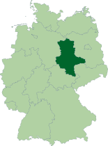
| Location | |||
 |
|||
| Time zone | CET/CEST (UTC+1/+2) | ||
| Administration | |||
| Country | Germany | ||
| NUTS Region | DEE | ||
| Capital | Magdeburg | ||
| Largest city | Halle | ||
| Minister-President | Wolfgang Böhmer (CDU) | ||
| Governing parties | CDU / SPD | ||
| Votes in Bundesrat | 4 (of 69) | ||
| Basic statistics | |||
| Area | 20,445 km² (7,894 sq mi) | ||
| Population | 2,420,000 (09/2007)[1] | ||
| - Density | 118 /km² (307 /sq mi) | ||
| Other information | |||
| GDP/ Nominal | € 48 billion (2005) | ||
| ISO region | DE-ST | ||
| Website | sachsen-anhalt.de | ||


Saxony-Anhalt (German: Sachsen-Anhalt) is one of the sixteen Bundesländer (federal states) that make up the Federal Republic of Germany. It has an area of 20,447 square kilometres (7,895 sq mi), and a population of 2.45 million (more than 2.8 million in 1990). Its capital is Magdeburg.
Contents |
Geography
Saxony-Anhalt is one of 16 states in the Federal Republic of Germany. It covers a total area of 20,445 km² (12,676 sq. miles). By size, it is the 8th largest state in Germany, and by population, the 10th largest. It borders the states of Brandenburg, Saxony, Thuringia and Lower Saxony.
The capital of Saxony-Anhalt is Magdeburg. It is the second largest city in the state, after Halle. Nearby is the city of Dessau, where the "Bauhaus" is located. The Bauhaus provided a basis for the field of architecture and fine arts in the area. Dessau is also home to the opulent Dessau-Wörlitz Garden Realm. The city’s main attraction is the Wörlitzer Park which is part of the UNESCO World Heritage Site.
The landscape of Saxony-Anhalt is quite varied. From the region of Altmark in the north, the state extends from the Magdeburg region, a vast lowland, through the Harz, a low mountain range, until one comes to Thuringia. The highest mountain in the vicinity is Brocken, with an elevation of 1,141 meters (3,735 ft). Below the summit, the National Park Harz forms an extensive wildlife sanctuary.
See also List of places in Saxony-Anhalt.
Administrative subdivision
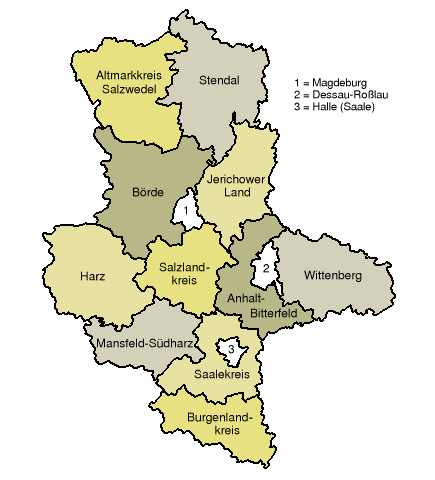
From 1994 to 2003, Saxony-Anhalt was divided into 21 districts ("Landkreise"). Above this level, there were three governmental districts (Regierungsbezirke): Dessau, Halle and Magdeburg. On January 1, 2004 these three governmental districts were abolished.
A further reform, effective from July 2007, reduced the 21 districts to 11 districts (Landkreise):
- Altmarkkreis Salzwedel
- Anhalt-Bitterfeld
- Börde
- Burgenlandkreis
- Harz
- Jerichower Land
- Mansfeld-Südharz
- Saalekreis
- Salzlandkreis
- Stendal
- Wittenberg
and three urban districts (Stadtkreise):
- Dessau-Roßlau
- Halle (Saale)
- Magdeburg
History
The geographical concept of Saxony has undergone considerable shifts over the course of the past 15 centuries. The land of the Saxons, Saxony was in Frankish times roughly the area of northwestern Germany between the rivers Elbe and Ems; it also included part of south Jutland. This area corresponds roughly to that of the federal German state of Lower Saxony established after World War II and western parts of Saxony-Anhalt.
The Duchy of Saxony
After Charlemagne's conquest (772–804) of the Saxons, their homeland was incorporated in the Carolingian empire. By the latter half of the 9th century it was recognized as the duchy of Saxony. Comprising the four divisions of Westphalia, Angria, Eastphalia, and Holstein, it embraced nearly all the territory between the Elbe and Saale rivers on the east and the Rhine on the west, and bordered on Franconia and Thuringia in the south. Duke Henry I (Henry the Fowler) of Saxony was elected German king in 919. His son, Emperor Otto I, bestowed (961) Saxony on Hermann Billung (d. 973), a Saxon nobleman, whose descendants held the duchy until the extinction of the male line in 1106. Lothair of Supplinburg (Lothair III) bestowed it on his Guelphic son-in-law, Henry the Proud, who was already duke of Bavaria.
In 1142 the duchy passed to Henry the Lion, son of Henry the Proud. The struggle between Henry the Lion and Emperor Frederick I ended with Henry's loss of all his fiefs in 1180. The duchy was broken up into numerous fiefs. The Guelphic heirs of Henry the Lion retained only their allodial lands, the duchy of Brunswick. The ducal title of Saxony was passed to Bernard of Anhalt, a younger son of Albert the Bear of Brandenburg and founder of the Ascanian line of Saxon dukes. Besides Anhalt, Bernard received Lauenburg and the country around Wittenberg, on the Elbe. These widely separate territories continued after 1260 under separate branches of the Ascanians as Saxe-Lauenburg and Saxe-Wittenberg.
Electoral Saxony
The Golden Bull of 1356 raised the duke of Saxe-Wittenberg to the hereditary rank of elector, i.e., member of the college that elected the Holy Roman Emperor. Electoral Saxony, as his territory was called, was a relatively small area along the middle Elbe. To the south of Electoral Saxony extended the margraviate of Meissen, ruled by the increasingly powerful house of Wettin. The margraves of Meissen acquired (13th–14th cent.) the larger parts of Thuringia and of Lower Lusatia and the intervening territories, and in 1423 Margrave Frederick the Warlike added Electoral Saxony; he became (1425) Elector Frederick I. Thus, the land known as "Saxony" shifted southeastward from the original Saxon homeland in northwestern Germany.
In 1485 the Wettin lands were partitioned between two sons of Elector Frederick II; the division came to be permanent. Ernest, founder of the Ernestine branch of Wettin, received Electoral Saxony with Wittenberg and most of the Thuringian lands. Albert, founder of the Albertine branch, received ducal rank and the Meissen territories, including Dresden and Leipzig. Duke Maurice of Saxony, a grandson of Albert and a Protestant, received the electoral title in the 16th century; it remained in the Albertine branch until the dissolution (1806) of the Holy Roman Empire.
Saxon Kings of Poland
The rivalry between Saxony and Brandenburg (after 1701 the kingdom of Prussia) was a decisive factor in later Saxon history, as was the election (1697) of elector Frederick Augustus I of Saxony as king of Poland (King Augustus II); the personal union contributed to the formation of close economic ties between the declining Poland and Saxony, whose prestige was thereby diminished. In the War of the Austrian Succession, Saxony adhered to what had become its traditional wavering policy, changing sides in the middle of the conflict. The death (1763) of Augustus III ended the union with Poland.
The period of Saxon rule in Poland marked a time of economic and social decay but of cultural and artistic flowering. Augustus II and Augustus III were lavish patrons of art and learning and greatly beautified their capital, Dresden. The universities of Wittenberg and Leipzig had long been leading intellectual centers, and 18th-century Leipzig led in the rise of German literature as well as in music, which reached its first peak in J. S. Bach.
Saxony sided with Prussia against France early in the French Revolutionary Wars, but changed sides in 1806. For this act its elector was raised to royal rank, becoming King Frederick Augustus I. His failure to change sides again before Napoleon's fall cost him (1815) nearly half his kingdom at the Congress of Vienna. The kingdom of Saxony lost Lower Lusatia, part of Upper Lusatia, and all its northern territory including Wittenberg and Merseburg to Prussia. Its principal remaining cities were Dresden, Leipzig, Chemnitz, and Plauen. The larger part of the territories ceded in 1815 were incorporated with several other Prussian districts into the Prussian province of Saxony, with Magdeburg its capital. This was united after 1945 with Anhalt to form the state of Saxony-Anhalt and became part of the German Democratic Republic (East Germany) in 1949. From 1952 to 1990 Saxony-Anhalt was divided into the East German districts of Halle and Magdeburg. In 1990, in the course of German reunification, the districts were reintegrated as a state.
Politics
List of minister presidents of Saxony-Anhalt
1945–1952
- 1945–1949: Erhard Hübener (LDPD)
- 1949–1952: Werner Bruschke (SED)
1990 to date
- 1990–1991: Gerd Gies (CDU)
- 1991–1993: Werner Münch (CDU)
- 1993–1994: Christoph Bergner (CDU)
- 1994–2002: Reinhard Höppner (SPD)
- since 2002: Wolfgang Böhmer (CDU)
March 26, 2006 state election
See also: Saxony-Anhalt state election, 2006
Minister-president Wolfgang Böhmer (CDU) could not continue his coalition with the FDP and negotiated a grand coalition with the SPD instead.
| Party | Party List votes | Vote percentage | Total Seats | Seat percentage |
|---|---|---|---|---|
| Christian Democratic Union (CDU) | 326,712 | 36.2% | 40 | 41.2% |
| The Left Party (Die LINKE(PDS/WASG)) | 217,285 | 24.1% | 26 | 26.8% |
| Social Democratic Party (SPD) | 192,754 | 21.4% | 24 | 24.7% |
| Free Democratic Party (FDP) | 60,207 | 6.7% | 7 | 7.2% |
| Alliance '90/The Greens | 32,118 | 3.6% | 0 | 0.0% |
| German People's Union (DVU) | 26,894 | 3.0% | 0 | 0.0% |
| All Others | 46,235 | 5.0% | 0 | 0.0% |
| Totals | 902,205 | 100.0% | 97 | 100.0% |
Economy
Saxony Anhalt is famous for its good soil. The "Magdeburger Börde" contains the best soil in all of Germany and some of the best of Europe. The food industry has an important role in this state. Some of the best known products are "Baumkuchen" from Salzwedel (Altmark) or "Hallorenkugeln" from Halle.
In the industrial sector the chemical industry is quite important. One of the biggest chemical producing areas can be found around the cities of Wolfen and Bitterfeld. Because of the chemical industry, Saxony Anhalt is the largest receiver of FDIs (Foreign Direct Investments) in all of eastern Germany.
Saxony Anhalt is also the location of numerous "wind farms" throughout the state producing wind-turbine energy. See http://www.wsb.de/home_leistungen_referenzen.html.
Anthem
- Lied für Sachsen-Anhalt ("Song for Saxony-Anhalt")
External links
References
- ↑ "State population". Portal of the Federal Statistics Office Germany. Retrieved on 2007-04-25.
|
|||||||||||