Santa Fe Province
| Santa Fe | |||
| Province | |||
|
|||
| Divisions | 19 departments | ||
|---|---|---|---|
| Capital | Santa Fe | ||
| Area | 133,007 km² (51,354 sq mi) | ||
| Population | 3,000,701 (2001) | ||
| Density | 22.56 /km² (58 /sq mi) | ||
| Governor | Hermes Binner (PS) | ||
| - Senators | Rubén Giustiniani, Carlos Reutemann, Roxana Latorre | ||
| ISO 3166-2 code | AR-S | ||
| Demonym | Santafesino | ||
 |
|||
| Website: http://www.santa-fe.gov.ar | |||

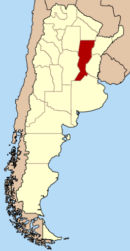
Santa Fe is a province of Argentina, located in the center-east of the country. Neighboring provinces are from the north clockwise Chaco, Corrientes, Entre Ríos, Buenos Aires, Córdoba, and Santiago del Estero. Together with Córdoba and Entre Ríos, the province is part of the economico-political association known as the Center Region.
Santa Fe's most important cities are Rosario (population 908,000), the capital Santa Fe (369,000), Rafaela (83,000), Villa Gobernador Gálvez (74,000), Venado Tuerto (69,000), Reconquista (66,000), and Santo Tomé (58,000).
The adult illiteracy rate in the province is 3.7%.
Contents |
History
The aboriginal tribes who inhabited this region were the Tobas, Timbúes, Mocovíes, Pilagás, Guaycurúes, and Guaraníes. They were nomadic, lived from hunting, fishing and fruit recollection.
The first European settlement was established in 1527, at the confluence of the Paraná and Carcarañá rivers, when Sebastián Gaboto, on his way to the north, founded a fort named Sancti Spiritus, which was destroyed two years later by the natives.
In 1573 Juan de Garay founded the city of Santa Fe in the surroundings of present town Cayastá, but the city was moved in 1651 and 1660 to its present location.
In 1812 the lawyer and general Manuel Belgrano created and displayed for the first time the Argentine flag on the banks of the Paraná River, at Rosario (by that time a small village), 160 km south of Santa Fe.

In 1815, while Alvear's central government felt due to Ignacio Álvarez Thomas' rebellion (at that time commander of an army sent to Santa Fe against Artigas), Francisco Candioti, the local militia chief, took over, peacefully, of government, thus starting the era of Santa Fe as an autonomous province. This period was short lived, since that same year Candioti died and central government reestablished the dependent government. However, in 1816, the caudillos Mariano Vera and Estanislao López deposed the governor delegate and proclaimed the sovereignty of the province and its membership into Artigas's Free Peoples League (Liga de Pueblos Libres).
López drew, in 1818, a provincial constitution of a strongly conservative flavour, after rejecting a project proposed by a provincial assembly; Santa Fe was the first province to have its constitution. During the civil strifes of 1820, Santa Fe troops were decisive in the defeat of Buenos Aires' centralist army. So, in time, López gradually became the Federation's Patriarch, establishing himself as the central figure of the Federal Party until his death in 1838.

After López's death it was his secretary and right hand, José María Cullen the one elected governor. However, being Cullen a potential rival of Buenos Aires governor and Confederation's Foreign Affairs Representative, Juan Manuel de Rosas, he sook and got Cullen's capture and execution, naming pro-Rosas Juan Pablo López as governor. The new governor maintained in power, alterning with Pascual Echagüe, until the province invasion by Justo José de Urquiza's Great Army in 1851, and during his term the province adopted a new constitution in 1841.
After the organization of the nation, the province entered an era of peace and prosperity; in 1872 the railways already connected many points of the province, as well as the telegraph lines, and in 1889 the Provincial University of Santa Fe was founded.

The political hegemony of the conservative groups was challenged by the new ideas brought by the European immigrants gave birth to the Radical Civic Union (UCR) and the Progressive Democratic Party (PDP), and the creation of the Argentine Agrarian Federation. These two parties had many strong electoral contests with the province's conservative parties.
After the Electoral Reform of Roque Sáenz Peña in 1912, the UCR reached the government and stayed until the coup of 1930. During this time, more precisely in 1919, the National University of the Littoral was founded. In 1932 it was the PDP who got the governor's seat.
The contentious 1958 elections (from which Peronist candidates were barred) brought an ally of President-elect Arturo Frondizi to power in Santa Fe, Dr. Carlos Sylvestre Begnis. Gov. Begnis quickly steered budgets into sorely needed public works, most notably the construction of the Hernandarias Tunnel, a 10-mile-long connection between the city of Santa Fe and neighboring Parana. The tunnel, most of which runs under the massive Parana River, is the longest in Argentina.
Forced to resign after conservative pressure drove Pres. Frondizi from office in 1962, Begnis had the satisfaction of seeing Hernandarias open in 1969 and voters overwhelmingly return him to office in 1973 (this time, as a Peronist).
Santa Fe suffered the violence of the late '70s and the depression of the 1980s more than most other provinces. It continued to languish economically during the prosperous 1990s, as the revalued Argentine Peso put pressure on its productive sectors. Touching bottom around 2002, its economy has grown by 7% a year since then. The heart of Argentina's lucrative soy harvest, the province's importance has continued to grow, now rivaling Buenos Aires Province as the nation's leading agricultural producer, with Rosario as one of the most important ports in Argentina.
Geography and climate

Most of the province consists of green flatlands, part of the humid Pampas, bordering to the north with the Gran Chaco region. There are low sierras to the west. The north has higher temperatures, with an annual average of 21 °C and precipitations of up to 1,100 mm in the east, decreasing towards the west, where there is a distinctive dry season during the winter. The south presents lower temperatures, and slightly less precipitations.
The main river, and connection to open sea through the Río de la Plata is the Paraná River. There are also other tributaries to the Paraná including the Salado del Norte, the Carcarañá and the Arroyo del Medio. The plain lands tend to be flooded after heavy rains due to the growth of the Paraná and Salado rivers. In 2003 a rapid rise of the Salado produced a catastrophic flood of the capital and many communities in the north-center of the province, prompting the evacuation of no fewer than 100,000 people and major economic losses. In 2007, several days of heavy rainfall flooded more than 60 towns in the center and south of the province, including sections of Santa Fe and Rosario, causing tens of thousands of people to be evacuated, crop losses, and widespread damage to the physical infrastructure of the area.
Economy

Santa Fe's economy is the fourth most important in the country, having been displaced from third place by neighboring Cordoba Province around 1970. Accounting for 8% of the Argentine total, its output was estimated at US$27 billion in 2006, or, US$9,000 per capita (about the national average).[1] Though the economy is well-diversified, agriculture continues to play an indispensable role through its profitability and foreign exchange earnings via exports. Twenty-one percent of the cultivated lands of Argentina are in Santa Fe, whose main crops are soybean (main national producer), sunflower, maize, wheat, and rice. In smaller scale strawberry, honey and derivatives (300,000 beehives), wood, and cotton are produced.

The green grass of the province is ideal for the 6.5 million heads of cattle (20% of national stock), which is not only source of meat but of 2.6 billion of litres of milk per year (40% of the national production), which is processed by over 5,000 dairies.
The ports between Rosario and San Lorenzo are departure points for the export of the production of the Santa Fe and many other provinces; through them leave 65% of the Argentine cereal and 55% of the country's exports. In 2004, Santa Fe's exports (7,170 million USD) accounted for 21% of the national total. Between 2001 and 2004 they increased 65.2%. Derivates of soybean, flours and vegetable oils comprised over 2 billion USD and over 7.6 million tonnes. [2] In 2005 the ports of southern Santa Fe shipped 60% of the grains, 93% of the agricultural subproducts and 85% of the vegetable oils exported by Argentina. [3]
Manufacturing in Santa Fe represents 18% of its economy[2] and is also among the top in Argentina. Mills that produce different flours and oils, beer, and other food industries, leather and textiles, hydrocarbon refineries, steel (1 million tonnes a year) and metals production, industrial and agricultural machines, car industry and others.
The services sector is well-developed and very diversified, relying little on tourism or the public sector. Tourism is not an important activity in spite of the wide range of hotels and restaurants. Rosario, home to the National Flag Memorial (Monumento Nacional a la Bandera) and a number of museums, receives a number of visitors from Argentina. The replica of the Sancti Spiritus Fort, the ruins of Cayastá and the city of Santa Fe are also common destinations.
Government

The provincial government is divided in the usual three branches: the executive, headed by a governor, popularly elected for non-reelegible four-year terms, who appoint the cabinet; the legislative, formed by a bicameral legislature (a 50-member Chamber of Deputies and a 19-member Senate, all elected for four-year terms); and the judiciary, headed by the Supreme Court and completed by several inferior tribunals.
From 1991, the executive and legislative officials were elected in single-round elections by a controversial system known as the Ley de Lemas. This system was abolished in 2004; the new one includes compulsory primary elections, which were held for the first time in August 2005, with good results according to most analysis. The parliamentary elections of 23 October 2005 were the first main elections to be held after the abolition of the Ley de Lemas.
Administrative division


The province is divided into 19 departments (in Spanish, departamentos), and the departments are divided in districts which can be organized as communes or municipalities. The communes are smaller towns, generally administered by a local commission led by a "communal president". The municipalities, which must have more than 10,000 inhabitants, are what is commonly called "cities". Municipalities have an executive officer (a mayor, called intendente) and a legislative body (called Concejo Municipal, a deliberative council). For administrative purposes, each department has a head town (cabecera), which may be either kind of district.
| Department | Population | Area | Head town |
|---|---|---|---|
| Belgrano | 41,449 | 2,386 km² | Las Rosas |
| Caseros | 79,096 | 3,449 km² | Casilda |
| Castellanos | 162,165 | 6,600 km² | Rafaela |
| Constitución | 83,045 | 3,225 km² | Villa Constitución |
| Garay | 19,913 | 3,964 km² | Helvecia |
| General López | 182,113 | 11,558 km² | Melincué |
| General Obligado | 166,436 | 10,928 km² | Reconquista |
| Iriondo | 65,486 | 3,184 km² | Cañada de Gómez |
| La Capital | 489,505 | 3,055 km² | Santa Fe |
| Las Colonias | 95,202 | 6,439 km² | Esperanza |
| Nueve de Julio | 28,273 | 16,870 km² | Tostado |
| Rosario | 1,121,441 | 1,890 km² | Rosario |
| San Cristóbal | 64,935 | 14,850 km² | San Cristóbal |
| San Javier | 29,912 | 6,929 km² | San Javier |
| San Jerónimo | 77,253 | 4,282 km² | Coronda |
| San Justo | 40,379 | 5,575 km² | San Justo |
| San Lorenzo | 142,097 | 1,867 km² | San Lorenzo |
| San Martín | 60,698 | 4,860 km² | Sastre |
| Vera | 51,303 | 21,096 km² | Vera |
References
External links
- Official portal of the province. (Spanish)
- Constitution of Santa Fe. (Spanish)
- Tourism in Santa Fe, Argentina
|
||||||||||