Sakarya Province
 |
|
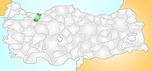
| Location of Sakarya Province in Turkey | |
 |
|
| Overview | |
| Region: | Marmara Region, Turkey |
| Area: | 4,895 (km²) |
| Total Population | 756,168 TUIK 2007 (est) |
| Licence plate code: | 54 |
| Area code: | 0154 |
| Governor Website | http://www.sakarya.gov.tr |
| Weather forecast | turkeyforecast.com/weather/sakarya |
Sakarya is a city and province of the same name in Turkey, located on the coast of Black Sea. The river Sakarya feeds this beautiful location. The river creates a webbing of estuaries in the province.
Sakarya is located in the Marmara Region. Its adjacent provinces are Kocaeli to the west, Bilecik to the south, Bolu to the southeast, and Duzce to the east. The capital of Sakarya is Adapazari. The climate is typically Mediterranean due to its close proximity to the Black Sea. The weather is never cold here, with winters having a fair share of rain. Summers are warm and comfortable.
Sakarya is situated on the Ankara-Istanbul Highway. It is well connected through rail, air and road. Istanbul is the nearest airport. The various tourist spots of Sakarya are also well connected by rail and road from Istanbul.
Historical Importance
Sakarya dates back to 378 BC. First to come here were the Frigs, Brithians, Kimmers, Lydians and Persians. But Sakarya got its identity from the Romans and Byzantine rulers. One of the most important remains of historical significance is the Justinianus Bridge (or Bes Köprü) built by Byzantine Emperor Justinian in 533 CE. The Ottomans were one of the last to be here.
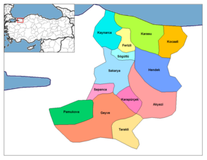
Districts
- Adapazarı
- Akyazı
- Ferizli
- Geyve
- Hendek
- Karapürçek
- Karasu
- Kaynarca
- Kocaali
- Pamukova
- Sapanca
- Söğütlü
- Taraklı
External links
|
||||||||||||||||||||||||||||||||||