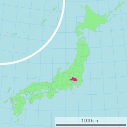
Saitama Prefecture
| Saitama Prefecture | |||||||||
|
|||||||||
 |
|||||||||
| Capital | Saitama | ||||||||
| Region | Kantō | ||||||||
| Island | Honshū | ||||||||
| Governor | Kiyoshi Ueda | ||||||||
| Area (rank) | 3,797.00 km² (39th) | ||||||||
| - % water | 0.5% | ||||||||
| Population (October 1, 2000) | |||||||||
| - Population | 6,938,006 (5th) | ||||||||
| - Density | 1,827 /km² | ||||||||
| Districts | 9 | ||||||||
| Municipalities | 70 | ||||||||
| ISO 3166-2 | JP-11 | ||||||||
| Website | www.pref.saitama.lg.jp/ index_e.html |
||||||||
| Prefectural Symbols | |||||||||
| - Flower | Primrose (Primula sieboldii) | ||||||||
| - Tree | Keyaki (Zelkova serrata) | ||||||||
| - Bird | Eurasian collared dove (Streptopelia decaocto) | ||||||||
Symbol of Saitama Prefecture |
|||||||||
| Template ■ Discussion ■ Parameter ■ WikiProject Japan | |||||||||
Saitama Prefecture (埼玉県 Saitama-ken?) is a prefecture of Japan located on the island of Honshū. The capital is the city of Saitama.
This prefecture is part of the Greater Tokyo Area, and most of Saitama's cities can be described as suburbs of Tokyo, to which floods of residents commute each day.
Contents |
History
Saitama Prefecture was formerly part of the old Musashi Province.
In the fifth year of the Keiun era (708), deposits of copper were reported to have been found in the Chichibu District of what is now Saitama Prefecture.
The Saitama area was historically known as a fertile agricultural region which produced much of the food for the Kantō region. During the Edo period, many fudai daimyo ruled small domains within the Saitama area.
After World War II, as Tokyo expanded rapidly and modern transportation allowed longer commutes, the lack of available land in Tokyo led to the rapid development of Saitama Prefecture, whose population has nearly tripled since 1960. Most of the cities in the prefecture are closely connected to downtown Tokyo by metropolitan rail, and operate largely as residential and commercial suburbs of Tokyo.
Geography

Saitama Prefecture is bordered by Tokyo, Chiba, Ibaraki, Tochigi, Gunma, Nagano, and Yamanashi. It is located central-west of the Kanto region, measuring 103 km from east to west and 52 km from north to south. At 3,797 sq km, it ranks as the ninth smallest prefecture. The eastern border with Chiba Prefecture is defined by the Edo River. The northern and north-western border lines with Gunma Prefecture are marked by the Tone River and the Kanagawa River and the drainage divides of the Arakawa River and Kanagawa River. The southwestern border is defined by the drainage divides of the Arakawa River, Tama River, and Fuefuki River. The eastern section of the southern border line, however, does overlap with any geological feature.
The topography of Saitama Prefecture is largely divided by the Hachiōji Tectonic Line, which runs through Kodama, Ogawa, and Hannō, into the western mountain area and the eastern lowland area. [1] The altitude, highest on the western side, gradually lowers eastward from mountain ranges to hills to plateaus to lowlands. The eastern lowlands and plateaus occupy 67.3 % of the area.[2]
The eastern side, part of the Kantō Plain, can be further divided into 9 separate expanses of hills and10 plateaus. The former occupy small areas neighboring the Kantō Mount Range, including the Hiki Hills and Sayama Hills. The latter are mainly surrounded by alluvial flood plains. In the southeastern portion of the prefecture, the Ōmiya Plateau stands in a southeastward direction, sandwiched by the Furutone River to the east and the Arakawa River to the west. [3]
The western side of the prefecture belongs to the Kantō Mountain Range with Chichibu Basin located in its center. The area to the west of the basin features high peaks such as Mount Sanpō (2,483 m) and Mount Kōbushi (2,475 m), in which the Arakawa River has its source. Most of the land is contained in Chichibu Tama Kai National Park. The area to east of the basin consists of relatively low mountains.[4]
Cities
|
|
|
Towns and villages
Towns and villages in each district:
|
|
|
Mergers
Transportation
Radial transportation to and from Tokyo dominates transportation in the prefecture. Circular routes were constructed as bypasses to avoid congestion in central Tokyo.
Roads
The Jōban, Kan-etsu, Shuto, Tōhoku, and Tokyo-Gaikan expressways form parts of the nationwide expressway network. National highway Routes 4, 16, and 17 are important routes in Kantō region.
Railways
Ōmiya Station in Saitama City forms East Japan Railway Company's northern hub station in the Greater Tokyo Area, offering transfers to and from Shinkansen high-speed lines. The Musashino and Hachikō Lines serve as freight bypass lines as well as passenger lines. Chichibu Railway the northwestern, Seibu Railway the southwestern, Tobu Railway the midwestern and the eastern, the New Shuttle and Saitama Railway the southeastern parts of the prefecture respectively. The Tsukuba Express line crosses the southeastern corner of the prefecture.
- East Japan Railway Company
- Tōhoku Shinkansen
- Jōetsu Shinkansen
- Utsunomiya Line (Tōhoku Main Line)
- Takasaki Line
- Shōnan-Shinjuku Line
- Keihin-Tōhoku Line
- Saikyō Line
- Musashino Line
- Kawagoe Line
- Hachikō Line
Airways
Haneda Tokyo International Airport and Narita International Airport are the closest major civil airports. Commuter helicopter flights from Kawajima to Narita Airport are offered [5].
Honda Airport for general aviation and the JASDF's Iruma Air Base,[6] and Kumagaya[7] Air Base offer no scheduled transport services.
Waterways
Rivers and canals including those developed in the Edo period (17th - 19th centuries) in the east of the prefecture are largely disused following the introduction of motorised land transport. The traces of water transports are found on the Tone River Kumagaya - Chiyoda, Gunma border[8] and on Arakawa River a tourist attraction in Nagatoro, Chichibu District[9] and petroleum tankers from Tokyo Bay to Wakō[10].
Culture
Mass media
See Mass media in Saitama Prefecture.
Sister relationships
Saitama Prefecture has a number of sister city relationships with states and a province as listed below (in chronological order).[3]
 Mexico State (The United Mexican States), affiliated on October 2, 1979
 Shanxi province (The People's Republic of China), affiliated on October 27, 1982
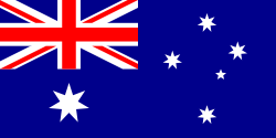 Queensland (Commonwealth of Australia), affiliated on October 27, 1984
 Ohio (United States), affiliated on October 22, 1990
 Brandenburg (Federal Republic of Germany), affiliated on August 26, 1998
Sports
The sports teams listed below are based in Saitama.
Football (soccer)
Baseball
- Saitama Seibu Lions (Tokorozawa)
Basketball
- Saitama Broncos (Tokorozawa)
Volleyball
- Takefuji Bamboo (Kitakatsushika District)
Rugby
- Secom Rugguts (Sayama)
Tourism
Most of the popular tourist sites in Saitama are located in the northwestern part of the prefecture, which is known as the Chichibu Region. This region mostly consists of a hilly and moderately mountainous area, and is situated in a rich natural environment. The region is very popular among residents of Saitama and neighboring prefectures for short trips, as it is easily accessible via the railroad network.
Visitor attractions
|
|
Events

- Chichibu Night Festival (秩父夜祭)
This festival is held by Chichibu Shrine annually on 2 December and 3 December, and has been held for more than 300 years. It is famous for the parade of six traditional wooden floats (each one weighing more than 10 tons), and is counted as one of the three big traditional float festivals in Japan (along with Gion Festival (祇園祭) in Kyoto and Hida-Takayama Festival (飛騨高山祭) in Takayama, Gifu).
Mascot
- Kobaton (コバトン) is the prefectural mascot, a Eurasian collared dove, which is also the prefectural bird. Kobaton was made originally as the mascot of the fifty- ninth annual national athletic meeting held in the prefecture in 2004, and was inaugurated as mascot of the prefecture in 2005 with an inauguration ceremony and a letter of appointment from the governor. A wheelchair-using version of Kobaton also exists. [4]
References
Notes
- ↑ [ http://ja.wikipedia.org/wiki/%E5%9F%BC%E7%8E%89%E7%9C%8C#.E5.9C.B0.E7.90.86]
- ↑ [1]
- ↑ [ http://www.pref.saitama.lg.jp/A08/BG00/kasen/koumoku/kasen2.html]
- ↑ [ http://ja.wikipedia.org/wiki/%E5%9F%BC%E7%8E%89%E7%9C%8C]
- ↑ Connecting TOKYO and Narita Int'l Airport - NARITA HELI EXPRESS
- ↑ 航空自衛隊入間基地
- ↑ 航空自衛隊熊谷基地
- ↑ ja:赤岩渡船 as of 2007-05-24T12:50.
- ↑ [2] as of 2007-06-20.
- ↑ ja:荒川 (関東)#荒川にまつわる話題, as 2007-06-12日T11:57.
External links
|
|||
| Saitama City | |||
|---|---|---|---|
| Chūō-ku | Iwatsuki-ku | Kita-ku | Midori-ku | Minami-ku | Minuma-ku | Nishi-ku | Ōmiya-ku | Sakura-ku | Urawa-ku | |||
| Cities | |||
| Ageo | Asaka | Chichibu | Fujimi | Fujimino | Fukaya | Gyōda | Hannō | Hanyū | Hasuda | Hatogaya | Hidaka | Higashi-Matsuyama | Honjō | Iruma | Kasukabe | Kawagoe | Kawaguchi | Kazo | Kitamoto | Koshigaya | Kōnosu | Kuki | Kumagaya | Misato | Niiza | Okegawa | Saitama (capital) | Sakado | Satte | Sayama | Shiki | Sōka | Toda | Tokorozawa | Tsurugashima | Wakō | Warabi | Yashio | Yoshikawa | |||
| Districts | |||
| Chichibu | Hiki | Iruma | Kita-Adachi | Kita-Katsushika | Kita-Saitama | Kodama | Minami-Saitama | Ōsato | |||
|
|
|||||||||||