Saitama, Saitama
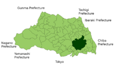 Saitama's location in Saitama Prefecture, Japan. |
|
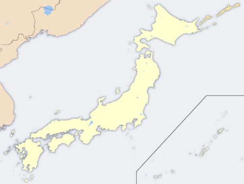 Saitama's location in Japan. |
|
| Location | |
| Country | Japan |
| Region | Kantō |
| Prefecture | Saitama Prefecture |
| Physical characteristics | |
| Area | 217.49 km2 (83.97 sq mi) |
| Population (as of July 1, 2006) | |
| Total | 1,182,115 |
| Density | 5,435 /km² (14,077 /sq mi) |
| Location | |
| Symbols | |
| Tree | Zelkova serrata(Keyaki) |
| Flower | Primula(Sakura-sou) |
 Flag |
|
| Saitama Government Office | |
| Mayor | Sōichi Aikawa |
| Address | Saitama-shi, Urawa-ku Tokiwa, 6-4-4 330-9588 |
| Phone number | +81-48-829-1111 |
| Official website: Saitama City | |
Saitama (さいたま市 Saitama-shi?) is the capital and the most populous city of Saitama Prefecture in Japan, situated in the south-east of the prefecture. Its area incorporates the former cities of Urawa, Ōmiya, Yono and Iwatsuki. It is a city designated by government ordinance. Being in the Greater Tokyo Area and lying 15 - 30 kilometres north of central Tokyo, many of its residents commute into Tokyo.
Contents |
Geography
The city is located 20 to 30 km north of central Tokyo, roughly at the center of the Kantō Plain. Within Saitama Prefecture, the location corresponds to the southeastern portion bordered by Ageo City, Hasuda City, and Shiraoka Town to the north; Asaka City, Kawaguchi City, Toda City, and Warabi City to the south; Koshigaya City to the east; Kasukabe City to the northeast; and Kawagoe City, Shiki City, and Fujimi City to the west.
Situated within the Kantō Plain, the city is topographically comprised by lowlands and plateaus, mostly falling below 20 m above sea level, with no mountain ranges or hills within the city boundaries. The western portion of the city lies on the lowland created by the Arakawa River along with those created by small rivers such as the Moto-Arakawa River, Shiba River, and Ayase River. The rest of the area mostly resides on the Ōmiya Plateau lying in the north-south direction. Dispersed in this region, major rivers flow southward, almost paralleling to one another. [1]
Wards

Saitama has ten wards (ku), which were assigned official colours as of April 2005:
| ■1 - Chūō-ku | 中央区 | (Rose red) |
| ■2 - Iwatsuki-ku | 岩槻区 | (Ochre) |
| ■3 - Kita-ku | 北区 | (Dark green) |
| ■4 - Midori-ku | 緑区 | (Green) |
| ■5 - Minami-ku | 南区 | (Lemon yellow) |
| ■6 - Minuma-ku | 見沼区 | (Sky blue) |
| ■7 - Nishi-ku | 西区 | (Blue) |
| ■8 - Ōmiya-ku | 大宮区 | (Orange) |
| ■9 - Sakura-ku | 桜区 | (Cherry blossom pink) |
| ■10 - Urawa-ku | 浦和区 | (Red) |
Economy

The economy of the city is basically as one of the commercial centres in the Greater Tokyo Area and as a business centre to serve Saitama Prefecture, North Kantō or northeast Honshū.
Agriculture there is to supply foods for the residents of Greater Tokyo.
Manufacturing includes automotive, food, optical, precision and pharmaceutical products. Iwatsuki is famous for manufacturing of hinamatsuri dolls and ornate kabuto (samurai helmets). Biotechnology is an important industry in the city.
Transportation
- Further information: Transportation in Greater Tokyo
Saitama is a regional transportation hub for both passengers and freight.
Ōmiya Station, part of the Shinkansen high-speed train network, serves as the biggest railway hub in the prefecture. The Musashino and Saitama Railway lines offer connections at other stations. The Shuto, Tokyo Gaikan and Tōhoku expressways serve the city. National Highway Routes 16, 17, 122, 298 and 463 also serve the city.
The closest major airports are Haneda Airport and Narita International Airport, both about two hours away[2]. Honda Airport in Okegawa is for general aviation and offers no scheduled transport services. Commuter helicopter flights to Narita Airport are offered from Kawajima [1].
Politics and Government
The directly-elected, executive mayor is Sōichi Aikawa, an independent backed by the Liberal Democratic Party and Komeito. The city assembly of Saitama has 64 elected members.
Elections
- Saitama mayoral election, 2005
Culture
Education
Universities
- Mejiro University
- Nihon University Faculty of Law
- The Open University of Japan Omiya Study Center
- Saitama University
- Shibaura Institute of Technology
- University of Human Arts and Sciences
- Urawa University
Junior Colleges
- Kokusai Gakuin Saitama Junior College
- Urawa University Junior College
High Schools
- Urawa High School
- Urawanishi High School
Professional Graduate School
Omiya Law School
Sports
Saitama is home to two J. League football (soccer) teams: the popular Urawa Red Diamonds, formerly owned by Mitsubishi, and Omiya Ardija, formerly owned by NTT.
The city and Tokorozawa are home to the Japan Professional Basketball League team the Saitama Broncos.
Mass media
Most of Saitama Prefecture's mass media presence is concentrated in this city. See Mass media in Saitama Prefecture for details.
History
The city was founded on May 1, 2001, and was designated on April 1, 2003 as a government ordinance. For the histories of Urawa, Ōmiya and Yono before the merger, see Urawa-ku, Saitama#History, Ōmiya-ku, Saitama#History and Yono, Saitama#History, respectively.
On April 1, 2005, it merged with the city of Iwatsuki to its east, which became a new ward, Iwatsuki-ku.
Origin of the name "Saitama"
The name "Saitama" originally comes from the Sakitama (埼玉郡) district of what is now the city of Gyōda in the northern part of what is now known as Saitama Prefecture. "Sakitama" has an ancient history and is mentioned in the famous 8th century poetry anthology Man'yōshū. The pronunciation has changed from Sakitama to Saitama over the years.
With the merger of Urawa, Ōmiya, and Yono it was decided that a new name, one fitting for this newly-created prefectural capital, was needed. The prefectural name "Saitama" (埼玉県) was changed from kanji into hiragana, thus Saitama City (さいたま市) was born. It is the only prefectural capital in Japan whose name is always written in hiragana, and belongs to the list of hiragana cities.
However, Saitama written in hiragana (さいたま市) actually finished in second place in public polling to Saitama written in kanji (埼玉市). Despite this, government officials decided to name the new city Saitama in hiragana, not kanji. In third place in the poll was Ōmiya (大宮市). In fourth was Saitama (彩玉市), written with an alternative kanji for "sai" (彩) which means "colorful". The "sai" (埼) used in the prefectural name is a rare form of a common character (崎) that means cape or promontory.
Sister cities
Saitama has six sister cities.
 Toluca, Mexico (1979)
 Zhengzhou, China (1981)
 Hamilton, New Zealand (1984)
 Richmond, Virginia, United States (1994)
 Nanaimo, British Columbia, Canada (1996)
- Pittsburgh, Pennsylvania, United States (1998)
Visitor attractions
- Akigase Park
- Besshonuma Park
- Hikawa Shrine
- John Lennon Museum
- Minuma
- Railway Museum
- Sonic City
- Saitama Stadium 2002
- Saitama Super Arena
External links
- Official website in Japanese
- Official website in English
|
|||
| Saitama City | |||
|---|---|---|---|
| Chūō-ku | Iwatsuki-ku | Kita-ku | Midori-ku | Minami-ku | Minuma-ku | Nishi-ku | Ōmiya-ku | Sakura-ku | Urawa-ku | |||
| Cities | |||
| Ageo | Asaka | Chichibu | Fujimi | Fujimino | Fukaya | Gyōda | Hannō | Hanyū | Hasuda | Hatogaya | Hidaka | Higashi-Matsuyama | Honjō | Iruma | Kasukabe | Kawagoe | Kawaguchi | Kazo | Kitamoto | Koshigaya | Kōnosu | Kuki | Kumagaya | Misato | Niiza | Okegawa | Saitama (capital) | Sakado | Satte | Sayama | Shiki | Sōka | Toda | Tokorozawa | Tsurugashima | Wakō | Warabi | Yashio | Yoshikawa | |||
| Districts | |||
| Chichibu | Hiki | Iruma | Kita-Adachi | Kita-Katsushika | Kita-Saitama | Kodama | Minami-Saitama | Ōsato | |||
|
|
|||||||||||