Saarbrücken
| Saarbrücken | |
 |
|
| Coat of arms | Location |
 |
 |
| Administration | |
| Country | Germany |
|---|---|
| State | Saarland |
| District | Regionalverband Saarbrücken |
| City subdivisions | 20 |
| Mayor | Charlotte Britz (SPD) |
| Basic statistics | |
| Area | 167.07 km² (64.5 sq mi) |
| Elevation | 230.1 m (755 ft) |
| Population | 180,515 (30/12/2006) |
| - Density | 1,080 /km² (2,798 /sq mi) |
| Other information | |
| Time zone | CET/CEST (UTC+1/+2) |
| Licence plate | SB |
| Postal codes | 66001-66133 |
| Area codes | 0681, 06893, 06897, 06898, 06805 |
| Website | www.saarbruecken.de |
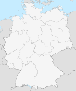
| Location of the town of Saarbrücken within Regionalverband Saarbrücken district | |
|
|||||||||||||||||||||||||||||
Saarbrücken (pronounced [ˈzaːɐ̯ˈbrʏkn] in German; French: Sarrebruck) is the capital of the state of Saarland in Germany. The city sits at the heart of a metropolitan area that bounds westwards to Dillingen and northeastwards to Neunkirchen, in which most of the people of the Saarland live.
Saarbrücken used to be the industrial and transport centre of a great coal basin; factories here produced iron and steel, sugar, beer, pottery, optical instruments, machinery, and construction materials. However, over the past decades the industrial importance of Saarland has declined, as it is much cheaper, even for German companies, to import coal from lower-wage countries instead of buying it here.
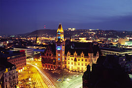
Historic landmarks in the city include the stone bridge across the Saar (1546), the Gothic church of St Arnual, the 18th century Saarbrücker Schloss (castle) and the old part of the town, the St. Johanner Markt. In 1815 Saarbrücken came under Prussian control, and for two periods in the 20th century (1919–35 and 1945–57) it became part of the Saar territory under French administration. For this reason, coupled with its proximity to the French border, it retains a certain French influence.
In modern German Saarbrücken literally means Saar bridges, and indeed there are about a dozen bridges across the Saar river. However the name actually predates any bridge at this spot by at least 500 years . The historical name of the town is actually Sarabrucca, derived from the Old High German word Brucca, which became Brocken in High German (rocks or boulders in English) .
Contents |
History
Roman Empire
The Saar area was incorporated into the Roman Empire in the 1st century BC, and later came under the control of the Franks. In 925 it became part of the Holy Roman Empire, but a strong French influence continued.
Middle Ages to 18th century
From 1381 to 1793 the counts of Nassau-Saarbrücken were the main local rulers. Often a prize contended for by its stronger neighbours, the area came under French domination in the 16th century and was incorporated into France in the 1680s. France was forced to relinquish the Saar in 1697, but from 1793 to 1815 regained control of the region.
19th century
After 1815 much of the area was part of the Prussian Rhine Province. During the 19th century the coal and iron resources of the region were developed. At the start of the Franco-Prussian War the area was the first target of the French invasion force, and was occupied between August 2 and August 4 1870, during this war.
20th century
Under the Treaty of Versailles (1919) the Saar coal-mines were made the exclusive property of France for a period of 15 years as compensation for the destruction of French mines during the First World War. The treaty also provided for a plebiscite, at the end of the 15-year period, to determine the territory's future status, and in 1935 more than 90% of the electorate voted for reunification with Germany, while only 0.8% voted for unification with France. The remainder voted for maintenance of the League of Nations administration. The Saar subsequently rejoined Germany.
World War II
Heavily bombed in World War II and made part of the French Zone of Occupation in 1945, the area was made a separate zone in 1946. In 1947, France created the nominally–politically-independent Saar protectorate and merged it economically with France in order to exploit the area's vast coal reserves. Political pressure on France by West Germany and others, as well as the 1955 rejection by the Saarlanders of the compromise solution of Europeanisation of the area, led to the January 1, 1957 political reunion with the Federal Republic of Germany. Economic reintegration would however take many additional years.
Infrastructure
The city is served by the Saarbrücken Airport (SCN) and starting in June 2007 ICE high speed train services along the LGV Est line provide high speed connections to Paris. Uniquely, Saarbrücken's Saarbahn (modelled on the Karlsruhe model light rail) crosses the French–German border, connecting to the French city of Sarreguemines
Saarbrücken is also the home of the main campus of Saarland University (Universität des Saarlandes). Co-located with the University are several research centres focusing on computer science, materials science, biomedical technology and European studies.
Geography
Climate
| for Saarbrücken | |||||||||||||||||||||||||||||||||||||||||||||||
|---|---|---|---|---|---|---|---|---|---|---|---|---|---|---|---|---|---|---|---|---|---|---|---|---|---|---|---|---|---|---|---|---|---|---|---|---|---|---|---|---|---|---|---|---|---|---|---|
| J | F | M | A | M | J | J | A | S | O | N | D | ||||||||||||||||||||||||||||||||||||
|
54
3
-1
|
42
4
-1
|
38
9
-2
|
38
13
4
|
46
18
8
|
49
21
11
|
50
23
13
|
40
23
13
|
39
19
10
|
52
14
7
|
59
7
2
|
61
4
0
|
||||||||||||||||||||||||||||||||||||
| temperatures in °C precipitation totals in mm source: worldweather.org 2007-12-01 |
|||||||||||||||||||||||||||||||||||||||||||||||
|
Imperial conversion
|
|||||||||||||||||||||||||||||||||||||||||||||||
Region
Some of the closest big cities are Trier, Luxembourg, Nancy, Metz, Kaiserslautern, Karlsruhe and Mannheim. Saarbrücken is also connected by the city's public transport network to the town of Sarreguemines in France, allowing easy crossing of the border between one country and the other. It is also connected to the satellite town of Völklingen, where the old steel works were the first industrial monument to be declared a World Heritage Site by UNESCO in 1994 — the Völklinger Hütte.
Sister cities
Famous People
- Max Ophüls (May 6 1902 - March 25 1957), film director
- Wolfgang Staudte (October 9 1906 - January 19 1984), film director
- Walter Schellenberg (January 16 1910 – March 31 1952), German Nazi (head of Foreign intelligence)
- Gerhard Schröder (September 11 1910 - December 31 1989), politician
- Otto Steinert (July 12 1915 – March 3 1978), photographer
- Frederic Vester (November 23 1925 - November 2 2003), biochemist
- Frédéric Back (April 8 1924), Canadian animator
- Tzvi Avni (September 2 1927), Israeli composer
- Sandra Cretu (May 18 1962), singer
- Claudia Kohde-Kilsch (December 11 1963), tennis player
- Nicole (October 25 1964), singer
- Manfred Trenz (November 29 1965), game designer
- Andreas Escher (January 23 1966), game designer
Honorary citizen
- Willi Graf (January 2 1918 - October 12 1943), member of the White Rose resistance group
Gallery
External links
|
|||||||