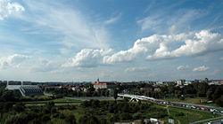
Rzeszów
| Rzeszów | |||
 |
|||
|
|||
 Rzeszów
|
|||
| Coordinates: | |||
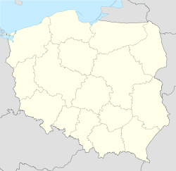
| Country | |||
|---|---|---|---|
| Voivodeship | |||
| County | city county | ||
| Town rights | 1354 | ||
| Government | |||
| - Mayor | Tadeusz Ferenc | ||
| Area | |||
| - City | 91.54 km² (35.3 sq mi) | ||
| Population (2008) | |||
| - City | 170,722 | ||
| - Density | 1,865/km² (4,830.3/sq mi) | ||
| - Metro | 740,000 | ||
| Time zone | CET (UTC+1) | ||
| - Summer (DST) | CEST (UTC+2) | ||
| Postal code | 35-000 to 35-900 | ||
| Area code(s) | +48 17 | ||
| Car plates | RZ | ||
| Website: http://www.erzeszow.pl/ | |||


Rzeszów [ˈʐɛʂuf] (![]() listen) (Ukrainian: Ряшiв, German: Reichshof (1941-45), Latin: Resovia, Yiddish: ריישע-Reisha) is a city in south-eastern Poland with a population of 171,330 inhabitants, as of 30.06.2008.[1] It was granted a town charter in 1354, the capital and largest city of the Subcarpathian Voivodeship (since 1999), previously of Rzeszów Voivodeship (1945–1998).
listen) (Ukrainian: Ряшiв, German: Reichshof (1941-45), Latin: Resovia, Yiddish: ריישע-Reisha) is a city in south-eastern Poland with a population of 171,330 inhabitants, as of 30.06.2008.[1] It was granted a town charter in 1354, the capital and largest city of the Subcarpathian Voivodeship (since 1999), previously of Rzeszów Voivodeship (1945–1998).
Rzeszów is served by an international airport, is a member of Eurocities, and is home to a number of large universities, company headquarters, and foreign consulates.
Contents |
Location
Rzeszów is located on both sides of the Wisłok river. It is located in the heartland of the Sandomierska valley. Rzeszów is also the capital of the Subcarpathian Voivodeship, and seat of the Rzeszów County.
History
Rzeszów was founded in 1354 by king Casimir III of Poland. For a long time it was just a domain of the noble family of Lubomirski, one of the most important in Poland. Besides having a famous annual market, Rzeszów remained only another city on the trade route to Hungary. In 1658 Jerzy Sebastian Lubomirski established the Piarist school, the second secondary school in Poland. During the XIX century Rzeszów began to lose significance in favour of Przemyśl. Development of Rzeszów started when in 1937 military industry was located in the city: Państwowe Zakłady Lotnicze, producing aircraft engines, and a cannon factory – a branch of Hipolit Cegielski factory.
Until on the outbreak of World War II the Jews of Rzeszów numbered 15,000, more than one-third of the total population. The town was occupied by the German Army on 10 September 1939. German persecution of the Jews of began almost immediately, by the end of 1939, there were 10 forced labour camps in the Rzeszów region and many Jews became slave labourers in the region. Jewish were forced to live in the Gestapo controlled ghetto. Many Jews managed to flee to Soviet occupied Poland. By June 1940, the number of Jews in Rzeszów had decreased to 11,800, of whom 7,800 were pre-war residents of the city the rest were refugees from surrounding villages. Life in the ghetto was impossible and hundreds died. During WWII some 20,000 Jews were murdered in the ghetto in Rzeszów. This number includes thousands who were sent to Rzeszów only to be deported or murdered soon after arrival. Of 15,000 Rzeszów Jews, merely 100 survived the war; in Rzeszów itself, in hiding all over Poland, and in various camps. After the war an additional 600 Rzeszów Jews returned from the Soviet Union. Almost all of them subsequently left the city and the country.
In 2004, Rzeszów hosted the Central European Olympiad in Informatics (CEOI).
Education
Universities:
- Rzeszów University (established in 2001 from a number of smaller schools)
- Rzeszów University of Technology (formed from The Higher Engineering School in 1974) website
- University of Information Technology and Management (established in 1996) website
- Branches in Dębica, Krosno and Nisko
- Wyższa Szkoła Zarządzania
- Wyższa Szkoła Administracji i Zarządzania in Przemyśl, branch in Rzeszów (established in 1995) website
Notable High Schools:
- Konarski's Number 1 High School in Rzeszów

Transport
Transit
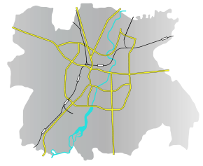
Ropczyce is located on the main ![]() West-East European E40 Highway, which goes from Calais in France via Belgium, across Germany, Poland, Ukraine and onto Russia and Kazakhstan. Traffic is therefore high, but as the city has a ring road through its southern districts, transit does not have to pass through the city centre. Other Polish cities located by the E40 highway are Wrocław, Opole, Katowice, Kraków, Tarnów, Dębica, Ropczyce and Przemyśl.
West-East European E40 Highway, which goes from Calais in France via Belgium, across Germany, Poland, Ukraine and onto Russia and Kazakhstan. Traffic is therefore high, but as the city has a ring road through its southern districts, transit does not have to pass through the city centre. Other Polish cities located by the E40 highway are Wrocław, Opole, Katowice, Kraków, Tarnów, Dębica, Ropczyce and Przemyśl.
In recent years, communication has been improved by modernisation of the roads within the city. SCATS traffic system has been implemented.
Highway A4 is planned to be built as a beltway of the city, running through the northern districts of Rzeszów.
Airport
Rzeszów-Jasionka Airport (Port Lotniczy Rzeszów-Jasionka) is located in the village of Jasionka north of the city. Scheduled passenger services include flights to: Warsaw (WAW), Dublin, London (Stansted), Bristol, UK, Birmingham, UK, New York (JFK Airport, and Newark Liberty International Airport).
Buses
The city operates 49 bus lines including night and airport buses. Rzeszów is also a gateway to Bieszczady mountains, many buses heading for Sanok.
Railway
Rzeszów is a stop on the main railway from Silesia to the Polish eastern border and further on to Ukraine. Its main railway station was established in the XIX. century. There is also a unique, non-electrified railway to Jasło.
Culture

Theaters
- Theatre of Wanda Siemaszkowa (est. 1944)
- Theatre Maska
Museums
- Etnographic Museum
- Museum of the City of Rzeszów
- Diocesan Museum
Other
- Philharmonic Hall of Artur Malawski
Economy
Industry
- Valeant Pharmaceuticals International (NYSE:VRX) Rzeszów (formerly ICN Polfa Rzeszów)
- United Technologies Corporation (NYSE:UTX) Pratt & Whitney division - Aerospace engineering including one of world's two F-16 engine manufacturers
- Zelmer SA - household equipment
- Asseco Poland SA (earlier Comp Rzeszów S.A) - computer software
- Novartis International AG (NYSE:NVS) Rzeszów - Gerber Products Company food production facilities
- Sanofi-Aventis (NYSE:SNY)
At Widelka substation, situated approximately 20 kilometres northnortheast of Rzeszów, the only 750 kV powerline in Poland, coming from Khelmitiskaja in Ukraine ends.
Tourist attractions

- palace of Lubomirski family from XVIII cent.
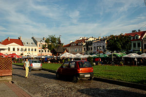
- main square
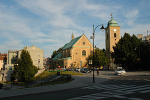
- town hall, established in 1591
- synagogues: "Small" (XVII cent.), "Big" (XVIII cent., restored 1954-63)
- Łańcut palace
- Podziemia, underground tunnel.
Sports
- Resovia Rzeszów - the oldest team in Poland (1905 or 1904) men's volleyball team playing in Polish Volleyball League (Polska Liga Siatkówki, PLS: Seria B in 2003/2004, Seria A in 2004/2005 season).
- Stal Rzeszów - men's football team (Polish Cup winner 1975)
- Marma Rzeszów - motorcycle speedway Ekstraliga team
Notable People
As the largest city of the region Rzeszów has a diverse set of notable people associated with it. Singer Justyna Steczkowska, general Józef Zając, and leading theater director Jerzy Grotowski, among others, were born in the city. Polish prime minister and commander-in-chief general Władysław Sikorski studied there while the pioneer of the oil industry Ignacy Łukasiewicz spent much of his life in Rzeszów. Renowned Polish jazz trumpet player Tomasz Stanko is also from Rzeszów.
Media
Radio
- Radio Rzeszów
- Radio Eska Rzeszów
- Akademickie Radio Centrum
- Katolickie Radio Via
- Radio RES
Press
- Gazeta Codzienna NOWINY
- Super Nowości
Television
- Polish Television (TVP) branch in Rzeszów
- Rzeszów's cable television
- Local television Vectra (old DAMI)
- Municipal television Rzeszów
Sister Cities/Twin Towns
Rzeszów is twinned with
|
References
- ↑ "Central Statistical Office(GUS) - Polish Official Census 2008".
 (in Polish) (30.06.2008). Retrieved on 2008-11-01.
External links
- Gallery
- Rzeszów City Department
- Welcome to Rzeszów!
- Gallery of Rzeszów
- Rzeszów - a printable PDF guide
|
|||||||
|
||||||||||
|
|||||||
