Ruhr
| Ruhr | |
|---|---|
 |
|
| Origin | Sauerland |
| Mouth | Rhine |
| Basin countries | Germany |
| Length | 217 km |
| Source elevation | 674 m |
| Avg. discharge | 79 m³/s |
| Basin area | 4,485 km² |
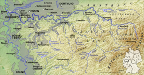
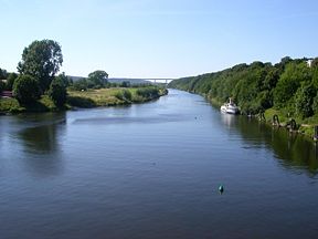
The Ruhr is a medium-size river in western Germany (North Rhine-Westphalia), a right tributary (east-side) of the Rhine. Its source is at an elevation of approximately 2,200 feet (670 m), near the town of Winterberg in the mountainous Sauerland region, and it flows into the lower Rhine river at an elevation of only 56 feet (17 m) in the municipal area of Duisburg. Its total length is 217 km (135 miles), its average discharge is 79 m³/s (cubic metres per second) at Mülheim near its mouth. Thus, its discharge is, for example, comparable to that of the Ems river in Northern Germany or the Thames river in the United Kingdom.
Towns
The Ruhr first passes the towns of Meschede, Arnsberg, Wickede, Fröndenberg, Holzwickede, Iserlohn and Schwerte.
Then the river marks the southern limit of the Ruhr area, passing Hagen, Dortmund, Herdecke, Wetter, Witten, Bochum, Hattingen, Essen, Mülheim and Duisburg.
The Ruhr Area was Germany's main industrial zone during the early 1900s. Most factories were located there. Occupation of the Ruhr in the 1920s by French forces caused Passive Resistance, which saw production in the factories grind to a halt. As a result, the hyperinflation crisis grew even worse.
Lakes
There are five Ruhr reservoirs on the river, often used for leisure activities.
- Hengsteysee between Dortmund and Hagen, Area of the surface: 1.36km² height of the weir 4.5m
- Harkortsee between Hagen Herdecke and Wetter; Area of the surface: 1.37km², height of the weir 7.8m
- Kemnader See between Witten and Bochum; Area of the surface: 1.25 km², height of the weir 2m
- Baldeneysee in Essen-Werden; Area of the surface: 2.64 km², height of the weir 8.5m
- Kettwiger See in Essen-Kettwig; Area of the surface: 0.55 km², height of the weir 6m
The adjacent major industrial region adopted its name from this river.
The Ruhr is used for the preparation of drinking water and has a good water quality, which contains a certain linguistic irony, since the word "Ruhr" means dysentery in the German language. Its riversides are largely characterized by open spaces and parkland, thus being used as recreation areas.

See also
|
||||||||||
