Rotorua
| Rotorua Rotorua-nui-a-Kahu (Maori) |
|
 |
|
| Country | |
|---|---|
| Region | Bay of Plenty |
| Territorial authority | Rotorua District |
| Settled | pre-European |
| Founded | 1883 |
| Borough status | 1922 |
| City status | 1962 |
| Electorate | Rotorua |
| Government | |
| - MP | Steve Chadwick (Labour) |
| - Mayor | Kevin Winters |
| Area | |
| - Territorial | 2,614.9 km² (1,009.6 sq mi) |
| Population (June 2008 estimate)[1] | |
| - Territorial | 68,000 |
| - Density | 26/km² (67.4/sq mi) |
| - Urban | 55,600 |
| Time zone | NZST (UTC+12) |
| - Summer (DST) | NZDT (UTC+13) |
| Postcode(s) | 3010, 3015 |
| Area code(s) | 07 |
| Local iwi | Te Arawa, Ngāti Ranginui |
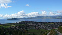
Rotorua is a city on the southern shore of Lake Rotorua in the Bay of Plenty region of the North Island of New Zealand, and Rotorua District is the encompassing local authority area. The city has a population of 55,600, the district 68,000[1]. It is 60 km south of Tauranga, 105 km south-east of Hamilton and 82 km north-east of Taupo. The District is divided between the Bay of Plenty (61.52 percent of its land area) and the Waikato (38.48 percent) Regions. Rotorua's suburbs are Ngongotaha, Fairy Springs, Selwyn Heights, Kawaha Point, Western Heights, Pukehangi, Pleasant Heights, Mangakakahi, Sunnybrook, Pomare, Utuhina, Ohinemutu, Koutu, Hillcrest, Matipo Heights, Glenholme, Fordlands, Springfield, Rotorua West, Fenton Park, Whakarewarewa, Waipa Village, Tihiotonga, Ngapuna, Lynmore, Te Ngae, Owhata, Hannahs Bay, Holdens Bay and Rotokawa.
Rotorua is well-known for geothermal activity. There are a number of geysers, notably the Pohutu geyser at Whakarewarewa, and hot mud pools located in the city, which owe their presence to the Rotorua caldera.
Rotorua won the "New Zealand's Most Beautiful City Award" in 2002 and 2006.[2]
Rotorua is connected to the north by State Highway 5, to the east by State Highway 33, to the west by State Highway 30, and to the south by State Highway 5. Increasingly though travellers to Tauranga are selecting the newly commissioned State Highway 36 via Ngongotaha, Kaharoa and Pyes Pa.
Rotorua Regional Airport provides daily flights to Auckland International Airport and Wellington International Airport via turbo-prop services and Christchurch International Airport using turbo-props and a daily jet service. Plans are afoot to increase the runway length to allow trans-Tasman flights.
Rotorua is also connected to the rail network with a branch line from Putaruru to the north, currently disused.
Rotorua is also home to the largest tertiary institute outside of the university centres, Waiariki Institute of Technology.
Rotorua has its own regional television channel, TV Rotorua.
Contents |
History


The name Rotorua comes from Māori, the full name being Te Rotorua-nui-a-Kahumatamomoe; roto means lake and rua two - Rotorua thus meaning 'Second lake'. Kahumatamomoe was the uncle of the Māori chief Ihenga, the ancestral explorer of the Te Arawa.[3] It was the second major lake the chief discovered, and he dedicated it to his uncle. It is the largest of a multitude found to the north-east of the city, all connected with the Rotorua Caldera and nearby Mount Tarawera. The name can also mean the equally appropriate 'crater lake'.[3]
The area was initially settled by Māori of the Te Arawa iwi. The first European in the area was probably Phillip Tapsell who was trading from the Bay of Plenty coast at Maketu from 1828. He later married into Te Arawa and became highly regarded by them.[4] Missionaries Henry Williams and Thomas Chapman visited in 1831[3] and Chapman and his wife established a mission at Te Kouto in 1835.[5] This was abandoned within a year but Chapman returned in 1838 and established a second mission at Mokoia Island.[5][3]
The lakeshore was a prominent site of skirmishes during the New Zealand Wars of the 1860s. A "special town district" was created in the 1883, in order to promote Rotorua's potential as a spa. The town was connected to Auckland with the opening of the Rotorua Branch railway and commencement of the Rotorua Express train in 1894, resulting in the rapid growth of the town and tourism from this time forward. Rotorua was established as a borough in 1922 and declared a city in 1962 before becoming a District in 1979.
Geography
Climate
| Month | Jan | Feb | Mar | Apr | May | Jun | Jul | Aug | Sep | Oct | Nov | Dec | Year |
|---|---|---|---|---|---|---|---|---|---|---|---|---|---|
| Average high °C (°F) | 23 (73) |
23 (73) |
21.1 (70) |
18.3 (65) |
15.1 (59) |
12.6 (55) |
12.1 (54) |
13 (55) |
14.7 (58) |
16.7 (62) |
19 (66) |
20.9 (70) |
17.5 (64) |
| Average low °C (°F) | 12.7 (55) |
12.9 (55) |
11.6 (53) |
8.8 (48) |
5.9 (43) |
4.2 (40) |
3.1 (38) |
4.4 (40) |
6 (43) |
7.9 (46) |
9.6 (49) |
11.3 (52) |
8.2 (47) |
| Precipitation mm (inches) | 99 (3.9) |
101 (3.98) |
115 (4.53) |
112 (4.41) |
104 (4.09) |
134 (5.28) |
130 (5.12) |
148 (5.83) |
119 (4.69) |
122 (4.8) |
102 (4.02) |
115 (4.53) |
1,401 (55.16) |
| Source: NIWA Climate Data[6] 1971 – 2000 | |||||||||||||
Geothermal areas
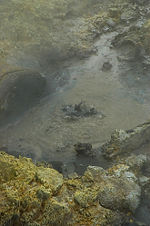


Thermal activity is at the heart of much of Rotorua's tourist appeal. Geysers and bubbling mud-pools, hot thermal springs and the Buried Village (Te Wairoa) - so named after it was buried by the 1886 Mt Tarawera eruption - are within easy reach of the city.
Kuirau Park, to the west end of the central city, is also remarkable - hot bubbling mud pools dot the park, lending a surreal air to the setting. Visitors can soak their feet in hot pools.
Rotorua is nicknamed Sulphur City, because of the aforementioned thermal activity. The sulphur gives off an odour unique to Rotorua that adds to the visitor experience.
The especially pungent smell in the central-east 'Te Ngae' area is due to the dense sulphur deposits located next to the southern boundary of the Government Gardens, in the area known as 'Sulphur Point'.
Lakes
With 17 lakes, the Rotorua region is an aquatic paradise. Fishing, waterskiing, swimming and other water activities are popular in summer. The lakes are also great event venues; Rotorua hosted the 2007 World Waterski Championships. Lake Rotorua is also used as a departure and landing point for float planes.
Other activities
Rotorua is also home to botanical gardens and interesting historic architecture. Known as a spa town and major tourist resort since the 1800s, many of its buildings hint at this history. Government Gardens, close to the lakeshore at the eastern end of the town, are particularly worthy of note.
Another of Rotorua's attractions is the mountain biking. Whakarewarewa (also known as the "Redwoods") Forest has been described as 'the Disneyland of mountain biking' and has some of the best mountain bike trails in New Zealand. Rotorua hosted the UCI Mountain Bike and Trials World Championships, in August 2006.
Famous people
- Jean Batten
- Susan Devoy
- Alan Duff
- Bevan Hari
- Tame Iti
- David Kosoof
- Danny Lee
- Elizabeth Marvelly
- Sir Howard Morrison
- Temuera Morrison
- Christopher Perkins
- Wayne "Buck" Shelford
- Miriama Smith
- Peter Tapsell
- Cliff Curtis
- Michael Barker (drummer)
- Liam Messam, rugby union player for Waikato
- Julian Dean, road racing cyclist
- Sam Bewley, NZ bronze medalist in cycling.
Sister cities
Rotorua has four sister cities:
 Klamath Falls, Oregon, USA[7]
 Beppu, Kyūshū, Japan
 Lake Macquarie, New South Wales, Australia
 Wuzhong, Suzhou, China
TV
The free-to-air TV stations received in Rotorua come from the Pukepoto transmitter. They are broadcast on the following frequencies:
| Free-to-air TV Frequencies | ||||
|---|---|---|---|---|
| Channel Name | Transmit Channel | Polarization | Frequency (MHz) | Band |
| TV One | 5 | Horizontal | 182.25 | VHF |
| TV2 | 7 | Horizontal | 196.25 | VHF |
| C4 | 9 | Horizontal | 210.25 | VHF |
| TV3 | 11 | Horizontal | 224.25 | VHF |
| iTV Live | 29 | Vertical | 535.25 | UHF |
| Prime | 33 | Vertical | 567.25 | UHF |
| TAB Trackside | 47 | Vertical | 679.25 | UHF |
| Maori Television | 51 | Vertical | 711.25 | UHF |
| TV Rotorua | 59 | Vertical | 775.25 | UHF |
References
- ↑ 1.0 1.1 "Subnational Population Estimates: At 30 June 2008". Statistics New Zealand (23 October 2008). Retrieved on 2008-10-28.
- ↑ Keep Rotorua Beautiful - Litter Control
- ↑ 3.0 3.1 3.2 3.3 Wises New Zealand Guide, 7th Edition, 1979. p383.
- ↑ New Zealand Encyclopaedia 1966: Tapsell Biography
- ↑ 5.0 5.1 New Zealand Dictionary of Biography: Thomas Chapman
- ↑ "Climate Data". NIWA. Retrieved on November 2, 2007.
- ↑ Sister Cities International
External links
- Official Rotorua Website
- Official Rotorua YouTube channel
- Visitor Information TV & Website
- TV Rotorua
- Glorious Mud: A Tourist's Introduction to Rotorua
- Rotorua Street Maps
- Mountain Biking in Rotorua
- Rotorua travel guide from Wikitravel
|
|||||||||||||||||