Rondônia
|
State of Rondônia
|
||||||
|---|---|---|---|---|---|---|
|
||||||
 |
||||||
| Capital (and largest city) |
Porto Velho | |||||
| Demonym | Rondoniano or Rondoniense | |||||
| Government | ||||||
| - | Governor | Ivo Cassol | ||||
| - | Vice Governor | João Cahulla | ||||
| Population | ||||||
| - | 2006 estimate | 1,562,417 (23th) | ||||
| - | 2005 census | 1,537,072 | ||||
| GDP | 2005 estimate | |||||
| - | Total | R$ 12,902,000,000 (22th) | ||||
| - | Per capita | R$ 8,408 (13th) | ||||
| HDI (2005) | 0.776 (medium) (13th) | |||||
| Abbreviation | BR-RO | |||||
| Time zone | BRT (UTC-4) | |||||
| - | Summer (DST) | BRST (UTC-2) | ||||
Rondônia (pronounced [xõˈdõnia][1]) is a state in Brazil, located in the north-western part of the country. To the west is a short border with the state of Acre, to the north is the state of Amazonas, in the east is Mato Grosso, and in the south is Bolivia. Its capital is Porto Velho. The state was named after Candido Rondon. A boat ride on the Rio Madeira to appreciate the forest of centennial trees and the fauna of exotic birds is one of the best attractions of the State. Two thirds of its area is covered by the Amazon Rainforest. Other attractions are the Chapada dos Parecis and the Serra do Pacaás, a national park, and the capital, Porto Velho, plain and with few buildings.
Contents |
Geography

The state has a territory covered mostly by jungle of the Amazon Rainforest, but about three-fifths of the state has been deforested since intensive settlement and logging began in the 1970s, escalating even to this day. A majority of its citizens now live in urban areas. It is a main exporter of wood, as well as a significant producer of both coffee and cocoa, it is also an important cattle breeder.
Climate
An equatorial climate is a type of tropical climate in which there is no dry season – all months have mean precipitation values of at least 60mm. It is usually found at latitudes within five degrees of the equator – which are dominated by the Intertropical Convergence Zone. The equatorial climate is denoted Af in the Köppen climate classification. Tropical rainforest is the natural vegetation in equatorial regions.
Vegetation
About 70% of Rondônia are covered by the Amazon forest; the top of the "chapadas" is covered by savannahs (or cerrados, in Portuguese). Because of the fast growth of the population and economy, the forest zone of Rondônia is one of the most affected by human presence. The Amazon represents over half of the planet's remaining rainforests and comprises the largest and most species-rich tract of tropical rainforest in the world. Wet tropical forests are the most species-rich biome, and tropical forests in the Americas are consistently more species rich than the wet forests in Africa and Asia.[2] As the largest tract of tropical rainforest in the Americas, the Amazonian rainforests have unparalleled biodiversity. More than 1/3 of all species in the world live in the Amazon Rainforest.[3]
Demographics

According to the IBGE of 2007, there were 1,597,000 people residing in the state. The population density was 6.6 inh./km².
Urbanization: 66.8% (2004); Population growth: 2.2% (1991-2000); Houses: 430,747 (2005).[4]
The last PNAD (National Research for Sample of Domiciles) census revealed the following numbers: 934,000 Pardo (Brown) people (53.8%), 590,000 White (37.0%), 114,000 Black (7.2%), 35,000 Asian or Amerindian people (2.2%).[5]
Interesting facts
Vehicles: 337,089 (March/2007); Mobile phones: 730 thousand (April/2007); Telephones: 247 thousand (April/2007); Cities: 52 (2007).[6]
Economy
The service sector is the largest component of GDP at 54.1%, followed by the industrial sector at 30.6%. Agriculture represents 15.3% of GDP (2004). Rondônia exports: wood 83.6%, coffee 8.7%, granite 3.2%, frozen meat 3.1% (2002).
Share of the Brazilian economy: 0.6% (2005).
Education

Portuguese is the official national language, and thus the primary language taught in schools. But English and Spanish are part of the official high school curriculum.
Educational institutions
- Universidade Federal de Rondônia (Unir) (Federal University of Rondônia);
- Escola Agrotécnica Federal de Colorado do Oeste (EAFCO);
- Instituto Luterano de Ensino Superior de Porto Velho (Iles-Ulbra);
- Faculdade de Ciências Administrativas e de Tecnologia (Fatec-RO);
- Faculdade de Ciências Biomédicas de Cacoal (Facimed);
- Faculdade de Ciências Humanas, Exatas e Letras de Rondônia (Faro);
- Faculdade da Amazônia (Iesa) (College of Amazon);
- Faculdade de Porto Velho (FIP);
- and many others.
Culture
Carnival

The four-day period before Lent leading up to Ash Wednesday is carnival time in Brazil. Rich and poor alike forget their cares as they party in the streets.
Banda's Who Wants to Go on Saturday´s Carnival Thousands of people are going to the streets and get drunk and drugged, causing several deaths during the event.
Expovel
Agricultural event in Porto Velho.
Museum
Museum of Estrada de Ferro Madeira-Mamoré.
Theatre
Teatro Municipal, in Joaquim Nabuco Avenue (Downtown) and Teatro Uirassu Rodrigues, in José Bonifácio street.
Infrastructure
International Airport

Porto Velho/Governador Jorge Teixeira de Oliveira International Airport. Porto Velho Airport, located seven kilometers from the city, has as its main access Av. Governador Jorge Teixeira de Oliveira, with two lanes. The average commute is ten minutes. Buses from downtown run to the airport every hour, and there is a fleet of taxis serving only the airport. The airport is served by 98 scheduled flights weekly, most going to other large Brazilian cities. Scheduled regional routes go to the municipalities of Costa Marques (RO), Lábrea (AM), Manicoré (AM), Cacoal (RO), Jí-Paraná (RO), Vilhena (RO) and Novo Aripuanã (RO). The scheduled airlines flying out of Porto Velho Airport are Vasp, Varig, TAM, Tavaj Rico and Cruiser, besides air taxi firms – Especial, Eucatur, Assis Aéreo Táxi, Tropical Táxi Aéreo, Rima Taxi and Aeronorte. There are also small aircraft owned by private individuals and public institutions (Rondônia state government). The presence of Porto Velho Air Base ensures considerable movement of military aircraft. The local people refer to Porto Velho International as Belmont Airport because it is located in this district. It became an international airport in 2002. It is located 88 meters (2.90 feet), at 084249 South latitude and 0635410 West longitude.
Highways
BR-174, BR-317, BR-319, BR-364, BR-421, BR-425, BR-429.
Port
Cai n'Água Port is connected Porto Velho to Humaitá, Manicoré and Manaus.
Tribes

The Akuntsu tribe is one of the isolated tribes of Rondônia. They are one of the indigenous peoples of Brazil. They were first contacted in only 1995, when they numbered seven people. As of 2006 their population was down to six. They are located in the Igarape Omere region to the southwest of Rondônia. Another isolated tribe known as Kanoê of Omere lives near their village.The tribe consists of chief Kunibu Baba (male,age: ~ 70), Pupak (male, age: ~ 40), Ururu (female, age:~80) and three women with ages from 23-35. The seventh member of the tribe died in 1995. The only child born after that died in 2000 in a storm. With his death the only hope of the tribe avoiding extinction faded. Both tribes were severely decimated during waves of massacres by cattle ranchers and their gunmen during the 1970s and '80s.[7]
Minority Languages

Djeoromitxi (Jabutí, also Jabotí, Yabuti and Iabuti), a Macro-Ge language, Gavião, nhengatu (Lingua Geral, traditionally a Lingua franca, a native Tupian-based, jesuitic language widely spoken in times past throughout Brazil but utilized only by small groups of people today), Tenharim, Amundava, Surui (or Suruí de Rondônia), etc. Some of the extinct indigenous languages previously spoken in the state of Rondônia are the following: Tukumanféd, Karipuná (almost extinct, with around a dozen speakers left alive), Wiraféd, etc. Among the newcomers' languages spoken in the state of Rondonia, Brazil, since the late 1960s, is the Pomeranian (Germanic) language of migrants arriving from the old German settlements from the state of Espírito Santo, located just above the state of Rio de Janeiro, Brazil.
Flag
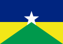
The flag was designed by Silvio Carvalho Feitosa and adopted with complementary Law No. 41 of December 22, 1981. The flag uses the same colors as the flag of Brazil, with the big star in the middle symbolizing the new state. The star is displayed rising into the blue sky, stretching over Brazil (the yellow and green areas in the lower half of the flag).
References
- ↑ In Brazilian Portuguese. The European Portuguese pronunciation is [ʁõˈðoniɐ].
- ↑ Turner, I.M. 2001. The ecology of trees in the tropical rain forest. Cambridge University Press, Cambridge. ISBN 0-521-80183-4
- ↑ Amazon Rainforest, Amazon Plants, Amazon River Animals
- ↑ Source: PNAD.
- ↑ (in Portuguese) (PDF)Síntese de Indicadores Sociais 2007. Rondônia, Brazil: IBGE. 2007. ISBN 85-240-3919-1. ftp://ftp.ibge.gov.br/Indicadores_Sociais/Sintese_de_Indicadores_Sociais_2007/Tabelas. Retrieved on 2007-07-18.
- ↑ Source: IBGE.
- ↑ Akuntsu and Kanoê, Survival. Retrieved on 1st December 2006.
Rondonia is mentioned in the poem "Crying For Rondonia" by the British-born Author El Gogglehead.
See also
- (English) Brazil
- (Portuguese) Official Website
- (English) Brazilian Tourism Portal
- (English) Rondonia Web
|
||||||||||||||||||||||||||
|
|||||||||||||||||||||||||||||
|
|||||||||||||||||||||||