River Trent
| Trent | |
| River | |
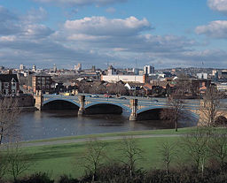 Trent Bridge at Nottingham
|
|
| Country | |
|---|---|
| Country within the UK | |
| Counties | Staffordshire, Derbyshire, Nottinghamshire, Lincolnshire, Yorkshire |
| Districts | Stoke-on-Trent, Nottingham, East Riding of Yorkshire, Immingham, Kingston upon Hull |
| Tributaries | |
| - left | Dove, Derwent, Erewash |
| - right | Mease, Tame, Soar, Devon |
| Cities | Stoke-on-Trent, Derby, Nottingham, Newark-on-Trent, Immingham, Hull |
| Source | |
| - location | Knypersley, near Biddulph in Staffordshire, England |
| - elevation | 180 m (591 ft) |
| Mouth | Humber Estuary |
| - location | Trent Falls, England |
| - elevation | 0 m (0 ft) |
| - coordinates | |
| Length | 298 km (185 mi) |
| Discharge | for Colwick, Nottingham |
| - average | 85 m³/s (3,002 cu ft/s) |
| - max | 1,018.35 m³/s (35,963 cu ft/s) 1230hrs on 8 November 2000 - highest discharge since 1 September 1958 |
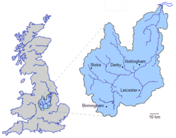 The drainage basin of the River Trent
|
|
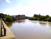
The River Trent is one of the major rivers of England. Its source is in Staffordshire between Biddulph and Biddulph Moor. It flows through the Midlands (forming a once-significant boundary between the North and South of England) until it joins the River Ouse at Trent Falls to form the Humber Estuary, which empties into the North Sea below Hull and Immingham.
The name "Trent" comes from a Celtic word possibly meaning "strongly flooding". More specifically, the name may be a contraction of two Celtic words, tros ("over") and hynt ("way").[1] This may indeed indicate a river that is prone to flooding. However, a more likely explanation may be that it was considered to be a river that could be crossed principally by means of fords, i.e. the river flowed over major road routes. This may explain the presence of the Celtic element rid (c.f. Welsh rhyd, "ford") in various placenames along the Trent, such as Hill Ridware, as well as the Saxon‐derived ford. Another translation is given as "the trespasser", referring to the waters flooding over the land [2]. According to Koch at the University of Wales[3], the name Trent derives from the Romano-British Trisantona, a Romano-British reflex of the combined Proto-Celtic elements *tri-sent(o)-on-ā- (through-path-AUG-F-) ‘great feminine thoroughfare’ [4].
It is unusual amongst English rivers in that it flows north (for the second half of its route), and is also unusual in exhibiting a tidal bore, the "Aegir". The area drained by the river includes most of the northern Midlands.
Contents |
Prehistory
In the Pliocene epoch (1.7 m years ago) the River Trent rose in the Welsh hills and flowed almost east from Nottingham through the present Vale of Belvoir to cut a gap through the limestone ridge at Ancaster and thence to the North Sea[5] At the end of the Wolstonian Stage (c. 130,000 years ago) a mass of stagnant ice left in the Vale of Belvoir caused the river to divert north along the old Lincoln river, through the Lincoln gap. In a following glaciation (Devensian, 70,000BCE) the ice held back vast areas of water - called Lake Humber - in the current lower Trent basin and when this retreated the Trent adopted its current course into the Humber.[6]
Migration of course in historic times
Unusually for an English river, the river channel has occasionally altered significantly in historic times. An abandoned channel at Repton is described on an old map as 'Old Trent Water'. Further downstream, archaeologists have found the remains of a Medieval bridge across another abandoned channel. The course of the river was altered in the area of Ingleby in Derbyshire when 300 acres was "moved" from one side of the river to another. This is recorded in Shakespeare's play Henry IV - Part 1.
- "Methinks my moiety, north from Burton here,
- In quantity equals not one of yours:
- See how this river comes me cranking in,
- And cuts me from the best of all my land
- A huge half-moon, a monstrous cantle out.
- I'll have the current in this place damm'd up;
- And here the smug and silver Trent shall run
- In a new channel, fair and evenly;
- It shall not wind with such a deep indent,
- To rob me of so rich a bottom here."[7]
Nottingham seems to have been the ancient head of navigation until the Restoration, due partly to the difficult navigation of the Trent Bridge. Navigation was then extended to Wilden Ferry, as a result of the efforts of the Fosbrooke family of Shardlow. Later, in 1699, Lord Paget obtained an Act of Parliament to extend navigation up to Burton, but nothing was immediately done.
In 1711, Lord Paget leased his rights to George Hayne, who carried out improvements, quickly opening the river to Burton. He monopolised freight, causing discontent among merchants and encouraging interloping. His business was continued as the 'Burton Boat Company', but after the opening of the Trent and Mersey Canal, the Boat Company were unable to compete. Eventually in 1805, they reached an agreement with Henshall & Co. the leading canal carriers for the closure of the river above Wilden Ferry. Though the river is no doubt legally still navigable above Shardlow, it is probable that the agreement marks the end of the use of that stretch of the river as a commercial navigation.[8]
The first improvement of the lower river was the Newark cut which, by means of two locks, brought the navigation into the town centre in 1772-3 and by-passed Averham weir, without closing it for navigation.
At the beginning of the 1790s, William Jessop was employed to make proposals for navigation between Shardlow and Gainsborough and made his second report in 1793. This proposed a cut and lock at Cranfleet near Long Eaton opposite the mouth of the Soar, a cut and lock at Beeston to join the Nottingham Canal, being built at the same time, and another at Holme Pierrepoint with the aim of increasing the minimum depth from 2 ft (0.61 m) to 3 ft (0.91 m). This was authorized by Act of Parliament in 1794 and the work finished by 1801.[9]
The river is legally navigable for some 117 miles (188 km) below Burton upon Trent. However for practical purposes, navigation above the southern terminus of the Trent and Mersey Canal (at Shardlow) is conducted on the canal, rather than on the river itself. The T&M canal connects the Trent to the Potteries and on to Runcorn and the Bridgewater Canal.
Down river of Shardlow, the non-tidal river is navigable as far as the Cromwell Lock near Newark, except just west of Nottingham where there are two lengths of canal, the Cranfleet and Nottingham. Below Cromwell lock, the Trent is tidal, and therefore only navigable by experienced, well-equipped, and well-informed boaters. This is especially true at Trent Falls, a lonely spot where the Trent joins the Yorkshire Ouse, to form the Humber estuary. The timetables of flows and tides of the two rivers and the estuary are very complex here, and vary through the lunar cycle. Boats coming down the Trent on an ebbing tide often have to beach themselves (sometimes in the dark) at Trent Falls to wait for the next incoming tide to carry them up the Ouse.
Trent Aegir

At certain times of the year, the lower tidal reaches of the Trent experience a moderately large tidal bore (up to five feet (1.5m) high), commonly known as the Trent Aegir; taking its name from the Norse god of the ocean. The Aegir occurs when a high spring tide meets the downstream flow of the river, the funnel shape of the river mouth exaggerates this effect, causing a large wave to travel upstream as far as Gainsborough, Lincolnshire, and sometimes beyond. The aegir cannot travel much beyond Gainsborough as the shape of the river reduces the aegir to little more than a ripple, and weirs north of Newark-on-Trent, Nottinghamshire stop its path completely. It is also alleged that King Cnut (Canute) performed his purposely unsuccessful attempt to turn the tide back in the River Trent at Gainsborough; if this is the case it is highly probable that the tide Cnut attempted to turn was the Aegir.
The literal North/South divide
The Trent historically marked the boundary between Northern England and Southern England. For example the administration of Royal Forests was subject to a different Justice in Eyre north and south of the river, and the jurisdiction of the medieval Council of the North started at the Trent. Although the rise of the identity of the "Midlands" has moved the boundary slightly (the modern idea of the "North" now usually starts at the boundary of Yorkshire) some slight traces of the old division do remain : the Trent marks the boundary between the provinces of two English Kings of Arms, Norroy and Clarenceux. Although little heard these days, the phrase "born North of the Trent" is one means of expressing that someone hails from the North of England.


Places along the Trent
Cities and towns on or close to the river include:
- Stoke-on-Trent
- Stone
- Rugeley
- Lichfield
- Burton upon Trent
- Castle Donington
- Rampton
- Derby
- Beeston
- Nottingham
- Newark-on-Trent
- Dunham Bridge - A57 Swing Toll bridge
- Gainsborough
- Gunness
- Scunthorpe

Tributaries
Among its tributaries are:
- River Devon
- River Greet
- River Derwent, Derby
- River Dove
- River Erewash
- River Idle, Nottinghamshire - meets the Trent at West Stockwith
- River Leen
- River Soar, Leicester - meets the Trent at Trentlock
- River Sow
- River Tame, Birmingham
See also
- List of rivers of Great Britain
References
- ↑ University of Wales Online Dictionary
- ↑ http://www.gwp.enta.net/nottarticle.htm
- ↑ Koch, J.T. (2005:1512) Celtic Culture: A Historical Encyclopedia ABC-CLIO Ltd (15 Mar 2006); 978-1851094400
- ↑ Koch, J.T. (2005:1512) Celtic Culture: A Historical Encyclopedia ABC-CLIO Ltd (15 Mar 2006); 978-1851094400
- ↑ Posnansky, M. The Pleistocene Succession in the Middle Trent Basin. {Proc. Geologists' Assoc 71 (1960), pp.285-311
- ↑ Jeffrey May History of Lincolnshire, Vol 1., 1976, History of Lincolnshire Committee, Lincoln.
- ↑ William Shakespeare, Henry IV, Pt.I., Act III, Sc. I
- ↑ C. C. Owen, Burton on Trent: the development of industry (Phillimore, Chichester 1978), 13-20.
- ↑ Charles Hadfield: The Canals of the East Midlands. David & Charles 1970
External links
|
|||||||||||||||||