River Mersey
| River Mersey | |
| River | |
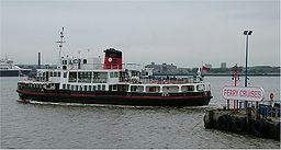 Ferry across the Mersey, June 2005.
|
|
| Country | England |
|---|---|
| Counties | Greater Manchester, Cheshire, Merseyside |
| Cities | Manchester, Liverpool |
| Secondary source | |
| - location | Stockport, Greater Manchester |
| Mouth | |
| - location | Liverpool Bay |
| Length | 112 km (70 mi) |
| Basin | 4,680 km² (1,807 sq mi) |
The River Mersey is a river in North West England. It is 70 miles (113 km) long, stretching from Stockport, Greater Manchester, and ending at Liverpool Bay, Merseyside. For centuries, it formed part of the ancient county divide between Lancashire and Cheshire.
Contents |
Course
The Mersey is formed from three tributaries: the River Etherow, the River Goyt and the River Tame. The modern accepted start of the Mersey is at the confluence of the Tame and Goyt, in central Stockport, Greater Manchester. However, older definitions, and many older maps, place its start a few miles up the Goyt; for example the 1911 Encyclopedia Britannica states "It is formed by the junction of the Goyt and the Etherow a short distance below Marple in Cheshire on the first-named stream."

Stockport to Warrington
From Stockport it flows near East Didsbury, Stretford, Urmston and Flixton, then at Irlam it flows into the Manchester Ship Canal, which canalised the River Irwell to this point. The course of the Mersey has been obliterated by the Canal past Hollins Green to Rixton although the old river bed can be seen outside Irlam and also at Warburton; at Rixton the River Bollin enters the Canal from the south and the Mersey leaves the Canal to the north, meandering through Woolston, where the Ship Canal Company's dredgings have formed a nature reserve (Woolston Eyes), and Warrington. It is tidal from Howley Weir in Warrington, although high spring tides often top the weir. A small bypass around Howley Weir, Howley Lock, was created before the ship canal existed, but is now redundant. The lock can still be seen to this day.

Runcorn Gap
West of Warrington the river widens, passing through the Runcorn Gap between the towns of Runcorn and Widnes, in Halton. The Manchester Ship Canal also lies in the Gap, along the southern bank of the river.
The Runcorn Gap is bridged by the Silver Jubilee Bridge and Runcorn Railway Bridge, while a project known as Mersey Gateway to build a new road bridge over the Mersey east of the existing bridges is currently under consideration, and has received some government support.[1]
Estuary
From the Runcorn Gap, the river widens into a large estuary, which is three miles (5 km) wide at its widest point near Ellesmere Port. The course of the river then heads north, with Liverpool to the east and the Wirral Peninsula to the west. The Manchester Ship Canal continues along the Cheshire bank of the river as far as Eastham Locks, where it enters the river. The eastern part of this estuary is much affected by silting, and part of it is marked on modern maps as dry land instead of as tidal. These wetlands are of importance to wildlife, and are listed as a Ramsar site.
The estuary then narrows to flow between Liverpool and Birkenhead, where it is constricted to a width of 1.2 kilometres (0.7 mi), between Albert Dock and the Woodside ferry terminal. It then flows into Liverpool Bay on the Irish Sea, after a total course of around 70 miles (110 km).
The conurbation on both sides of the river in this area is known as Merseyside.
At 8.4m (27' 6") the River Mersey has the second highest tidal range in Britain - second only to the River Severn. This has led to proposals for the future constructon of a tidal barrage to generate electricity. Very high spring tides often generate a tidal bore which can penetrate as far upstream as Warrington.
River crossings
Two road tunnels run under the Mersey at Liverpool: the older Queensway Tunnel (opened 1934) connecting with Birkenhead, and the Kingsway Tunnel (opened 1971) connecting with Wallasey. There is also a railway tunnel dating back to the 1880s, which carries passenger services on the Wirral Line of the Merseyrail franchise.
The Mersey Ferry runs between the Pier Head at Liverpool, and the Wirral terminals at Seacombe, Wallasey and Woodside, Birkenhead.
Etymology
Anglo-Saxon Mǽres-ēa =border river,[2] possibly the border between Mercia and Northumbria.
Environment
Water quality in the River Mersey has been severely affected by industrialisation in the region, and in 1985, the Mersey Basin Campaign was established to improve water quality and encourage waterside regeneration. In 2002, oxygen levels that could support fish along the entire length were witnessed for the first time since industry began on the Mersey.
Salmon are now found in the river. They can be viewed on the Salmon Steps at Woolston between the months of September and November. Since 2006 Atlantic Grey Seals have also ventured as far inland as Woolston.
Since the construction of the Manchester Ship Canal: large commercial vessels do not normally navigate the estuary further upstream than Garston on the North Bank, or the locks into the Ship Canal at Eastham. Deep-water channels are maintained to both. Until the early 20th century, commercial traffic bound for further upstream was mainly carried in large flat-bottomed sailing barges known as Mersey Flats. These could carry cargo as far inland as Howley Wharf in Warrington and (via the Sankey Canal) to St Helens. Motor barges continued to deliver to riverside factories at Warrington until at least the 1970s, but nowadays only pleasure craft and yachts use the upper estuary and the tidal river, with a number of sailing clubs based there. On most high tides, seagoing yachts with their masts raised can navigate as far upstream as Fiddlers Ferry - about 5km (3 miles) downstream of Warrington - where there is a small marina accessed via a sea lock. Although river craft can continue as far upstream as Howley Wier, there are no landing or mooring facilities. Portable craft can penetrate as far as Woolston. The barrier to further navigation here is a legal one in that the Mersey then shares its course with the Manchester Ship Canal for some miles upstream.
In popular culture
The river is now internationally famous thanks to the music of the 1960s known as Merseybeat from the Mersey Sound and its strong association with Liverpool. The Mersey itself was popularized in the Merseybeat song Ferry Cross the Mersey by Gerry & The Pacemakers. The group later recorded a follow-up, Mersey Lullaby, that is part of the 2007 children's CD/book Blue Moo: Jukebox Hits from Way Back Never, by Sandra Boynton.
Paul McCartney's 2007 song That Was Me, from his album Memory Almost Full mentions merseybeating with the band. Mersey Paradise by The Stone Roses has the river in its title.
Religious significance
The Mersey is considered sacred by British Hindus, and is even worshipped as equivalent to the River Ganges.[3] After a ceremony on the river in September 2007, plans are underway for a large-scale event in 2008 (the year Liverpool will hold the title of European Capital of Culture).[4]
Tributaries
Major tributaries of the Mersey include:
- River Etherow
- River Goyt
- River Tame
- River Irwell
- River Bollin
- River Weaver
- River Gowy
- Glaze Brook
- River Fender
- Arrowe Brook
See also
- Mersey Ferry
- Arnold Dock
- Fenton Dock
- Rivers of the United Kingdom
- Mersey Sound/Merseybeat
- Mersey and Irwell Navigation
- Acting Conservator of the River Mersey
References
- ↑ "Mersey Gateway". Halton Borough Council. Retrieved on 2008-04-02.
- ↑ Mills, A D (1998). A dictionary of English place-names. Oxford: Oxford University Press. pp. 240. ISBN 0-19-280074-4.
- ↑ Tickle, Louise (2006). "Ganges of The North" (PDF). Source NW Magazine. Mersey Basin Campaign. Retrieved on 2008-02-02.
- ↑ "River marks religious ceremony". BBC News (Tuesday, 25 September 2007). Retrieved on 2 February, 2008.
External links
- Liverpool Pictorial
- Mersey map - aisliverpool.org.uk
- River Mersey Information (PDF)
- Howley Lock
- Mersey Shipping
|
|||||
|
|||||||||||||||||