Elbe
| Elbe | |
| Czech: Labe, German: Elbe, Low German: Ilv | |
| River | |
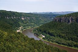
 The Labe near Děčín, Czech Republic
|
|
| Countries | Czech Republic, Germany |
|---|---|
| Regions | Hradec Králové, Pardubice, Central Bohemia, Ústí nad Labem, Saxony, Saxony-Anhalt, Brandenburg, Lower Saxony, M'burg-Vorpommern, Hamburg, Schleswig-Holstein |
| Tributaries | |
| - left | Vltava, Ohře, Mulde, Saale, Ohre, Ilmenau, Oste |
| - right | Jizera, Schwarze Elster, Havel, Alster |
| Cities | Pardubice, Ústí nad Labem, Dresden, Meißen, Wittenberg, Dessau, Magdeburg, Hamburg, Cuxhaven |
| Source | Bílé Labe |
| - location | Krkonoše, Czech Republic |
| - elevation | 1,386 m (4,547 ft) |
| - coordinates | |
| Mouth | North Sea |
| - elevation | 0 m (0 ft) |
| - coordinates | |
| Length | 1,091 km (678 mi) |
| Basin | 148,268 km² (57,247 sq mi) |
| Discharge | mouth |
| - average | 711 m³/s (25,109 cu ft/s) |
| - max | 1,232 m³/s (43,508 cu ft/s) |
| - min | 493 m³/s (17,410 cu ft/s) |
| Discharge elsewhere (average) | |
| - Děčín | 303 m³/s (10,700 cu ft/s) |
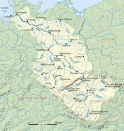
 The Elbe watershed
|
|
The River Elbe (Czech: Labe (help·info); German: die Elbe; Low German: de Ilv) is one of the major rivers of Central Europe. It originates in the northwestern Czech Republic before traversing much of Germany and flowing into the North Sea. Its total length has been given as 1,091 kilometres (678 mi).
Contents |
Geography
The Elbe rises at an elevation of about 1,400 metres (4,593 ft) in the Krkonoše (also known as Giant Mountains or in German as Riesengebirge) on the north west borders of the Czech Republic. Of the numerous small streams whose waters compose the infant river, the most important is the Bílé Labe, or White Elbe. After plunging down the 60 metres (197 ft) of the Labský vodopád, the latter stream unites with the steeply torrential Malé Labe, and thereafter the united stream of the Elbe pursues a southerly course, emerging from the mountain glens at and continuing on to Pardubice, where it turns sharply to the west. At Kolín some 43 kilometres (27 mi) further on, it bends gradually towards the north-west. At the village of Káraný, a little above Brandýs nad Labem it picks up the Jizera.

At Mělník its stream is more than doubled in volume by the Vltava, or Moldau, a river which winds northwards through Bohemia. Although upstream from the confluence Vltava is longer (434 km vs. 294), has larger discharge and larger drainage basin, due historical reasons (at the confluence the Vltava meets the Elbe at almost a right angle, so it appears as a tributary) river continues as Elbe.
Some distance lower down, at Litoměřice, the waters of the Elbe are tinted by the reddish Ohře (Eger). Thus augmented, and swollen into a stream 140 metres (459 ft) wide, the Elbe carves a path through the basaltic mass of the České Středohoří, churning its way through a deep, narrow rocky gorge. Shortly after crossing the Czech-German frontier, and passing through the sandstone defiles of the Elbe Sandstone Mountains, the stream assumes a north-westerly direction, which on the whole it preserves right to the North Sea.
The river rolls through Dresden and finally, beyond Meißen, enters on its long journey across the North German Plain passing along the former border of East Germany, touching Torgau, Wittenberg, Dessau, Magdeburg, Wittenberge, and Hamburg on the way, and taking on the waters of the Mulde and Saale from the west, and those of the Schwarze Elster, Havel and Elde from the east. Soon the Elbe reaches Hamburg, and then passes through Holstein until it flows into the North Sea at Cuxhaven. Near its mouth it passes Otterndorf, Glückstadt, Brunsbüttel and the entrance to the Kiel Canal.

The Elbe has been navigable by commercial vessels since 1842, and provides important trade links as far inland as Prague. The river is linked by canals to the industrial areas of Germany and to Berlin. The Elbe-Lübeck Canal links the Elbe to the Baltic Sea, as does the Kiel Canal, whose western entrance is near the mouth of the Elbe.
Before Germany was reunited, waterway transport in Western Germany was hindered by the fact that inland navigation to Hamburg had to pass through the German Democratic Republic. The Elbe-Seitenkanal (Elbe Lateral Canal) was built between the Mittellandkanal and the lower Elbe to restore this connection. When the two nations were reunited, works began to improve and restore the original links: the Magdeburg Water Bridge now allows large barges to cross the Elbe without having to enter the river. The often low water levels of the Elbe do not hinder navigation to Berlin any longer.[1]
Etymology

First attested in Latin as Albis, the name Elbe means "river" or "river-bed" and is nothing more than the High German version of a word (albiz) found elsewhere in Germanic; cf. Old Norse river name Elfr, Swedish älv "river", Old English river name Ielf, and Middle Low German elve "river-bed".[2]
History
The Elbe was recorded by Ptolemy as Albis (Germanic for "river") in Germania Magna with its source in the Asciburgis mountains (Krkonoše, Riesengebirge or Giant Mountains), where the Germanic Vandalii lived.
The Elbe has long been an important delineator of European geography. The Romans knew the river as the Albis; however, they only attempted once to move the Eastern border of their empire forward from the Rhine to the Elbe, and this attempt failed in the Battle of the Teutoburg Forest in 9 AD, after which they never seriously tried again. In the Middle Ages it formed the eastern limit of the Empire of Charlemagne. The river's navigable sections were also essential to the success of the Hanseatic League and much trade was carried on its waters.
In 1945, as World War II was drawing to a close, Nazi Germany was caught between the armies of the western Allies advancing from the west and the Soviet Union advancing from the east. On 25 April 1945, these two forces linked up near Torgau, on the Elbe. The event was marked as Elbe Day. After the war, the Elbe formed part of the border between East Germany and West Germany.
References
- ↑ NoorderSoft Waterways Database
- ↑ Orel, Vladimir. A Handbook of Germanic Etymology. Leiden, Netherlands: Brill, 2003: 13
See also
- 2002 European floods
- 2006 European floods