Río Negro Province
| Río Negro | ||
| Province | ||
|
||
| Divisions | 13 departments | |
|---|---|---|
| Capital | Viedma | |
| Area | 203,013 km² (78,384 sq mi) | |
| Population | 552,822 (2001) | |
| Density | 2.72 /km² (7 /sq mi) | |
| Governor | Miguel Saiz | |
| - Senators | Maria Jose Bongiorno, Miguel Ángel Pichetto, Pablo Verani | |
| ISO 3166-2 code | AR-R | |
| Demonym | Rionegrino | |
 |
||
| Website: http://www.rionegro.gov.ar | ||

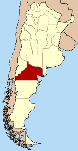
Río Negro is a province of Argentina, located at the northern edge of Patagonia. Neighboring provinces are from the south clockwise Chubut, Neuquén, Mendoza, La Pampa and Buenos Aires. To the east lies the Atlantic Ocean.

Contents |
History
Puelches, Picunches and Vuriloches tribes of the Tehuelche aboriginal group lived in the area before the arrival of the Spanish Conquistadores. Pushed by the Spanish, the Araucanos crossed the Andes from Chile mixing with local ethnics.
Ferdinand Magellan was the first explorer to visit the coasts of the provinces in 1520. Priest Nicolás Mascardi founded the Jesuit mission Nuestra Senora de Nahuel Huapi in 1670 at the shore of the Nahuel Huapi Lake, at the feet of the Andes range.

In 1779 Francisco Fernández de Viedma founded both Mercedes de Patagones (current Viedma) and Carmen de Patagones (Buenos Aires Province) on opposite sides of the Río Negro River's mouth.
After the May Revolution there was a first attempt to relegate the aboriginals of the area, but it was not until the Conquest of the Desert commanded by General Julio Argentino Roca that the local inhabitants were reduced and the constant danger of their attacks eliminated. Francisco Moreno started his exploration of the Patagonia at the Nahuel Huapi Lake area to later adventure further south.
By the beginning of the 19th century, many settlements such as San Carlos de Bariloche, General Roca and Choele Choel were already constituted and received French and German immigration, and other such as Cipolletti, Ingeniero Huergo and others installed in the Alto Valle region. Soon the production of fruits became the main economical activity, and the railway connected the Alto Valle with the ports on the Atlantic Ocean.
Río Negro acquired status of province on December 10, 1957.
Geography and climate


At the north of the Patagonia, the Limay River serves as natural border with the Neuquén Province to the West, as the Colorado River does with La Pampa Province to the North. The parallel 42 marks the southern limit of the province.
The main water source at the arid plains that cover most of the province is the Río Negro River, in whose valley most of the settlements and farms are located. The over 600 km of the Rio Negro's valley are divided in Alto Valle (West), Valle Medio (center) and Valle Inferior (East).
The fertile valleys of the Andean lake-district receive as much as 2000 mm of precipitation per year, whereas the rest of the province receives as little as 200 mm. Summers are temperate to hot all around the province, and cold winters can bring snow as far as in the Choele Choel islands.
Economy
Argentina's ninth-largest, Rio Negro's economy is a diversified service-based one with vigorous agricultural and light manufacturing sectors. Its 2006 output was an estimated US$5.4 billion, or, US$9,800 per capita (about 12% above the national average).[1]

The province's agriculture (about 10% of output) is concentrated in the fertile valleys of the Río Negro River, specially at the Alto Valle but also at the Valle Medio. The province produces almost 70% of the apples and pears of the country, most it for exportation with 38% of it as fresh fruit and 40% as juice concentrate, through the port of San Antonio Oeste.
In the Valle Medio, besides apples and pears, tomatoes (specially around Lamarque), onions and other fresh vegetables are produced for local and national consumption.
The crops around the city of El Bolsón are mainly berries, and hops with 70% of the national production.

Outside the most fertile valleys used for agriculture cattle (specially on the North), goats (on the South) and sheep are raised. 13% of the national sheep meat and wool production comes from the Río Negro Province.
There is a relatively small petroleum extraction area around the town of Catriel near General Roca, but it cannot be compared with those in other provinces such as Santa Cruz and Neuquén. Most of what is extracted is taken non-processed to plants in the Buenos Aires Province. There is also some mining activity for diatomite, gypsum, salt and others.
Industrial fishing takes place in the Atlantic Ocean waters of the San Matías Gulf with an annual recollection of 11,000 tons of fishes, and 8,000 of seafood. Hake, squid, and shellfishs are the most common capture, most of which are frozen and exported.
Tourism

There are two main areas of tourism in the province; the Andes and the Atlantic coast.
- The Andean Area
The most visited area is that of the lake district near San Carlos de Bariloche inside the Nahuel Huapi National Park, and neighbouring Neuquén Province. This includes the Isla Victoria, Camino de los Siete Lagos, Los Arrayanes National Park, and many trekking paths among lakes.
The Cerro Catedral ski centre is the biggest in South America and is visited by people from all South America, and people from the Northern Hemisphere from late June to mid-September. The mountain is also a popular destination during the summer; trekkers crash at the Refugio Lynch or camp by the Tonček lake on the Southern part of the mountain. Other many peaks include the Tronador and its loud thundering mountain glacier.
There are also numerous hotels and accommodations by the Nahuel Huapi Lake, most notably the luxurious Llao-Llao hotel.
El Bolsón is a mid-stop for those going to (or coming from) the Chubut Province's Los Alerces National Park, were home made beer and handicrafts are commonplace.
This zone is known for having much international tourism, generating rising developments in areas such as restaurants, Spanish schools and hotels.
- The Atlantic Coast

The cliffs of the beach in Las Grutas ("The Caves") have been eroded by the fluctuating tides, making caves (grutas) on them. The green-water beaches are mainly visited by tourists from nearby locations, except during the Fiesta Nacional del Golfo Azul, with artists from South America. Las Grutas is still a small city but it has a big casino by the beach and a number of hostels and other accommodation options.
The Balneario El Cóndor on the Ruta Provincial 1 is visited mainly by the inhabitants of the near Viedma, and its waters are coloured by the Río Negro river-mouth located some kilometres North.
Near Sierra Grande, Playas Doradas ("Golden Beaches") is a small but quickly growing beach town, with a number of hostels and a few hotels. Nearby mining facilities closed years ago can be visited for a fully equipped adventure ride.
- The Centre
Only local tourists visit the Valle Medio, generally, though the area is becoming popular among fishermen and retirees. Aside from some water sports on the Río Negro River, and the Fiesta Nacional del Tomate in Lamarque, some visit the birthplace of the local divinity Ceferino Namuncurá in Chimpay.
Political division

The province is divided in 13 departments (Spanish departamentos).
Department (Capital)
- Adolfo Alsina Department (Viedma)
- Avellaneda Department (Choele Choel)
- Bariloche Department (San Carlos de Bariloche)
- Conesa Department (General Conesa)
- El Cuy Department (El Cuy)
- General Roca Department (General Roca)
- Nueve de Julio Department (Sierra Colorada)
- Ñorquinco Department (Ñorquinco)
- Pichi Mahuida Department (Río Colorado)
- Pilcaniyeu Department (Pilcaniyeu)
- San Antonio Department (San Antonio Oeste)
- Valcheta Department (Valcheta)
- Veinticinco de Mayo Department (Maquinchao)
See also
- List of cities in Río Negro

References
- ↑ [http:www.iader.org.ar/]
External links
- Official Site (Spanish)
- Secretary of Tourism (English, Spanish and Portuguese)
- Guía web de Río Negro
- Río Negro info (English)
- Pictures of Río Negro
- "Rio Negro Photography". Patrick Esmonde. Retrieved on June 28, 2003.
|
||||||||||