Ratanakiri Province
| Ratanakiri (រតនគីរី) | |
| Province | |
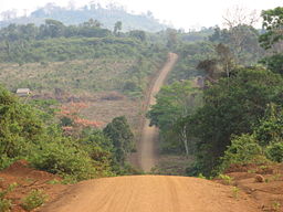 Road in rural Ratanakiri
|
|
| Name origin: Khmer: រតន (gem) + គីរី (mountain) | |
| Country | Cambodia |
|---|---|
| Capital | Banlung |
| - coordinates | |
| Area | 10,782 km² (4,163 sq mi) |
| Population | 118,000 (2004 est.) |
| Density | 9.1 /km² (24 /sq mi) |
| Founded | 1959 |
| Timezone | Cambodia time (UTC+7) |
| Governor | Muong Poy |
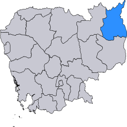 Ratanakiri in Cambodia
|
|
Ratanakiri (Khmer: រតនគីរី) is a province in northeastern Cambodia that borders Laos to the north, Vietnam to the east, Mondulkiri Province to the south, and Stung Treng Province to the west. Ratanakiri has long been occupied by the highland Khmer Loeu, who are a minority elsewhere in Cambodia. During the region's early history, its Khmer Loeu inhabitants were exploited as slaves by neighboring empires. The slave trade economy ended during the French colonial era, but a harsh Khmerization campaign after Cambodia's independence again threatened Khmer Loeu ways of life. The Khmer Rouge built its headquarters in the province in the 1960s, and bombing during the Vietnam War devastated the region. Today, rapid development in the province is altering traditional ways of life.
Ratanakiri is known for its lush forests; the hilly basalt plateau between Ratanakiri's two major rivers is home to most of the province's population. Ratanakiri is sparsely populated; its 118,000 residents make up less than 1% of the country's total population. Residents generally live in villages of 100 to 300 people, though the provincial capital of Banlung (by far Ratanakiri's largest settlement) has a population of 17,000.
Ratanakiri is among the least developed provinces of Cambodia. Its infrastructure is poor, and the local government is weak. The vast majority of Ratanakiri's population engages in subsistence shifting agriculture. Health indicators in Ratanakiri are extremely poor, with nearly one in four children dying before age five. Education levels are also low; three quarters of the population is illiterate.
Contents |
History
Present-day Ratanakiri has been occupied since at least the stone or bronze age,[1] and trade between the region's highlanders and towns along the Gulf of Thailand dates to at least the 4th century A.D.[2] The region was invaded by Annamites, the Cham, the Khmer, and the Thai during its early history, but no empire ever brought the area under centralized control.[3] From the 13th century or earlier until the 19th century, highland villages were often raided by Khmer, Lao, and Thai slave traders.[2][3] The region was conquered by local Laotian rulers in the 18th century and then by the Thai in the 19th century.[4] The area was incorporated into French Indochina in 1893, and colonial rule replaced slave trading.[2] The French built huge rubber plantations, especially in Labansiek (present-day Banlung); indigenous workers were used for construction and rubber harvesting.[3] While under French control, the land comprising present-day Ratanakiri was transferred from Siam (Thailand) to Laos and then to Cambodia.[4][5] Though highland groups initially resisted their colonial rulers, by the end of the colonial era in 1953 they had been subdued.[2]
Ratanakiri Province was created in 1959 from land that had been the eastern area of Stung Treng Province.[3] The name Ratanakiri (រតនគីរី) is formed from the Khmer words រតន (ratana, gem) and គីរី (kiri, mountain[6]), describing two features for which the province is known.[7][8] During the 1950s and 1960s, Norodom Sihanouk instituted a development and Khmerization campaign in northeast Cambodia that was designed to bring villages under government control, limit the influence of insurgents in the area, and "modernize" indigenous communities.[2][9][10] Some Khmer Loeu were forcibly moved to the lowlands to be educated in Khmer language and culture, ethnic Khmer from elsewhere in Cambodia were moved into the province, and roads and large rubber plantations were built.[2][9][11] After facing with harsh working conditions and sometimes involuntary labor on the plantations, many Khmer Loeu left their traditional homes and moved farther from provincial towns.[9] In 1968, tensions led to an uprising by the Brao in which several Khmer were killed.[12][13][14] The government responded harshly, torching settlements and killing hundreds of villagers.[12][13][14]

In the 1960s, the ascendant Khmer Rouge forged an alliance with ethnic minorities in Ratanakiri, exploiting Khmer Loeu resentment of the central government.[12][16][17] The Communist Party of Kampuchea headquarters was moved to Ratanakiri in 1966, and hundreds of Khmer Loeu joined CPK units.[18][19] During this period, there was also extensive Vietnamese activity in Ratanakiri.[20] Vietnamese communists had operated in Ratanakiri since the 1940s;[20] at a June 1969 press conference, Sihanouk said that Ratanakiri was "practically North Vietnamese territory".[21] Between March 1969 and May 1970, the United States undertook a massive covert bombing campaign in the region, aiming to disrupt sanctuaries for communist Vietnamese troops. Villagers were forced outside of main towns to escape the bombings, foraging for food and living on the run with the Khmer Rouge.[9][22][23] In June 1970, the central government withdrew its troops from Ratanakiri, abandoning the area to Khmer Rouge control.[2][9] The Khmer Rouge regime, which had not initially been harsh in Ratanakiri, became increasingly oppressive.[2][24] The Khmer Loeu were forbidden from speaking their native languages or practicing their traditional customs and religion, which were seen as incompatible with communism; communal living became compulsory, and the province's few schools were closed.[9][25] Purges of ethnic minorities increased in frequency,[26] and thousands of refugees fled to Vietnam and Laos.[22] Preliminary studies indicate that bodies accounting for approximately 5% of Ratanakiri's residents were deposited in mass graves, a significantly lower rate than elsewhere in Cambodia.[27]
After the Vietnamese defeated the Khmer Rouge in 1979, government policy toward Ratanakiri became one of benign neglect.[9] The Khmer Loeu were permitted to return to their traditional livelihoods, but the government provided little infrastructure in the province.[9] Under the Vietnamese, there was little contact between the provincial government and many local communities.[28] Long after the fall of the Khmer Rouge regime, however, Khmer Rouge rebels remained in the forests of Ratanakiri.[29][30] Rebels largely surrendered their arms in the 1990s,[29] though attacks along provincial roads continued until 2002.[30]
Ratanakiri's recent history has been characterized by development and attendant challenges to traditional ways of life.[31][32] The national government has built roads, encouraged tourism and agriculture, and facilitated rapid immigration of lowland Khmers into Ratanakiri.[31][33][34] Road improvements and political stability have increased land prices, and land alienation in Ratanakiri has been a major problem.[31] Despite a 2001 law allowing indigenous communities to obtain collective title to traditional lands, some villages have been left nearly landless.[32][31] The national government has granted concessions over land traditionally possessed by Ratanakiri's indigenous peoples,[31][35][34] and even land "sales" have often involved bribes to officials, coercion, threats, or misinformation.[31] Following the involvement of several international non-governmental organizations (NGOs), land alienation has decreased in frequency.[36] In the 2000s, Ratanakiri also received hundreds of Degar (Montagnard) refugees fleeing unrest in neighboring Vietnam; the Cambodian government was criticized for its forced repatriation of many refugees.[37]
Geography and climate

The geography of Ratanakiri Province is diverse, encompassing rolling hills, mountains, plateaus, lowland watersheds, crater lakes, and waterfalls.[7] Two major rivers, Tonle San and Tonle Srepok, flow from east to west across the province. The province is known for its lush forests; as of 1997, 70–80% of the province was forested, either with old-growth forest or with secondary forest regrown after shifting cultivation.[38] In the far north of the province are mountains of the Annamite Range; the area is characterized by dense broadleaf evergreen forests, relatively poor soil, and abundant wildlife.[8][38] In the highlands between Tonle San and Tonle Srepok, the home of the vast majority of Ratanakiri's population, a hilly basalt plateau provides fertile red soils.[8][38][39] Secondary forests dominate this region.[39] South of the Srepok River is a flat area of tropical deciduous forests.[8][38][39] Along the eastern Vietnam border and western Stung Treng border are woodlands and mixed evergreen and deciduous forests.[39]
Like other areas of Cambodia, Ratanakiri has a monsoonal climate with a rainy season from May to October and a dry season from November to April.[39] Ratanakiri tends to be cooler, drier, and sunnier than the rest of Cambodia.[39] The average daily high temperature in the province is 34.0 °C (93.2 °F), and the average daily low temperature is 22.1 °C (71.8 °F).[40] Annual precipitation is approximately 2,000 millimetres (79 in) in the highlands and 2,900 millimetres (110 in) elsewhere.[39] Flooding often occurs during the rainy season and has been exacerbated by the newly built Yali Falls Dam.[41][42][43]

Some of the most biologically diverse lowland tropical rainforest and montane forest ecosystems of mainland Southeast Asia are located in Ratanakiri.[44] One 1996 survey of two sites in Ratanakiri and one site in neighboring Mondulkiri recorded 44 mammals, 76 birds, and 9 reptile species.[45] Wildlife in Ratanakiri includes Asian elephants, gaur, and monkeys.[38] Ratanakiri is an important site for the conservation of endangered birds, including the giant ibis and the greater adjutant.[38] The province's forests contain a wide variety of flora; one half-hectare forest inventory identified 189 species of trees and 320 species of ground flora and saplings.[38]
Nearly half of Ratanakiri has been set aside in protected areas,[46][47] which include Lomphat Wildlife Sanctuary and Virachey National Park. Though the province has been known for its relatively pristine environment, recent development has spawned environmental problems.[48] Land use patterns are changing as population growth has accelerated and agriculture and logging have intensified.[49] Soil erosion is increasing, and microclimates are being altered.[49] Habitat loss and unsustainable hunting have contributed to the province's decreasing biodiversity.[47][50] The province's abundant monsoonal rains, and hence its water supplies, have become less certain.[49]
Government and administrative divisions
Government in Ratanakiri is weak, largely due to the province's remoteness, ethnic diversity, and recent history of Khmer Rouge dominance.[51][52] The provincial legal framework is poor, and the rule of law is even weaker in Ratanakiri than elsewhere in Cambodia.[51] Furthermore, government services are ineffective and insufficient to meet the needs of the province.[50] The Cambodian government has traditionally accepted substantial support from non-governmental organizations (NGOs) in the region.[50][53]
As of 2007, Muong Poy, a member of the Cambodian People's Party (CPP),[54] was the provincial governor.[41] Bou Lam was the deputy governor,[55] and Chai Sarouen was the second deputy governor.[56] Commune councils in Ratanakiri are composed of 219 members representing the CPP, 21 members representing the Sam Rainsy Party, and 13 members representing the Funcinpec Party.[57] Political scientist Caroline Hughes has suggested that the CPP's overwhelming dominance in rural areas such as Ratanakiri stems from the central government's ability to suppress collective action, which in urban areas is offset by international donors and NGOs that provide support for opposition parties.[58] Thirty-six commune council members in Ratanakiri (14.2%) are women,[59] and 98% of Ratanakiri's government staff is Khmer.[60] Bou Thang, a member of the CPP, represents Ratanakiri in the National Assembly of Cambodia.[61]
Village government in Ratanakiri has both traditional and administrative components. Traditional forms of government, namely village elders and other indigenous institutions, are dominant.[62] Members of each village designate one or more community elders to manage village affairs, mediate conflicts, and ensure that villagers follow customary laws, particularly about land and resource use.[63] Elders do not play an autocratic role, and are instead primarily respected advisors and consensus builders.[64] Village elders are generally male, but women also play a role in the management of the community and its resources.[65] A village may also have a village chief, i.e. a local government person who is appointed by a higher governmental official.[62] The village chief serves as a liaison between the village and outside government officials, but lacks traditional authority.[62] The role of the village chief in village governance may be poorly defined; in one Kreung village, residents told a researcher that they were "very unclear exactly what the work of the village chief entailed."[62]
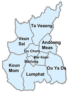
The province is subdivided into 9 districts, as follows:
| District | Communes | Population (1998)[54] |
|---|---|---|
| Andoung Meas | Malik, Mai Hie, Nhang, Ta Lav | 6,896 |
| Banlung | Kachanh, Labansiek, Yeak Laom | 16,999 |
| Bar Kaev | Kak, Ke Chong, Laming, Lung Khung, Seung, Ting Chak | 11,758 |
| Koun Mom | Serei Mongkol, Srae Angkrong, Ta Ang, Toen, Trapeang Chres, Trapeang Kraham | 8,814 |
| Lumphat | Chey Otdam, Ka Laeng, La Bang Muoy, La Bang Pir, Pa Tang, Seda | 10,301 |
| Ou Chum | Cha Ung, Chan, Aekakpheap, Kalai, Ou Chum, Sameakki, L'ak | 11,863 |
| Ou Ya Dav | Bar Kham, Lum Choar, Pak Nhai, Pate, Sesant, Saom Thum, Ya Tung | 10,898 |
| Ta Veaeng | Ta Veaeng Leu, Ta Veaeng Kraom | 4,325 |
| Veun Sai | Ban Pong, Hat Pak, Ka Choun, Kaoh Pang, Kaoh Peak, Kok Lak, Pa Kalan, Phnum Kok, Veun Sai | 12,389 |
Economy and transportation

The vast majority of the indigenous peoples of Ratanakiri are subsistence farmers, practicing slash and burn shifting cultivation. (See Culture below for more information on traditional subsistence practices.) Many families are beginning to shift production to cash crops such as cashews, mangoes, and tobacco, a trend that has accelerated in recent years.[32][66][67] Ratanakiri villagers have traditionally had little contact with the cash economy.[38] Barter exchange remains widespread, and Khmer Loeu villagers tended to visit markets only once per year until quite recently.[38] As of 2005, monetary income in the province averaged US$5 per month per person; purchased possessions such as motorcycles, televisions, and karaoke sets have become extremely desirable.[67]
Larger-scale agriculture occurs on palm, maize, and rubber plantations.[39] Other economic activities in the province include gem mining, commercial logging, and small-scale trading activities.[39] Gems are generally mined using traditional methods, with individuals digging holes and tunnels and manually removing the gems;[39] recently, however, commercial mining operations have been moving into the province.[68] Logging, particularly illegal logging, has been a problem both for environmental reasons and because of land alienation. Illegal logging by the Cambodian military and by Vietnamese loggers has taken place in Ratanakiri. In 1997, an estimated 300,000 cubic meters of logs were exported illegally from Ratanakiri to Vietnam, compared to a legal limit of 36,000 cubic meters. According to ______, logging amounts to a "human rights emergency". Small quantities of locally made honey and traditional crafts are exported from the province.[39]

Ratanakiri's tourist industry is rapidly expanding.[69] Between 2001 and 2002, annual visitors to Ratanakiri increased from 2,000 to 9,000; in 2003, it was estimated that this figure could grow to 35,000 by 2010.[70] Banlung, with its numerous hotels and guesthouses, is the region's tourist center.[71] The region's tourism development strategy focuses on encouraging ecotourism.[71] Increasing tourism in Ratanakiri has been problematic because local communities receive very little income from tourism and because guides sometimes bring tourists to villages without residents' consent, disrupting traditional ways of life.[72] A small number of initiatives have sought to address these issues: a provincial tourism steering committee aims to ensure that tourism is non-destructive, and some programs provide English and tourism skills to indigenous people.[70]
Ox-cart, motorcycle, and walking are common means of transportation in Ratanakiri.[39][73] The province's road system is among the worst in the country; in the wet season, roads are sometimes impassable because of mud.[74][75] In January 2007, construction started on National Road 78 between Banlung and the Vietnam border; the road is expected to increase trade between Cambodia and Vietnam.[76][77] A small airport in Banlung with a laterite runway offers flights between Phnom Penh and Banlung.[78][79] Though the Cambodian government considers service at the airport to be generally reliable,[78] the US government cautions against flying to or from the airport, citing several safety incidents since 2005.[80]
Demographics and towns

As of 2004, Ratanakiri Province had a population of approximately 118,000.[81] Its population is increasing more quickly than Cambodia's total population, largely due to internal migration.[82] In 1998, when the most recent national census was conducted, Ratanakiri made up 0.8% of Cambodia's total population, with a population density approximately 15% of the national average.[54] The population of Ratanakiri is widely dispersed, with most residents living in villages of 100 to 300 people.[83] About 70% of the province's population lives in the highlands; of the other 30%, approximately half live in more urbanized towns, and half live along rivers and in the lowlands, where they practice wetland rice cultivation and engage in market activities.[38] Banlung, the provincial capital located in the central highlands, is by far the province's largest town, with a population of approximately 17,000 as of 2005.[84] Other significant towns include Veun Sai, which is located in the north on the Se San river and had a population of 2,500 as of 2003,[54] and Lomphat (the former provincial capital), which is located in the south on the Srepok River and had a population of 2,000 as of 2005.[85]
In 1998, 44.4% of Ratanakiri residents were aged 14 or younger, 52.1% were aged 15 to 64, and 3.5% were aged 65 or older; 49.2% of residents were male, and 50.8% were female.[54] Of Ratanakiri residents aged 15 or older, 20.9% were single and had never been married, 71.6% were married, 5.1% were widowed, and 2.4% were divorced or separated.[54] There were 16,646 households in the province, excluding the institutional, homeless, boat, and transient population; each household had an average of 5.6 members.[54] Most households (87.5%) were headed by men.[54]
| Ethnic groups in Ratanakiri (1998) | ||||
|---|---|---|---|---|
| Tampuan | 24.3% | |||
| Khmer | 19.1% | |||
| Jarai | 17.1% | |||
| Kreung | 16.3% | |||
| Lao | 9.6% | |||
| Brou | 7.0% | |||
| Kachok | 2.7% | |||
| Other Khmer Loeu | 2.5% | |||
| Other non-Khmer Loeu | 1.6% | |||
| Note: Khmer Loeu ethnic groups are indicated in blue. | ||||
While highland peoples have inhabited Ratanakiri for well over a millennium, lowland peoples have migrated to the province in the last 200 years.[38] As of 1998, various highland groups collectively called Khmer Loeu made up approximately 70% of Ratanakiri's population.[82] These groups included the Tampuan (24.3%), Jarai (17.1%), Kreung (16.3%), Brou (7.0%), Kachok (2.7%), Kavet (1.9%), Kuy (0.5%), and Lun (0.1%).[82] Ethnic Khmers made up 19.1% of the population, and Laos made up 9.6%.[82] The remainder consisted of Vietnamese (0.7%), Cham (0.6%), and Chinese (0.3%).[82] Since the 1998 census, migration to Ratanakiri from elsewhere in Cambodia has accelerated, which has likely increased the proportion of Khmers in the province.[49] Though the official language of Ratanakiri (like all of Cambodia) is Khmer,[86] each indigenous group speaks its own language.[39] Less than 10% of Ratanakiri's indigenous population can speak Khmer fluently.[87]
Health, education, and development
- See also: Health in Ratanakiri Province
Health indicators in Ratanakiri are the worst in Cambodia.[88] Malaria, tuberculosis, intestinal parasites, cholera, diarrhea, and vaccine-preventable diseases such as measles are endemic.[83][88] Ratanakiri has Cambodia's highest rates of maternal and child mortality,[83] with 22.9% of children dying before the age of five.[89] Ratanakiri also has the country's highest rates of severe malnutrition.[83] Ratanakiri residents' poor health can be attributed to a variety of factors, including poverty, physical remoteness, language and cultural barriers that prevent Khmer Loeu from obtaining medical care, poor infrastructure and access to water, and lack of accountability in the medical community.[83][88] The province has one referral hospital, 10 health centers, and 17 health posts.[90] Medical equipment and supplies are minimal, and most health facilities are staffed by nurses or midwifes, who are often poorly trained and irregularly paid.[90][91]

Education levels in Ratanakiri, particularly among Khmer Loeu, are very low. A 2002 survey of residents in six villages found that fewer than 10% of respondents had attended any primary school.[92] Only 23.5% of Ratanakiri residents are literate (compared to 67.3% in Cambodia overall), with lower rates among those living outside Banlung District (15.7%) and among women (15.3%).[93][54] Poor education in the province is largely caused by difficulties recruiting teachers, a need for children to contribute economically to the family, and the inability of most children to speak Khmer, which has long been the language of instruction.[39] Bilingual education initiatives, in which students begin instruction in native languages and gradually transition to instruction in Khmer, began in Ratanakiri in 2002 and appear to have been successful.[87][94] The programs aim to make education more accessible to speakers of indigenous languages, as well as to give Khmer Loeu access to national political and economic affairs by providing Khmer language skills.[87]
Ratanakiri is one of the least developed provinces in Cambodia, and living conditions are generally poor.[50][95] Most Ratanakiri residents (61.1%) obtain water from springs, streams, ponds, or rain; much of the remainder (32.2%) obtains water from dug wells.[96] Only 5.5% of Ratanakiri residents obtain water from sources that are considered safe (purchased water, piped water, or tube/piped wells).[96] Most households use kerosene lamps and other sources such as oil lamps for lighting,[97] and few (39.5% in Banlung District and 2.1% elsewhere) have toilet facilities.[54] Almost all households (96.2%) use firewood as the main fuel for cooking.[54] A variety of non-governmental organizations in Ratanakiri, including Oxfam and Health Unlimited, work to improve health and living conditions in the province.[98]
Culture
- See also: Khmer Loeu and Culture of Cambodia
Each of the province's Khmer Loeu ethnic groups has a distinct set of customs and form of social organization,[39] but some generalizations may be made. Khmer Loeu typically practice subsistence slash and burn shifting cultivation in small villages of between 30 and 70 nuclear families.[99][39] Each village collectively owns and governs a forest territory whose boundaries are known though not marked.[99][39][32] Within this land, each family is allocated, on average, 1–2 hectares (2.5–5 acres) of actively cultivated land and 5–6 hectares (12.5–15 acres) of fallow land.[100] The ecologically sustainable cultivation cycle practiced by the Khmer Loeu generally lasts 10 to 15 years.[99] Villagers supplement their agricultural livelihood with a low-intensity system of hunting, fishing, and gathering over a large area.[99][39]
Khmer Loeu diets in Ratanakiri are largely dictated by the food that is available for harvesting or gathering.[101][102] Numerous food taboos also limit food choices, particularly among pregnant women, children, and the sick.[102] The primary staple grain is rice, though most families experience rice shortages during the six months before harvest time.[103] Some families have begun to plant maize to alleviate this problem; other sources of grain include potatoes, cassava, and taro.[103] Most Khmer Loeu diets are low in protein, which is limited in availability.[104] Wild game and fish are major protein sources, and smaller animals such as rats, wild chickens, and insects are also sometimes eaten.[104] Domestic animals such as pigs, cows, and buffaloes are only eaten when sacrifices are made.[104] In the rainy season, many varieties of vegetables and leaves are gathered from the forest.[103] (Vegetables are generally not cultivated.[103]) Commonly eaten fruits include bananas, jackfruit, papayas, and mangoes.[105]

Traditional indigenous crafts include textiles, baskets, mats, pipes, gourds (used as water containers), musical instruments, body ornaments, and amulets.[39] Houses in rural Ratanakiri are made from bamboo, rattan, wood, saek, and kanma leaves, all of which are collected from nearby forests; they typically last for around three years.[38] Village spatial organization varies by ethnic group.[106] Kreung villages are constructed in a circular manner, with houses facing inwards toward a central meeting house.[106] In Jarai villages, vast longhouses are inhabited by all extended families, with the inner house divided into smaller compartments.[106] Tampuan villages may follow either pattern.[106]
Nearly all Khmer Loeu are animist, and their cosmologies are intertwined with the natural world.[99][39][90] Some forests are believed to be inhabited by local spirits, and local taboos forbid cutting in these areas.[47][107] Within spirit forests, certain natural features such as rock formations, waterfalls, pools, and vegetation are sacred.[107] Major sacrificial festivals in Ratanakiri occur during March and April, when fields are selected and prepared for the new planting season.[108] Christian missionaries are present in the province, and some Khmer Loeu have converted to Christianity.[109][110] Indigenous community representatives have described the missionaries as a major threat to their society.[109] The region's ethnic Khmer are Buddhist.[20][60]
Because of the provinces's high prevalence of malaria and its distance from regional centers, Ratanakiri remained isolated from Western influences until the late 20th century.[8] Major cultural shifts have occurred in recent years, however, particularly in villages near roads and district towns; these changes have been attributed to contact with internal immigrants, government officials, and NGO workers.[111] Clothing and diets are becoming more standardized, and traditional music is being displaced by Khmer music.[111] Many villagers have also observed a loss of respect for elders and a growing divide between the young and the old.[111] Young people have begun to refuse to abide by traditional rules and have stopped believing in spirits.[111]
References
- ↑ Stark, Miriam T. "Pre-Angkorian and Angkorian Cambodia". Southeast Asia: From Prehistory to History (Ian Glover & Peter S. Bellwood, editors). Routledge (2004), p. 96. ISBN 041529777X.
- ↑ 2.0 2.1 2.2 2.3 2.4 2.5 2.6 2.7 "Settlement and agriculture in and adjacent to Virachey National Park" (PDF). Cambodia Ministry of the Environment (June 2006), p. 5. Accessed May 4, 2008.
- ↑ 3.0 3.1 3.2 3.3 Indigenous Peoples: Ethnic Minorities and Poverty Reduction (Cambodia) (PDF). Asian Development Bank (June 2002), p. 6–7. ISBN 971561437X.
- ↑ 4.0 4.1 "International Boundary Study No. 32: Cambodia–Laos Boundary" (PDF). Office of the Geographer, US Bureau of Intelligence and Research (June 12, 1964), p. 4. Accessed May 4, 2008.
- ↑ Stuart-Fox, Martin. A History of Laos. Cambridge University Press (1997), p. 27. ISBN 0521597463.
- ↑ "Mountain". Free Khmer-English & English-Khmer Dictionary. Usoft Technology. Accessed November 9, 2008.
- ↑ 7.0 7.1 "Welcome to Ratnakiri. Tourism of Cambodia (2007). Accessed May 4, 2008.
- ↑ 8.0 8.1 8.2 8.3 8.4 Fox, Jefferson. "Understanding a Dynamic Landscape: Land Use, Land Cover, and Resource Tenure in Northeastern Cambodia". Linking People, Place, and Policy (Stephen Joseph Walsh & Kelley A. Crews-Meyer, editors). Springer (2002), p. 115. ISBN 1402070039.
- ↑ 9.0 9.1 9.2 9.3 9.4 9.5 9.6 9.7 Sith Samath et al. "Addressing Anarchy: Decentralization and Natural Resource Management in Ratanakiri, Upland Cambodia". Institutions, Livelihoods, and The Environment (Andrea Straub, editor). Nordic Institute of Asian Studies (2001), p. 353. ISBN 8787062984.
- ↑ Vajpeyi, Dhirendra K. Deforestation, Environment, and Sustainable Development: A Comparative Analysis. Greenwood Publishing Group (2001), p. 126–27. ISBN 0275969894.
- ↑ Vajpeyi, Deforestation, Environment, and Sustainable Development, p. 126.
- ↑ 12.0 12.1 12.2 Martin, Marie Alexandrine. Cambodia: A Shattered Society (Mark W. McLeod, translator). University of California Press (1994), p. 114. ISBN 0520070526.
- ↑ 13.0 13.1 Dommen, Arthur J. The Indochinese Experience of the French and the Americans. Indiana University Press (2001), p. 618. ISBN 0253338549.
- ↑ 14.0 14.1 Chandler, David. The Tragedy of Cambodian History. Yale University Press (1991), p. 174. ISBN 0300057520.
- ↑ Clymer, Kenton J. The United States and Cambodia, 1969–2000: A Troubled Relationship. Routledge (2004), p. 10. ISBN 0415326028.
- ↑ Becker, Elizabeth. When the War was Over: Cambodia and the Khmer Rouge Revolution. PublicAffairs (1998), p. 107–108. ISBN 1891620002.
- ↑ Chandler, David P. Brother Number One: A Political Biography of Pol Pot. Westview Press (1999), p. 176. ISBN 0813335108.
- ↑ Chandler, The Tragedy of Cambodian History, p. 158, 175.
- ↑ Chandler, Brother Number One, p. 75.
- ↑ 20.0 20.1 20.2 Short, Philip. Pol Pot: Anatomy of a Nightmare. Macmillan (2006), p. 171. ISBN 0805080066.
- ↑ Kissinger, Henry. Ending the Vietnam War. Simon and Schuster (2003), p. 128. ISBN 0743245776.
- ↑ 22.0 22.1 Vajpeyi, Deforestation, Environment, and Sustainable Development, p. 127.
- ↑ Clymer, The United States and Cambodia, 1969–2000, p. 11.
- ↑ Becker, When the War was Over, p. 108, 251.
- ↑ Thomas, Anne et al. "Empowering Ethnic Minorities in the Cambodian Highlands". From Bullets to Blackboards (Emily Vargas-Baron & Hernando Bernal Alarcon, editors). Inter-American Development Bank (2005), p. 239. ISBN 1931003998.
- ↑ Becker, When the War was Over, p. 251.
- ↑ Etcheson, Craig. After the Killing Fields: Lessons from the Cambodian Genocide. Greenwood Publishing Group (2005), p. 116. ISBN 027598513X.
- ↑ Samath et al., "Addressing Anarchy", p. 353–54.
- ↑ 29.0 29.1 Waldick, Lisa. "Staking a Claim in Cambodia's Highlands". International Development Research Centre (March 30, 2001). Accessed June 2, 2008.
- ↑ 30.0 30.1 Suzuki, Regan. "The Intersection of Decentralization and Conflict in Natural Resource Management: Cases from Southeast Asia" (PDF). International Development Research Centre, Rural Poverty and Environment Working Paper Series, working paper 17 (March 2005), p. 11. Accessed June 2, 2008.
- ↑ 31.0 31.1 31.2 31.3 31.4 31.5 The Indigenous World 2004 (Diana Vinding, editor). International Work Group for Indigenous Affairs (2004), p. 256. ISBN 8790730836.
- ↑ 32.0 32.1 32.2 32.3 "Untangling the Web of Human Trafficking and Unsafe Migration in Cambodia and Lao PDR". Seagen Waves vol. 1 no. 1 (February 2008). Asian Development Bank. Accessed May 4, 2008.
- ↑ Stidsen, Sille, editor. The Indigenous World 2006. International Work Group for Indigenous Affairs (2007), p. 324. ISBN 8791563186.
- ↑ 34.0 34.1 Tyler, Stephen R. Comanagement of Natural Resources: Local Learning for Poverty Reduction. International Development Research Centre (2006), p. 33. ISBN 1552503461.
- ↑ Stidsen, Sille, editor. The Indigenous World 2006. International Work Group for Indigenous Affairs (2007), p. 324. ISBN 8791563186.
- ↑ Ashish Joshia Ingty John & Chea Phalla. "Community-based natural resource management and decentralized governance in Ratanakiri, Cambodia." Communities, Livelihoods and Natural Resources (Stephen R. Tyler, editor). International Development Research Centre (2006), p. 53. ISBN 1552502309.
- ↑ "Cambodia: Protect Montagnard Refugees Fleeing Vietnam". Human Rights Watch (September 25, 2002). Accessed May 4, 2008.
- ↑ 38.00 38.01 38.02 38.03 38.04 38.05 38.06 38.07 38.08 38.09 38.10 38.11 Bann, Camille. "An Economic Analysis of Tropical Forest Land Use Options, Ratanakiri Province, Cambodia". International Development Research Centre (1997). Accessed May 4, 2008.
- ↑ 39.00 39.01 39.02 39.03 39.04 39.05 39.06 39.07 39.08 39.09 39.10 39.11 39.12 39.13 39.14 39.15 39.16 39.17 39.18 39.19 "Rotanak Kiri General Setting". Cambodia National and Provincial Resources Data Bank (2003). Cambodia Ministry of Commerce. Accessed May 4, 2008.
- ↑ Men Sothy & Chhun Sokunth. "Crop Monitoring and Forcasting Bulletin" [sic] (PDF). Cambodia Ministry of Agriculture, Forestry and Fisheries (December 2007), p. 3. Accessed May 8, 2008.
- ↑ 41.0 41.1 "Officials: Cambodia's Ratanakiri severely flooded, Mekong may burst banks". Xinhua News Agency (August 8, 2007).
- ↑ "Yali Falls Dam: Impacts on Ratanakiri Province, Cambodia". Australian Mekong Resource Centre, University of Sydney (March 10, 2003). Accessed May 4, 2008.
- ↑ Japan Environmental Council. The State of the Environment in Asia 2005/2006. Springer (2005), p. 139–42. ISBN 443125028X.
- ↑ Brown, Graeme, et al. "Forest Stewardship in Ratanakiri: Linking Communities and Government" (PDF). Community Forestry International (2006), p. iv. Accessed June 2, 2008.
- ↑ Desai, Ajay & Lic Vuthy. "Status and Distribution of Large Mammals in Eastern Cambodia: Results of the first foot surveys on Mondulkiri and Rattanakiri provinces". Flora and Fauna International, World Wide Fund for Nature, and International Union for Conservation of Nature (1996). Accessed October 16, 2008.
- ↑ Fox, "Understanding a Dynamic Landscape", p. 124.
- ↑ 47.0 47.1 47.2 Poffenberger, Mark, editor. Communities and Forest Management in Southeast Asia. International Union for Conservation of Nature (1999), ch. 4–5. OCLC 43102655.
- ↑ Samath et al., "Addressing Anarchy", p. 350–51.
- ↑ 49.0 49.1 49.2 49.3 Samath et al., "Addressing Anarchy", p. 350.
- ↑ 50.0 50.1 50.2 50.3 Samath et al., "Addressing Anarchy", p. 351.
- ↑ 51.0 51.1 Samath et al., "Addressing Anarchy", p. 349, 356.
- ↑ Suzuki, "The Intersection of Decentralization and Conflict in Natural Resource Management", p. 12–13.
- ↑ Suzuki, "The Intersection of Decentralization and Conflict in Natural Resource Management", p. 13.
- ↑ 54.00 54.01 54.02 54.03 54.04 54.05 54.06 54.07 54.08 54.09 54.10 "Rotanak Kiri Provincial Resources". Cambodia National and Provincial Resources Data Bank (2003). Accessed May 4, 2008.
- ↑ "List of Annexes". United Nations Population Fund (April 10, 2007). Accessed May 4, 2008.
- ↑ "Indigenous land expropriated for rubber plantation in northeast Cambodia" (PDF). Watershed vol. 12 no. 1 (July 2006–February 2007), p. 6.
- ↑ "Official Results of the 2007 Commune Councils Election" (PDF). Cambodia National Election Committee (April 24, 2007). Accessed May 4, 2008.
- ↑ Hughes, Caroline. The Political Economy of Cambodia's Transition, 1991–2001. Routledge (2003), p. 46. ISBN 0700717374.
- ↑ "Number of Women elected as Communes Councils’ Members for the 2007 Commune Council elections Nationwide" (PDF). Cambodia National Election Committee (May 4, 2007). Accessed May 4, 2008.
- ↑ 60.0 60.1 Gonsalves, Julian & Lorelei C. Mendoza. "Creating options for the poor through participatory research". Communities, Livelihoods and Natural Resources (Stephen R. Tyler, editor). International Development Research Centre (2006), p. 280. ISBN 1552502309.
- ↑ "Election results". Cambodia National Election Committee. Accessed June 18, 2008.
- ↑ 62.0 62.1 62.2 62.3 Brown, "Forest Stewardship in Ratanakiri", p. 11.
- ↑ Brown, "Forest Stewardship in Ratanakiri", p. 9–11.
- ↑ Brown, "Forest Stewardship in Ratanakiri", p. 10.
- ↑ Brown, "Forest Stewardship in Ratanakiri", p. 12.
- ↑ Levett, Connie. "New world mysteries test Cambodia's lost tribe". The Age (February 24, 2007).
- ↑ 67.0 67.1 Suzuki, "The Intersection of Decentralization and Conflict in Natural Resource Management", p. 10.
- ↑ "Bleak outlook for Cambodian gem diggers as mining firms move in". Agence France Presse (August 28, 2004).
- ↑ Vater, Tom. "Ratanakiri emerges". The Nation (Thailand) (August 27, 2005).
- ↑ 70.0 70.1 Vindig, Diana, editor. The Indigenous World 2002–2003. International Work Group for Indigenous Affairs (2003), p. 268. ISBN 8790730747.
- ↑ 71.0 71.1 "Tourism Development Policy And Strategy" and "Ratanak Kiri Tourism SWOT Assessment". Cambodia National and Provincial Resources Data Bank. Cambodia Ministry of Commerce (2003). Accessed May 4, 2008.
- ↑ United Nations Economic and Social Commission for Asia and the Pacific. The Contribution of Tourism to Poverty Alleviation. United Nations (published 2006; contains papers presented at a 2003 conference), p. 29–30. ISBN 9211204453.
- ↑ Thomas, Amanda. "Long-distance house calls". Boston Globe (December 12, 2004).
- ↑ "Tourism Resources". Cambodia National and Provincial Resources Data Bank. Cambodia Ministry of Commerce (2003). Accessed May 4, 2008.
- ↑ Palmer, Beverley. The Rough Guide to Cambodia. Rough Guides (2002), p. 225. ISBN 1858288371.
- ↑ Hun Sen. "Selected Comments at Groundbreaking Ceremony to Build NR 78 between Baan Lung and O Yadao in the Province of Ratanakiri." Cambodia New Vision (maintained by the Cabinet of Hun Sen) (January 4, 2007). Accessed May 5, 2008.
- ↑ "Project Profile of Priority Projects along the Asian Highway: Cambodia" (PDF). United Nations Economic and Social Commission for Asia and the Pacific, p. 1–4. Accessed May 5, 2008.
- ↑ 78.0 78.1 "Ratanakiri Transportation". Cambodia National and Provincial Resources Data Bank (2003). Cambodia Ministry of Commerce. Accessed May 4, 2008.
- ↑ Palmer, The Rough Guide to Cambodia, p. 241.
- ↑ "Cambodia Consular Information Sheet". United States Department of State (September 14, 2007). Accessed May 4, 2008.
- ↑ "Provincial Food Security Profile of Rattanakiri". United Nations World Food Programme. Accessed May 4, 2008.
- ↑ 82.0 82.1 82.2 82.3 82.4 Van den Berg, Conny & Phat Palith. "On people, roads and land: Immigration and its consequences for Highland communities in Ratanakiri" (PDF). International Development Research Centre (October 2000), p. 6. Accessed May 4, 2008.
- ↑ 83.0 83.1 83.2 83.3 83.4 "Improving Access to Healthcare for Indigenous Women and Children in Rattanakiri". Health Unlimited (2007). Accessed May 4, 2008.
- ↑ Ray, Nick. Cambodia. Lonely Planet (2005), p. 258. ISBN 1740595254.
- ↑ Ray, Cambodia, p. 264.
- ↑ Article 5, Constitution of Cambodia (1999).
- ↑ 87.0 87.1 87.2 Clayton, Thomas. "Transition, Culture, and Language in Cambodia". Language Policy, Culture, and Identity in Asian Contexts (Amy B.M. Tsui & James W. Tollefson, editors). Routledge (2006), p. 104. ISBN 0805856935.
- ↑ 88.0 88.1 88.2 Riddell, Ebony. "Community-led safe motherhood advocacy, Ratanakiri, Cambodia" (PDF). Journal of the Royal Society for the Promotion of Health vol. 126 no. 6 (November 2006): 258–59.
- ↑ "National Child Mortality and Malnutrition (Food Insecurity Outcome) Maps". United Nations World Food Programme. Accessed May 4, 2008.
- ↑ 90.0 90.1 90.2 "Indigenous women working towards improved maternal health" (PDF). Health Unlimited (May 2006), p. 9. Accessed May 4, 2008.
- ↑ Brown, Ian. Cambodia. Oxfam (2000), p. 59–60.
- ↑ Chey Cham et al. "Bilingual Education in Cambodia" (PDF). Conference on Language Development, Language Revitalization, and Multilingual Education in Minority Communities in Asia, Bangkok, Thailand (November 6–8, 2003), p. 7. Accessed May 4, 2008.
- ↑ "1998 Population Census of Cambodia: Adult Literacy". Cambodia National Institute of Statistics. Accessed June 1, 2008.
- ↑ Kosonen, Kimmo. "Vernaculars in Literacy and Basic Education in Cambodia, Laos, and Thailand." Language Planning and Policy: Issues in Language Planning and Literacy (Anthony J. Liddicoat, editor). Multilingual Matters (2007), p. 125. ISBN 1853599778.
- ↑ "Rattanakiri". Rough Guides. Accessed May 4, 2008.
- ↑ 96.0 96.1 "1998 Population Census of Cambodia: Main source of drinking water". Cambodia National Institute of Statistics. Accessed May 4, 2008.
- ↑ "1998 Population Census of Cambodia: Main source of light". Cambodia National Institute of Statistics. Accessed May 4, 2008.
- ↑ Riska, Gunilla. "NGOs in the GMS". Asian Development Bank. Accessed August 21, 2008.
- ↑ 99.0 99.1 99.2 99.3 99.4 Samath et al., "Addressing Anarchy", p. 354.
- ↑ Jones, Sidney et al., editors. Repression of Montagnards: Conflicts Over Land and Religion in Vietnam's Central Highlands. Human Rights Watch (2002), p. 44. ISBN 1564322726.
- ↑ Hamade, Prudence. "Indigenous Peoples Food Diary": Ratanakiri, Cambodia, 2002-2003 (PDF). Health Unlimited (2003). Accessed May 5, 2008.
- ↑ 102.0 102.1 "Food Taboos and Eating Habits amongst Indigenous People in Ratanakiri, Cambodia" (PDF). Health Unlimited (February–April 2002). Accessed May 7, 2008.
- ↑ 103.0 103.1 103.2 103.3 Hamade, "Indigenous Peoples Food Diary", p. 14.
- ↑ 104.0 104.1 104.2 Hamade, "Indigenous Peoples Food Diary", p. 13.
- ↑ Hamade, "Indigenous Peoples Food Diary", p. 16.
- ↑ 106.0 106.1 106.2 106.3 Brown, "Forest Stewardship in Ratanakiri", p. 12.
- ↑ 107.0 107.1 Brown, "Forest Stewardship in Ratanakiri", p. 9.
- ↑ Hamade, "Indigenous Peoples Food Diary", p. 5.
- ↑ 109.0 109.1 G. Chin Khan Muan. "Indigenous Peoples and Human Rights, Cambodia" (PDF). Asia Indigenous Peoples Pact Foundation (May 3, 2007), p. 2. Accessed May 5, 2008.
- ↑ Kim Sovann. "Biodiversity and Protected Area Management Project". Information Management Unit, Department of Natural Resources Assessment and Environmental Data Management, Cambodia Ministry of Environment. Accessed May 5, 2008.
- ↑ 111.0 111.1 111.2 111.3 Van den Berg & Palith, "On people, roads and land", p. 19.
External links
| View of Ratanakiri from a motorbike | |
| Villages in rural Ratanakiri | |
| Road in Ratanakiri | |
| Gem mining near Banlung | |
| Slideshow about health in Ratanakiri | |
| Market in Banlung | |
- Map of Ratanakiri
- Alternate map of Ratanakiri
- Ratanakiri provincial resources
- Official tourism site
 Media related to Ratanakiri at Wikimedia Commons
|
||||||||||||||||||||||||||||||||||||||||
|
||||||||||